• About The Project
  • Palestine in Century
  • Selected Maps
  • Glossary
  • About ARIJ
  • About LRC
  • By Year
    • Case Studies By Year
    • Daily Report By Year
Wednesday, May 13, 2026
POICA
No Result
View All Result
  • Home
  • Settlements
    • New Israeli Settlements
    • Settlement Expansion
  • Israeli Violations
    • Agriculture
    • Confiscation
    • Demolition
    • Environment
    • Eviction of Palestinians
    • Settlers Attacks
  • Bypass Roads
  • Israeli Plans
  • Segregation
    • Checkpoints
    • Closure
    • Separation Plans
  • Military Orders
  • Reports
    • Daily Report
    • Monthly Report
    • Quarterly Report
No Result
View All Result
POICA
No Result
View All Result

Eviction Orders in the Village of Al Jaba’ – West of Bethlehem city

January 2, 2012
in Military Orders
Eviction Orders in the Village of Al Jaba’ – West of Bethlehem city
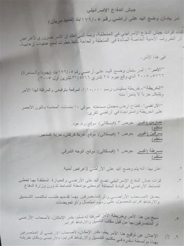
Israeli occupation forces issued an eviction order of agricultural lands in the village of Al Jaba’ west of Bethlehem City. The eviction order was issued on February 8, 2012, by the so-called Israeli “Civil Administration”.
 

Pic.1: The eviction order
 
The owner of the targeted lands, Mr. Khaled Naji Masha’aleh, indicated for the Land Research Center (LRC)’s field researcher that he found the Order in his land located north of the village. The Order was accompanied with an aerial photo of the targeted lands with an area of 20 dunums.
 
The Order indicated that the land is considered “State Lands” which means that it is a property of the State of Israel. It also gave the owners a mere 45 days from the date of the issuing of the Order to get the land to its “previous status”. In the case he doesn’t, the Order stipulated that the Israeli occupation forces would carry out the eviction and make the land owner pay for the expenses. The land is planted with around 200 olive trees.


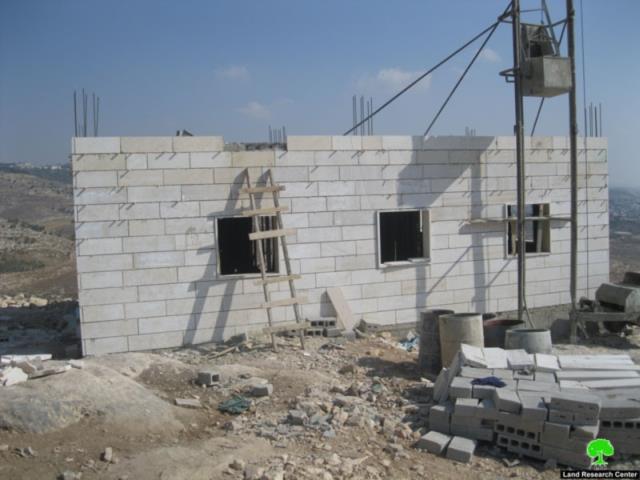
Pic.2-5: A general view of targeted lands.
 
Mr. Masha’aleh complained of the large number of eviction and stop work orders issued by the occupation forces targeting his lands. He, also, indicated that these forces have always caused damages (in the form of tree cutting and uprooting) for his land; in the year 2005 Israeli occupation forces uprooted 800 olive trees made available to Mr. Masha’aleh from the Ministry of Agriculture.
 
 
Pic.6: A previous Order delivered to Mr. Masha’aleh

Pic.7: A document proving the ownership of Mr. Masha’aleh to his land
 
He also indicated that the lands of his relatives are also targeted; in the year 2005 Israeli occupation forces uprooted an additional 200 olive trees from the lands of Mr. Ahmad Mohammad Hussein Masha’aleh as well as Mr. Mohammad Deib Masha’aleh and his brothers. Moreover, the occupation forces demolished a 70-cubic meter cistern that was used to irrigate the uprooted trees. Mr. Masha’aleh added that the occupation forces cut down trees in 20 dunums owned by the Hamdan clan which are located close to the lands of Al Masha’aleh. The number of cut down olive trees reached 300.  
 
Mr. Masha’aleh expressed his belief that such actions point to a dedicated policy aimed at vacating the Palestinian lands as a pre-step of confiscating the lands to be used later for further colonial expansion especially for the nearby huge colony of Beitar Illit which overlooks the Jaba’ lands from the eastern and northern directions.
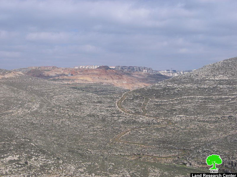
Pic.8: The colony of Beitar Illit overlooking Al Masha’aleh lands. lands.
Prepared by
The Land Research Center
LRC

Recommended For You

مناطق نفوذ المستوطنات ودورها في إعادة تشكيل الجغرافيا الفلسطينية

by arij
April 23, 2026
0
مناطق نفوذ المستوطنات ودورها في إعادة تشكيل الجغرافيا الفلسطينية

أصدرت سلطات الاحتلال الإسرائيلي في العاشر من شهر نيسان 2026 الكراسة رقم (273)، وهي وثيقة تضم مجموعة من المناشير والأوامر والتعيينات الإسرائيلية المتعلقة بالجوانب الأمنية والعسكرية والإدارية، إضافة...

Read moreDetails

INFOGRAPHIC: Mapping Control – Israeli Militray Orders across the occupied West Bank – 2025

by arij
April 16, 2026
0

    Prepared by:   The Applied Research Institute – Jerusalem

Read moreDetails

سلطات الاحتلال الإسرائيلي تستهدف قرية الجيب بأمر عسكري جديد

by arij
March 17, 2026
0
سلطات الاحتلال الإسرائيلي تستهدف قرية الجيب بأمر عسكري جديد

نشر المسؤول عن الأملاك الحكومية وأملاك الغائبين في الإدارة المدنية الإسرائيلية في الحادي عشر من شهر اذار من العام 2026 اعلاننا مفاده نية ما يسمى " المسؤول عن...

Read moreDetails

سلطات الاحتلال الإسرائيلي تستخدم الأوامر العسكرية لتعمق المشروع الاستيطاني في الضفة الغربية المحتلة

by arij
February 26, 2026
0
سلطات الاحتلال الإسرائيلي تستخدم الأوامر العسكرية لتعمق المشروع الاستيطاني في الضفة الغربية المحتلة

تقديم منذ احتلال الضفة الغربية عام 1967، اعتمدت سلطات الاحتلال الإسرائيلي منهجية واسعة عبر استخدام الأوامر العسكرية كأداة "قانونية" لفرض الوقائع الجغرافية والديموغرافية على الأرض الفلسطينية. وأصبحت هذه...

Read moreDetails

بين مطرقة الأوامر العسكرية وسندان التقييد الجغرافي, أوامر عسكرية إسرائيلية جديدة تطال أكثر من 1000 دونم في طوباس

by arij
November 26, 2025
0
بين مطرقة الأوامر العسكرية وسندان التقييد الجغرافي, أوامر عسكرية إسرائيلية جديدة تطال أكثر من 1000 دونم في طوباس

في الحادي والعشرين من شهر تشرين الأول لعام 2025، تسلّم أهالي محافظة طوباس سلسلة من الأوامر العسكرية الإسرائيلية التي استهدفت مساحات واسعة من الأراضي الفلسطينية في المحافظة. وقد...

Read moreDetails
Next Post
Extension of Take Over lands in Bruqin, Sarta, and Haris villages

Extension of Take Over lands in Bruqin, Sarta, and Haris villages

LATEST NEWS

بين قصرة وترمسعيا: العنف الاستيطاني الاسرائيلي يضرب المجتمع الفلسطيني

by arij
May 6, 2026
0

........................................................

مناطق نفوذ المستوطنات ودورها في إعادة تشكيل الجغرافيا الفلسطينية

مناطق نفوذ المستوطنات ودورها في إعادة تشكيل الجغرافيا الفلسطينية

by arij
April 23, 2026
0

........................................................

التمدد الاستيطاني الإسرائيلي في الضفة الغربية المحتلة وأثره في تقويض مقومات الدولة الفلسطينية

التمدد الاستيطاني الإسرائيلي في الضفة الغربية المحتلة وأثره في تقويض مقومات الدولة الفلسطينية

by arij
April 16, 2026
0

........................................................

INFOGRAPHIC: ISRAELI SETTLER VIOLENCE IN 2025

by arij
April 16, 2026
0

........................................................

flag_yellow_lowEU-PfP-Logo

This website and its content were initiated in 1993 by the Applied Research Institute – Jerusalem (ARIJ) and the Land Research Center (LRC) with the support from the European Union up until 2023. Since then, the Applied Research Institute – Jerusalem (ARIJ) has taken over the continued development and maintenance of the website. The views expressed remain solely those of ARIJ) and do not necessarily reflect those of the European Union.

© 2026 Copyright | ARIJ | All Rights reserved.

No Result
View All Result
  • Home
  • Settlements
    • New Israeli Settlements
    • Settlement Expansion
  • Israeli Violations
    • Agriculture
    • Confiscation
    • Demolition
    • Environment
    • Eviction of Palestinians
    • Settlers Attacks
  • Bypass Roads
  • Israeli Plans
  • Segregation
    • Checkpoints
    • Closure
    • Separation Plans
  • Military Orders
  • Reports
    • Daily Report
    • Monthly Report
    • Quarterly Report

© 2026 Copyright | ARIJ | All Rights reserved.