• About The Project
  • Palestine in Century
  • Selected Maps
  • Glossary
  • About ARIJ
  • About LRC
  • By Year
    • Case Studies By Year
    • Daily Report By Year
Saturday, May 23, 2026
POICA
No Result
View All Result
  • Home
  • Settlements
    • New Israeli Settlements
    • Settlement Expansion
  • Israeli Violations
    • Agriculture
    • Confiscation
    • Demolition
    • Environment
    • Eviction of Palestinians
    • Settlers Attacks
  • Bypass Roads
  • Israeli Plans
  • Segregation
    • Checkpoints
    • Closure
    • Separation Plans
  • Military Orders
  • Reports
    • Daily Report
    • Monthly Report
    • Quarterly Report
No Result
View All Result
POICA
No Result
View All Result

The Israeli Occupation Issues Stop-Work Orders in Al ‘Aqaba village

April 2, 2011
in Military Orders
The Israeli Occupation Issues Stop-Work Orders in Al ‘Aqaba village
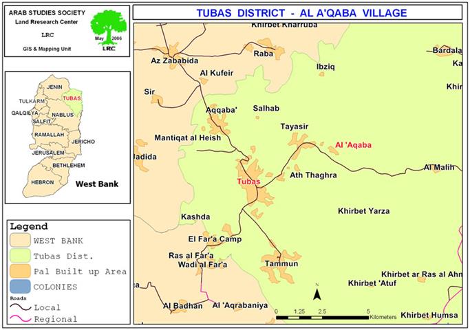
Violation: the Israeli Occupation issues seven stop-work orders in Al ‘Aqaba.
Perpetrators: the Israeli Occupation Construction and Inspection sub-committee.
Victims: a number of Al ‘Aqaba villagers.
Date: March 30, 2011.
 

Details:
Concurrently with the Palestinian “Land Day”, a day were Palestinians commemorate and renew their commitment to their lands and their struggle despite all the Israeli oppressions and aggressions, the Israelis issued the stop-work orders under the lame pretext of “no building permits”. It must be noted that the Israeli Occupation does not recognize Al ‘Aqaba village and threatens all the structures there with demolition or eviction.
 
  
Picture : 1-3
 
Table 1: information on the notified structures:
No.
Victim
Family members
Children
Structure type
Area (m2)
1
Abdul Nassir Sbeih
9 5
Shack
12
2
Abdul Nassir Sbeih
— —
Residence
100
3
Khalid Sbeih
6 4
Residence
100
4
Khalid Sbeih
— —
Shack
16
5
Bassim Sbeih
4 2
Shack
14
6
Road – village entrance
   
Eastern side
950 m, built over two years ago
7
Road – village entrance
   
 
400 m, built less than a year ago
Total
19 11


The total number of orders issued against structures in Al ‘Aqaba has reached 55 orders since 2005. It must be noted that Al ‘Aqaba, just like any other Palestinian community in the Jordan Valley region lack an Organizational structures because the Israeli Occupation does not recognize these communities which lie in area classified ‘C’ according to Oslo Agreement. He village Council tried to appeal to the Israeli Supreme Court but their efforts were in vain.
 
Al ‘Aqaba is located 7 km to the east of Tubas City; its residents have been depending on herding and agriculture in their living for tens of years. Al ‘Aqaba total area is 5500 dunums, 3500, are rigestered under the Jordanian laws and 2000 dunums are property of Christian churches.Al ‘Aqaba total area is 5500 dunums, 3500, are rigestered under the Jordanian laws and 2000 dunums are property of Christian churches.
Prepared by
The Land Research Center
LRC


Recommended For You

سلطات الاحتلال الإسرائيلي بصدد الاستيلاء على موقع قبر النبي صموئيل شمال غرب مدينة القدس

by arij
May 23, 2026
0
سلطات الاحتلال الإسرائيلي بصدد الاستيلاء على موقع قبر النبي صموئيل شمال غرب مدينة القدس

 نشرت سلطات الاحتلال الإسرائيلي في الثامن عشر من شهر أيار من العام 2026 اعلانا مفاده الاستيلاء على الأراضي الفلسطينية في قرية النبي صموئيل شمال غرب القدس المحتلة. وجاء...

Read moreDetails

إقامة منطقة عسكرية عسكرية داخل أراضي (أ) في جنين

by arij
May 19, 2026
0
إقامة منطقة عسكرية عسكرية داخل أراضي (أ) في جنين

   في السابع من شهر أيار من العام 2026، وزعت سلطات الاحتلال الإسرائيلي أمرا عسكريا جديدة على أهالي مدينة جنين يقضي بمصادرة 7.2 دونما من الأراضي الفلسطينية في...

Read moreDetails

“بمساحة اجمالية 177 دونما من أرضي البيرة وبيتين”, طريق استيطاني لخدمة البؤر الاستيطانية في محافظة رام الله

by arij
May 18, 2026
0
“بمساحة اجمالية 177 دونما من أرضي البيرة وبيتين”, طريق استيطاني لخدمة البؤر الاستيطانية في محافظة رام الله

في الحادي عشر من شهر أيار من العام 2026, نشرت دائرة أراضي إسرائيل اعلانا جديدا يقضي بمصادرة المزيد من الأراضي الفلسطينية في محافظة رام الله لأغراض استيطانية في...

Read moreDetails

“في خدمة مستوطنة ناحال حيلتس”, طريق استيطاني إسرائيلي جديد على أراضي بتير وبيت جالا في محافظة بيت لحم

by arij
May 18, 2026
0
“في خدمة مستوطنة ناحال حيلتس”, طريق استيطاني إسرائيلي جديد على أراضي بتير وبيت جالا في محافظة بيت لحم

تواصل سلطات الاحتلال الإسرائيلي إحكام سيطرتها على المزيد من الأراضي الفلسطينية في الضفة الغربية المحتلة، وهذه المرة من خلال استهداف أراضي محافظة بيت لحم. ففي السادس والعشرين من...

Read moreDetails

مناطق نفوذ المستوطنات ودورها في إعادة تشكيل الجغرافيا الفلسطينية

by arij
April 23, 2026
0
مناطق نفوذ المستوطنات ودورها في إعادة تشكيل الجغرافيا الفلسطينية

أصدرت سلطات الاحتلال الإسرائيلي في العاشر من شهر نيسان 2026 الكراسة رقم (273)، وهي وثيقة تضم مجموعة من المناشير والأوامر والتعيينات الإسرائيلية المتعلقة بالجوانب الأمنية والعسكرية والإدارية، إضافة...

Read moreDetails
Next Post
Intensive Israeli Colonial Attacks against the Palestinian People and Their Properties in the Occupied Territory

Intensive Israeli Colonial Attacks against the Palestinian People and Their Properties in the Occupied Territory

LATEST NEWS

سلطات الاحتلال الإسرائيلي بصدد الاستيلاء على موقع قبر النبي صموئيل شمال غرب مدينة القدس

سلطات الاحتلال الإسرائيلي بصدد الاستيلاء على موقع قبر النبي صموئيل شمال غرب مدينة القدس

by arij
May 23, 2026
0

........................................................

إقامة منطقة عسكرية عسكرية داخل أراضي (أ) في جنين

إقامة منطقة عسكرية عسكرية داخل أراضي (أ) في جنين

by arij
May 19, 2026
0

........................................................

الآثار كأداة للضم الزاحف: مشروع القانون الإسرائيلي لإعادة هندسة الجغرافيا والهوية في الضفة الغربية

الآثار كأداة للضم الزاحف: مشروع القانون الإسرائيلي لإعادة هندسة الجغرافيا والهوية في الضفة الغربية

by arij
May 23, 2026
0

........................................................

النكبة الفلسطينية في ذكراها الثامنة والسبعين: من التطهير العرقي إلى الإبادة وإعادة هندسة الجغرافيا الفلسطينية 

النكبة الفلسطينية في ذكراها الثامنة والسبعين: من التطهير العرقي إلى الإبادة وإعادة هندسة الجغرافيا الفلسطينية 

by arij
May 18, 2026
0

........................................................

flag_yellow_lowEU-PfP-Logo

This website and its content were initiated in 1993 by the Applied Research Institute – Jerusalem (ARIJ) and the Land Research Center (LRC) with the support from the European Union up until 2023. Since then, the Applied Research Institute – Jerusalem (ARIJ) has taken over the continued development and maintenance of the website. The views expressed remain solely those of ARIJ) and do not necessarily reflect those of the European Union.

© 2026 Copyright | ARIJ | All Rights reserved.

No Result
View All Result
  • Home
  • Settlements
    • New Israeli Settlements
    • Settlement Expansion
  • Israeli Violations
    • Agriculture
    • Confiscation
    • Demolition
    • Environment
    • Eviction of Palestinians
    • Settlers Attacks
  • Bypass Roads
  • Israeli Plans
  • Segregation
    • Checkpoints
    • Closure
    • Separation Plans
  • Military Orders
  • Reports
    • Daily Report
    • Monthly Report
    • Quarterly Report

© 2026 Copyright | ARIJ | All Rights reserved.