• About The Project
  • Palestine in Century
  • Selected Maps
  • Glossary
  • About ARIJ
  • About LRC
  • By Year
    • Case Studies By Year
    • Daily Report By Year
Wednesday, June 3, 2026
POICA
No Result
View All Result
  • Home
  • Settlements
    • New Israeli Settlements
    • Settlement Expansion
  • Israeli Violations
    • Agriculture
    • Confiscation
    • Demolition
    • Environment
    • Eviction of Palestinians
    • Settlers Attacks
  • Bypass Roads
  • Israeli Plans
  • Segregation
    • Checkpoints
    • Closure
    • Separation Plans
  • Military Orders
  • Reports
    • Daily Report
    • Monthly Report
    • Quarterly Report
No Result
View All Result
POICA
No Result
View All Result

Demolition notifications against a number of houses and installations

February 25, 2011
in Military Orders
Demolition  notifications against a number of houses and installations
Violation: threatening four houses and a number of installations with demolition
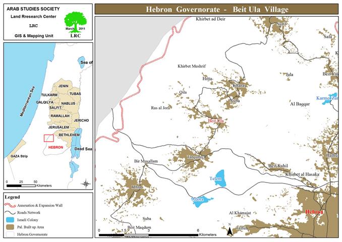
Location: Attus, Bit Ula
Date: 21/2/2011
Perpetrator: The Israeli occupation army
Affected party:  l Amlah extended family.


Introduction:
Beit Ula, located about 14 km north of Hebron city, a town as old as history, took its name from the Aramaic language meaning the noble house. First inhabited by Arab Canaanites, and ever since the character of the town has been an Arab, despite the circulation of some cultures and occupations through its long history, such as Jews, Greeks, Romans and Byzantines. On the land of the town reside  a number of shrines and Maqams belonging to some of Muslim saints and righteous people. There is, also, a mosque  under the name of the second Muslim Khalif, Omer Bin Al Khattab, commemorating his passage through the village on the way to conquest the city of Jerusalem from the Byzantine on 638 AD.
 
 Area and Population:
 The total area of ​​the town is 22,202 dunum ( 1 dunum =1000 M2)  including 1455 dunum as built up area. Apart from this area a total of  9000 dunum were lost to Israel as a result of 1948 war.  An additional ​​2000 dunums were, also, lost after the war of 1067 for building Israeli colonies and most recently for the construction of the Segregation Wall.
 
According to the figures of the Palestinian Central Bureau of Statistics (PCBS) published in 2009, the total citizens of the town were 11000. The town is bordered form north by Nuba, from south by Tarqumya, from east by Halhul and Beit Kahil and from west by the green line. The town has gone under a series of fierce attacks by the occupation authorities since the military occupation of 1967, the latest of which is the issuance of notifications  of demolition against a number of housing facilities and installations under the pretext of un-licensing.
 
Details of the violation:
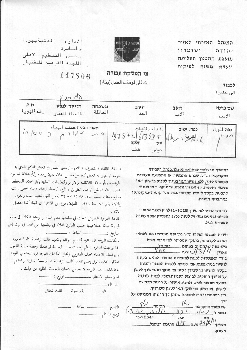
On February 21, 2011 the Israeli occupation authorities handed over four owners notices to stop work and construction of 3 houses, 3 water wells, and two stores and a bathroom, under the pretext of building without permits on the territory of zone C classified by Oslo Agreement. According to the distributed notifications, the so-called Israeli Sub-Commission for inspection will hold a hearing on 03/03/2011 at 9:00 to decide about the cases and return the location to the previous state according to their validity by the law of the organization of cities, villages and buildings, Article 38, No. 79 of 1966. The notifications, also, requested an immediate stop of all construction activities.
 
Attos- Beit Ula:  An aerial view shows the geographical location of homes threatened with demolition
 
Table 1
The following table shows the names of citizens whose homes and installations have been threatened with demolition:
 
No
Name of affected person
No. of installati-ons
Area
M2
No. of family members
Children under  18
Year of construction
Type
No. of notification
1
Samir Ahmad Amro Al Amlah
3
70
6
2
2009
A house built of bricks and asbestos+store+cistern
147805
2
Nimer Abdul Rahman  Al Amlah
3
50
4
2
2010
A house built of bricks and tin+toilet+cistern
147807
3
Mohammed Abdul Rahim Al Amlah
1
100
9
4
2009
A house built of bricks and tin
147806
4
Ibrahim Yusif  Al Amlah
2
40
6
4
2010
A house built of mud+cistern
147804
Total
9
260
25
12


Source: field -work by LRC
Photo 1: Attos – Beit Ula: Housing and Establishments Threatened


Photo 2: Attos – Beit Ula: Ibrahim Nimr’s facility threatened with demolition 

Prepared by
The Land Research Center
LRC


Recommended For You

سلطات الاحتلال الإسرائيلي بصدد الاستيلاء على موقع قبر النبي صموئيل شمال غرب مدينة القدس

by arij
May 23, 2026
0
سلطات الاحتلال الإسرائيلي بصدد الاستيلاء على موقع قبر النبي صموئيل شمال غرب مدينة القدس

 نشرت سلطات الاحتلال الإسرائيلي في الثامن عشر من شهر أيار من العام 2026 اعلانا مفاده الاستيلاء على الأراضي الفلسطينية في قرية النبي صموئيل شمال غرب القدس المحتلة. وجاء...

Read moreDetails

إقامة منطقة عسكرية عسكرية داخل أراضي (أ) في جنين

by arij
May 19, 2026
0
إقامة منطقة عسكرية عسكرية داخل أراضي (أ) في جنين

   في السابع من شهر أيار من العام 2026، وزعت سلطات الاحتلال الإسرائيلي أمرا عسكريا جديدة على أهالي مدينة جنين يقضي بمصادرة 7.2 دونما من الأراضي الفلسطينية في...

Read moreDetails

“بمساحة اجمالية 177 دونما من أرضي البيرة وبيتين”, طريق استيطاني لخدمة البؤر الاستيطانية في محافظة رام الله

by arij
May 18, 2026
0
“بمساحة اجمالية 177 دونما من أرضي البيرة وبيتين”, طريق استيطاني لخدمة البؤر الاستيطانية في محافظة رام الله

في الحادي عشر من شهر أيار من العام 2026, نشرت دائرة أراضي إسرائيل اعلانا جديدا يقضي بمصادرة المزيد من الأراضي الفلسطينية في محافظة رام الله لأغراض استيطانية في...

Read moreDetails

“في خدمة مستوطنة ناحال حيلتس”, طريق استيطاني إسرائيلي جديد على أراضي بتير وبيت جالا في محافظة بيت لحم

by arij
May 18, 2026
0
“في خدمة مستوطنة ناحال حيلتس”, طريق استيطاني إسرائيلي جديد على أراضي بتير وبيت جالا في محافظة بيت لحم

تواصل سلطات الاحتلال الإسرائيلي إحكام سيطرتها على المزيد من الأراضي الفلسطينية في الضفة الغربية المحتلة، وهذه المرة من خلال استهداف أراضي محافظة بيت لحم. ففي السادس والعشرين من...

Read moreDetails

مناطق نفوذ المستوطنات ودورها في إعادة تشكيل الجغرافيا الفلسطينية

by arij
April 23, 2026
0
مناطق نفوذ المستوطنات ودورها في إعادة تشكيل الجغرافيا الفلسطينية

أصدرت سلطات الاحتلال الإسرائيلي في العاشر من شهر نيسان 2026 الكراسة رقم (273)، وهي وثيقة تضم مجموعة من المناشير والأوامر والتعيينات الإسرائيلية المتعلقة بالجوانب الأمنية والعسكرية والإدارية، إضافة...

Read moreDetails
Next Post
تهديد عدداً من المساكن والمنشآت بالهدم

تهديد عدداً من المساكن والمنشآت بالهدم

LATEST NEWS

سلطات الاحتلال الإسرائيلي بصدد الاستيلاء على موقع قبر النبي صموئيل شمال غرب مدينة القدس

سلطات الاحتلال الإسرائيلي بصدد الاستيلاء على موقع قبر النبي صموئيل شمال غرب مدينة القدس

by arij
May 23, 2026
0

........................................................

إقامة منطقة عسكرية عسكرية داخل أراضي (أ) في جنين

إقامة منطقة عسكرية عسكرية داخل أراضي (أ) في جنين

by arij
May 19, 2026
0

........................................................

الآثار كأداة للضم الزاحف: مشروع القانون الإسرائيلي لإعادة هندسة الجغرافيا والهوية في الضفة الغربية

الآثار كأداة للضم الزاحف: مشروع القانون الإسرائيلي لإعادة هندسة الجغرافيا والهوية في الضفة الغربية

by arij
May 23, 2026
0

........................................................

النكبة الفلسطينية في ذكراها الثامنة والسبعين: من التطهير العرقي إلى الإبادة وإعادة هندسة الجغرافيا الفلسطينية 

النكبة الفلسطينية في ذكراها الثامنة والسبعين: من التطهير العرقي إلى الإبادة وإعادة هندسة الجغرافيا الفلسطينية 

by arij
May 18, 2026
0

........................................................

flag_yellow_lowEU-PfP-Logo

This website and its content were initiated in 1993 by the Applied Research Institute – Jerusalem (ARIJ) and the Land Research Center (LRC) with the support from the European Union up until 2023. Since then, the Applied Research Institute – Jerusalem (ARIJ) has taken over the continued development and maintenance of the website. The views expressed remain solely those of ARIJ) and do not necessarily reflect those of the European Union.

© 2026 Copyright | ARIJ | All Rights reserved.

No Result
View All Result
  • Home
  • Settlements
    • New Israeli Settlements
    • Settlement Expansion
  • Israeli Violations
    • Agriculture
    • Confiscation
    • Demolition
    • Environment
    • Eviction of Palestinians
    • Settlers Attacks
  • Bypass Roads
  • Israeli Plans
  • Segregation
    • Checkpoints
    • Closure
    • Separation Plans
  • Military Orders
  • Reports
    • Daily Report
    • Monthly Report
    • Quarterly Report

© 2026 Copyright | ARIJ | All Rights reserved.