
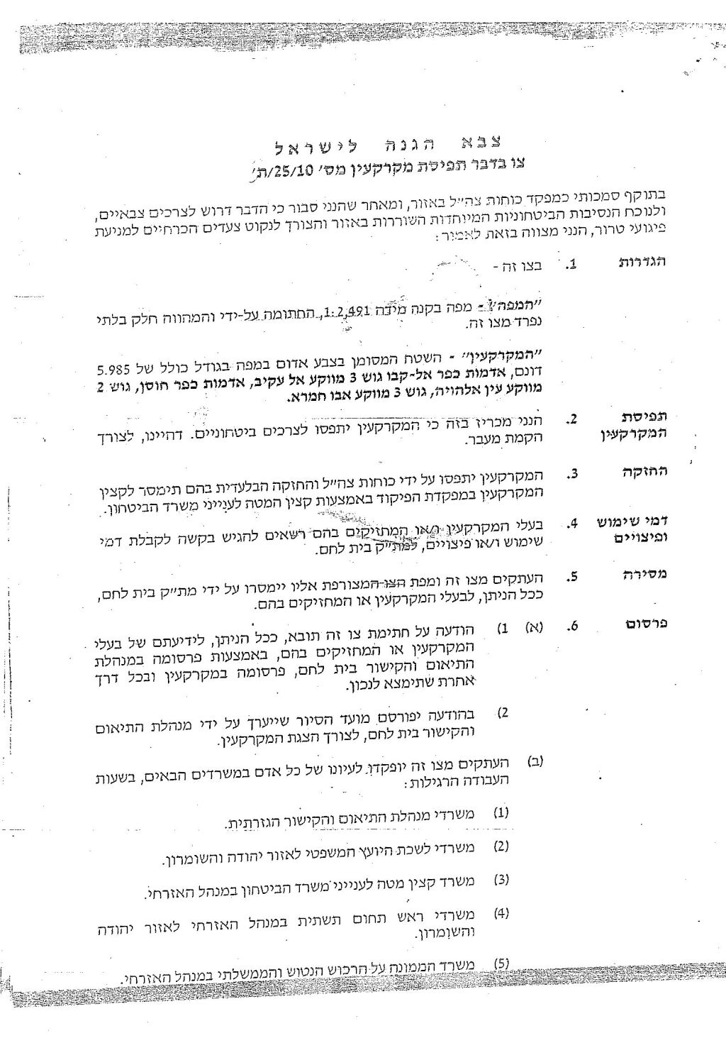
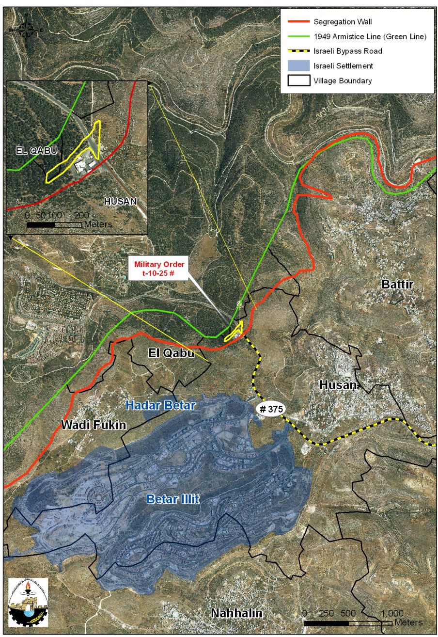
On October 6, 2010, the Israeli Occupation Authorities served citizens of Husan and Al Qabu villages west of Bethlehem city a new military order numbered 25/10/T which states the confiscation of 5.985 dunums of lands of the two villages for military purposes, to construct a crossing passage. The location where the new crossing passage will be constructed is within the area slated for isolation from the two villages upon wall completion.See Copy of the military order and maps

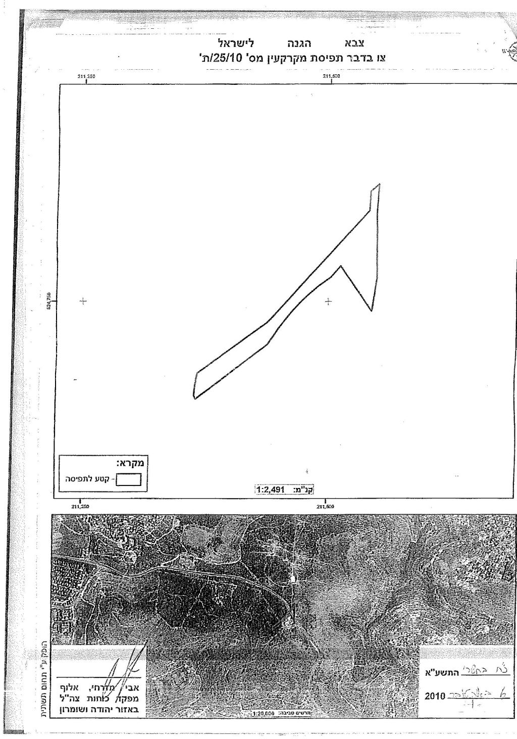
An analysis conducted by the Applied Research Institute – Jerusalem (ARIJ) team showed that the area that the military order will confiscate is about ten dunums, five dunums more than stipulated in the military order itself, of which, 1.8 dunums are to be confiscated from Al Qabu village, while the remaining area is to be confiscated from Husan village. Table 1 gives details of the confiscated lands in both villages.
|
Table 1: Confiscated Palestinian lands according to military order number 25/10/T
|
||||
|
No.
|
Village Name
|
Area confiscated
|
Parcel Number
|
Location Name
|
|
1
|
Husan
|
8
|
2
|
‘Ein Al Hawiya
|
|
3
|
Abu Hamra
|
|||
|
2
|
Al Qabu
|
1.8
|
3
|
Al ‘Aqeib
|
|
Total Confiscated Area
|
9.8
|
|
|
|
Source: Geographical Information system Unit – ARIJ, 2010
Map 1: The Israeli Military Order number 25/10/T
The Israeli military order also gave citizens of Husan and Al Qabu Villages a period of 7 days to file objections to the Israeli Laison Office in Bethlehem Governorate and to get more information about their right of land use expenses and compensation. The Validity of this order starts at the date signed till December 31, 2012. The threatened site lies next to an Israeli Gas Station which was illegally established on lands of Husan village in 1992 on a 9 dunums land area at the hands of an Israeli settler living in the nearby Israeli settlement of Betar Illit. See Map 2
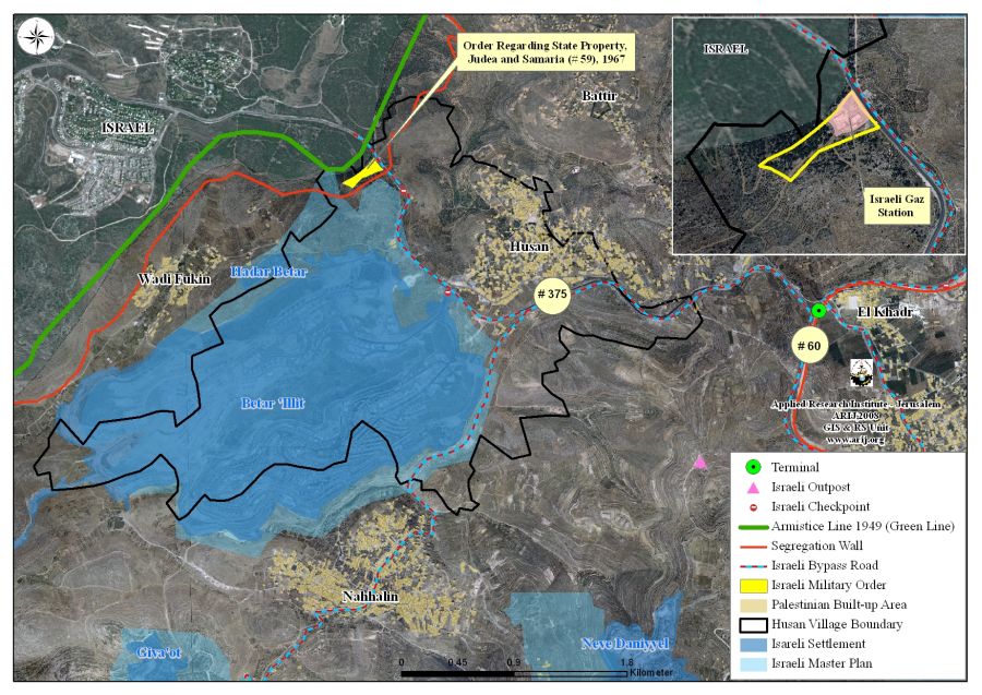
It is worth pointing out that the same area was targeted in November 2008 by a military order issued by the Israeli Custodian of Absentee Land Property of Judea and Samaria in the Israeli Army (Yosi Sigal) which stated the confiscation of lands conducted under the pretext of ‘State Property’. The order, given the name ‘Order Regarding state property, Judea and Samaria (59), 1967’, stipulated the confiscation of 23.351 dunums of Husan village lands, block number 3, in Abu Hamra valley area located alongside the Israeli bypass Road # 375.
The new crossing passage which Israel intends to construct on lands of Husan and Al Qabu villages (as stipulated in the military order) will replace an Israeli military checkpoint located south of the gas station. In addition, it is the seventh crossing border to be built or has already been built on lands of Bethlehem Governorate in order to control the movement of Palestinian citizens and goods in the Bethlehem governorate once they’re fully constructed. Below is a detailed description of each of the crossing borders to be constructed in Bethlehem Governorate:-
1. Gilo 300 Border Crossing at Bethlehem Northern Entrance – Status: Operational: It was inaugurated on November 15, 2005. This border crossing allows the movement to Palestinian passengers holding special permits issued by the Israeli civil administration which allows them to enter Jerusalem; tourists; and diplomatic and religious missions.
2. Mazmuria Trade terminal at Bethlehem eastern entrance – Status: Operational: Palestinians are not allowed through the terminal and the terminal is designated only for Jews.
3. Al Jab’a Trade passage – Status: in Planning phase: it will replace the existing Al Jab’a checkpoint located west of the village and close to the 1949 Armistice Line (Green Line).
4. Al Khader Crossing Passage – Status: under construction: it will link Bethlehem western rural villages (Battir, Husan, Nahalin, Wadi Fukin and Al Walajeh) that will be segregated west of the Wall (once completed) with Al Khader village and the rest of Bethlehem Governorate located east of the Segregation Wall.
5. Al Walajeh Terminal – Status: in planning phase: it will control the access of Al Walajeh residents into and out of the village. The terminal is complementary to the Israeli Segregation Plan in Al Walajeh village as the Wall is intended to encircle the village from its northern, eastern and western sides while the southern part will be bounded by Israeli bypass road number 436 which connects Har Gilo settlement with west Jerusalem.
6. Umm Salamuna Terminal- Status: in planning phase: The plan for Um Salamuna terminal comes to serve Israeli policy to tighten Palestinian movement and access to their agricultural lands, but more than that, it will serve as a commercial terminal leading to alternative route for trucks to use in order to avoid using the settlers bypass road 60.
To conclude:-
The Israeli built or under construction terminals and passages along the route of the Segregation Wall in the West Bank is indisputable form of ‘collective punishment’ practiced by Israel against the Palestinians and intended to tighten and confine the areas where Palestinian move from one place to another. It also reflects Israel’s objective to unilaterally reshape the geographical and political map of the Occupied Territory by imposing facts on the ground according to the Israeli colonial interests. Article 2 in the Universal Declaration of Human Rights states that: ‘Everyone is entitled to all the rights and freedoms set forth in this Declaration, without distinction of any kind, such as race, color, sex, language, religion, political or other opinion, national or social origin, property, birth or other status. Furthermore, no distinction shall be made on the basis of the political, jurisdictional or international status of the country or territory to which a person belongs, whether it be independent, trust, non-self-governing or under any other limitation of sovereignty.’ Also Article 13 states also that: Everyone has the right to freedom of movement and residence within the borders of each state.’
Prepared by


