• About The Project
  • Palestine in Century
  • Selected Maps
  • Glossary
  • About ARIJ
  • About LRC
  • By Year
    • Case Studies By Year
    • Daily Report By Year
Sunday, May 31, 2026
POICA
No Result
View All Result
  • Home
  • Settlements
    • New Israeli Settlements
    • Settlement Expansion
  • Israeli Violations
    • Agriculture
    • Confiscation
    • Demolition
    • Environment
    • Eviction of Palestinians
    • Settlers Attacks
  • Bypass Roads
  • Israeli Plans
  • Segregation
    • Checkpoints
    • Closure
    • Separation Plans
  • Military Orders
  • Reports
    • Daily Report
    • Monthly Report
    • Quarterly Report
  • Home
  • Settlements
    • New Israeli Settlements
    • Settlement Expansion
  • Israeli Violations
    • Agriculture
    • Confiscation
    • Demolition
    • Environment
    • Eviction of Palestinians
    • Settlers Attacks
  • Bypass Roads
  • Israeli Plans
  • Segregation
    • Checkpoints
    • Closure
    • Separation Plans
  • Military Orders
  • Reports
    • Daily Report
    • Monthly Report
    • Quarterly Report
No Result
View All Result
POICA
No Result
View All Result

Israeli Occupation Forces Issue 10 Stop Work Orders against Structures in the Village of Bardala

August 23, 2010
in Military Orders
Violation:
Date: The 18th of July, 2010
 
Details:
The so-called Building and Organization Committee of the Israeli occupation’s “Civil Administration” raided the village of Bardala on the said date accompanied by a large number of Israeli occupation forces. An officer in the “Civil Administration” notified 9 Palestinians that there are written Stop Works orders issued against their agricultural and residential structures in the village. The orders were issued under the pretext of building in an area classified as Area C without a permit from the Israeli authorities.
 
 
Pic.1: Some of the threatened structures – Bardala
 
The orders provided a time period until the 19th of August, 2010, for the structures owners to come to court the court in Bet El for the purpose of “starting the needed procedures to be issued the needed permits” from the Israeli occupation authority.
 
At the same time that the Stop Work orders were delivered, another eviction order was submitted to Mr. Khaled Rushdi Sawafta instructing him to vacate his residency place as it is located in “a Closed Military Zone,” according to the order. It should be pointed out that the indicated area is located not more than 40 meters away from the houses in the eastern side of the village. Mr. Sawafta owns a shelter made out of zinc in addition to 5 agricultural bruxes and a warehouse used to store fodder for his animals. Occupation forces gave him only 24 hours to remove the structures on his own. Otherwise, he was threatened to face similar fate like the structures in Al Farisiyya.   
 
The following table provides general information regarding the newly-delivered 10 orders:
 
No.
Name
Area
No. of Structures
Family Members
Children
Type of Structures
Order Type
Order No.
1
Mohammad Tahseen Hasan
120
1
1
–
1-story houses ready to be inhabited
Stop Work
2
Mahmoud Tahseen Hasan
100
1
2
–
Under-construction basement
Stop Work
3
Mohammad Awwad Rashayda
140
1
9
7
Under-construction house
Stop Work
4
Ahmad Khneifis Rashayda
280
2
9
2
2-story house under construction
Stop Work
5
Khaled Rushdi Sawafta
0
7
7
2
Zinc shelter, 5 agricultural bruxes and a fodder storage.
Evacuation from a Closed Military Area
6
Mahmoud Faleh Rabaya’a
80
1
6
2
Sheep brux
Stop Work
7
Ra’afat Faleh Rabaya’a
90
1
2
 
Sheep brux
Stop Work
8
Hussein Faleh Rabaya’a
45
1
5
2
Sheep brux
Stop Work
9
Hazza’a Faleh Rabaya’a
80
1
7
2
Sheep brux
Stop Work
 
10
Faleh Mahmoud Rabaya’a
70
1
4
2
Sheep brux
Stop Work
TOTAL
1005
14
52
19


The Village of Bardala:
The village is located north east of the Jordan Valley at a distance of 24 kilometers east of the city of Tubas in Tubas Governorate. It is bounded by the village of Tayaseer in the west, Ein Al Beida in the north, the Jordan River in the east and Ein Al Maleh in the south.
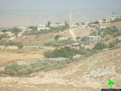
 
   
Pic.2+3: A general view of the village of Bardala
 
 
The overall area of the village is about 31,000 dunums distributed as follows; 7,000 dunums are currently located behind and beneath the Racist Israeli Segregation Wall. The surface area of the village itself is only 350 dunums, 250 dunums covered with Green Houses, 100 dunums of irrigated trees while an additional 54 dunums were confiscated by the Israeli occupation authorities for the benefit of By-Pass Road 90. An additional 12,000 dunums are used for non-irrigated plants while an additional 10,000 dunums are planted with irrigated vegetables. The remaining lands are used for grazing purposes.
 
The population of the village, according to the figures of PCBS for the year 2009, stands at 2,154. About 99% of the population depends on agriculture and raising livestock as the two main sources of income. There are about 5,000 sheep in the village.
 
It is worth mentioning that the population of Bardala has its roots from the city of Tubas. A large number of the city folks moved to Bardala due to the presence of grazing areas and spring water. The main clan in the village is the clan of Sawafta while 10% of the population is wandering Bedouin families.


Prepared by
The Land Research Center
LRC

 

Recommended For You

سلطات الاحتلال الإسرائيلي بصدد الاستيلاء على موقع قبر النبي صموئيل شمال غرب مدينة القدس

by arij
May 23, 2026
0
سلطات الاحتلال الإسرائيلي بصدد الاستيلاء على موقع قبر النبي صموئيل شمال غرب مدينة القدس

 نشرت سلطات الاحتلال الإسرائيلي في الثامن عشر من شهر أيار من العام 2026 اعلانا مفاده الاستيلاء على الأراضي الفلسطينية في قرية النبي صموئيل شمال غرب القدس المحتلة. وجاء...

Read moreDetails

إقامة منطقة عسكرية عسكرية داخل أراضي (أ) في جنين

by arij
May 19, 2026
0
إقامة منطقة عسكرية عسكرية داخل أراضي (أ) في جنين

   في السابع من شهر أيار من العام 2026، وزعت سلطات الاحتلال الإسرائيلي أمرا عسكريا جديدة على أهالي مدينة جنين يقضي بمصادرة 7.2 دونما من الأراضي الفلسطينية في...

Read moreDetails

“بمساحة اجمالية 177 دونما من أرضي البيرة وبيتين”, طريق استيطاني لخدمة البؤر الاستيطانية في محافظة رام الله

by arij
May 18, 2026
0
“بمساحة اجمالية 177 دونما من أرضي البيرة وبيتين”, طريق استيطاني لخدمة البؤر الاستيطانية في محافظة رام الله

في الحادي عشر من شهر أيار من العام 2026, نشرت دائرة أراضي إسرائيل اعلانا جديدا يقضي بمصادرة المزيد من الأراضي الفلسطينية في محافظة رام الله لأغراض استيطانية في...

Read moreDetails

“في خدمة مستوطنة ناحال حيلتس”, طريق استيطاني إسرائيلي جديد على أراضي بتير وبيت جالا في محافظة بيت لحم

by arij
May 18, 2026
0
“في خدمة مستوطنة ناحال حيلتس”, طريق استيطاني إسرائيلي جديد على أراضي بتير وبيت جالا في محافظة بيت لحم

تواصل سلطات الاحتلال الإسرائيلي إحكام سيطرتها على المزيد من الأراضي الفلسطينية في الضفة الغربية المحتلة، وهذه المرة من خلال استهداف أراضي محافظة بيت لحم. ففي السادس والعشرين من...

Read moreDetails

مناطق نفوذ المستوطنات ودورها في إعادة تشكيل الجغرافيا الفلسطينية

by arij
April 23, 2026
0
مناطق نفوذ المستوطنات ودورها في إعادة تشكيل الجغرافيا الفلسطينية

أصدرت سلطات الاحتلال الإسرائيلي في العاشر من شهر نيسان 2026 الكراسة رقم (273)، وهي وثيقة تضم مجموعة من المناشير والأوامر والتعيينات الإسرائيلية المتعلقة بالجوانب الأمنية والعسكرية والإدارية، إضافة...

Read moreDetails
Next Post

سلطات الاحتلال تنوي تدمير خربة بيت سكاريا جنوب بيت لحم

LATEST NEWS

سلطات الاحتلال الإسرائيلي بصدد الاستيلاء على موقع قبر النبي صموئيل شمال غرب مدينة القدس

سلطات الاحتلال الإسرائيلي بصدد الاستيلاء على موقع قبر النبي صموئيل شمال غرب مدينة القدس

by arij
May 23, 2026
0

........................................................

إقامة منطقة عسكرية عسكرية داخل أراضي (أ) في جنين

إقامة منطقة عسكرية عسكرية داخل أراضي (أ) في جنين

by arij
May 19, 2026
0

........................................................

الآثار كأداة للضم الزاحف: مشروع القانون الإسرائيلي لإعادة هندسة الجغرافيا والهوية في الضفة الغربية

الآثار كأداة للضم الزاحف: مشروع القانون الإسرائيلي لإعادة هندسة الجغرافيا والهوية في الضفة الغربية

by arij
May 23, 2026
0

........................................................

النكبة الفلسطينية في ذكراها الثامنة والسبعين: من التطهير العرقي إلى الإبادة وإعادة هندسة الجغرافيا الفلسطينية 

النكبة الفلسطينية في ذكراها الثامنة والسبعين: من التطهير العرقي إلى الإبادة وإعادة هندسة الجغرافيا الفلسطينية 

by arij
May 18, 2026
0

........................................................

flag_yellow_lowEU-PfP-Logo

This website and its content were initiated in 1993 by the Applied Research Institute – Jerusalem (ARIJ) and the Land Research Center (LRC) with the support from the European Union up until 2023. Since then, the Applied Research Institute – Jerusalem (ARIJ) has taken over the continued development and maintenance of the website. The views expressed remain solely those of ARIJ) and do not necessarily reflect those of the European Union.

© 2026 Copyright | ARIJ | All Rights reserved.

No Result
View All Result
  • Home
  • Settlements
    • New Israeli Settlements
    • Settlement Expansion
  • Israeli Violations
    • Agriculture
    • Confiscation
    • Demolition
    • Environment
    • Eviction of Palestinians
    • Settlers Attacks
  • Bypass Roads
  • Israeli Plans
  • Segregation
    • Checkpoints
    • Closure
    • Separation Plans
  • Military Orders
  • Reports
    • Daily Report
    • Monthly Report
    • Quarterly Report

© 2026 Copyright | ARIJ | All Rights reserved.