• About The Project
  • Palestine in Century
  • Selected Maps
  • Glossary
  • About ARIJ
  • About LRC
  • By Year
    • Case Studies By Year
    • Daily Report By Year
Monday, August 3, 2026
POICA
No Result
View All Result
  • Home
  • Settlements
    • New Israeli Settlements
    • Settlement Expansion
  • Israeli Violations
    • Agriculture
    • Confiscation
    • Demolition
    • Environment
    • Eviction of Palestinians
    • Settlers Attacks
  • Bypass Roads
  • Israeli Plans
  • Segregation
    • Checkpoints
    • Closure
    • Separation Plans
  • Military Orders
  • Reports
    • Daily Report
    • Monthly Report
    • Quarterly Report
  • Home
  • Settlements
    • New Israeli Settlements
    • Settlement Expansion
  • Israeli Violations
    • Agriculture
    • Confiscation
    • Demolition
    • Environment
    • Eviction of Palestinians
    • Settlers Attacks
  • Bypass Roads
  • Israeli Plans
  • Segregation
    • Checkpoints
    • Closure
    • Separation Plans
  • Military Orders
  • Reports
    • Daily Report
    • Monthly Report
    • Quarterly Report
No Result
View All Result
POICA
No Result
View All Result

Land grab for military purposes in ‘Awarta village

April 5, 2010
in Military Orders
Land grab for military purposes in ‘Awarta village
Violation: expropriating 2.5 dunums of Palestinian lands.
Date: March 28, 2010.
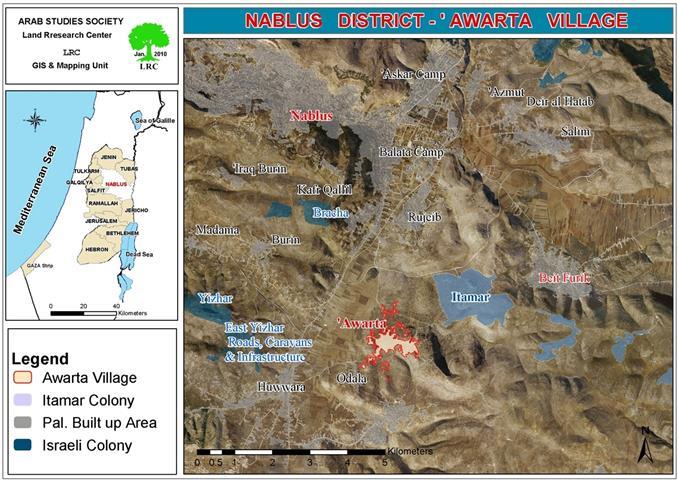
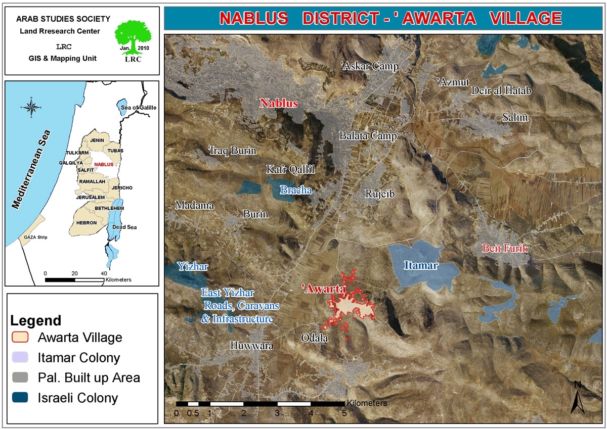
Location:  Parcel 3, Al M’alaqa region, ‘Awarta village.


Violators: the Israeli Occupation Army.
Victims: ‘Awarta villagers.
 
Details:
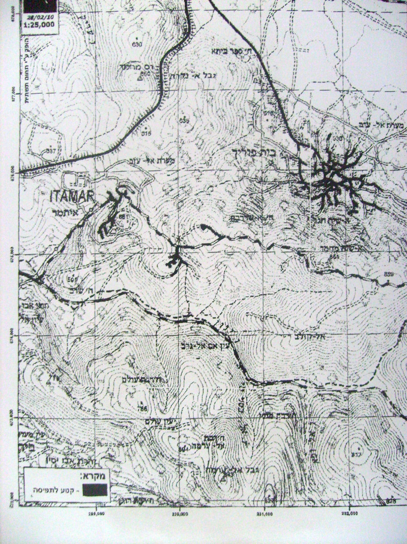
On March 28, 2010, the Israeli Occupation Army handed ‘Awarta Village Council a confiscation order (number T/12/10). The purpose of the land grab is military; the area will be designated for constructing a guard tower and a path leading to the tower.
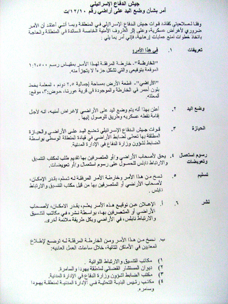


Picture 1+2: the confiscation order
 
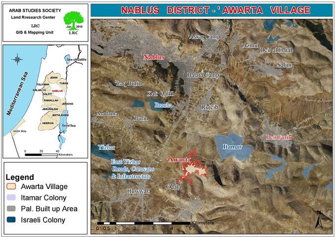
The order, if carried out, is considered extremely dangerous. The designated area is 3 km away from the nearby Etmar colony, and 5 km away from ‘Awarta village. The land is located in the middle of hundreds of extremely fertile lands that the Israelis have disallowed the Palestinians to exploit for years for the sake of ‘Etmar security’. The locals fear that this is a prior step towards expropriating the whole area.
 
Amjad Darawsha, 32, a member of ‘Awarta village Council board stated to an LRC observer:’ since the beginning of the second Intifada, the colonists have escalated their aggressions against the Palestinians using any available method. The Israeli Occupation Army announced that the area is a ‘military zone’ ten years ago. None of the locals was able to reach their lands except a few who were able to get extremely limited permits allowing them to get there in very special occasions.
 
Although, some of the villagers were able to obtain permits during the most recent olive-picking season, they were not spared. Certainly, the existence of the Israeli Occupation there is useless when the Palestinians are harmed. 
 
On March 22, 2010, two Palestinian young men were executed in cold blood by Israeli soldiers. The victims, Salah and Mohammad Qawariq, were shot few meters away from the area mentioned in the military order. This is a clear evidence of the Israeli Army brutality and the way soldiers treat Palestinians. Knowingly, the order was issued in parallel with the executions, which was provocative to the mourning residents.
 
This order is nothing but a step towards taking over more land. It is known that 12 out of 23 thousand dunums of the village total area were confiscated since the establishment of Etmar colony’.
 
‘Awarta…suffering:
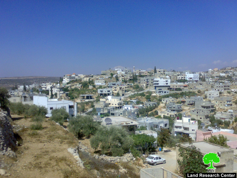
‘Awarta is located 6 km away from Nablus city, its total population is 6000 people excluding the ones who immigrated in 1948 and 1967. ‘Awarta states a clear evidence of the Palestinian agony, its inhabitants suffer from continuous harassments by the Israeli Occupation soldiers positioned in Huwwara military base.
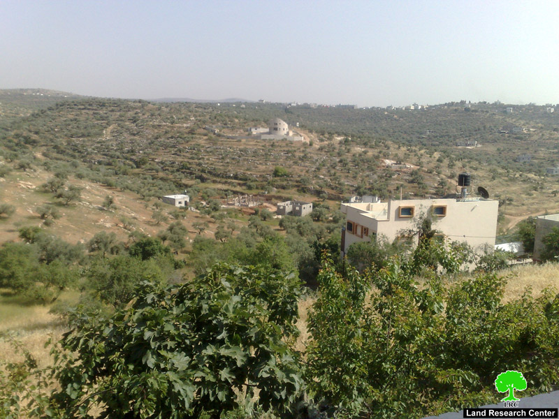
 
 
Picture 3+4: ‘Awarta village
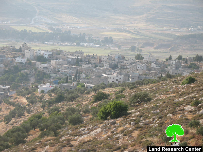
 
 
Picture 5: ‘Awarta and Huwwara military base
 

Recently, Israeli colonists have been repeatedly breaking into the village under the protection of the Israeli Army especially during the early hours of almost every day.
 
The colonists claim that they are visiting cultural sites; however, it is clear in the eye of the beholder that their claims are false and they are nothing near the truth. The Quran verses inscribed on the walls of these sites provide apparent and undisputed evidence that these sites are not Jewish and have never been.
 
Nevertheless, this never stopped the colonists from showing up in the village every once and while, restraining movement, bullying and harassing the residents, sabotaging property, etc.
 
‘Awarta witnessed another catastrophe (Nakba) in 1984 when Etmar was established. The colony is considered a barrier that separated Nablus city and the surrounding villages from the Jordan valley area.


Picture 6: parts of Etmar, the caravans are spread randomly
to take over as much Palestinian land as possible.
 
During 1984, the corner stone of the colony was put in place by a group of Me’er school student. At first, it was called ‘Tal Haim’; the purpose of establishing the colony was reestablishing the ‘Jewish life style’ in the location considered ‘a religious symbol’ relating it to the ’70 ancestors’ according to Jewish historians. Soon afterwards, the colony started expanding, multiplying its area many times and changing its name to Etmar.  Ehud Barak, the former Israeli Prime Minister announced multiplying the colony’s area ten times in 2000, placing the corner stone himself.
 
His plan was constructing a massive colonies line to the east of Nablus that passes near the Palestinian villages in the area and expanding towards the Jordan valley region, covering tens of thousands of dunums.  Etmar is now very close to Huwwara military base and connected to it by a by-pass road. It is also connected to Alon Moreh colony through the same road.
 
The colony and the surrounding colonies are all connected through by-pass roads network. The whole entity is included in the Israeli plans as part of the ‘Israeli Jewish state’. In ‘Awarta, the colony expands from Huwwara military camp to the west to ‘Khallit al ‘Adas’ to the west, 6600 meters long. In addition, it expands to the borders of Rujib and Beit Furiq, about 1500 meters wide. The total area of the colony is 12000 dunums.
 
Etmar colony name is widely connected to many horrific events, in addition to the most recent executions of Mohammad (19) and Salah Qawariq (19), many violations were recorded including, burning trees and crops, land grab, burglary of crop and herds, random shooting at Palestinian houses by the Israeli Army and colonists, and brutally beating whoever tries to plow or work in his land. As a result, hundreds of Palestinians were killed, injured, or taken into custody.


  Prepared by
The Land Research Center
LRC

Recommended For You

” 118 ألف دونم مهددة بالعزل في محافظة طوباس”
إسرائيل تستكمل مشروع “الخط القرمزي” وتوسع عزل الأراضي الفلسطينية شرق الضفة الغربية المحتلة

by arij
July 29, 2026
0
” 118 ألف دونم مهددة بالعزل في محافظة طوباس”  إسرائيل تستكمل مشروع “الخط القرمزي” وتوسع عزل الأراضي الفلسطينية شرق الضفة الغربية المحتلة

  بعد مرور تسعة أشهر على إصدار سلطات الاحتلال الإسرائيلي مجموعة من الأوامر العسكرية التي استهدفت إنشاء ما أصبح يُعرف بين الفلسطينيين بـ “الخط القرمزي" في منطقة الأغوار...

Read moreDetails

الاحتلال الاسرائيلي يوسع سيطرته على أراضي جبل الفرديس بمصادرة 317 دونم اخرى

by arij
June 15, 2026
0
الاحتلال الاسرائيلي يوسع سيطرته على أراضي جبل الفرديس بمصادرة 317 دونم اخرى

  في الخامس والعشرين من شهر ايار من العام 2026 نشرط سلطات الاحتلال الاسرائيلي امرا عسكريا جديدا يحمل اسم "أمر بشأن قانون الأراضي استملاك للمصلحة العامة) (يهودا والسامرة)...

Read moreDetails

بواقع 19 دونما – سلسلة من الأوامر العسكري الإسرائيلي تستهدف أراضي محافظة بيت لحم بذريعة الأغراض العسكرية

by arij
June 13, 2026
0
بواقع 19 دونما – سلسلة من الأوامر العسكري الإسرائيلي تستهدف أراضي محافظة بيت لحم بذريعة الأغراض العسكرية

سلمت سلطات الاحتلال الإسرائيلي أهالي محافظة بيت لحم سلسلة من الأوامر العسكرية لمصادرة مساحات شاسعة من الأراضي الفلسطينية في المحافظة بذريعة أغراض عسكرية. واستهدفت الأوامر العسكرية الجديدة عددا...

Read moreDetails

بمساحة اجمالية بلغت 208 دونما – سلطات الاحتلال الإسرائيلي تصادر الاراضي في محافظة طوباس لصالح معسكر اسرائيلي

by arij
June 13, 2026
0
بمساحة اجمالية بلغت 208 دونما – سلطات الاحتلال الإسرائيلي تصادر الاراضي في محافظة طوباس لصالح معسكر اسرائيلي

سلّمت سلطات الاحتلال الإسرائيلي، في السابع من حزيران 2026، أهالي مدينة طوباس شمال الضفة الغربية المحتلة أمراً عسكرياً جديداً بعنوان: "أمر بشأن وضع اليد على أراضٍ رقم 79/26/ت...

Read moreDetails

الاحتلال يرسّخ بؤرة “يتسيف” الاستيطانية عبر تخصيص 92 دونماً من أراضي بيت ساحور

by arij
June 9, 2026
0
الاحتلال يرسّخ بؤرة “يتسيف” الاستيطانية عبر تخصيص 92 دونماً من أراضي بيت ساحور

أصدر جيش الاحتلال الإسرائيلي في الخامس من شهر اذار من العام 2026 إعلاناً عسكرياً جديداً موقع من قبل ما يُسمّى بـ “قائد قوات جيش الدفاع الإسرائيلي في منطقة...

Read moreDetails
Next Post
إخطارات بمصادرة أراضي لاغراض عسكرية في قرية عورتا

إخطارات بمصادرة أراضي لاغراض عسكرية في قرية عورتا

LATEST NEWS

” 118 ألف دونم مهددة بالعزل في محافظة طوباس”  إسرائيل تستكمل مشروع “الخط القرمزي” وتوسع عزل الأراضي الفلسطينية شرق الضفة الغربية المحتلة

” 118 ألف دونم مهددة بالعزل في محافظة طوباس”
إسرائيل تستكمل مشروع “الخط القرمزي” وتوسع عزل الأراضي الفلسطينية شرق الضفة الغربية المحتلة

by arij
July 29, 2026
0

........................................................

إقرار مخطط توسعي رئيسي في مستوطنة تقوع شرق بيت لحم

إقرار مخطط توسعي رئيسي في مستوطنة تقوع شرق بيت لحم

by arij
July 28, 2026
0

........................................................

تستهدف 6000 دونما من الأراضي الفلسطينية وشرعنة ستة مستوطنات جديدة  إقرار مخططات توسعة رئيسية في تجمع غوش عتصيون الاستيطاني جنوب الضفة الغربية المحتلة

تستهدف 6000 دونما من الأراضي الفلسطينية وشرعنة ستة مستوطنات جديدة
إقرار مخططات توسعة رئيسية في تجمع غوش عتصيون الاستيطاني جنوب الضفة الغربية المحتلة

by arij
July 22, 2026
0

........................................................

“حتى النصف الأول من العام 2026 “, ” الاستيطان يلتهم الأرض الفلسطينية: ما يزيد عن 22 ألف دونم مستهدفة و 19 ألف وحدة استيطانية”

“حتى النصف الأول من العام 2026 “, ” الاستيطان يلتهم الأرض الفلسطينية: ما يزيد عن 22 ألف دونم مستهدفة و 19 ألف وحدة استيطانية”

by arij
July 22, 2026
0

........................................................

flag_yellow_lowEU-PfP-Logo

This website and its content were initiated in 1993 by the Applied Research Institute – Jerusalem (ARIJ) and the Land Research Center (LRC) with the support from the European Union up until 2023. Since then, the Applied Research Institute – Jerusalem (ARIJ) has taken over the continued development and maintenance of the website. The views expressed remain solely those of ARIJ) and do not necessarily reflect those of the European Union.

© 2026 Copyright | ARIJ | All Rights reserved.

No Result
View All Result
  • Home
  • Settlements
    • New Israeli Settlements
    • Settlement Expansion
  • Israeli Violations
    • Agriculture
    • Confiscation
    • Demolition
    • Environment
    • Eviction of Palestinians
    • Settlers Attacks
  • Bypass Roads
  • Israeli Plans
  • Segregation
    • Checkpoints
    • Closure
    • Separation Plans
  • Military Orders
  • Reports
    • Daily Report
    • Monthly Report
    • Quarterly Report

© 2026 Copyright | ARIJ | All Rights reserved.