• About The Project
  • Palestine in Century
  • Selected Maps
  • Glossary
  • About ARIJ
  • About LRC
  • By Year
    • Case Studies By Year
    • Daily Report By Year
Sunday, June 7, 2026
POICA
No Result
View All Result
  • Home
  • Settlements
    • New Israeli Settlements
    • Settlement Expansion
  • Israeli Violations
    • Agriculture
    • Confiscation
    • Demolition
    • Environment
    • Eviction of Palestinians
    • Settlers Attacks
  • Bypass Roads
  • Israeli Plans
  • Segregation
    • Checkpoints
    • Closure
    • Separation Plans
  • Military Orders
  • Reports
    • Daily Report
    • Monthly Report
    • Quarterly Report
No Result
View All Result
POICA
No Result
View All Result

Demolition Orders against 11 Palestinian Residences in Silwan

March 8, 2010
in Military Orders
Demolition Orders against 11 Palestinian Residences in Silwan


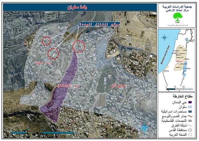
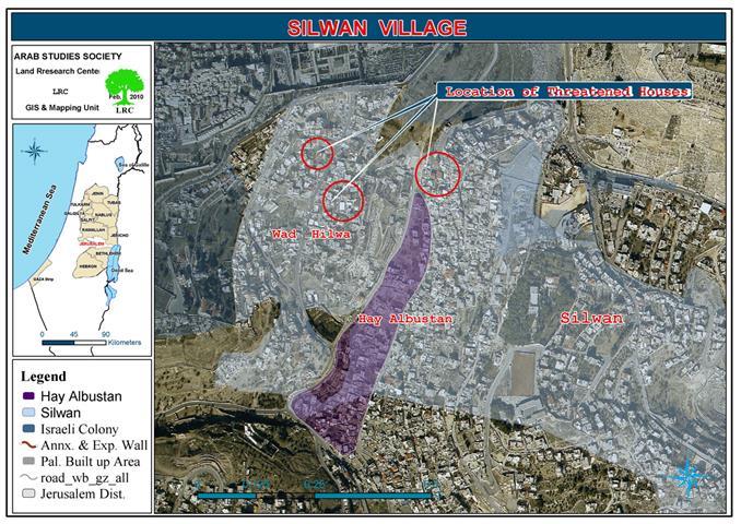
Picture 1: Threatened houses sites

 
Violation: issuing demolition orders against 11 Palestinian structures.
Location: Al ‘Abassiya neighborhood, Silwan, the Occupied City of Jerusalem.
Date: February 24, 2010.
 
Violators: Israeli Occupation Police, Israeli Occupation Border Police, Israeli Occupation Special Forces, and the Jewish Municipality in the Occupied City.
Victims: Al ‘Abbasi, Alshyoukhi, Alsalfiti, Alhaymoni, ‘Alqam, Miswada, Ghanim, Alsalayma, and Attawil families.
 

Picture 2: the demolition order issued against Palestinian
structures by the Jewish Municipality in Jerusalem
 
Introduction:
Residents of Al Bustan and Al ‘Abassiya neighborhoods in Silwan are living through constant nervousness and fear because of the Jewish Municipality in the Occupied City of Jerusalem decision that called for evacuating and demolishing 100 Palestinian houses that are inhabited by 140 Palestinian families.
 
1000 Palestinians are about to be homeless because of the plan put by the Municipality back in the 1970’s and is about to be implemented. Most of the houses included in the unjust Israeli plan were built even before the rise of the ‘State of Israel’ in 1948 and long before the Occupation of the West Bank including Jerusalem. In addition, some of the houses included in the colonial plan are 10 to 15 years old.
 
Details:
At 7:30 on February 24, 2010, more than 30 armed Israelis accompanied by some Municipality employees showed up in Silwan. The Israeli Occupation Police started distributing demolition orders either by sticking them on the houses gates or by breaking into the houses.
 
 
Picture 3: an overview of Silwan
 
More than 100 Palestinians are about to be deported:
The most recent demolition orders were issued against 11 Palestinian houses, if they were implemented, more than 100 Palestinians will become dispossessed. Riyad Attawil, one of the victims, stated to an LRC observer:’ at 7:30 in the morning, a group of the Israeli Occupation Police, Border Police, and Special Forces broke into my house. I was shocked to see those taking pictures and measuring the house. It must be known that the house and the storage were built in 1961 and that we have a valid construction permit that was issued by the Jordanian Municipality in Jerusalem. The permit is dated May26, 1962. 5 families that consist of 18 members are currently residing in the house’.
 
Picture 4: Attawil residence construction permit (issued in 1963)
Picture 5: Attawil residence schematics 
 
The Target is Silwan as a whole, not only Al Bustan Neighborhood:
It has never happened that the Israeli Occupation Authorities issue such a large number of demolition orders in Wadi Hilwa and Al Bustan Neighborhoods in Silwan. This makes it clear that the Israelis are targeting the whole town and not only a certain area. The plan of constructing’a Jewish National Park’ in the Occupied City of Jerusalem cover the area starting from Gethsemane Church through Tantor Pharaoh and Al ‘Ein area to Wad al Rababa and Bir Ayyub areas covering the whole Al Bustan Neighborhood.
 
As for Wadi Hilwa Street, no traffic will be allowed there and the street will be paved likewise Ras al Bustan Street to the west of Silwan. All of these changes are part of the ‘Sacred Torah Parcel’ plan which is a prior step to controlling the surroundings of the Old City in order to take control of it.
 
The Israeli Occupation Government decisions of naming the Ibrahimi Mosque in Hebron and Bilal Mosqe in Bethlehem Jewish cultural places is part of the Israeli expansion plans by using power to set facts on the ground, the power of occupation that is condemned by the Geneva Fourth Pack.
 
 
Picture 6: theMunicipality plan ofbuilding a park in Silwan
 

Picture 7: paving Ras al Bustan Street in order to turn it into a tourist site


Prepared by
The Land Research Center
LRC
 

Recommended For You

سلطات الاحتلال الإسرائيلي بصدد الاستيلاء على موقع قبر النبي صموئيل شمال غرب مدينة القدس

by arij
May 23, 2026
0
سلطات الاحتلال الإسرائيلي بصدد الاستيلاء على موقع قبر النبي صموئيل شمال غرب مدينة القدس

 نشرت سلطات الاحتلال الإسرائيلي في الثامن عشر من شهر أيار من العام 2026 اعلانا مفاده الاستيلاء على الأراضي الفلسطينية في قرية النبي صموئيل شمال غرب القدس المحتلة. وجاء...

Read moreDetails

إقامة منطقة عسكرية عسكرية داخل أراضي (أ) في جنين

by arij
May 19, 2026
0
إقامة منطقة عسكرية عسكرية داخل أراضي (أ) في جنين

   في السابع من شهر أيار من العام 2026، وزعت سلطات الاحتلال الإسرائيلي أمرا عسكريا جديدة على أهالي مدينة جنين يقضي بمصادرة 7.2 دونما من الأراضي الفلسطينية في...

Read moreDetails

“بمساحة اجمالية 177 دونما من أرضي البيرة وبيتين”, طريق استيطاني لخدمة البؤر الاستيطانية في محافظة رام الله

by arij
May 18, 2026
0
“بمساحة اجمالية 177 دونما من أرضي البيرة وبيتين”, طريق استيطاني لخدمة البؤر الاستيطانية في محافظة رام الله

في الحادي عشر من شهر أيار من العام 2026, نشرت دائرة أراضي إسرائيل اعلانا جديدا يقضي بمصادرة المزيد من الأراضي الفلسطينية في محافظة رام الله لأغراض استيطانية في...

Read moreDetails

“في خدمة مستوطنة ناحال حيلتس”, طريق استيطاني إسرائيلي جديد على أراضي بتير وبيت جالا في محافظة بيت لحم

by arij
May 18, 2026
0
“في خدمة مستوطنة ناحال حيلتس”, طريق استيطاني إسرائيلي جديد على أراضي بتير وبيت جالا في محافظة بيت لحم

تواصل سلطات الاحتلال الإسرائيلي إحكام سيطرتها على المزيد من الأراضي الفلسطينية في الضفة الغربية المحتلة، وهذه المرة من خلال استهداف أراضي محافظة بيت لحم. ففي السادس والعشرين من...

Read moreDetails

مناطق نفوذ المستوطنات ودورها في إعادة تشكيل الجغرافيا الفلسطينية

by arij
April 23, 2026
0
مناطق نفوذ المستوطنات ودورها في إعادة تشكيل الجغرافيا الفلسطينية

أصدرت سلطات الاحتلال الإسرائيلي في العاشر من شهر نيسان 2026 الكراسة رقم (273)، وهي وثيقة تضم مجموعة من المناشير والأوامر والتعيينات الإسرائيلية المتعلقة بالجوانب الأمنية والعسكرية والإدارية، إضافة...

Read moreDetails
Next Post
إخطارات بإخلاء وهدم 11 مسكناً فلسطينياً في سلوان

إخطارات بإخلاء وهدم 11 مسكناً فلسطينياً في سلوان

LATEST NEWS

سلطات الاحتلال الإسرائيلي بصدد الاستيلاء على موقع قبر النبي صموئيل شمال غرب مدينة القدس

سلطات الاحتلال الإسرائيلي بصدد الاستيلاء على موقع قبر النبي صموئيل شمال غرب مدينة القدس

by arij
May 23, 2026
0

........................................................

إقامة منطقة عسكرية عسكرية داخل أراضي (أ) في جنين

إقامة منطقة عسكرية عسكرية داخل أراضي (أ) في جنين

by arij
May 19, 2026
0

........................................................

الآثار كأداة للضم الزاحف: مشروع القانون الإسرائيلي لإعادة هندسة الجغرافيا والهوية في الضفة الغربية

الآثار كأداة للضم الزاحف: مشروع القانون الإسرائيلي لإعادة هندسة الجغرافيا والهوية في الضفة الغربية

by arij
May 23, 2026
0

........................................................

النكبة الفلسطينية في ذكراها الثامنة والسبعين: من التطهير العرقي إلى الإبادة وإعادة هندسة الجغرافيا الفلسطينية 

النكبة الفلسطينية في ذكراها الثامنة والسبعين: من التطهير العرقي إلى الإبادة وإعادة هندسة الجغرافيا الفلسطينية 

by arij
May 18, 2026
0

........................................................

flag_yellow_lowEU-PfP-Logo

This website and its content were initiated in 1993 by the Applied Research Institute – Jerusalem (ARIJ) and the Land Research Center (LRC) with the support from the European Union up until 2023. Since then, the Applied Research Institute – Jerusalem (ARIJ) has taken over the continued development and maintenance of the website. The views expressed remain solely those of ARIJ) and do not necessarily reflect those of the European Union.

© 2026 Copyright | ARIJ | All Rights reserved.

No Result
View All Result
  • Home
  • Settlements
    • New Israeli Settlements
    • Settlement Expansion
  • Israeli Violations
    • Agriculture
    • Confiscation
    • Demolition
    • Environment
    • Eviction of Palestinians
    • Settlers Attacks
  • Bypass Roads
  • Israeli Plans
  • Segregation
    • Checkpoints
    • Closure
    • Separation Plans
  • Military Orders
  • Reports
    • Daily Report
    • Monthly Report
    • Quarterly Report

© 2026 Copyright | ARIJ | All Rights reserved.