
In the aftermath of the success of the Israeli right wing parties in the latest elections led by Benjamin Netaniyahoo settlement activities have intensified, especially inside the existing colonies spread all over the West Bank territories. This has been the case in the colony of Revava in Salfit district which was established in 1991 over the land of Dei Istiya village, basin number 7, with a total population of 989 by the end of 2007 and municipal boundaries of 1540 dunums of which 160 as built up area (source: Foundation for the Middle East Peace).
( Map 1)
Ever since its initiation the colony has been blocking the natural expansion of the nearby Deir Istiay village and cutting the agricultural and postural area of this village which had a population of 4500 by the end of 2008 and a total land area of 34592 dunums of which 781 dunums as built up area (source: Palestinian central Bureau for Statistics)
The ongoing expansionist activities of the Revava colony include the building of houses, erection of mobile homes ( caravans), opening of roads, constructing of a synagogue and a 'security ring road' and fences. These activities are supervised by the supreme council of the Jewish settlement in the West Bank and are being done at the expense of the Deit Istya land.
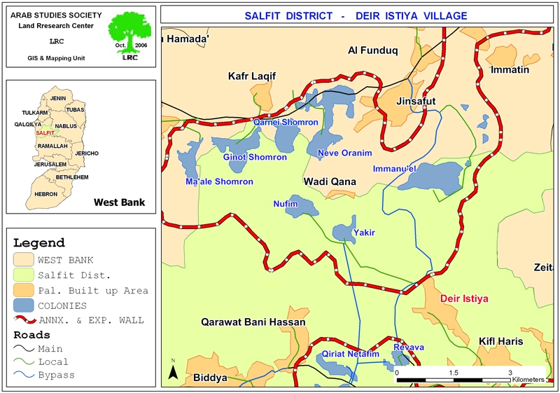
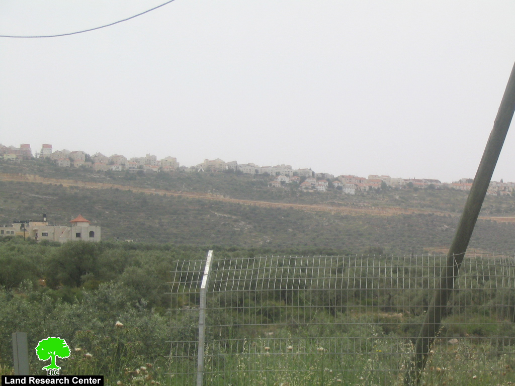
(Photo 1: A general view of Revava colony and the under construction
synagogue pointed at by red arrow )
New security built
As part of the expansion activities Israeli bulldozers are working on the opening of a new ring road out side the limits of the previous one under the pretext of building a security built the main purpose of which is to confiscate and annex hundreds of dunums to the colony. The target land of this apartheid project is the land of Deir Istya, Haris and Kifl Haris villages which has been cultivated with seasonal ground crops.
Haj Ma'mun Mohammed Daood, 76 years old, from Haris village owns 32 dunums in Wadi Ash Shami which are located about two km to the west of the village next to the colony of Revava. They are cultivated with olive trees and ground crops and very well tended. However, in September, 2008, Haj Ma'mun was badly beaten at the hands of Revava settlers whilst tending his land and he was hospitalized. He was, also, beaten at the beginning of 2006 when he objected the construction of a colonial road in his land by Revava settlers. Speaking to LRC field researcher, Haj Ma'mun said the following: ' In 2006 a case was levied with an Israeli court against the settlers who destroyed my land to build a road. Later on, an Israeli court decided to return the land to me and close the road. However, the settlers continued their attacks by repeatedly destroying my trees and crops and, even, beat me as what happened in September last year. The latest action was the re-occupation of my land and re-opening of the road that was closed by a decision issued by an Israeli court. This shows that the settlers are above the law and they are supported by the Israeli security and judicial system'.
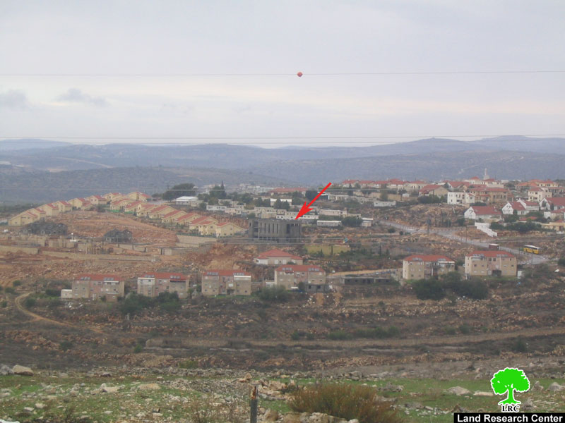
( Photo 2: swage water from Revava colony contaminating Al Wadi ash Shamali)
Additional infrastructure works
Since the beginning of April, 2009 the Israeli occupation authorities have indulged in the construction of new roads and high voltage power lines to link the colony of Revava with the other seven colonies built in and around Wadi Qana area in central Salfit district. These colonies are: Nofim, Yakir, Karne Shomron, Ginat Shomroan, Nof Oramin, Ma'ale Shomron and Immanuel.
Israeli colonies in Salfit governorate:
When comparing the Governorate of Salfit with the rest of the Palestinian governorates, we find that it is exceptional in the high number of Israeli colonies on its soil. So far, there are 17 existing Israeli colonies which occupy not less than 38134 dunums (38.1 km2) or 18.6% of the total area of the district of Salfit. This figure includes about 8835 dunums (8.8 km2) of built up area which constitutes 4.3% of the total surface area of the Governorate (Source: Field Work and GIS Unit at LRC; Foundation for Middle East Peace)
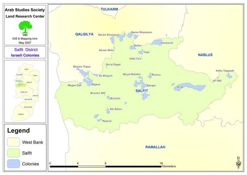
( Map 2)
The number of Israeli colonists in the Governorate in 2005 (according to the Foundation for Middle East Peace) was around 40 000, constituting about 8.8% of the total number of colonists in the West Bank and East Jerusalem and around 20% of the colonists in the West Bank alone.
The Israeli colonies started to be built in the Governorate in 1977 when the colony of Elkana was established atop the ruins of a Jordanian Army Camp in the area of Jabal Al Hilo in the village of Masha. Some of these colonies are in nature residential and industrial, while some of them are multi-purpose such as Ariel colony which is used for residential as well as religious, educational and industrial purposes.
The colony of Ariel is the largest colony in the Governorate of Salfit as Israeli occupation authorities dubbed it the capital of Samaria. It was established in 1978 on the eve of signing the Camp David Accords between Egypt and Israel. The initial step of its establishment was the confiscation of 500 dunums from the lands of the city of Salfit and the village of Marda only to be enlarged to its current municipal area of 13775 dunums confiscated from the villages of Marda, Kifel Haris, Iskaka in addition to the City of Salfit. In 1998, during the premiership of Bibi Netanyahu, the colony was transformed into a city that had a college, a number of factories and industries, hotels in addition to a large population. In accordance with the 2005 population estimates, the number of colonists in Ariel is around 16520 (Source: ibid).
( photo 3: The northern extremity of Ariel colony ovelooking the Palestinian village of Marda )
Table (1): Israeli colonies by name, surface area and population in Salfit Governorate
|
Colony |
Type |
Date of Estab. |
Built up area Dunum |
Municipal area Dunum |
Population as of 2005 |
Principal Palestinian nearby locality |
|
Ariel |
Residential Educational Military Industrial |
1978 |
2479 |
13775 |
16520 |
Salfit,kifl Haris, Mrada, Iskaka |
|
Emmanuel |
Residential |
1982 |
328 |
1909 |
2583 |
Deir Istya |
|
Yakir |
Residential |
1981 |
342 |
1364 |
984 |
Deir Istya |
|
Novim |
Residential |
Un-available |
248 |
331 |
400 |
Deit Istya |
|
Karne Shomron |
Residential and industrial |
1978 |
1351 |
7339 |
6280 |
Deir Istya |
|
Ma'ale Shomron |
Residential |
1980 |
216 |
1903 |
574 |
Deir Istya |
|
Ginot Shomron |
Residential |
1985 |
608 |
UA |
UA |
Deir Istya |
|
Revava |
Residential |
1991 |
160 |
1540 |
827 |
Haris |
|
Kfar Tapuah |
Residential and military |
1978 |
156 |
414 |
648 |
Yasuf |
|
Pedu'el |
Residential |
1984 |
171 |
595 |
1113 |
Kurf Al Diek and Beir Balooot |
|
Qiryat Netafim |
Residential |
1982 |
162 |
1540 |
438 |
Qarawa, Haris |
|
Alei Zahav |
Residential |
1982 |
255 |
2003 |
684 |
Kufr Al diek |
|
Elkana |
Residential |
1977 |
758 |
1198 |
2963 |
Masha |
|
Sha'are Tikva |
Residential |
1982 |
915 |
1045 |
3709 |
Masha, Azzun Al Atma |
|
Etz Efrayim |
Residential |
1985 |
184 |
458 |
642 |
Masha, Beit Amin, Sneirya |
|
Barkan |
Residential and Industrial |
1981 |
349 |
2720 |
1231 |
Sarta, Broqein, Haris |
|
Neve Oranim |
Residential |
1991 |
153 |
NA |
NA |
Parts of Beit Istiya. |
|
Total |
8835 |
38134 |
39596 |
|
||
Sources:
- Field Work and GIS Unit at LRC;
- Foundation For Middle East Peace – Washington DC.
Related case studies published on www.poica.org:
2- New Land confiscation Order in Deir Istya Village – Salfit Governorate, 08,October,2006.
3- The colonialization onslaught is going on against the village of Deir Istya,10,March,2005
Prepared by:
The Land Research Center
LRC


