• About The Project
  • Palestine in Century
  • Selected Maps
  • Glossary
  • About ARIJ
  • About LRC
  • By Year
    • Case Studies By Year
    • Daily Report By Year
Saturday, March 28, 2026
POICA
No Result
View All Result
  • Home
  • Settlements
    • New Israeli Settlements
    • Settlement Expansion
  • Israeli Violations
    • Agriculture
    • Confiscation
    • Demolition
    • Environment
    • Eviction of Palestinians
    • Settlers Attacks
  • Bypass Roads
  • Israeli Plans
  • Segregation
    • Checkpoints
    • Closure
    • Separation Plans
  • Military Orders
  • Reports
    • Daily Report
    • Monthly Report
    • Quarterly Report
No Result
View All Result
POICA
No Result
View All Result

Israeli Settlers Pursue Geographical Contiguity between settlements

May 7, 2009
in Settlement Expansion
Israeli Settlers Pursue Geographical Contiguity between settlements

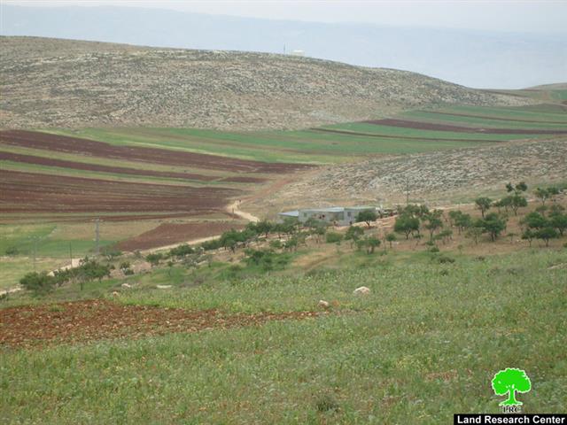
On May 4, 2009, an Israeli settler from the nearby Illegal Israeli settlement outpost of Derech Ha’avot located north of El'azar settlement southwest of Bethlehem city ran over an adjacent Palestinian land in an attempt to construct a new bypass road in the area. The settler razed almost ten dunums of land and damaged more than 150 dunums of lands in the vicinity when he drove his bulldozer over the lands crushing fruitful trees (almond trees, grapevines and other plants). The targeted lands, which are privately owned by several families from Al Khader village, are located in Abu Bkeir area, alongside the Israeli controlled bypass Road number 60.

The razed lands showed that the settler was trying to construct a new bypass road (0.65 km long) that will abridge the access way of the outpost's settlers to the Israeli bypass road number 60 instead of having to go around for 1.25 km.


Photo 1 & Photo 2: The razed liands in Al Khader Village


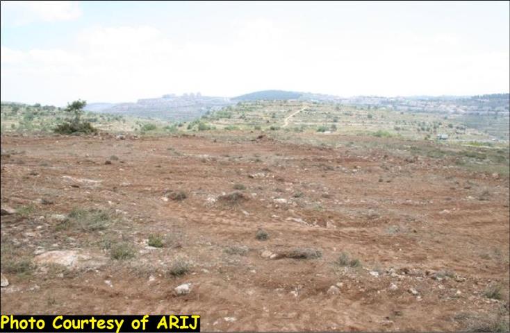
The Derech Ha'avot outpost or Netiv Ha'avot – Jabal Habun was established in February 2001. It is located in close parameters of El'azar settlement southwest of Bethlehem city. Today, the outpost has 9 permanent structures and 25 trailers inhabited by 56 Israeli settlers. (Source: ARIJ GIS Database, 2007). See map & photo of the outpost:

Photo 3: An Over View of Derech Ha’avot Outpost


Map 1: The projected Israeli road


Al Khader Village

The village is located 4.5 kilometers west of Bethlehem city with a population of 11,233 inhabitants, PCBS 2008. It may be accessed via Beit Jala or the Bethlehem-Hebron Road. Through the decades of Israeli occupation, more than 50% of the town's lands were confiscated to construct settlements and by-pass roads. Today, the town also faces the threat of the Segregation Wall that runs along the northern and western parts of Al-Khader town, and consequently will cut of areas of Al-Khader where the settlements where constructed and an additional cultivated land, which will be isolated behind the Segregation Wall denying the residents access to considerable areas (8400 Dunums (42% of the village total area), including agricultural lands (87%, 6000 Dunums of the total agricultural lands in the village). The southern area of Al-Khader village is also blocked by the continues expansion of Efrat settlement, by which the only available land available for Al-Khader to cope with future population growth are located at the western parts of the village where the residents will have to use their whatever remains of the agricultural lands for construction.

To Conclude

The Israeli building of the settlements and their outpost, bypass roads is illegal and violates the International law, rules, and conventions.

  • Article 147 of the Fourth Geneva Convention indicated that: Extensive destruction and appropriation of property not justified by military necessity and carried out unlawfully and wantonly, is a grave breach of the Convention.

  • Oslo Agreement (The interim agreement of 1995), article1, item 2 and 4 clearly state (… the unity and integrity of the Palestinian people in the West Bank and Gaza Strip shall be maintained and respected…). The ''Lateral Roads'', or what people call ''bypass roads'' -because they are meant to circumvent (i.e. bypass) Palestinian built up areas, are now disconnecting Palestinian communities from each other.


Prepared by:
The Applied Research Institute – Jerusalem

Recommended For You

على ما مساحته 1006.4 دونما من أراضي بلدة يانون
“سلطات الاحتلال الإسرائيلي تشرع بتغيير نفوذ بؤرة استيطانية في الضفة الغربية المحتلة”

by arij
March 14, 2026
0
على ما مساحته 1006.4 دونما من أراضي بلدة يانون  “سلطات الاحتلال الإسرائيلي تشرع بتغيير نفوذ بؤرة استيطانية في الضفة الغربية المحتلة”

في الثاني عشر من شهر شباط من العام 2026, نشر رئيس قسم الاستيطان والتنظيم فيما يسمى "بالإدارة المدنية الإسرائيلية", الذراع الأيمن لحكومة الاحتلال الإسرائيلية اعلانا مفاده " اعلان...

Read moreDetails

حين تتقلص الخريطة: تسارع غير مسبوق في توسّع المستوطنات الإسرائيلية خلال عام 2025

by arij
February 16, 2026
0
حين تتقلص الخريطة: تسارع غير مسبوق في توسّع المستوطنات الإسرائيلية خلال عام 2025

مقدمة: - ان السياسة الاستيطانية الإسرائيلية في الضفة الغربية المحتلة هي واحدة من أكثر القضايا التي تقف عائقا في تحقيق سلام عادل وقابل للحياة في الأراضي الفلسطينية المحتلة....

Read moreDetails

حين يصبح الاستيطان سياسة دولة: 26 ألف وحدة جديدة تهدد الضفة الغربية

by arij
November 27, 2025
0
حين يصبح الاستيطان سياسة دولة: 26 ألف وحدة جديدة تهدد الضفة الغربية

في ظلّ صمتٍ دوليٍّ متزايد، يكشف معهد الأبحاث التطبيقية – القدس (أريج) عن طرح سلطات الاحتلال الإسرائيلي مخططات بناء استيطانية لأكثر من 26 ألف وحدة استيطانية جديدة في...

Read moreDetails

Expansion of Gilo Settlement: A Strategic Plan to Isolate Bethlehem and Undermine Palestinian Rights

by arij
May 12, 2025
0
Expansion of Gilo Settlement: A Strategic Plan to Isolate Bethlehem and Undermine Palestinian Rights

The Israeli Civil Administration has announced a new settlement expansion plan—No. 101-1284223—which outlines the construction of 1,990 new settlement units on approximately 175.9 dunums of land extending towards...

Read moreDetails

إسرائيل تمضي قدمًا في مخطط استيطاني جديد على أراضي مدينة بيت جالا، في انتهاك للقانون الدولي وحرمان الفلسطينيين من أراضيهم

by arij
April 29, 2025
0
Israel Advances Settlement Plan on Ancient Olive Groves on lands of Beit Jala city, Violating International Law and depriving Palestinians their lands

  في أواخر شهر شباط من العام 2025، صادقت دولة الاحتلال الإسرائيلي على مخطط استيطاني جديدة لبناء حي سكني للمستوطنين على مساحة 22.2 دونما من الأراضي الفلسطينية لتابعة...

Read moreDetails
Next Post
Residential and agricultural buildings demolished in Khirbet at Tawil

Residential and agricultural buildings demolished in Khirbet at Tawil

LATEST NEWS

سلطات الاحتلال الإسرائيلي تستهدف قرية الجيب بأمر عسكري جديد

سلطات الاحتلال الإسرائيلي تستهدف قرية الجيب بأمر عسكري جديد

by arij
March 17, 2026
0

........................................................

على ما مساحته 1006.4 دونما من أراضي بلدة يانون  “سلطات الاحتلال الإسرائيلي تشرع بتغيير نفوذ بؤرة استيطانية في الضفة الغربية المحتلة”

على ما مساحته 1006.4 دونما من أراضي بلدة يانون
“سلطات الاحتلال الإسرائيلي تشرع بتغيير نفوذ بؤرة استيطانية في الضفة الغربية المحتلة”

by arij
March 14, 2026
0

........................................................

الاحتلال الإسرائيلي يستهدف مشاريع تنموية في قرية جورة الشمعة جنوب شرق بيت لحم

الاحتلال الإسرائيلي يستهدف مشاريع تنموية في قرية جورة الشمعة جنوب شرق بيت لحم

by arij
March 14, 2026
0

........................................................

سلطات الاحتلال الإسرائيلي تستخدم الأوامر العسكرية لتعمق المشروع الاستيطاني في الضفة الغربية المحتلة

سلطات الاحتلال الإسرائيلي تستخدم الأوامر العسكرية لتعمق المشروع الاستيطاني في الضفة الغربية المحتلة

by arij
February 26, 2026
0

........................................................

flag_yellow_lowEU-PfP-Logo

This website and its content were initiated in 1993 by the Applied Research Institute – Jerusalem (ARIJ) and the Land Research Center (LRC) with the support from the European Union up until 2023. Since then, the Applied Research Institute – Jerusalem (ARIJ) has taken over the continued development and maintenance of the website. The views expressed remain solely those of ARIJ) and do not necessarily reflect those of the European Union.

© 2026 Copyright | ARIJ | All Rights reserved.

No Result
View All Result
  • Home
  • Settlements
    • New Israeli Settlements
    • Settlement Expansion
  • Israeli Violations
    • Agriculture
    • Confiscation
    • Demolition
    • Environment
    • Eviction of Palestinians
    • Settlers Attacks
  • Bypass Roads
  • Israeli Plans
  • Segregation
    • Checkpoints
    • Closure
    • Separation Plans
  • Military Orders
  • Reports
    • Daily Report
    • Monthly Report
    • Quarterly Report

© 2026 Copyright | ARIJ | All Rights reserved.