• About The Project
  • Palestine in Century
  • Selected Maps
  • Glossary
  • About ARIJ
  • About LRC
  • By Year
    • Case Studies By Year
    • Daily Report By Year
Thursday, April 30, 2026
POICA
No Result
View All Result
  • Home
  • Settlements
    • New Israeli Settlements
    • Settlement Expansion
  • Israeli Violations
    • Agriculture
    • Confiscation
    • Demolition
    • Environment
    • Eviction of Palestinians
    • Settlers Attacks
  • Bypass Roads
  • Israeli Plans
  • Segregation
    • Checkpoints
    • Closure
    • Separation Plans
  • Military Orders
  • Reports
    • Daily Report
    • Monthly Report
    • Quarterly Report
No Result
View All Result
POICA
No Result
View All Result

Israeli Occupation Forces Prevent Palestinian Farmers of Imreiha Village from Constructing Water Storage Tanks

September 1, 2008
in Israeli Violations
Israeli Occupation Forces Prevent Palestinian Farmers of Imreiha Village from Constructing Water Storage Tanks


On the 6th of June, 2008 a large Israeli force surrounded and carried out an incursion into the village of Imreiha which is located to the west of the city of Ya’abad in Jenin Governorate. The force prevented Palestinian farmers from continuing their work in constructing two water storage tanks (capacity of each is 120 m3) in the village under the pretext that the construction is taking place in Area C without a permit.


Photo 1: One of the two tanks that received a demolition order in the village of Imreiha


The village of Imreiha lacks the minimum necessities of life including water or electrical networks. About 500 Palestinians live in the village most of whom depend on agriculture and herding as their main source of income. The village council has tried more than once over the past 10 years to get the necessary permits to install water and electricity networks to serve the village, yet to no avail. The pretext used by the relevant Israeli authorities in justifying its rejection was that Imreiha is one of the villages that are unrecognized by Israel.


The residents of the village currently get their supplies of water through buying water from the nearby Ya’abad city and then tanker it to the village. This method has proved to be rather expensive given the sharp increase in the prices of fuel as well as the high poverty and unemployment rates. In order to reduce the expenses of water consumption, the German organization, KFW, funded the construction of the two water storages only to be stopped by the Israeli decision to halt its construction. 


The location and population of the village:

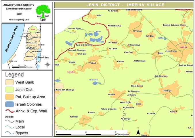
The village of Imreiha (pop.: 500) is located in a mountainous area in Jenin governorate. It is situated 2 kilometers west of the colony of Homish and 4 kilometers east of the colonies of Mabodotan 1 and Mabodotan 2 as well as 20 kilometers south west of the city of Jenin. There are 4 clans in the village all of which are refugees; Turkman, Hamdona, Abu Irmeila and Abu A’abed.


Photo 2: An Israeli military jeep passing in front of Palestinian houses in Imreiha


The roots of the Imreiha clans go back to the village of Al Sindiyana near the city of Haifa which was occupied in 1948. The Haghana terrorist gangs forced the clans out of their village where they finally re-settled in Al Lijja region between the city of Jenin and the village of A’anin. They have stayed there for about 20 years. In the aftermath of the 1967 war, Israeli occupation forces chased them off and uprooted their tents and pushed them to move to the village of Imreiha.  


The head of the village council recalls that not only Israeli occupation forces continuously worked on dislodging the refugee clans of the village, they have also denied it any type of recognition. The relevant Israeli authorities describe the village as an illegal gathering in Area C. As such, the village lacks the bare minimum basic infrastructure as it lacks schools, clinics, agricultural roads, electrical or water networks as well as a mosque. The non-recognition is seen as a part of the occupation forces’ plans to pressure the 75 families in the village to leave the village.


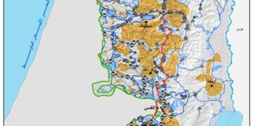
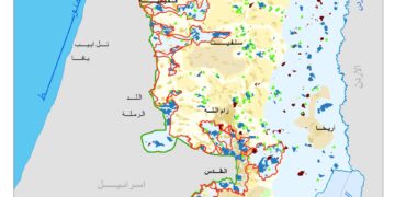
It is worth noting that since the eruption of the current Intifada in 2000 and with the construction of the Israeli Racist Isolation Wall west of the village, a marked increase in the daily harassment by the occupation forces against the residents of the village has been recorded. The close proximity of the village to the Wall, the colonies and the by-pass roads connecting between them has made the village an easy prey for Israeli attacks especially after the establishment of three watch towers and its associated gates on the village’s eastern and western entrances as well as on the western entrance of the village of Ya’abad. These towers form a tool to prohibit the herders from reaching their natural grazing areas which would eventually force them to leave the region.


The establishment of the towers has made the movement of the residents extremely difficult especially during the night hours as the iron gates are usually shut after 8:00 PM and re-opens at 6:00 AM. This movement restriction has forced Palestinians to use donkeys or to walk on foot for long distances to reach their destinations. Case in point is the fact that the organization CARE International was implementing a fodder distribution project in the village. Its car reached the village after the gates were closed down in April 2008. As such, the Israeli soldiers manning the gate prevented the car from entering through the gate and then forced its driver to unload its content on the road which made it extra difficult to transport it back into the village.


Finally, the head of the village council warned against a new colonial plan that aims at erasing the village from existence for the benefit of enlarging the nearby colonies on its expense.


Prepared by:
The Land Research Center
LRC

Recommended For You

INFOGRAPHIC: ISRAELI SETTLER VIOLENCE IN 2025

by arij
April 16, 2026
0

INFOGRAPHIC: ISRAELI SETTLER VIOLENCE IN 2025     Prepared by:   The Applied Research Institute – Jerusalem  

Read moreDetails

أدوات غير مباشرة للاستيطان الإسرائيلي في مناطق (أ) و(ب) لإعادة تشكيل الجغرافيا والسيطرة في الضفة الغربية   

by arij
April 16, 2026
0
العدالة المؤجلة ورأي بلا تنفيذ: من قرار المحكمة إلى واقع الضم

منذ توقيع اتفاقيات أوسلو في تسعينيات القرن الماضي، تم تقسيم الضفة الغربية إلى ثلاث مناطق إدارية وأمنية: (أ)، (ب)، و(ج)، بهدف تنظيم المرحلة الانتقالية نحو تسوية نهائية. وبموجب...

Read moreDetails

INFOGRAPHIC: Palestinian Trees – Victims of the Israeli occupation Army & Settler Groups in 2025

by arij
April 16, 2026
0

    INFOGRAPHIC: Palestinian Trees - Victims of the Israeli occupation Army & Settler Groups in 2025 Prepared by:   The Applied Research Institute – Jerusalem  

Read moreDetails

ذكرى الـ 50 ليوم الأرض: فلسطين بين ذاكرة الدم وصمود البقاء    

by arij
April 16, 2026
0

في الثلاثين من آذار، لا يستحضر يوم الأرض في الوعي الفلسطيني بوصفه مناسبة رمزية عابرة، بل كحدث تأسيسي متجدد يعكس استمرارية الصراع على الأرض والهوية. وبعد مرور خمسين...

Read moreDetails

الاحتلال الإسرائيلي يستهدف مشاريع تنموية في قرية جورة الشمعة جنوب شرق بيت لحم

by arij
March 14, 2026
0
الاحتلال الإسرائيلي يستهدف مشاريع تنموية في قرية جورة الشمعة جنوب شرق بيت لحم

في يوم الاربعاء الموافق الرابع من شهر اذار من العام من العام 2026, سلمت سلطات الاحتلال الاسرائيلي (الإدارة المدنية الاسرائيلية) أهالي قرية جورة الشمعة جنوب شرق مدينة بيت...

Read moreDetails
Next Post
جيش الاحتلال الإسرائيلي يمنع المزارعين في قرية امريحة من استكمال بناء الخزانات المائية

جيش الاحتلال الإسرائيلي يمنع المزارعين في قرية امريحة من استكمال بناء الخزانات المائية

LATEST NEWS

مناطق نفوذ المستوطنات ودورها في إعادة تشكيل الجغرافيا الفلسطينية

مناطق نفوذ المستوطنات ودورها في إعادة تشكيل الجغرافيا الفلسطينية

by arij
April 23, 2026
0

........................................................

التمدد الاستيطاني الإسرائيلي في الضفة الغربية المحتلة وأثره في تقويض مقومات الدولة الفلسطينية

التمدد الاستيطاني الإسرائيلي في الضفة الغربية المحتلة وأثره في تقويض مقومات الدولة الفلسطينية

by arij
April 16, 2026
0

........................................................

INFOGRAPHIC: ISRAELI SETTLER VIOLENCE IN 2025

by arij
April 16, 2026
0

........................................................

العدالة المؤجلة ورأي بلا تنفيذ: من قرار المحكمة إلى واقع الضم

أدوات غير مباشرة للاستيطان الإسرائيلي في مناطق (أ) و(ب) لإعادة تشكيل الجغرافيا والسيطرة في الضفة الغربية   

by arij
April 16, 2026
0

........................................................

flag_yellow_lowEU-PfP-Logo

This website and its content were initiated in 1993 by the Applied Research Institute – Jerusalem (ARIJ) and the Land Research Center (LRC) with the support from the European Union up until 2023. Since then, the Applied Research Institute – Jerusalem (ARIJ) has taken over the continued development and maintenance of the website. The views expressed remain solely those of ARIJ) and do not necessarily reflect those of the European Union.

© 2026 Copyright | ARIJ | All Rights reserved.

No Result
View All Result
  • Home
  • Settlements
    • New Israeli Settlements
    • Settlement Expansion
  • Israeli Violations
    • Agriculture
    • Confiscation
    • Demolition
    • Environment
    • Eviction of Palestinians
    • Settlers Attacks
  • Bypass Roads
  • Israeli Plans
  • Segregation
    • Checkpoints
    • Closure
    • Separation Plans
  • Military Orders
  • Reports
    • Daily Report
    • Monthly Report
    • Quarterly Report

© 2026 Copyright | ARIJ | All Rights reserved.