• About The Project
  • Palestine in Century
  • Selected Maps
  • Glossary
  • About ARIJ
  • About LRC
  • By Year
    • Case Studies By Year
    • Daily Report By Year
Sunday, June 7, 2026
POICA
No Result
View All Result
  • Home
  • Settlements
    • New Israeli Settlements
    • Settlement Expansion
  • Israeli Violations
    • Agriculture
    • Confiscation
    • Demolition
    • Environment
    • Eviction of Palestinians
    • Settlers Attacks
  • Bypass Roads
  • Israeli Plans
  • Segregation
    • Checkpoints
    • Closure
    • Separation Plans
  • Military Orders
  • Reports
    • Daily Report
    • Monthly Report
    • Quarterly Report
No Result
View All Result
POICA
No Result
View All Result

New Israeli Military Orders to put-up Watchtowers to control Bypass road Southeast of Bethlehem Governorate

September 9, 2007
in Military Orders
New Israeli Military Orders to put-up Watchtowers to control Bypass road Southeast of Bethlehem Governorate

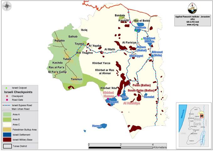
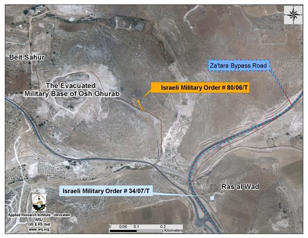
On August 23, 2007, the Israeli Army issued a new military order holding number (34/07/T) to confiscate a 225 square meter of Palestinian land to build a military watchtower just across Za�tara bypass road southeast of Beit Sahour city in Bethlehem Governorate.


The new military order came to complement an Israeli military order holding number (80/06/T), issued by the Israeli Army back in September 2006, but was only declared in August 2007. The September 2006 military order is to confiscate 290 square meters of the Palestinian lands, just one hundred meter away from the location of the other military order.


Both orders were issued under the pretext of military purposes to tighten control over bypass road # 3157 ( Za�tara bypass road) used by Israeli settlers. Construction work to put-up the watchtowers is proceeding apace in the targeted areas. See Map 1

Map of the Confiscated Lands & the Two Military Orders   


Pictures of the Constructions in the Targeted Area


The Issuance of the two military orders coincided with the opening of Za'tara Bypass Road – Road # 3157 (the southern Gate to Jerusalem) on August 31, 2007 by Mayor of Gush Etzion settlement bloc. Shaul Goldstein and the Israeli Minister of Strategic Affairs Avigdor Lieberman. The road is to serve Israeli settlers of Gush Etzion settlement bloc. as it will minimize their traveling time to Jerusalem to 10 minutes.


Za�tara Bypass Road (Road # 3157)

Za�tara bypass road number 3157 stretch across 6.5 km in length in Bethlehem governorate In February 2002, the Israeli Army issued military order number 02/02/C to seize Palestinian land southeast of Bethlehem governorate under the pretext of 'military purposes, to constructanew Israeli bypass road to connect the illegal Israeli settlements cluster located southeast of Bethlehem governorate (Nikodim, Kfar Eldad (El David) and Teqou(including C & D) with Jerusalem via Har Homa settlement to further Israeli strangulate Bethlehem governorate from its eastern side.. The Israeli colonial road, which extends 8 Km in length take on an area of more than 830 dunums including the security buffer zone on (75 meters on each side of the road). The land used for the construction of the road were agricultural lands confiscated inform several Palestinian communities (Beit Sahour, Bethlehem, Za�tara, Ras-El Wad, Teqou, Al-Swahreh and Al-Fourdis). What makes things worse is that the Israeli Army is reluctant to allow Palestinians to use the bypass road, which is built on their lands in the first place. See Photo 4 & Photo 5


Pictures of the construction of the Bypass road (February 2002)


To Conclude          

Under the pretext of securing the Jewish settlements inside the Occupied Palestinian Territory, Israel continue to violate the signed agreements and International laws.  Oslo Agreement (The interim agreement of 1995), article1, item 2 and 4 clearly state (… the unity and integrity of the Palestinian people in the West Bank and Gaza Strip shall be maintained and respected…). The ''Lateral Roads'', or what people call ''bypass roads'' -because they are meant to circumvent (i.e. bypass) Palestinian built up areas, are now disconnecting Palestinian communities from each other.


  • Also Article 147 of the Fourth Geneva Convention indicated that: â��Extensive destruction and appropriation of property not justified by military necessity and carried out unlawfully and wantonly, is a grave breach of the Convention.â��

  • Article (23) of the Hague Convention IV (18 October 1907) provides that: 'To destroy or seize the enemy's property, unless such destruction or seizure be imperatively demanded by the necessities of warâ��.


Prepared by
The Applied Research Institute – Jerusalem
ARIJ

Recommended For You

سلطات الاحتلال الإسرائيلي بصدد الاستيلاء على موقع قبر النبي صموئيل شمال غرب مدينة القدس

by arij
May 23, 2026
0
سلطات الاحتلال الإسرائيلي بصدد الاستيلاء على موقع قبر النبي صموئيل شمال غرب مدينة القدس

 نشرت سلطات الاحتلال الإسرائيلي في الثامن عشر من شهر أيار من العام 2026 اعلانا مفاده الاستيلاء على الأراضي الفلسطينية في قرية النبي صموئيل شمال غرب القدس المحتلة. وجاء...

Read moreDetails

إقامة منطقة عسكرية عسكرية داخل أراضي (أ) في جنين

by arij
May 19, 2026
0
إقامة منطقة عسكرية عسكرية داخل أراضي (أ) في جنين

   في السابع من شهر أيار من العام 2026، وزعت سلطات الاحتلال الإسرائيلي أمرا عسكريا جديدة على أهالي مدينة جنين يقضي بمصادرة 7.2 دونما من الأراضي الفلسطينية في...

Read moreDetails

“بمساحة اجمالية 177 دونما من أرضي البيرة وبيتين”, طريق استيطاني لخدمة البؤر الاستيطانية في محافظة رام الله

by arij
May 18, 2026
0
“بمساحة اجمالية 177 دونما من أرضي البيرة وبيتين”, طريق استيطاني لخدمة البؤر الاستيطانية في محافظة رام الله

في الحادي عشر من شهر أيار من العام 2026, نشرت دائرة أراضي إسرائيل اعلانا جديدا يقضي بمصادرة المزيد من الأراضي الفلسطينية في محافظة رام الله لأغراض استيطانية في...

Read moreDetails

“في خدمة مستوطنة ناحال حيلتس”, طريق استيطاني إسرائيلي جديد على أراضي بتير وبيت جالا في محافظة بيت لحم

by arij
May 18, 2026
0
“في خدمة مستوطنة ناحال حيلتس”, طريق استيطاني إسرائيلي جديد على أراضي بتير وبيت جالا في محافظة بيت لحم

تواصل سلطات الاحتلال الإسرائيلي إحكام سيطرتها على المزيد من الأراضي الفلسطينية في الضفة الغربية المحتلة، وهذه المرة من خلال استهداف أراضي محافظة بيت لحم. ففي السادس والعشرين من...

Read moreDetails

مناطق نفوذ المستوطنات ودورها في إعادة تشكيل الجغرافيا الفلسطينية

by arij
April 23, 2026
0
مناطق نفوذ المستوطنات ودورها في إعادة تشكيل الجغرافيا الفلسطينية

أصدرت سلطات الاحتلال الإسرائيلي في العاشر من شهر نيسان 2026 الكراسة رقم (273)، وهي وثيقة تضم مجموعة من المناشير والأوامر والتعيينات الإسرائيلية المتعلقة بالجوانب الأمنية والعسكرية والإدارية، إضافة...

Read moreDetails
Next Post
The Israeli Army is towards Ethnically Cleanse two Palestinian Communities in Tubas Governorate in the Northern Jordan valley

The Israeli Army is towards Ethnically Cleanse two Palestinian Communities in Tubas Governorate in the Northern Jordan valley

LATEST NEWS

سلطات الاحتلال الإسرائيلي بصدد الاستيلاء على موقع قبر النبي صموئيل شمال غرب مدينة القدس

سلطات الاحتلال الإسرائيلي بصدد الاستيلاء على موقع قبر النبي صموئيل شمال غرب مدينة القدس

by arij
May 23, 2026
0

........................................................

إقامة منطقة عسكرية عسكرية داخل أراضي (أ) في جنين

إقامة منطقة عسكرية عسكرية داخل أراضي (أ) في جنين

by arij
May 19, 2026
0

........................................................

الآثار كأداة للضم الزاحف: مشروع القانون الإسرائيلي لإعادة هندسة الجغرافيا والهوية في الضفة الغربية

الآثار كأداة للضم الزاحف: مشروع القانون الإسرائيلي لإعادة هندسة الجغرافيا والهوية في الضفة الغربية

by arij
May 23, 2026
0

........................................................

النكبة الفلسطينية في ذكراها الثامنة والسبعين: من التطهير العرقي إلى الإبادة وإعادة هندسة الجغرافيا الفلسطينية 

النكبة الفلسطينية في ذكراها الثامنة والسبعين: من التطهير العرقي إلى الإبادة وإعادة هندسة الجغرافيا الفلسطينية 

by arij
May 18, 2026
0

........................................................

flag_yellow_lowEU-PfP-Logo

This website and its content were initiated in 1993 by the Applied Research Institute – Jerusalem (ARIJ) and the Land Research Center (LRC) with the support from the European Union up until 2023. Since then, the Applied Research Institute – Jerusalem (ARIJ) has taken over the continued development and maintenance of the website. The views expressed remain solely those of ARIJ) and do not necessarily reflect those of the European Union.

© 2026 Copyright | ARIJ | All Rights reserved.

No Result
View All Result
  • Home
  • Settlements
    • New Israeli Settlements
    • Settlement Expansion
  • Israeli Violations
    • Agriculture
    • Confiscation
    • Demolition
    • Environment
    • Eviction of Palestinians
    • Settlers Attacks
  • Bypass Roads
  • Israeli Plans
  • Segregation
    • Checkpoints
    • Closure
    • Separation Plans
  • Military Orders
  • Reports
    • Daily Report
    • Monthly Report
    • Quarterly Report

© 2026 Copyright | ARIJ | All Rights reserved.