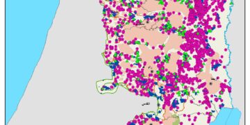
Since the outbreak of the second Intifada, in September 2000, Israel increased the level of restrictions on the movement of Palestinians occupied territory that are unprecedented in scope and time. These restrictions have the Palestinian divided into two separate bodies: the Gaza Strip, which was divided at that time prior to the 2005 disengagement (redeployment) in 4 areas (north of Gaza, Dier Al-Balah, Khan Yunis and Rafah. The other body is the West Bank, divided into six geographical units: North, Center, South, the Jordan Valley, northern Dead Sea, and East Jerusalem. Palestinian travel in the West Bank is now doing through a different set of road system used by the Israeli settlers. The settlers may move around on the Palestinian road system but not the other way around. Palestinians who wishes to travel to Jerusalem must obtain a special permit. However, even the Palestinian roads system involves insecurity, friction with the Israeli Army soldiers, much waiting, and great expense.
Israeli officials claim that the restrictions on movement in the West Bank are necessary procedures, limited in time, to face security threats against Israeli citizens. However, what is happening on the ground gives an indication that Israel is carrying out all of its activities in permanent manner, and employ them to achieve other objectives, among them controlling and regulating the movement of Palestinians across the West Bank and away from the Israeli settlers roads, in other words or according to what is happening on the ground to create two different road systems, one for the Israeli settlers and another for Palestinians, a classic case of apartheid.
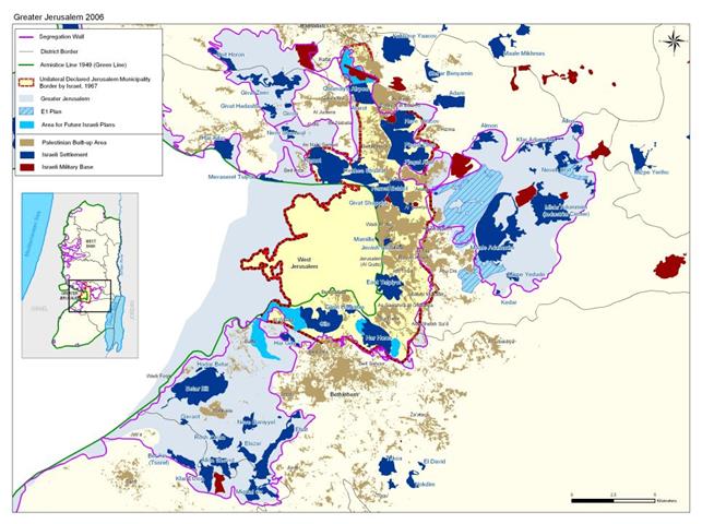
What is E1?
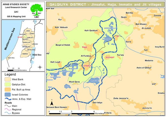
It is a term derived from “East 1” used by the Israeli Ministry of Housing to what is currently part of extended municipal plans of Ma’aleh Adumim settlement. E1 touches the edge of the municipal boundary of Jerusalem, as well as the neighborhoods/towns of Anata, Abu Dis, Azariya and A-Zayim that lie on the eastern border of the city. See Map 1 and Cross section of Greater Jerusalem Map


This road consolidates the Israeli plan to isolate East Jerusalem from the rest of West Bank where the natural environs of the Jerusalemite are located. On the other hand, the E1 road will facilitate the movement of Israeli settlers living in the north near Ramallah area to Jerusalem. The road also comes consistent with the E1 neighborhood plan west of Ma’ale Adumim.
|
E1 plan: Israeli plan that ratified by Israeli labor party late leader Yitzhak Rabin. the intention was to establish a new settlement city between Ma’aleh Adummim and Jerusalem. It will include 3,500 housing units and commercial zone, Commercial areas, Hotels and “special housing,” Universities and “special projects,” and others. Its worth to mention that The E1 development program contains no reference at all to the Palestinian population in the area whose lands were confiscated to develop the E1 neighborhood. |
The construction of the E1 road and the E1 neighborhood will deprive Palestinian villages from lands available for future development and separate the northern area of the West Bank from the south area.
Viable Palestinian State through territorial Contiguity not by Contiguate Transportation system
Israel, is trying to sell its propaganda of establishing contiguity between the Palestinian West Bank territory to the world, by saying that Palestinian have access to all West Bank areas, by which making the future Palestinian state viable and contiguous. However, the facts on the ground are something else and the word contiguous as used by Israel refers to a transportation road system, which does not constitute the ingredient for a contiguous viable state. Only territorial contiguity really constitutes a base for a viable state, a concept accepted and endorsed by many: 'The United States supports the establishment of a Palestinian state that is viable, contiguous, sovereign, and independent, so that the Palestinian people can build their own future in accordance with my vision set forth in June 2002 and with the path set forth in the roadmap.'
Letter from US President Bush to Israeli P M Sharon April 14, 2004
|
'The United States supports the establishment of a Palestinian state that is viable, contiguous, sovereign, and independent, so that the Palestinian people can build their own future in accordance with my vision set forth in June 2002 and with the path set forth in the roadmap.' Letter from US President Bush to Israeli P M Sharon April 14, 2004
'Without a viable and contiguous Palestinian state that represents the aspirations of the Palestinian people – meaning enough land to function well – there will be no peace for either Palestinian people or Israelis' Answering senators’ questions, US secretary of state Condoleezza Rice January 18, 2005
Creation of an independent Palestinian state with provisional borders through a process of Israeli-Palestinian engagement, launched by the international conference. As part of this process, implementation of prior agreements, to enhance maximum territorial contiguity, includes further action on settlements in conjunction with establishment of a Palestinian state with provisional borders. A Performance-Based Roadmap to a Permanent Two-State Solution to the Israeli-Palestinian Conflict Washington, DC April 30, 2003 |
Israel has offered the Palestinians in the past and still does a contiguous territory within the occupied West Bank by means of transportation system that constitute of tunnels and bridges to connect the Palestinian enclaves in the West Bank, even though the Israelis are will aware that transportation contiguity does not constitute a territorial contiguity which is the main base to any viable state.
The need for physical contiguity between the West Bank territory is significant, and without which, the future Palestinian state will not be feasible and bridges and tunnels simply will not do it.
At this point of the Palestinian – Israeli conflict, one fact remains constant and that is only a Palestinian state with a contiguous territorial area with East Jerusalem as its capital is the only solution to put an end to the conflict. What Israel is doing forcing facts on the ground and manipulate the geographic and demographic balance of the occupied territory, particularly in occupied East Jerusalem; will only serve to destroy the chances of fruitful negotiation between the two sides to reach a peace agreement based on a two-state for two nations solution, with Jerusalem as the capital to both.
Prepared by
The Applied Research Institute – Jerusalem
ARIJ