The Israeli occupation army continues with its policy of amending the previously issued military orders concerning the land that was taken for the construction of the path of the Annexation and Expansion Wall in the West Bank. The new amendments mean the confiscation of new land areas along the path of the Wall (colored in red in the newly issued military decrees' attached maps ) and the re-iteration of the confiscation of previously taken land (the areas colored in black in the attached maps).
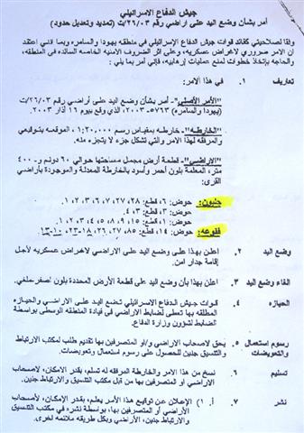
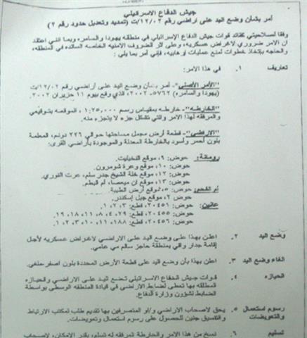
In this context, the military orders number T/12/02 was amended so as to put hand over 226 dunums of land from the villages of Rummane, 'Anin in the West Bank and Un Al Fahim inside the green line ( the areas colored in red and black in the attached map). The target land is already destroyed under the path of the Wall which was built there in the year 2003.
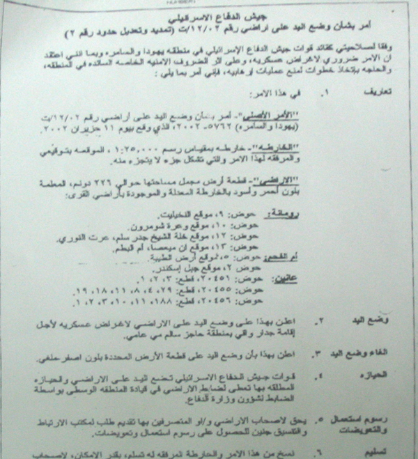
(Photo 1 & 2 : military order No. T/12/02 and the attached map )
According to the new amendments, the width of the Wall path was reduced by narrowing the patrol road that runs along the western side of the Wall path and by decreasing the distance between the main body of the Wall and its parallel fences on both sides. Consequently, the order allegedly abandoned the confiscation of the area that is colored in yellow in the attached map, but given that the Israeli occupation authorities maintain a no-man zone of 150 meters on each side of the Wall the Palestinians land owners, in practice, cannot take benefit of their returned land as it remains inaccessible.
The target land is located in basins numbers:
· 9, 10,12 & 13- Rummane village;
· 5 & 2 – Um Al Fahim town ( inside the green line);
· 455 & 456 – 'Anin village.
Similar amendment measures were recently taken in the following areas:
· The village of Bardala, Tubas governorate;
· The villages of Jalbon & Faqu'a, Jenin governorate;
· The villages of Jarushiya, Ar Ras and Faro'un, Tulkarem governorate;
· They villages of Jayyus and Azzun, Qalqiliya governorate.
Background to Rummane village
It is located 13 km to the north west of Jenin city. Its total surface land area is 8688 dunums, of which 691 dunums as built up area. The village population mounts to 3000 according to the Palestinian Central Bureau of Statistics (PCBS). The village depends mainly on agriculture and animal husbandry as main income.
The village has no basic infrastructure such as water and electricity services as a result of the intentional continued marginalization and negligence on the part of the Israeli military occupation since 1967.
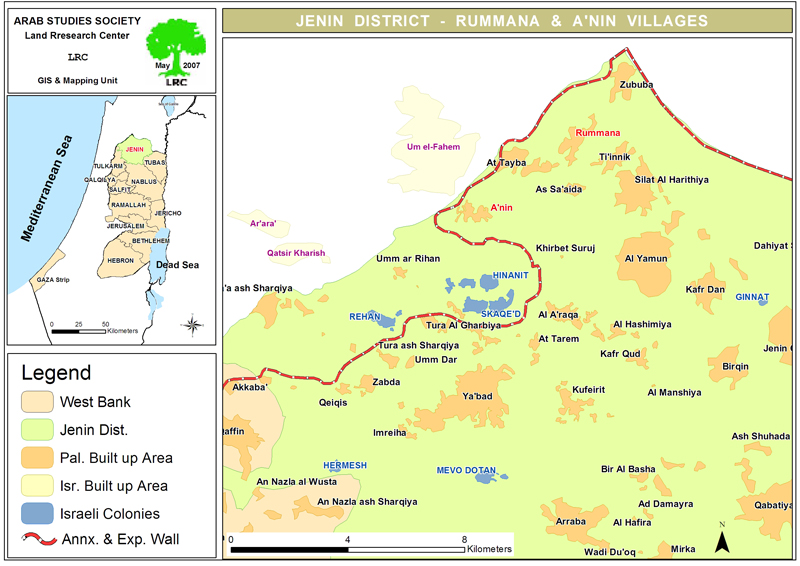
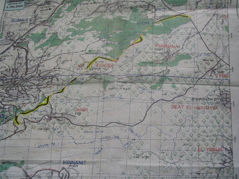
(Map 1: location of Rummana and A'nin)
The village and the Wall
About 100 dunums of the village lands were destroyed under the path of the Wall when it was built in 2003 in the northern, southern and western sides of the village. Another 84 dunums were separated behind it. By building the Wall, the village was totally separated from the Arab villages and town in the western side of the green line such as um Al Fahim. Neither agricultural Wall gates nor crossing terminals were built along the path of the Wall to the west of the village.
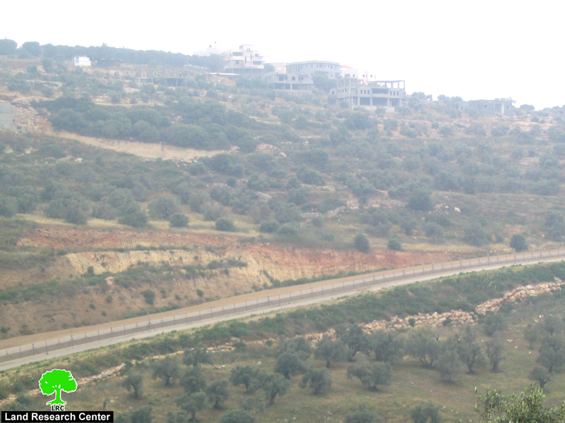
(Photo 3: the Wall path separating between Rummana and Um Al Fahim town)
Previous land grabbing
At the beginning of the current Intifada the Israeli occupation authorities confiscated 40 dunums of Rummana and Zabbuba lands to build the Salim military checkpoint and military base in the north western corner of Jenin district close to Megiddo road intersection. The place hosts now the offices of the so-called Israeli civil administration in Jenin district and the military liaison offices as well as a temporary detention centre.
Wall impacts on Rummana
According to the figures given by the Rummana local council, at least 32 Palestinian families out of 450 have migrated the village to nearby towns and cities to find living as a result of the continuous harassment and closure on the part of the Israeli army.
In addition, about 140 families depend on the UN's World Food Program as a main source of livelihood in the village. Another 70 families depend on different international aid agencies for their living due to the Israeli closure and collective economic punishment.
Background to A'nin village
The village is located 17 km to the north west of Jenin city. Its total land area is 12272 dunum, including 420 as built up area. The village's population is about 3500 (PCBS).
Wall impacts on A'nin village
The Wall was built at the length of 7 km besieging the village from the west and south. About 6000 dunums ( almost 50% of the village lands were either destroyed or separated behind the Wall route reducing the lives of almost 3500 people to nothing after extracting their sources of livelihood. A'nin, to a great extent, was reliant on the nearby town of Um Al Fahim in the other side of the green line. However. After the construction of the Wall, the village lost all of its links to Um Al Fahim and became one of the most Wall stricken areas in Jenin district. Now a days, 136 families out of 500 are reliant on the UN's World Food Program, another 40 families on UNRWA and another 36 families on different international aid agencies.
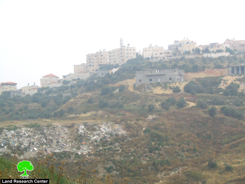
(Photo 4: The town of Um Al Fahim facing the village of A'nin )
As regards A'nin lands separated behind the Wall, 3000 dunums of which are planted with fruitful olive trees and 50 dunums with almond. The remaining areas have become a grazing zone for the cow herds released by the settlers of Shaked colony which was included in the Wall. The village council had levied many complaints with the occupation authorities against this aggression but to no avail yet.
The Israeli army erected only one agricultural Wall gate carrying the number of 214 for the use of farmers and land owners to cross into their separated lands. However, it remains closed all the time except during the olive harvesting season when a limited number of farmers are allowed access based on the acquisition of valid passing permits from the Israeli military.
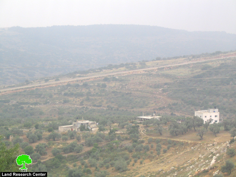
(Photo 5: Wall route at the western edge of A'nin)
Prepared by
The Land Research Center
LRC