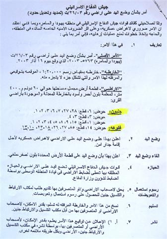
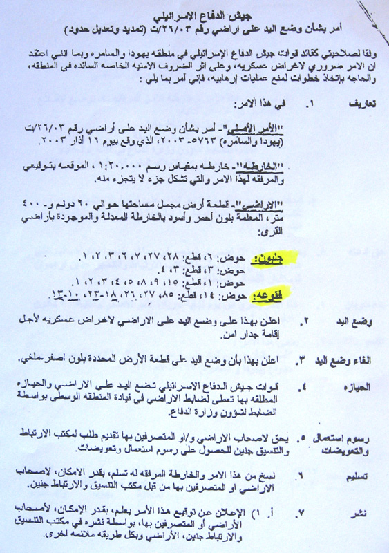
The Israeli occupation army issued new amendments on the military order number T/26/03 under the term extension and amendments of borders concerning the lands of Jalbun and Faqua'a villages, Jenin governorate.
This step comes as a continuation of the new Israeli policy of amending the previously issued military orders concerning the land that was taken for the construction of the path of the Segregation Wall in the West Bank. In the aforementioned order the new amendment means the re-iteration of the confiscation of the land previously taken for the construction of the path of the Wall (the area colored in black in the attached map).
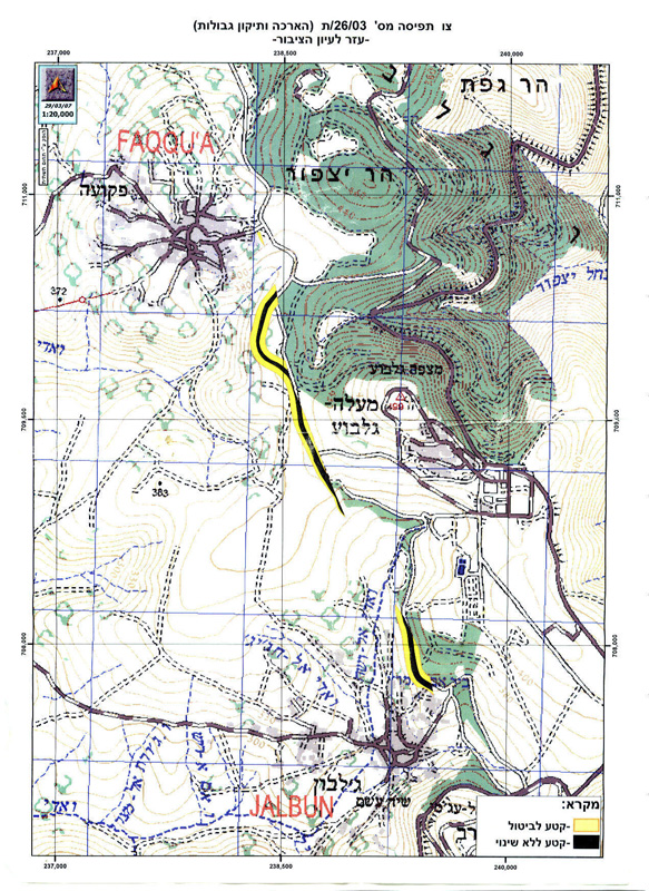
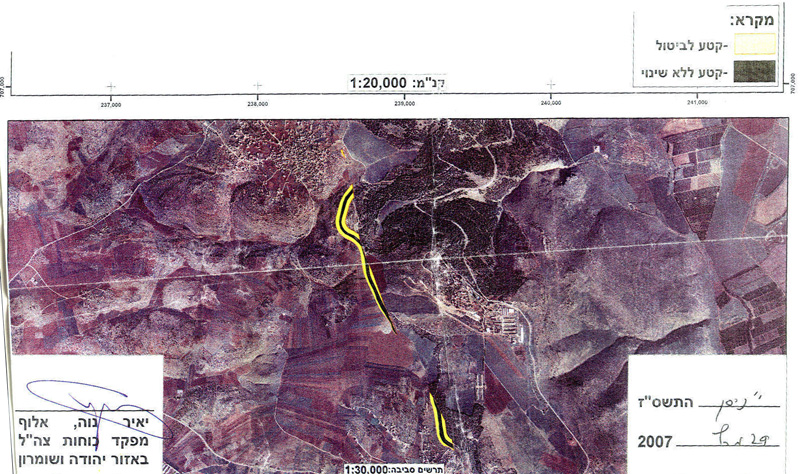
In this context, the military order put hand over an area of 60 dunums and 400 m2 from the two villages of Jalbun and Faqqu'a (the areas colored in red and black in the attached map). The target land is already destroyed under the path of the Wall which was built there in the year 2003.
 j
j
(Photos 1, 2 & 3 : military order No. T/12/02 and the attached map and photo )
According to the new amendment, the width of the Wall path was reduced by narrowing the patrol road that runs along the western side of the Wall path and by decreasing the distance between the main body of the Wall and its parallel fences on both sides. Consequently, the order allegedly abandoned the confiscation of the area that is colored in yellow in the attached map, but given that the Israeli occupation authorities maintain a no-man zone of 150 meters on each side of the Wall the Palestinians land owners, in practice, cannot take benefit of their returned land as it remains inaccessible.
The target land is located in basins numbers:
- 6, 3 and 1 from the land of Jalbun village;
- 14 from the land of Faqqu'a village.
In the last two month, the Israeli occupation army took similar amendment steps in the following areas:
- The village of Bardala, Tubas governorate;
- The villages of Rummane and Zabuba, Jenin governorate;
- The villages of Jarushiya, Ar Ras and Faro'un, Tulkarem governorate;
- They villages of Jayyus and Azzun, Qalqiliya governorate.
Affected land owners and faremrs
According to the Jalbun and Faqua'a village councils, the following is a list of the affected land owners and number of parcel:
|
No. |
Name |
Village |
No. of basin |
No. of parcel |
|
1 |
Awad ali |
Jalbun |
6 |
1 |
|
2 |
Tawfiq Abdul Khaliq |
Jalbun |
6 |
2 |
|
3 |
'Arif Awwad |
Jalbun |
6 |
3 |
|
4 |
Ahamd Qasem |
Jalbun |
6 |
6 |
|
5 |
Omer Abdul Rahman |
Jalbun |
6 |
7 |
|
6 |
|
Jalbun |
6 |
27 |
|
7 |
Sharif Abdul Khaliq |
Jalbun |
6 |
28 |
|
8 |
|
Jalbun |
3 |
3 |
|
9 |
|
Jalbun |
3 |
4 |
|
10 |
Sharif Naji |
Jalbun |
1 |
1 |
|
11 |
'Arif Awwad |
Jalbun |
2 |
1 |
|
12 |
|
Jalbun |
3 |
1 |
|
13 |
Mahmud Najib |
Jalbun |
4 |
1 |
|
14 |
Wasila Mustafa |
Jalbun |
5 |
1 |
|
15 |
Fayez Mustafa and brothers |
Jalbun |
8 |
1 |
|
16 |
Shukri 'Arif |
Jalbun |
9 |
1 |
|
17 |
Manwa As'ad Abu Salama |
Faqqu'a |
14 |
10 |
|
18 |
Na'ila As'ad Abu Salama |
Faqqu'a |
14 |
11 |
|
19 |
Mahmud Ali Abu Salama |
Faqqu'a |
14 |
12 |
|
20 |
Ahmad Hussein Abu Salama |
Faqqu'a |
14 |
13 |
|
21 |
Rafiq Mahmud Abu Salama |
Faqqu'a |
14 |
18 |
|
22 |
Mohammed Saleh Abu Salama |
Faqqu'a |
14 |
19 |
|
23 |
Musa Saleh Abu Salama |
Faqqu'a |
14 |
20 |
|
24 |
Hasan Ibrahim Abu Salama |
Faqqu'a |
14 |
21 |
|
25 |
Hussein Ibrahim Abu Salama |
Faqqu'a |
14 |
22 |
|
26 |
Mahmud Ahamd Barakat |
Faqqu'a |
14 |
23 |
|
27 |
Amneh Mohammed Abu Isa |
Faqqu'a |
14 |
26 |
|
28 |
Ibrahim Khalil Abu Salama |
Faqqu'a |
14 |
27 |
|
29 |
Su'ad Mahmud Abu Salama |
Faqqu'a |
14 |
85 |
Location, population and area
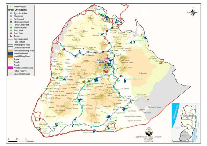
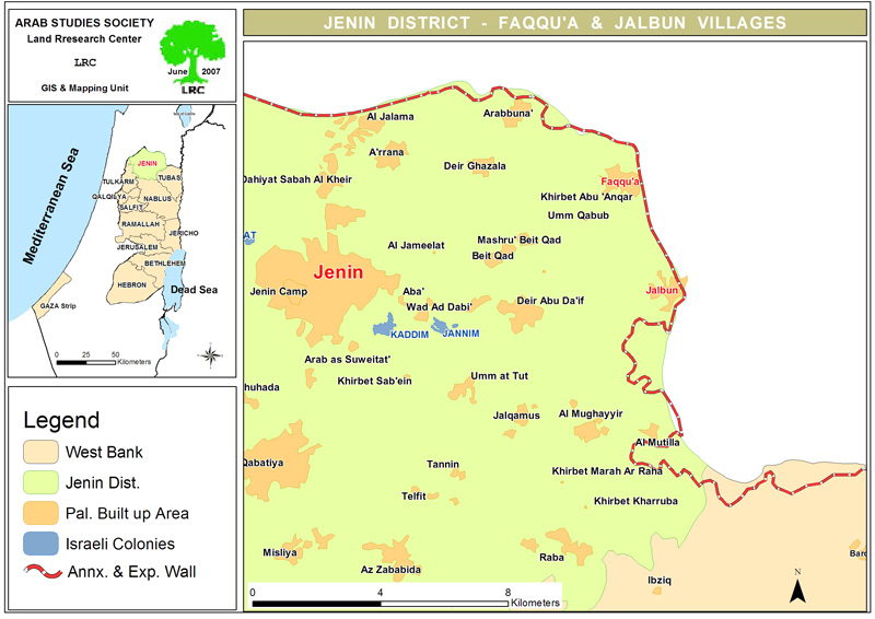
The village of Jalbun is located about 10 km to the north east of Jenin city . Its total land area is 9307 dunums of which 1288 dunums are built up area (source: GIS unit at LRC). Jalbun's population is now 2808 (source: PCBS).
The village of Faqqu'a is the northern neighbor of Jalbun located at the distance of 11 km to the north east of the city of Jenin. Its total surface land area is 9408, including 920 dunums as built up area (source: GIS unit at LRC). The village population is estimated to be now 3931 (source: PCBS). See Map 1
At least 60 % of the population in the two stricken villages depend on agriculture as main income. In the meanwhile, the Faqqu'a village is classified by the World Food Program as one of the three poorest villages in the West Bank.
Impacts of the Wall on the two sisterly villages
When the Segregation Wall was built in the year 2003, more than 100 dunums of Jalbun agricultural lands were completely destroyed under its route and more than 2100 dunums (about 22.5% of the total area of the village) were separated behind it.
On the other hand, the Israeli occupation authorities carried out a demolition campaign in the village since the commencement of the Wall works in the year 2003 during which dozens of homes and businesses were destroyed or threatened to be destroyed.
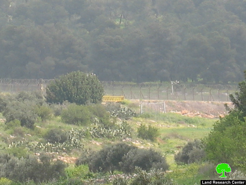
(Photo 4 : the path of the Wall on he land of Faqqu'a, Jenin )
As regards the Faqqua' village, more than 450 dunums of its agricultural land were separated behind the Wall. 40 % of this separated land is cultivated with olive trees (Source: Faqqu'a village council).
Previous land confiscations
Originally, Faqqu'a village had the total land area of 33408 dunums in the year of 1948. Out of this it lost 24000 dunums (about 71% ) during and after the war of 1948 ( Source: ibid).
At the beginning of this year, another 150 dunums of Faqqu'a northern agricultural land located inside the Wall were taken by yet another military order for the purpose of building a ' security' military road that will lead to the newly erected military watch tower at the top of Abu Qasis mountain ( Source: ibid) although land is registered in the taboo in the names of its original Palestinian owners.
Prepared by
The Land Research Center
LRC