• About The Project
  • Palestine in Century
  • Selected Maps
  • Glossary
  • About ARIJ
  • About LRC
  • By Year
    • Case Studies By Year
    • Daily Report By Year
Monday, May 4, 2026
POICA
No Result
View All Result
  • Home
  • Settlements
    • New Israeli Settlements
    • Settlement Expansion
  • Israeli Violations
    • Agriculture
    • Confiscation
    • Demolition
    • Environment
    • Eviction of Palestinians
    • Settlers Attacks
  • Bypass Roads
  • Israeli Plans
  • Segregation
    • Checkpoints
    • Closure
    • Separation Plans
  • Military Orders
  • Reports
    • Daily Report
    • Monthly Report
    • Quarterly Report
No Result
View All Result
POICA
No Result
View All Result

Wall amendments: more land grabbing

May 8, 2007
in Military Orders
Wall amendments: more land grabbing

The Israeli occupation army issued new amendments for three military orders concerning the Wall path in the lands of a number of villages number in Tulkarem  governorate. The three amendments were carried out as followed:


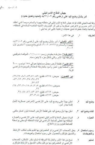
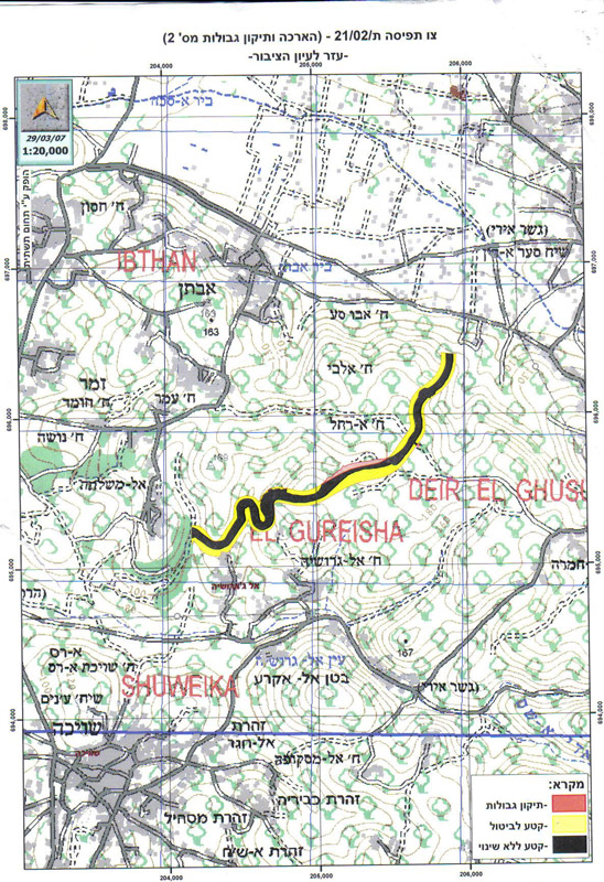
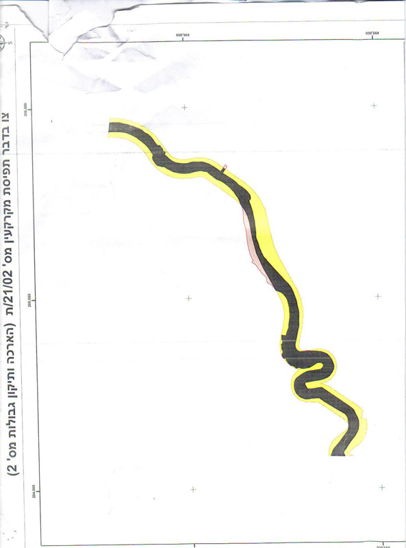
1- Order number T/21/02 which was signed on 6 October, 2002. This amendment put hand over 158 dunums and 900 square meters ( the area colored in red and black in the attached map) which was destroyed under the current path of the Annexation and Expansion Wall. In the meantime, it reduced the width of the Wall path by narrowing the patrol road that runs along the western side of the Wall path and by decreasing the distance between the main body of the Wall and its parallel fences on both sides. Consequently, the order abandoned the confiscation of the area that is colored in yellow in the attached map. The target land belongs to the village of Deir Al Ghusun, Tulkarem governorate, basins 8664, 8668,8662 and 8663.


  c

(Photos 1, 2 & 3: a copy of the military order number T/21/02 and the attached maps)


2- Order number T/22/02 signed on 20 May, 2003. It put hand over an area of 74 dunums and 300 square meters ( the area colored in red and black in the attached map) located under the path of the Wall and belongs to the village of Shuweika at the southern edge of Tulkarem city. As in the previous order the width of the Wall path was reduced by narrowing the patrol road that runs along the western side of the Wall path and by decreasing the distance between the main body of the Wall and its parallel fences on both sides. Consequently, the order abandoned the confiscation of the area that is colored in yellow in the attached map. The target land is located in basins 8435, 8438, 8430 and 8425.


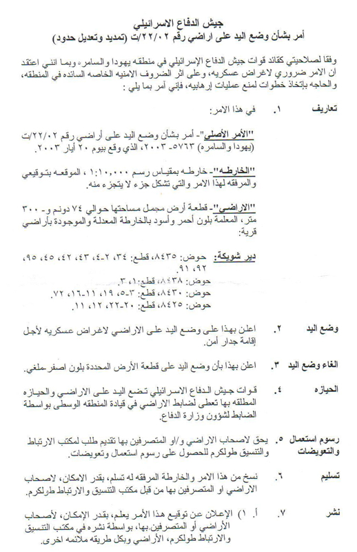
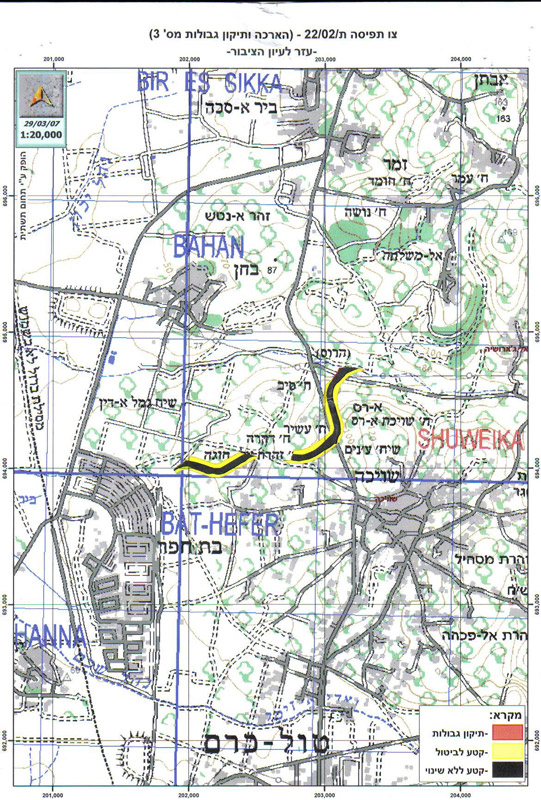
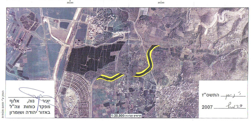
(Photos 4,5, 6 & 7: a copy of the military order number T/22/02 and the attached maps)


3- Order number T/24/02 signed on 20 August, 2002. It put hand over an area of 193 dunums and 800 square meters ( the area colored in red and black in the attached map) located under the path of the Wall and belongs to the villages of Ar Ras and Faro'un in Tulkarem city. As in the previous order the width of the Wall path was reduced by narrowing the patrol road that runs along the western side of the Wall path and by decreasing the distance between the main body of the Wall and its parallel fences on both sides. Consequently, the order abandoned the confiscation of the area that is colored in yellow in the attached map. The target land is located in basins 2,  8472 and 8473.


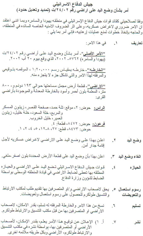
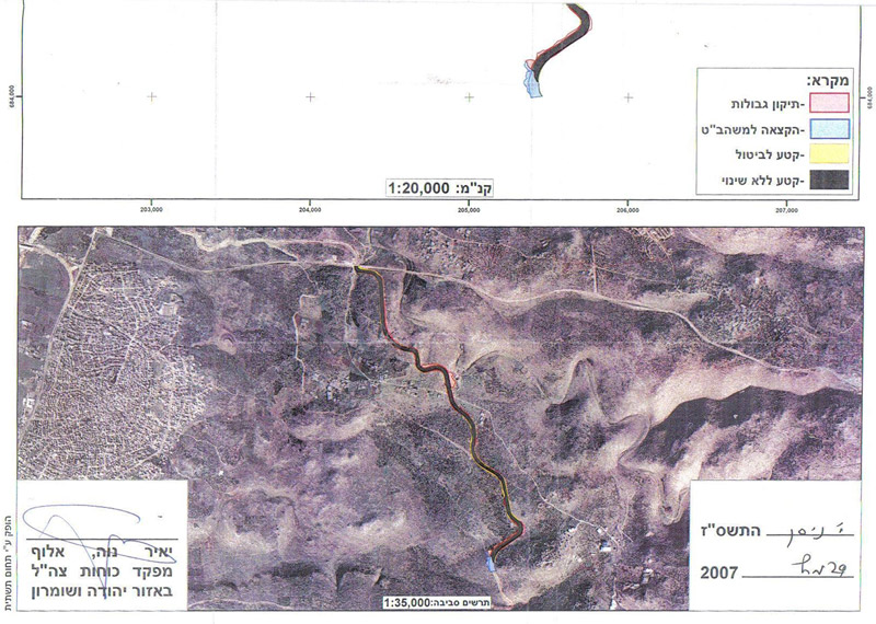
(Photos 8,9 &10: a copy of the military order number T/24/02 and the attached maps)


Meaningless step

In an interview with LRC field worker Mr. Eid Yassin, the head of Ar Ras municipality described the Israeli Wall revision in Tulkarem region as meaningless given that the Israeli occupation authorities maintain a no-man zone of 150 meters on each side of the Wall which means that, in practice, the Palestinians land owners cannot take benefit of their returned land. On the other hand, Mr. Abdul khaliq Jubara who works at Tulkarem municipality said that the Israeli Wall revision decision was made to maneuver the Israeli supreme court's decision of 2006 which ruled that Khirbet Jubara and another two homes in Ar Ras village should be taken out of the Wall.


Wall impacts

As a result of the construction of the Wall more than 400 dunums of agricultural land were destroyed under its route and about 2500 dunums were separated behind it in the village of Deir Al Ghusun. Moreover, the only water well in the village was, also, confiscated and separated behind the Wall.


In Faro'un village, the Wall has destroyed 1000 dunums under its route and almost half of its land -4000 dunums- were separated behind it.


As regards Khirbet Jubara the whole village was separated behind the Wall putting about 300 people in a big jail and making their life miserable.


In Ar Ras village,  about 250 dunums of fertile agricultural land were devastated under the route of the Wall and hundreds others were separated behind it.


Prepared by
The Land Research Center
LRC


Recommended For You

مناطق نفوذ المستوطنات ودورها في إعادة تشكيل الجغرافيا الفلسطينية

by arij
April 23, 2026
0
مناطق نفوذ المستوطنات ودورها في إعادة تشكيل الجغرافيا الفلسطينية

أصدرت سلطات الاحتلال الإسرائيلي في العاشر من شهر نيسان 2026 الكراسة رقم (273)، وهي وثيقة تضم مجموعة من المناشير والأوامر والتعيينات الإسرائيلية المتعلقة بالجوانب الأمنية والعسكرية والإدارية، إضافة...

Read moreDetails

INFOGRAPHIC: Mapping Control – Israeli Militray Orders across the occupied West Bank – 2025

by arij
April 16, 2026
0

    Prepared by:   The Applied Research Institute – Jerusalem

Read moreDetails

سلطات الاحتلال الإسرائيلي تستهدف قرية الجيب بأمر عسكري جديد

by arij
March 17, 2026
0
سلطات الاحتلال الإسرائيلي تستهدف قرية الجيب بأمر عسكري جديد

نشر المسؤول عن الأملاك الحكومية وأملاك الغائبين في الإدارة المدنية الإسرائيلية في الحادي عشر من شهر اذار من العام 2026 اعلاننا مفاده نية ما يسمى " المسؤول عن...

Read moreDetails

سلطات الاحتلال الإسرائيلي تستخدم الأوامر العسكرية لتعمق المشروع الاستيطاني في الضفة الغربية المحتلة

by arij
February 26, 2026
0
سلطات الاحتلال الإسرائيلي تستخدم الأوامر العسكرية لتعمق المشروع الاستيطاني في الضفة الغربية المحتلة

تقديم منذ احتلال الضفة الغربية عام 1967، اعتمدت سلطات الاحتلال الإسرائيلي منهجية واسعة عبر استخدام الأوامر العسكرية كأداة "قانونية" لفرض الوقائع الجغرافية والديموغرافية على الأرض الفلسطينية. وأصبحت هذه...

Read moreDetails

بين مطرقة الأوامر العسكرية وسندان التقييد الجغرافي, أوامر عسكرية إسرائيلية جديدة تطال أكثر من 1000 دونم في طوباس

by arij
November 26, 2025
0
بين مطرقة الأوامر العسكرية وسندان التقييد الجغرافي, أوامر عسكرية إسرائيلية جديدة تطال أكثر من 1000 دونم في طوباس

في الحادي والعشرين من شهر تشرين الأول لعام 2025، تسلّم أهالي محافظة طوباس سلسلة من الأوامر العسكرية الإسرائيلية التي استهدفت مساحات واسعة من الأراضي الفلسطينية في المحافظة. وقد...

Read moreDetails
Next Post
More of Jayyus and Azzun lands taken for Wall revision

More of Jayyus and Azzun lands taken for Wall revision

LATEST NEWS

مناطق نفوذ المستوطنات ودورها في إعادة تشكيل الجغرافيا الفلسطينية

مناطق نفوذ المستوطنات ودورها في إعادة تشكيل الجغرافيا الفلسطينية

by arij
April 23, 2026
0

........................................................

التمدد الاستيطاني الإسرائيلي في الضفة الغربية المحتلة وأثره في تقويض مقومات الدولة الفلسطينية

التمدد الاستيطاني الإسرائيلي في الضفة الغربية المحتلة وأثره في تقويض مقومات الدولة الفلسطينية

by arij
April 16, 2026
0

........................................................

INFOGRAPHIC: ISRAELI SETTLER VIOLENCE IN 2025

by arij
April 16, 2026
0

........................................................

العدالة المؤجلة ورأي بلا تنفيذ: من قرار المحكمة إلى واقع الضم

أدوات غير مباشرة للاستيطان الإسرائيلي في مناطق (أ) و(ب) لإعادة تشكيل الجغرافيا والسيطرة في الضفة الغربية   

by arij
April 16, 2026
0

........................................................

flag_yellow_lowEU-PfP-Logo

This website and its content were initiated in 1993 by the Applied Research Institute – Jerusalem (ARIJ) and the Land Research Center (LRC) with the support from the European Union up until 2023. Since then, the Applied Research Institute – Jerusalem (ARIJ) has taken over the continued development and maintenance of the website. The views expressed remain solely those of ARIJ) and do not necessarily reflect those of the European Union.

© 2026 Copyright | ARIJ | All Rights reserved.

No Result
View All Result
  • Home
  • Settlements
    • New Israeli Settlements
    • Settlement Expansion
  • Israeli Violations
    • Agriculture
    • Confiscation
    • Demolition
    • Environment
    • Eviction of Palestinians
    • Settlers Attacks
  • Bypass Roads
  • Israeli Plans
  • Segregation
    • Checkpoints
    • Closure
    • Separation Plans
  • Military Orders
  • Reports
    • Daily Report
    • Monthly Report
    • Quarterly Report

© 2026 Copyright | ARIJ | All Rights reserved.