• About The Project
  • Palestine in Century
  • Selected Maps
  • Glossary
  • About ARIJ
  • About LRC
  • By Year
    • Case Studies By Year
    • Daily Report By Year
Saturday, May 23, 2026
POICA
No Result
View All Result
  • Home
  • Settlements
    • New Israeli Settlements
    • Settlement Expansion
  • Israeli Violations
    • Agriculture
    • Confiscation
    • Demolition
    • Environment
    • Eviction of Palestinians
    • Settlers Attacks
  • Bypass Roads
  • Israeli Plans
  • Segregation
    • Checkpoints
    • Closure
    • Separation Plans
  • Military Orders
  • Reports
    • Daily Report
    • Monthly Report
    • Quarterly Report
No Result
View All Result
POICA
No Result
View All Result

Series of Israeli Military orders to amend on the Route of the Israeli Segregation Wall in Tulkarem& Jenin Governorates

May 10, 2007
in Military Orders
Series of Israeli Military orders to amend on the Route of the Israeli Segregation Wall in Tulkarem& Jenin Governorates

Dozens of Palestinian landowners in the two Palestinian Governorates of Tulkarem and Jenin received an 'extensions' to previously issued Israeli military orders notifying them that the period of the original military orders of their lands had expired and therefore a new amendment military orders had been issued. The original Israeli military orders were issued in the years 2002 and 2003. See Table (1)


Table 1: Amendments to previously issued Military Order 

Original Military Order

Expiration Date

Extended Military Order

Expiration Date

Locality

District

20/02/T

31/12/2005

20/02/T

31/12/2008

Deir Ghsun, Zeita , 'Ateel

Tulkarem

21/02/T

31/12/2005

21/02/T

31/12/2008

Deir Ghsun

Tulkarem

23/02/T

31/12/2005

23/02/T

31/12/2008

Far'oun

Tulkarem

24/02/T

31/12/2005

24/02/T

31/12/2008

Al Ras, Far'oun

Tulkarem

57/03/T

31/12/2005

57/03/T

31/12/2008

Nazlet Issa

Tulkarem

12/02/T

31/12/2005

12/02/T

31/12/2010

Rumana ,Fahme, 'Aneen

Jenin

26/03/T

31/12/2005

26/03/T

31/12/2010

Jalboun,Faqu'a

Jenin

28/03/T

31/12/2005

28/03/T

31/12/2010

Faqu'a , 'Arabouna , Al Mazar

Jenin


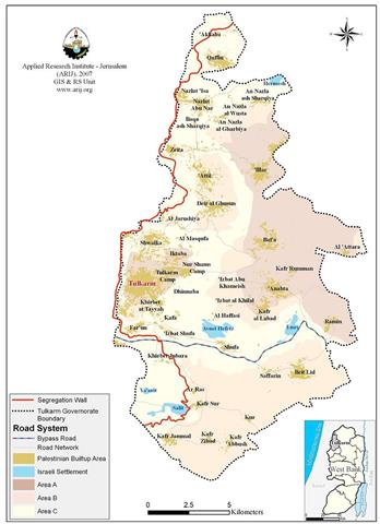
The military orders in question were issued during the years 2002 and 2003, to confiscate thousands of dunums of private Palestinian lands across the occupied Palestinian Territory including Tulkarem and Jenin Governments to build the Israeli Segregation Wall. See Maps 1 & 2 Below

Map of Tulkarem Governorate


Map of Jenin Governorate


Apparently, Israel attempt to legalize its work regarding the Segregation Wall in the Occupied Palestinian territory by pertaining it as preventive measures according to their claim, at least until the time of the new extension date come to an end, at which time the construction work on the entire Segregation Wall will be complete and that when Israel will define its political borders for the first time since its establishment in 1948. Several Israeli officials, including the Israeli secretary of state Livini has repeatedly said about the Segregation Wall and its function that it will exceed its claimed security purpose to serve as a permanent border for the state of Israel.


Table (2): Total Wall length and isolated lands in Tulkarem & Jenin Governorates

Governorate

Total Segregation Wall Length- (Km)

 Isolated Lands Behind the Wall – (Dunum)

Tulkarem


40

19,959

 Jenin


70

32,400


The Israeli Apartheid Segregation Wall violates numerous human rights laws, of which: the right to property, the right to work, the right to an adequate standard of living and the right of freedom of movement,


It becomes clear that the Israeli decision to build the Apartheid Segregation Wall in the Palestinian Territory was a step toward the expansion of the Israeli borders and settlements, not as they claim to achieve peace and security to the Israeli people.


The appropriation and destruction of Palestinian land is an especially serious violation of the Fourth Geneva Convention, Article 147 of which clearly prohibits,''extensive destruction and appropriation of property, not justified by military necessity and carried out unlawfully and wantonly.''  Violations of Articles of the Fourth Geneva Convention constitute grave breaches of the Convention and should be prosecuted as War Crimes.


Also The Hague Regulations expressly forbids an occupying power 'to destroy or seize the enemy's property, unless such destruction or seizure is imperatively demanded by the necessities of war' (Article 23). 


Prepared by
The Applied Research Institute – Jerusalem
ARIJ


Recommended For You

إقامة منطقة عسكرية عسكرية داخل أراضي (أ) في جنين

by arij
May 19, 2026
0
إقامة منطقة عسكرية عسكرية داخل أراضي (أ) في جنين

   في السابع من شهر أيار من العام 2026، وزعت سلطات الاحتلال الإسرائيلي أمرا عسكريا جديدة على أهالي مدينة جنين يقضي بمصادرة 7.2 دونما من الأراضي الفلسطينية في...

Read moreDetails

“بمساحة اجمالية 177 دونما من أرضي البيرة وبيتين”, طريق استيطاني لخدمة البؤر الاستيطانية في محافظة رام الله

by arij
May 18, 2026
0
“بمساحة اجمالية 177 دونما من أرضي البيرة وبيتين”, طريق استيطاني لخدمة البؤر الاستيطانية في محافظة رام الله

في الحادي عشر من شهر أيار من العام 2026, نشرت دائرة أراضي إسرائيل اعلانا جديدا يقضي بمصادرة المزيد من الأراضي الفلسطينية في محافظة رام الله لأغراض استيطانية في...

Read moreDetails

“في خدمة مستوطنة ناحال حيلتس”, طريق استيطاني إسرائيلي جديد على أراضي بتير وبيت جالا في محافظة بيت لحم

by arij
May 18, 2026
0
“في خدمة مستوطنة ناحال حيلتس”, طريق استيطاني إسرائيلي جديد على أراضي بتير وبيت جالا في محافظة بيت لحم

تواصل سلطات الاحتلال الإسرائيلي إحكام سيطرتها على المزيد من الأراضي الفلسطينية في الضفة الغربية المحتلة، وهذه المرة من خلال استهداف أراضي محافظة بيت لحم. ففي السادس والعشرين من...

Read moreDetails

مناطق نفوذ المستوطنات ودورها في إعادة تشكيل الجغرافيا الفلسطينية

by arij
April 23, 2026
0
مناطق نفوذ المستوطنات ودورها في إعادة تشكيل الجغرافيا الفلسطينية

أصدرت سلطات الاحتلال الإسرائيلي في العاشر من شهر نيسان 2026 الكراسة رقم (273)، وهي وثيقة تضم مجموعة من المناشير والأوامر والتعيينات الإسرائيلية المتعلقة بالجوانب الأمنية والعسكرية والإدارية، إضافة...

Read moreDetails

INFOGRAPHIC: Mapping Control – Israeli Militray Orders across the occupied West Bank – 2025

by arij
April 16, 2026
0

    Prepared by:   The Applied Research Institute – Jerusalem

Read moreDetails
Next Post
New Israeli military road on lands of Kafr Qaddum village

New Israeli military road on lands of Kafr Qaddum village

LATEST NEWS

إقامة منطقة عسكرية عسكرية داخل أراضي (أ) في جنين

إقامة منطقة عسكرية عسكرية داخل أراضي (أ) في جنين

by arij
May 19, 2026
0

........................................................

النكبة الفلسطينية في ذكراها الثامنة والسبعين: من التطهير العرقي إلى الإبادة وإعادة هندسة الجغرافيا الفلسطينية 

النكبة الفلسطينية في ذكراها الثامنة والسبعين: من التطهير العرقي إلى الإبادة وإعادة هندسة الجغرافيا الفلسطينية 

by arij
May 18, 2026
0

........................................................

“بمساحة اجمالية 177 دونما من أرضي البيرة وبيتين”, طريق استيطاني لخدمة البؤر الاستيطانية في محافظة رام الله

“بمساحة اجمالية 177 دونما من أرضي البيرة وبيتين”, طريق استيطاني لخدمة البؤر الاستيطانية في محافظة رام الله

by arij
May 18, 2026
0

........................................................

“في خدمة مستوطنة ناحال حيلتس”, طريق استيطاني إسرائيلي جديد على أراضي بتير وبيت جالا في محافظة بيت لحم

“في خدمة مستوطنة ناحال حيلتس”, طريق استيطاني إسرائيلي جديد على أراضي بتير وبيت جالا في محافظة بيت لحم

by arij
May 18, 2026
0

........................................................

flag_yellow_lowEU-PfP-Logo

This website and its content were initiated in 1993 by the Applied Research Institute – Jerusalem (ARIJ) and the Land Research Center (LRC) with the support from the European Union up until 2023. Since then, the Applied Research Institute – Jerusalem (ARIJ) has taken over the continued development and maintenance of the website. The views expressed remain solely those of ARIJ) and do not necessarily reflect those of the European Union.

© 2026 Copyright | ARIJ | All Rights reserved.

No Result
View All Result
  • Home
  • Settlements
    • New Israeli Settlements
    • Settlement Expansion
  • Israeli Violations
    • Agriculture
    • Confiscation
    • Demolition
    • Environment
    • Eviction of Palestinians
    • Settlers Attacks
  • Bypass Roads
  • Israeli Plans
  • Segregation
    • Checkpoints
    • Closure
    • Separation Plans
  • Military Orders
  • Reports
    • Daily Report
    • Monthly Report
    • Quarterly Report

© 2026 Copyright | ARIJ | All Rights reserved.