• About The Project
  • Palestine in Century
  • Selected Maps
  • Glossary
  • About ARIJ
  • About LRC
  • By Year
    • Case Studies By Year
    • Daily Report By Year
Thursday, June 25, 2026
POICA
No Result
View All Result
  • Home
  • Settlements
    • New Israeli Settlements
    • Settlement Expansion
  • Israeli Violations
    • Agriculture
    • Confiscation
    • Demolition
    • Environment
    • Eviction of Palestinians
    • Settlers Attacks
  • Bypass Roads
  • Israeli Plans
  • Segregation
    • Checkpoints
    • Closure
    • Separation Plans
  • Military Orders
  • Reports
    • Daily Report
    • Monthly Report
    • Quarterly Report
No Result
View All Result
POICA
No Result
View All Result

More land confiscation for Wall constructions in the south of West Bank

March 2, 2017
in Military Orders
More land confiscation for Wall constructions in the south of West Bank

The commander of the Israeli army- central command, general Ya'ir Nave issued three military orders stipulating the confiscation of hundreds of Palestinian owned lands as follows:

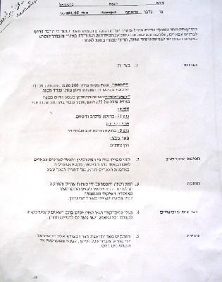
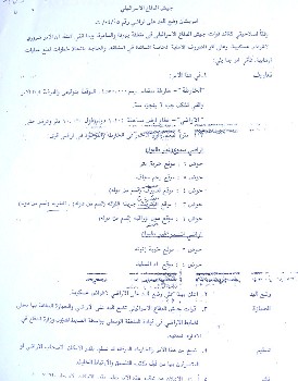
1- Military order number T/183/05 stipulates the confiscation of 292 dunums of land from Dura town (basin number 52) Ad Dahiriyatown (basin number 5) and Ar Ramadin village in the southern parts of Hebron district.  The aims of the confiscation, according to the order, is for military purposes and to build the ' security Wall' in the area.


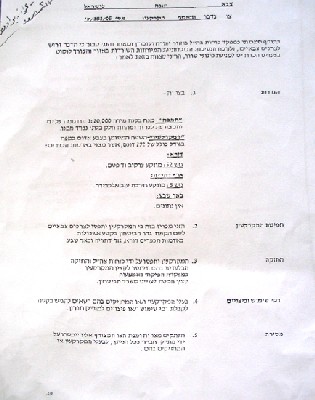
Photo 1: copy of military order No. (T/183/05)

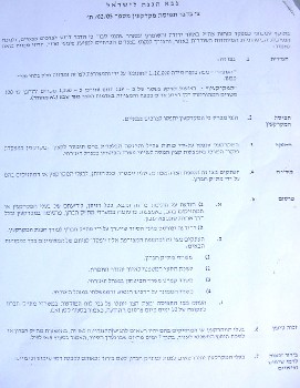
2- Military order number T/92/05 stipulates the confiscation of 7 square meters of  land scattered in the following areas: Dura town's land, basin 13 ( Qanan Rish, Khallet Abu Fasha and Khirbet Karme) and Yata town's land, basin 13 ( Khirbet Um Al Amad).  The purpose of this confiscation is to erect surveillance cameras around the settlement of Otni'el south of Hebron city which was established in 1983 and had the population of 698 settlers at the end of 2003 ( source- Foundation for Middle East Peace).


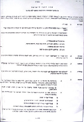
(Photo 2: copy of military order No. T/92/05))

3- Military order number T/94/05 stipulates the confiscation of 7 square meters of land from Hebron city, basin number 8 (Al Harayeq location). Again, the purpose of this confiscation is to erect surveillance cameras around the settlement of Hagai at the southern edge of Hebron city. This settlement was established in 1984 and had the population of 388 settlers by the end of 2003 (source- Foundation for Middle East Peace).


Photo 3: copy of military order No. T/942/05

Legal procedures

35 land owners and farmers from Dura, Ad Dahiriya and Ar Ramadin presented legal cases against the military order number T/183/05 through the offices of the Land Defense Committee- Hebron district authorized by the Palestinian National Authority to defend land cases in Israeli courts. Most of their target lands are located near the green line ( armistice line) where the Israelis intend to build new sections of the Annexation and Expansion Wall. According to lawyer Haitham Al Qadi the land whose total area is 292 dunums is owned by the heirs of Late Mr. Mohammed Al Haj Sabha and his brother Mr. Hussein  from Dura town as well as other farmers and land owners  from Ad Dahiriya and Ar Ramadin.

Previous land confiscation and separation orders

Earlier this year, a military order was issued by the Israeli army carrying the number of  T/05/71 ( see attached copy)  stipulating the confiscation of 689.9 dunums of lands from Ar Ramadin and neighboring  Arab Al Fureijat.


Photo 4: copy of military order number  (T/05/71))

Another two military orders were published this year for the same purpose, the first of which carries the number of  T/04/05 stipulating the confiscation and separation of 10104 dunums from the lands of As Samu', Yatta and Ad Dahiriya. The second carries the number of T/02/05 stipulating the confiscation of 119 dunums from the lands of Ad Dahiriyaas well.

 
 Photos 5 & 6: copies of the two orders numbers T/04/05 and T/02/05) & : copies of the two orders numbers T/04/05 and T/02/05)

The Wall in Hebron district: facts and figures

The estimated total length of the Wall in Hebron district ( west, south and east) is 125 km. The total area estimated to be separated behind the Wall is 403.6 KM2, while the total area estimated to be bulldozed under the route of the Wall is 12.5 KM2.  This brings to 416 KM2 the total area of lands expected to be confiscated or separated by the construction of the Wall, representing 39% of the whole area of Hebron district ( 1064 KM2), See Map 1


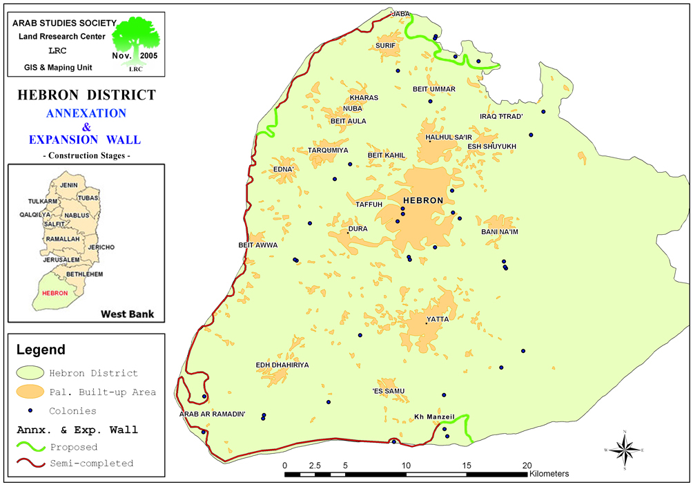
Source: LRC GIS department. GIS department.


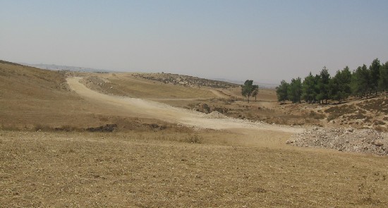
(Photo 7: works are underway to the south of Ad Dahiriya â?? Hebron )


Prepared by
The Land Research Center
LRC


Recommended For You

الاحتلال الاسرائيلي يوسع سيطرته على أراضي جبل الفرديس بمصادرة 317 دونم اخرى

by arij
June 15, 2026
0
الاحتلال الاسرائيلي يوسع سيطرته على أراضي جبل الفرديس بمصادرة 317 دونم اخرى

  في الخامس والعشرين من شهر ايار من العام 2026 نشرط سلطات الاحتلال الاسرائيلي امرا عسكريا جديدا يحمل اسم "أمر بشأن قانون الأراضي استملاك للمصلحة العامة) (يهودا والسامرة)...

Read moreDetails

بواقع 19 دونما – سلسلة من الأوامر العسكري الإسرائيلي تستهدف أراضي محافظة بيت لحم بذريعة الأغراض العسكرية

by arij
June 13, 2026
0
بواقع 19 دونما – سلسلة من الأوامر العسكري الإسرائيلي تستهدف أراضي محافظة بيت لحم بذريعة الأغراض العسكرية

سلمت سلطات الاحتلال الإسرائيلي أهالي محافظة بيت لحم سلسلة من الأوامر العسكرية لمصادرة مساحات شاسعة من الأراضي الفلسطينية في المحافظة بذريعة أغراض عسكرية. واستهدفت الأوامر العسكرية الجديدة عددا...

Read moreDetails

بمساحة اجمالية بلغت 208 دونما – سلطات الاحتلال الإسرائيلي تصادر الاراضي في محافظة طوباس لصالح معسكر اسرائيلي

by arij
June 13, 2026
0
بمساحة اجمالية بلغت 208 دونما – سلطات الاحتلال الإسرائيلي تصادر الاراضي في محافظة طوباس لصالح معسكر اسرائيلي

سلّمت سلطات الاحتلال الإسرائيلي، في السابع من حزيران 2026، أهالي مدينة طوباس شمال الضفة الغربية المحتلة أمراً عسكرياً جديداً بعنوان: "أمر بشأن وضع اليد على أراضٍ رقم 79/26/ت...

Read moreDetails

الاحتلال يرسّخ بؤرة “يتسيف” الاستيطانية عبر تخصيص 92 دونماً من أراضي بيت ساحور

by arij
June 9, 2026
0
الاحتلال يرسّخ بؤرة “يتسيف” الاستيطانية عبر تخصيص 92 دونماً من أراضي بيت ساحور

أصدر جيش الاحتلال الإسرائيلي في الخامس من شهر اذار من العام 2026 إعلاناً عسكرياً جديداً موقع من قبل ما يُسمّى بـ “قائد قوات جيش الدفاع الإسرائيلي في منطقة...

Read moreDetails

كراسة أوامر إسرائيلية جديدة تمهد لمصادرة أكثر من 20 ألف دونم في الضفة الغربية المحتلة

by arij
June 9, 2026
0
كراسة أوامر إسرائيلية جديدة تمهد لمصادرة أكثر من 20 ألف دونم في الضفة الغربية المحتلة

في الخامس من شهر اذار من العام 2026، أصدرت سلطات الاحتلال الإسرائيلي كراسة جديدة من الأوامر العسكرية التي تهدف إلى توسيع نطاق النشاطات الاستيطانية على الأراضي الفلسطينية، وذلك...

Read moreDetails
Next Post
Az Zawiya village lands under unlawful confiscation attack by the Israeli Occupation

Az Zawiya village lands under unlawful confiscation attack by the Israeli Occupation

LATEST NEWS

الاحتلال الاسرائيلي يوسع سيطرته على أراضي جبل الفرديس بمصادرة 317 دونم اخرى

الاحتلال الاسرائيلي يوسع سيطرته على أراضي جبل الفرديس بمصادرة 317 دونم اخرى

by arij
June 15, 2026
0

........................................................

بواقع 19 دونما – سلسلة من الأوامر العسكري الإسرائيلي تستهدف أراضي محافظة بيت لحم بذريعة الأغراض العسكرية

بواقع 19 دونما – سلسلة من الأوامر العسكري الإسرائيلي تستهدف أراضي محافظة بيت لحم بذريعة الأغراض العسكرية

by arij
June 13, 2026
0

........................................................

بمساحة اجمالية بلغت 208 دونما – سلطات الاحتلال الإسرائيلي تصادر الاراضي في محافظة طوباس لصالح معسكر اسرائيلي

بمساحة اجمالية بلغت 208 دونما – سلطات الاحتلال الإسرائيلي تصادر الاراضي في محافظة طوباس لصالح معسكر اسرائيلي

by arij
June 13, 2026
0

........................................................

الاحتلال يرسّخ بؤرة “يتسيف” الاستيطانية عبر تخصيص 92 دونماً من أراضي بيت ساحور

الاحتلال يرسّخ بؤرة “يتسيف” الاستيطانية عبر تخصيص 92 دونماً من أراضي بيت ساحور

by arij
June 9, 2026
0

........................................................

flag_yellow_lowEU-PfP-Logo

This website and its content were initiated in 1993 by the Applied Research Institute – Jerusalem (ARIJ) and the Land Research Center (LRC) with the support from the European Union up until 2023. Since then, the Applied Research Institute – Jerusalem (ARIJ) has taken over the continued development and maintenance of the website. The views expressed remain solely those of ARIJ) and do not necessarily reflect those of the European Union.

© 2026 Copyright | ARIJ | All Rights reserved.

No Result
View All Result
  • Home
  • Settlements
    • New Israeli Settlements
    • Settlement Expansion
  • Israeli Violations
    • Agriculture
    • Confiscation
    • Demolition
    • Environment
    • Eviction of Palestinians
    • Settlers Attacks
  • Bypass Roads
  • Israeli Plans
  • Segregation
    • Checkpoints
    • Closure
    • Separation Plans
  • Military Orders
  • Reports
    • Daily Report
    • Monthly Report
    • Quarterly Report

© 2026 Copyright | ARIJ | All Rights reserved.