On February 29, 2005, the Israeli Army released the finale diagram of the so-called security fence (Segregation Wall) that is still undergoing construction at the central and southern districts of occupied West Bank (Ramallah, Jerusalem, Bethlehem and Hebron). However, the construction of the Segregation Wall did not proceed according to the plan which was fixed following profuse number of injunctions from Israeli courts based on objections submitted by Palestinian residents at almost all the locations in order to minimize the damages to their lands and properties. Still, and in spite of all efforts, the damages were still immense at any scale and the route of the Segregation Wall was built at some areas with disregard to Israeli court orders and certainly without the interest of the unfortunate Palestinians living along the route of the Segregation Wall.
Jubara
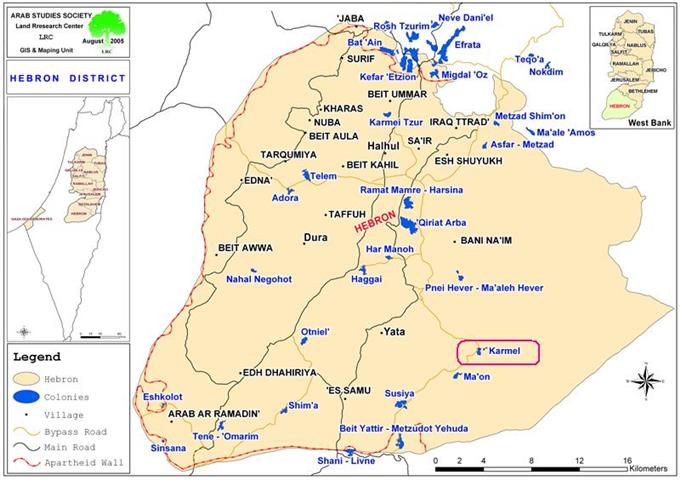
Located along the 1949 Armistice line (the Green Line) and 5 Km south of Tulkarem city, lies Khirbit (Hamlet) Jubara on 2500 Dunums of land, out of which 132 Dunums is the hamlet's built-up area, with a population of 354 (56 families). This agriculturally and game birds breeding based community relies on neighboring villages and Tulkarem city for basic life necessities such as food, services, healthcare and education.
Jubara feels the thrash of the Segregation Wall
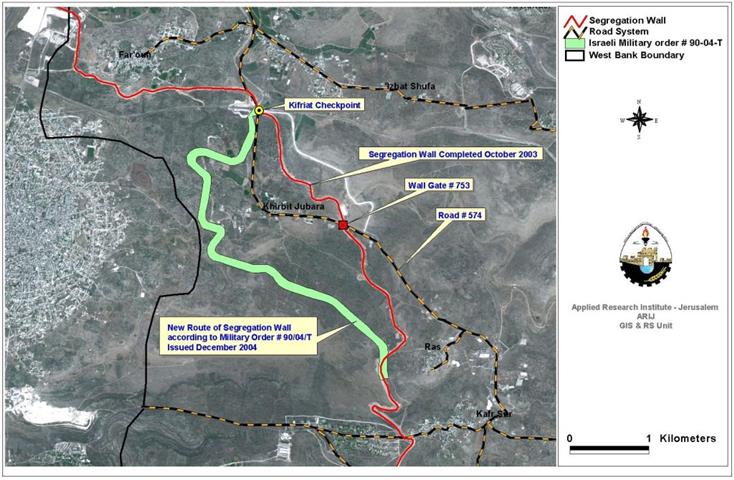
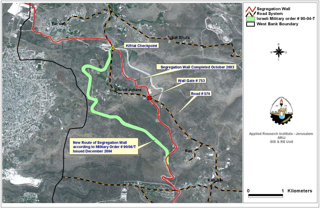
Jubara was one of the first Palestinian communities to feel the lash of the Israeli built Segregation Wall. Just at the time when the Israeli government declared its plans to build the so-called 'security fence' in the West Bank in June 2002, the Israeli destruction mechanism started mutilating Jubara's agricultural lands as a part of phase one plan of the Segregation Wall; set by the Israeli Army. By October 2003, the Israeli Army completed its work on that section of the Segregation Wall running 5.8 Km along the eastern lands of Jubara and built on 590 Dunums of its agricultural lands. Residents of Jubara filled petitions to the Israeli Supreme Court demanding to remove the Segregation Wall or to build it on the Green Line.
In December 2004 and upon the strong protests of Jubara's residents, the Israeli Army issued a military order number 90/04/T, rerouting the section of the Segregation Wall running along the eastern lands of Jubara to run along the western lands of the village and closer to the Armistice Line. However, Jubara's resident were not keen about the new Israeli order and launched yet another wave of protests and petitions, since the new route plans for the Segregation Wall comes on much more of their lands than it already has, and what is more that it separates them from the rich agricultural lands located west of the hamlet and the water springs they use for land irrigation. See Map of Jubara Village
On February 20, 2005, the Israeli Army released the final plan for the Segregation Wall route along the western West Bank border. The new route did not include any significant changes; however, it did show the adjustment made under military order number 90/04/T for Jubara hamlet. Still, the Israeli Army did nothing to comply with the military order but continued to torment Jubara's residents at the rigged Wall Gate installed at the Segregation Wall and to deny them permits to access their lands.
Again things will not be much different when and if the Israeli Army relocate the Segregation Wall; and even though the village's build-up area will no longer be located behind the Wall (inside the 'Seam Zone': the area located between the Segregation Wall and the Armistice Line), Jubara's residents will still be alienated from their olive groves, which will require them to obtain special permits from the Israeli civil administration in order to cross to their lands.
So far, the Israeli Army uprooted and damaged thousands of olive trees to construct the standing Segregation Wall and upon the realignment process thousands more of olive trees will face the hard steel of the Israeli Army machines.
What is the status now in Jubara?
The current standing Israeli Segregation Wall caused to cut off a major Palestinian road (road number 574), which is considered an artery road for many small Palestinian communities who seek various services in Tulkarem city. The Segregation Wall has caused to isolate Jubara hamlet in an enclave and cut off residents' from the nearby villages from their agricultural lands. The only access available to Jubara's residents in the enclave is the Kafriat checkpoint located north of Jubara, right on the point where the Segregation Wall cut off route 574. Today, the Kafriat checkpoint signifies frustration and psychological torment to Jubara's residents and to those wishing to cross to their lands located in the enclave. Closures, delays and mood swings of Israeli soldiers are the dominant status at the Israeli checkpoint, even the existing underpass located at the same area where the checkpoint is located; is subjected to restrictions similar to those at the checkpoint, particularly at the time of security alerts and during Jewish holidays.
Ultimately, one fact remain conclusive; Jubara's residents are prisoners trapped in an Israeli declared 'closed military area' and any of them wishes to continue living in what became a 'seam zone' must obtain a special permit issued from the Israeli civil administration. Residency permits are compulsory for all those living in Jubara over the age of 12 and for those who are less must be accompanied by their parents. This also goes to Palestinians from nearby villages (Ar Ras, Far'oun, and Kufr Sur) who own agricultural lands and wishes to look after these lands located within Jubara enclave. The majority of lands trapped within Jubara's enclave belong to residents of other villages (Ar Ras, Far'oun, and Kufr Sur). See map of Jubara Village
Ras village: 8000 Dunums of cultivated land belong to Ras village is located in the Jubara enclave, the only access to these lands is through Wall Gate number 753 (also known as the eastern gate) in the Segregation Wall. The Gate is used also by school children from Jubara to get to their schools in the nearby villages. The Wall Gate has Israeli restrictions for use and is often subjected to Israeli soldiers timing and not to a fixed schedule.
Far'oun village: 4000 Dunums are located in Jubara enclave where the only access to these lands is conditional by possession of an Israeli issued permit to pass through the Kafriat checkpoint.
Kufr Sur: 2350 Dunums of cultivated land is isolated in the enclave, only 30% of those who own lands in Jubara have received access permits to get to their lands through the Kafriat checkpoint and only during the olive harvest season.
The Israeli issued permits are not easy to obtain, residents of Jubara and landowners from the nearby villages are requested to submit Israeli authenticated documents of residency and land ownership proof to obtain a permit that is issued on a temporary base and must be renewed periodically. Only landowners are eligible to receive permits to cross to their lands; the landowners are usually the seniors in their families and incapable to look after the lands. Issuance of permits by the Israeli civil administration has always been a fluctuating process, but complaints from residents and landowners were many since the beginning of this year, as the number of these permits issued has been steadily declining to an even 'no issuance' status between April and September 2005.
In October 2005, the Israeli civil administration recommenced permit issuance process with 40 permits issued out of the original number (350 – 400); those entitled to permits. At all times, residents of Jubara and those who own lands in the enclave are reminded constantly that the permit they obtain to live in the enclave or to reach their lands is by no means entitle them to any right in the enclave. The sentence that is written on the back of the permits they receive reads; {this permit does not entitle the bearer the right of ownership or the right to live legally in the seam zone}.
What Israel wants is voluntarily transfer of Palestinians!
Jubara is one of the 30 Palestinian communities entrapped in what Israel calls the 'Seam Zone'; an area located between the Segregation Wall and the 1949 Armistice Line (the Green Line). These communities with the holding population of 40,000+ are completely isolated and separated from the West Bank area and entrance to these communities is only possible through gates and checkpoints controlled by Israeli and conditional with the possession of an Israeli issued permit. Public services, proper medical treatment, and education among other necessities, which are no longer available to these communities who are gradually feeling that they are being squeezed into the Israeli plan that pushes them to the bottleneck of the enclave and out of their lands.
Prepared by:
The Applied Research Institute – Jerusalem