Introduction
In August 2005, the Israeli bulldozers resumed the Segregation Wall constructions in Biddu village, northwest Jerusalem city. Construction works has been stopped since June 2004 when the Israeli High Court ordered to halt the constructions in 30 Kilometers section of the Segregation Wall that was planned to be constructed in 9 Palestinian villages located north and northwest of Jerusalem, which are: Beit Surik, Biddu, Qattanah, Al Qubeibeh, Beit 'Anan, Beit Leqia, Beit Duqqu, Beit Ijza, Nabi Samuel and Beit Iksa.
Chronology of events in Biddu Village
During the past years, the residents of Biddu received military orders handed by the Israeli Occupation Forces to seize land for the construction of the Segregation Wall in Biddu village. The Following table shows the total number of military orders that were served to residents of Biddu village during the years 2003- 2004. (See translation of military orders in Appendix one and table one)
Table 1: Military orders served to Biddu Village
|
Date |
Number of military order |
Land confiscation (km²) |
Land isolated (km²) |
Length |
Location |
|
December 30, 2003 |
108/03/T |
0.12 |
0.48 |
2 km |
Southeast of the Biddu village |
|
October 15, 2004 |
75/04/T |
0.084 |
0.76 |
1.24 km |
Southwest of the Biddu village |
|
October 18, 2004 |
76/04/T |
0.039 |
0.031 |
650 m |
Southeast of the Biddu village |
|
December 27, 2004 |
96/04/T |
0.071 |
0.65 |
1.076 km |
Northeast of the Biddu village |
Source: ARIJ DataBase 2005
-
In 2003 military order number 108/03/T was issued to confiscate agricultural lands in the southeastern part of the village. The wall was about to run for 2 km length along the village's lands, and to confiscate about 120 dunums for the Wall route and isolate another 480 dunums of the village's lands behind the Wall.
-
During the early months of 2004 constructions in Biddu wall commenced when the Israeli bulldozers started bulldozing lands for laying the infrastructure of the Segregation Wall in the village.
-
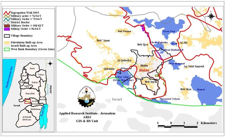
In October 2004, the Israeli forces served out residents of Biddu and the nearby villages (mentioned earlier) military orders number #04/75/T, n0 04/76/T and n0 04/87/T stating a new route of the wall to be constructed on lands of those Palestinians villages.
-
Military order number 76/04/T targeted the southeastern part of the village and situated the Wall east of the previously announced one to be further from Biddu built-up area. The Wall running through Biddu land will be 650m long over 39 dunums and isolating 31 dunums of Biddo lands.
-
Military order number 75/04/T targeted the southwestern part of the village and situated the Wall between the illegal settlement of Har Adar and the villages of Biddo and Beit Surik. The Wall cutting through Biddo will be 1.24m long over 84 dunums and isolating 760 dunums of Biddo lands.
-
On December 27, 2004, the Israeli occupation forces served out Biddu villagers another military order numbered (04/96/T) which targeted the northeastern part of Biddo and situated the Wall between the illegal Israeli settlements of Giviat Hadasha, Giviat Hadasha B and Givat Ze'ev and the Palestinian villages of Biddo, Beit Ijza and Beit Duqqu. The Wall cuts through Biddo with a length of 1.076 km over 71 dunums and isolating another 650 dunums of Biddo lands.
-
According to military orders number 75/04/T, 04/96/T and 76/04/T, the total area that will be isolated from Biddo village will be 1441 dunums that is 27% of the village's lands. See map of previous military orders

-
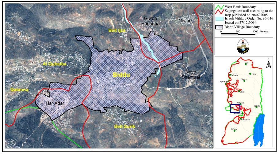
In February 2005 the Israeli ministry of defense updated the Segregation Wall route in the West Bank. According to this plan, the Wall will cut Biddo lands from the northeastern and southwestern sections, and comes closer to the built up areas isolating 780 dunums from the northeastern section and 1083 dunums from the southwestern section, that is a total of 1863 dunums, 35% of the village's lands.
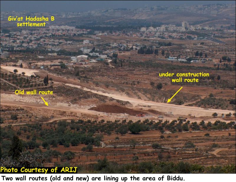
- Today, a partially completed Wall section is seen from the eastern part of the village. See Photo 1
Conclusion
The construction of the Segregation Wall is leading to ethnic cleansing of the Palestinians and is subjecting an entire population to aggressive collective punishment. The Wall proved to be a land grab tool where it confiscated vast areas of land and isolated them behind the Wall off reach of their Palestinian owners who need special permits to access their agricultural lands behind the Wall. The Wall in Biddo is just few meters away from the built up area isolating nearly 35% of the village's lands and placing the fertile agricultural lands on the other side of the Wall. The isolated land will be used for the settlement expansion of Har Adar from the southwest, Neve Shamual from the east and Givat Hadasha and Givat Hadasha B from the northeast.
These Israeli acts constitute a blatant violation of the Human Rights, International Covenants, Laws and Conventions, among which is:
Hague Convention IV, Article 23 (G), which clearly states that the occupying power is forbidden 'to destroy or seize the enemy's property, unless such destruction or seizure be imperatively demanded by the necessities of war.'
The Geneva Conventions of 1949, Article 53 which states that: 'Any destruction by the Occupying Power of real or personal property belonging individually or collectively to private persons, or to the State, or to other public authorities, or to social or cooperative organizations, is prohibited, except where such destruction is rendered absolutely necessary by military operations.'
Appendix One: Military orders served to residents of Biddo on December 30, 2003
Military order no. (108/03/T Judea & Samaria 2003):
|
– Translation – Israel Defense Forces Order to Seize lands n0 108/03/T According to my authorities as a Military Chief Commander in the Region of Judea and Samaria, and as I believe that it is imperative for military reasons due to the special security situation in the region, I order the following: 1. The 'Map' signed in scale 1: 1000 and attached to the order is an essential part of this order. The 'Lands' : An area of land which is 334.3 dunums(5385 meter long and 60-65 meters wide) marked in red in the map :
2. I announce by that the above mentioned lands are seized for military reasons . 3. The IDF seize the lands and have an absolute control over it that is given to the officer of the central command officer of lands who is responsible in the ministry of defense. 4. These copies are to be given by the District Co-ordination Office 'The DCO' of Ramallah to the owners of land. 5. Copies are found with maps for those who are interested in the following places :
6. The owners of land have the right to go to the DCO in Ramallah in order to get more information about their right of land use expenses and compensation. 7. The Validity of this order starts at the date signed till 31/12/2005 8. The name of this order is: Order to seize lands # 108/03/T (Judea & Samaria ) 2003.
Mosheh Kaplenski
|
|
Military order no. (75/04/T Judea and Samaria):
|
– Translation – Israel Defense Forces Order to Seize lands n0 75/04/T According to my authorities as a Military Chief Commander in the Region of Judea and Samaria, and as I believe that it is imperative for military reasons due to the special security situation in the region, I order the following: 1. The 'Map' signed in scale 1: 10000 and attached to the order is an essential part of this order. The 'Lands' : An area of land which is 336.1 dunums(220 meter long and 3815 meters wide) marked in red in the map :
2. I announce by that the above mentioned lands are seized for military reasons . 3. The IDF seize the lands and have an absolute control over it that is given to the officer of the central command officer of lands who is responsible in the ministry of defense. 4. These copies are to be given by the District Co-ordination Office 'The DCO' of Ramallah to the owners of land. 5. Copies are found with maps for those who are interested in the following places :
6. The owners of land have the right to go to the DCO in Ramallah in order to get more information about their right of land use expenses and compensation. 7. The Validity of this order starts at the date signed till 31/12/2007 8. The name of this order is: Order to seize lands # 75/04/T (Judea & Samaria ) 2004.
Mosheh Kaplenski |
|
Military order no. (76/04/T Judea & Samaria 2004):
|
– Translation – Israel Defense Forces Order to Seize lands n0 76/04/T According to my authorities as a Military Chief Commander in the Region of Judea and Samaria, and as I believe that it is imperative for military reasons due to the special security situation in the region, I order the following: 1. The 'Map' signed in scale 1: 10000 and attached to the order is an essential part of this order. The 'Lands' : An area of land which is 263.7 dunums marked in red in the map :
2. I announce by that the above mentioned lands are seized for military reasons . 3. The IDF seize the lands and have an absolute control over it that is given to the officer of the central command officer of lands who is responsible in the ministry of defense. 4. These copies are to be given by the District Co-ordination Office 'The DCO' of Ramallah to the owners of land. 5. Copies are found with maps for those who are interested in the following places :
6. The owners of land have the right to go to the DCO in Ramallah in order to get more information about their right of land use expenses and compensation. 7. The Validity of this order starts at the date signed till 31/12/2007 8. The name of this order is: Order to seize lands # 76/04/T (Judea & Samaria ) 2004.
Mosheh Kaplenski |
|
Military order no. (96/04/T Judea & Samaria 2004):
|
– Translation – Israel Defense Forces Order to Seize lands n0 96/04/T According to my authorities as a Military Chief Commander in the Region of Judea and Samaria, and as I believe that it is imperative for military reasons due to the special security situation in the region, I order the following: 1. The 'Map' signed in scale 1: 5,000 and attached to the order is an essential part of this order. The 'Lands' : An area of land which is 71.9 dunums marked in red in the map :
2. I announce by that the above mentioned lands are seized for military reasons . 3. The IDF seize the lands and have an absolute control over it that is given to the officer of the central command officer of lands who is responsible in the ministry of defense. 4. These copies are to be given by the District Co-ordination Office 'The DCO' of Ramallah to the owners of land. 5. Copies are found with maps for those who are interested in the following places :
6. The owners of land have the right to go to the DCO in Ramallah in order to get more information about their right of land use expenses and compensation. 7. The Validity of this order starts at the date signed till 31/12/2007 8. The name of this order is: Order to seize lands # 96/04/T (Judea & Samaria ) 2004.
Mosheh Kaplenski |
|
Prepared By
The Applied Research Institute – Jerusalem
ARIJ