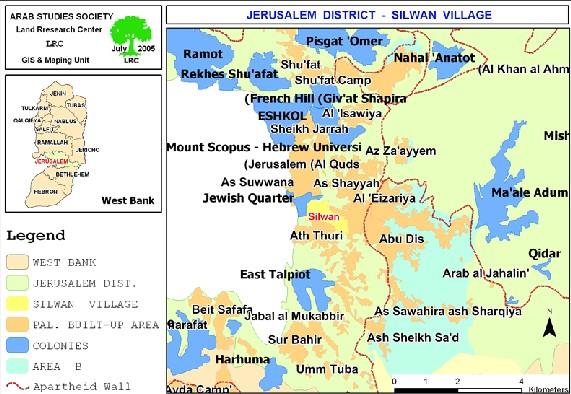
Location and population
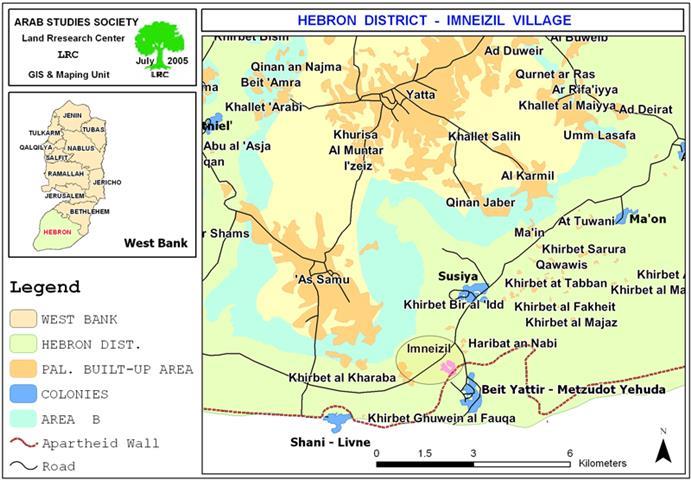
Imneizil village is located 10 km to the southeast of Yatta town in Hebron Governorate. It is strangled between two Israeli settlements inhabited by right-wing Jewish extremists: the settlements of Susiya (established in 1983 and houses a total population of 643 settlers according to 2003 statistics); and Beit Yattir or Mezadot Yehuda settlement (established in 1980 and houses a total population of 412 settlers according to 2003 statistics) source: Foundation for Middle East Peace.) The aforementioned settlements were built on lands originally owned by Palestinains from Yatta town and Imneizil village but were confiscated from them.

( Map 1: Location of Imneizil village)
(To the north can be seen the bypass road No. 317 and the settlement of Susiya; to the east and south is the road to Beit Yattir settlement ) (To the north can be seen the bypass road No. 317 and the settlement of Susiya; to the east and south is the road to Beit Yattir settlement
The total population of Imneizil village is about 500 inhabitants who are totally dependent on agriculture and animal breeding as a main source of income. They live a semi nomadic life. The village is formed of the following families: Rashid, Abu Samra, Nawaja', Mur, Abu Ali, Abu Eid and Ismirat. A basic mixed school, clinic and mosque are available in the village.
The village area
Imneizil's total area is 3021 dunums, including the lands of the nearby Khirbet Haribat an Nabi which is affiliated to Imneizil. This area is divided as followed: 136 dunums for Imneizil built-up area; 48.5 dunums for Haribat an Nabi built-up area and the remaining lands are agricultural and grazing zones.
Imneizel and the Wall
Three weeks ago, the Israeli army circulated military orders to Palestinian land owners stipulating the confiscation of hundreds of dunums from the lands of Imneizil villages and other villages in the area, including the nearby Khirbet of Haribat an Nabi for the purpose of constructing the Segregation Wall. Land owners were given only one week to present their objections to the Israeli military committee at Beit El. According to one owner, Mr. Musalam Salameh Hasan Rashid, 65 years old, the time given wasn't enough for objection and the opportunity is lost.
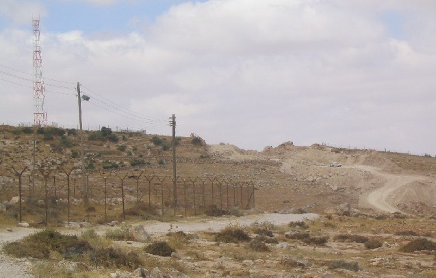
( Photo 1: Wall works outside the fence of Yattir colony- Photo courtesy of LRC )
On April 8, 2005, the Israeli occupation army announced the confiscation and separation of more than 10677 dunums from the lands of Palestinians located along the 1967 borders starting from the village of Al Burj to the southwest of Dura and reaching to Imneizil village south of Yatta town and passing through the lands of ad Dahiriya, ar Ramamdin, as Samu' and Yatta. Thess latest confiscation orders came as part of the aforementioned ones. So far, about 400 dunums of Imneizel village have been devastated under the route of the Wall and 70 olive trees at the age of 15 years were either uprooted or destroyed.
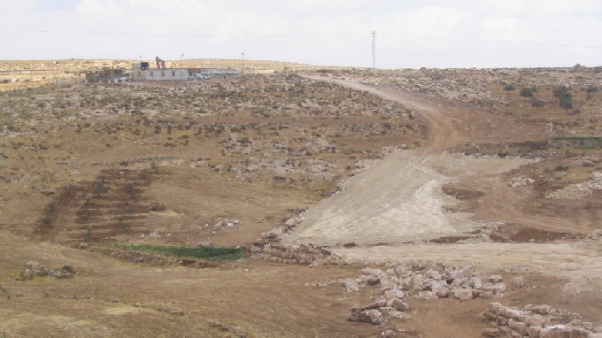
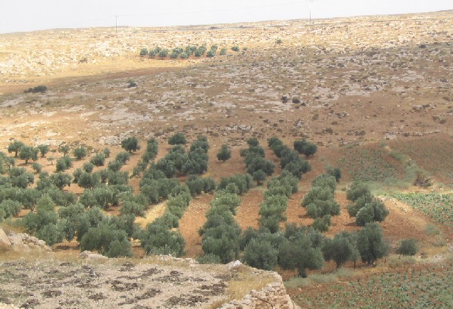
( Photo 2: Imneizil- Hebron – Some of the uprooted and replanted
olive trees can be seen in the left – Photo courtesy of LRC)
In an interview with LRC field worker, Mr. Musalam Hasan went on to say the following: 'A week before work commenced, a number of Israeli army officers came and took us on a tour around the village informing us of the 'projected' path of the Wall on the ground. However, when actual works began, every thing was changed and the path was pushed deep inside our lands'. After my trees had been uprooted an officer asked me: do you want money for the uprooted trees? I replied, even if you give me a piece of gold for each single leave I will not takeit because I am not the one who sells his lands and his honor.'..
Mr. Hasan concluded: ' Now, we are threatened with evacuation because we are besieged from all directions and our lands are being taken. We are being pushed to a desperate situation'.
A totally besieged village
Imneizil village is surrounded from all directions by Israeli settlements and bypass roads. From the north, the northwest and the west is bypass road number 317; from the northeast is the settlement of Susiya, from the east is the bypass road leading to Mesadot Yehda settlement and Arad city inside Israel; and finally from the south is the settlement of Mesadot Yehda and the 1948 borders. Once the Wall constructions are completed, the village will become strangulated between the Jaws of the Wall from south, the bypass road and the Israeli settlements from north, west and east.
The only entrance to the village is through the bypass road leading to the Mesadot Yehda settlement and Arad. Before reaching Imneizil, Palestinians have to pass through a military checkpoint where no body can cross ( insider or outsider ) without having a valid permit from the Israeli military. Despite its location within the West Bank proper, Israelis consider this checkpoint 'a border' as there are no other checkpoints before reaching Arad and Beer Shiva . Therefore, passing measures at this checkpoint are very strict. To cope with this situation, the citizens of Imneizil are obliged to take dirt detours to enter or exit the village.


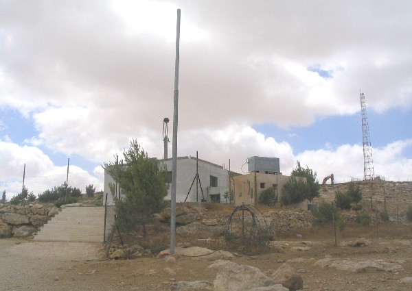
(Photo 5 & 6: Imneizil- Hebron- One of the modest houses of
Imneizil and it poor infrastructure. Photo courtesy of LRC)
Losses inflicted on the village as a result of Wall construction
1. The devastation and separation of more than 3600 dunums of lands mostly used as arable lands cultivated with cereals or used as pastures. By so doing, the village will be totally stripped off its land and deprived of its only source of living as a preliminary step towards final dismissal and extraction.
2. The village will witness further deterioration in the educational and health services since all school and clinic staff are from the towns of Yatta and as Samu' who will face difficulties in reaching their workplaces inside the village. Also, students after grade nine have to travel 10 km each way in order to reach their schools in the towns of Yatta and as Samu'. This daily trip exposes them to danger at the hands of extremist colonists wandering in the area or at the hands of army patrols monitoring any body crossing the surrounding bypass roads. As a result, risk is high and school dropping is expected to increase. On the other hand, the already excavated path of the Wall is only 15 meters from the edge of the school in Imneizil. This reality creates an atmosphere of continued tension unrest and fear amongst pupils.
( Photo 4: : Imneizil- Hebron – in the front are the school and mosque. In the back is the fence of Yattir settlement and its communication tower. A big hammer can be seen working just behind the school. Photo courtesy of LRC )
1. The village will be totally deprived of its water resources once the wall construction has been finished. That is, one well serving the school and mosque has already been destroyed under the path of the Wall. Another five wells will be either destroyed or separated behind the Wall. It is worth mentioning that the village has no water network whatsoever and is unconnected with any water supply line because of the Israeli refusal in the past. On most part, the people are dependent on collected winter rainfall fro domestic and agricultural uses. On small part, they bring water by mobile tanks from Yatta and as Samu' at very high price (up to 20 NIS per one cubic meter).
2. Hundreds of olive, grape and almond trees are expected to be destroyed, uprooted or stolen at the hands of Israelis.The following is a list of land owners affected by the Wall in Imneizil:
|
No. |
Name of owner |
Area in dunums |
|
1 |
Musalm Salameh Hussein Ihrizat |
100 |
|
2 |
The heirs of Salim Salameh Hussein Ihrizat |
100 |
|
3 |
The heirs of HajSulieman Hussein Ihrizat |
100 |
|
4 |
The heirs of Haj Ali Hussein Ihrizat |
100 |
|
5 |
The heirs of haj Abed Hussein Ihrizat |
100 |
|
6 |
The heirs of Salim Hasan rashid Ihrizat |
100 |
|
7 |
The heirs of Mahmud hasan Rashid Ihrizat |
100 |
|
8 |
The heirs of Sulieman Abed Mur |
100 |
|
9 |
The heirs of Ibraahim Abed Mur |
100 |
|
10 |
The heirs of Ahmad Abdallah Mur |
1100 |
|
11 |
The heirs of Mohammed Sulieman Abu Ali |
200 |
|
12 |
The heirs of AbdelQader Sulieman Abu Ali |
200 |
|
13 |
The heirs of Salamn Sulieman Abu Ali |
200 |
|
14 |
Mohammed salamn Abu Eid |
Non Available |
|
15 |
Ahamd Salman Abu Eid |
Non Available |
|
16 |
Musalam Khalil Abu Eid |
Non Available |
|
17 |
Mohammed Abu Baker Ismirat |
Non Available |
|
18 |
Musa Abu Baker Ismirat |
Non Available |
|
19 |
Abed Abu Baker Ismirat |
Non Available |
|
20 |
Salman Abu Baker Ismirat |
Non Available |
|
21 |
Abdallah Hammad Abu Zimi' |
Non Available |
|
22 |
Mohammed Ibrahim Al Hureini and brothers |
1000 |
|
|
Total |
3600 |
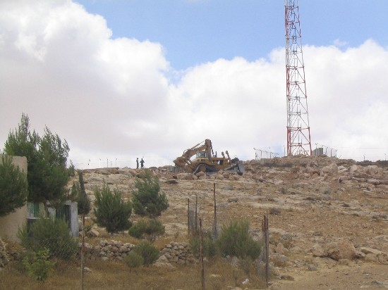
Photo 7: Imneizil- Hebron – an Israeli bulldozers leveling the land for the Wall construction
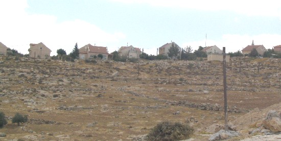
Photo 8: Some Palestinian houses inside the settlement of Beit Yattir ' Mezadot Yehuda'.
(Photo courtesy of LRC )
Prepared by
The Land Research Center
LRC