• About The Project
  • Palestine in Century
  • Selected Maps
  • Glossary
  • About ARIJ
  • About LRC
  • By Year
    • Case Studies By Year
    • Daily Report By Year
Saturday, June 6, 2026
POICA
No Result
View All Result
  • Home
  • Settlements
    • New Israeli Settlements
    • Settlement Expansion
  • Israeli Violations
    • Agriculture
    • Confiscation
    • Demolition
    • Environment
    • Eviction of Palestinians
    • Settlers Attacks
  • Bypass Roads
  • Israeli Plans
  • Segregation
    • Checkpoints
    • Closure
    • Separation Plans
  • Military Orders
  • Reports
    • Daily Report
    • Monthly Report
    • Quarterly Report
No Result
View All Result
POICA
No Result
View All Result

A New Confiscation Order for the Segregation Wall in Beit Jala

June 10, 2004
in Military Orders
A New Confiscation Order for the Segregation Wall in Beit Jala

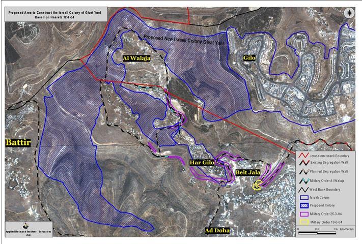
The 50 Km2 Israeli crisscross Segregation Wall to enclave Bethlehem district as a part of the disengagement plan to isolate and dissect the Palestinian territories, just had another piece of it exposed as the ''Segregation Wall formation''. The Wall became more visible with regard to its path and destructive consequences to the very social fabric of the Palestinian communities it penetrates.


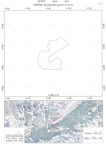
On June 2, 2004, residents of Beit Jala town, ''received'' a new Israeli military order declaring the Israeli Army decision to confiscate 11.8 dunums for the construction of the Segregation Wall which is penetrating the lands of Beit Jala from east to west. See map of military order as distributed by the Israeli army.


The Israeli confiscation order that was issued in May 19, 2004 and tossed by the Israeli Army at the targeted area held tag number 04/57/T. The following is a translation of the military order:


  Military Order Translation   Israel Defense Forces

 Order to Seize lands # 04/57/T 


According to my jurisdictions as a Military Chief Commander in the Region of Judea and Samaria, and as I believe that it is imperative for military purposes, I order the following:


Key Terms


1. With regard to:


''Map''– Map drawing scale of 1/ 10,000 signed by my self and considered inseparable part of the order at hand.


The Lands


An area of land size of 11, 8 Dunums (250 meters length & 22-74 meters width) marked in red in the map illustrating Beit Jala's land.


Beit Jala (Shomeh Block)


Bloc 28049: parcels:134/ 129-130/ 109-117/ 106/ 90-92


Land Seize


2. I declare that the above-mentioned lands seized for military purposes.


Possession


3. The Israeli Defense Army declares absolute possession of stated lands and authorizes it to the land officer at the central command headquarters under the Ministry of Defense.


Issuance


4. Copies of the order at hand are to be delivered to the District Coordination Office (DCO) in Bethlehem who will in its turn pass the order on to the landowners.


Allocation


5 (A)-1: All means to notify the Landowners of the land seizure; either through the District Coordination Office (DCO) in Bethlehem or other mean is considered valid.


5 (A)-2: A tour/ meeting will be arranged through the District Coordination Office (DCO) in Bethlehem to tour the designated land. 


5 (B) Copies of the order at hand along with the attached map are to be located at the following places for public reference:

  • District Coordination Offices (DCO) in Bethlehem

  • Offices of the Judicial Advisor for the Region of Judea and Samaria

  • Office of the Ministry of Defense delegation officer at the civil administration

  • Office of the Absentee and public lands contact officer at the civil administration.

To File an Objection


6. land owner are entitled to file an objection regarding the seizure order to the legal counselor throughthe District Coordination Office (DCO) in Bethlehem within 7 days of the tour (5 (A)-2).


Compensation Inquiries


7. For inquiries regarding compensations, the landowners are to contact the District Coordination Office (DCO) in Bethlehem.


Order Effect


8. The order will go in effect at the time of its signing to December 31, 2005


Identify


9. The order at hand will be identified as ''Land Seize Order # 04/57/T (Judea and Samaria) 2004-5764''. 

Mosheh Kaplenski
Chief Commander of the Israel Defense Forces in Judea & Samaria
                                Signature


Prepared by:
The Applied Research Institute – Jerusalem


Recommended For You

سلطات الاحتلال الإسرائيلي بصدد الاستيلاء على موقع قبر النبي صموئيل شمال غرب مدينة القدس

by arij
May 23, 2026
0
سلطات الاحتلال الإسرائيلي بصدد الاستيلاء على موقع قبر النبي صموئيل شمال غرب مدينة القدس

 نشرت سلطات الاحتلال الإسرائيلي في الثامن عشر من شهر أيار من العام 2026 اعلانا مفاده الاستيلاء على الأراضي الفلسطينية في قرية النبي صموئيل شمال غرب القدس المحتلة. وجاء...

Read moreDetails

إقامة منطقة عسكرية عسكرية داخل أراضي (أ) في جنين

by arij
May 19, 2026
0
إقامة منطقة عسكرية عسكرية داخل أراضي (أ) في جنين

   في السابع من شهر أيار من العام 2026، وزعت سلطات الاحتلال الإسرائيلي أمرا عسكريا جديدة على أهالي مدينة جنين يقضي بمصادرة 7.2 دونما من الأراضي الفلسطينية في...

Read moreDetails

“بمساحة اجمالية 177 دونما من أرضي البيرة وبيتين”, طريق استيطاني لخدمة البؤر الاستيطانية في محافظة رام الله

by arij
May 18, 2026
0
“بمساحة اجمالية 177 دونما من أرضي البيرة وبيتين”, طريق استيطاني لخدمة البؤر الاستيطانية في محافظة رام الله

في الحادي عشر من شهر أيار من العام 2026, نشرت دائرة أراضي إسرائيل اعلانا جديدا يقضي بمصادرة المزيد من الأراضي الفلسطينية في محافظة رام الله لأغراض استيطانية في...

Read moreDetails

“في خدمة مستوطنة ناحال حيلتس”, طريق استيطاني إسرائيلي جديد على أراضي بتير وبيت جالا في محافظة بيت لحم

by arij
May 18, 2026
0
“في خدمة مستوطنة ناحال حيلتس”, طريق استيطاني إسرائيلي جديد على أراضي بتير وبيت جالا في محافظة بيت لحم

تواصل سلطات الاحتلال الإسرائيلي إحكام سيطرتها على المزيد من الأراضي الفلسطينية في الضفة الغربية المحتلة، وهذه المرة من خلال استهداف أراضي محافظة بيت لحم. ففي السادس والعشرين من...

Read moreDetails

مناطق نفوذ المستوطنات ودورها في إعادة تشكيل الجغرافيا الفلسطينية

by arij
April 23, 2026
0
مناطق نفوذ المستوطنات ودورها في إعادة تشكيل الجغرافيا الفلسطينية

أصدرت سلطات الاحتلال الإسرائيلي في العاشر من شهر نيسان 2026 الكراسة رقم (273)، وهي وثيقة تضم مجموعة من المناشير والأوامر والتعيينات الإسرائيلية المتعلقة بالجوانب الأمنية والعسكرية والإدارية، إضافة...

Read moreDetails
Next Post
Plans for a new Israeli “South Jerusalem”  Grabbing Palestinian lands from Al Walaja, Battir, and Beit Jala

Plans for a new Israeli "South Jerusalem" Grabbing Palestinian lands from Al Walaja, Battir, and Beit Jala

LATEST NEWS

سلطات الاحتلال الإسرائيلي بصدد الاستيلاء على موقع قبر النبي صموئيل شمال غرب مدينة القدس

سلطات الاحتلال الإسرائيلي بصدد الاستيلاء على موقع قبر النبي صموئيل شمال غرب مدينة القدس

by arij
May 23, 2026
0

........................................................

إقامة منطقة عسكرية عسكرية داخل أراضي (أ) في جنين

إقامة منطقة عسكرية عسكرية داخل أراضي (أ) في جنين

by arij
May 19, 2026
0

........................................................

الآثار كأداة للضم الزاحف: مشروع القانون الإسرائيلي لإعادة هندسة الجغرافيا والهوية في الضفة الغربية

الآثار كأداة للضم الزاحف: مشروع القانون الإسرائيلي لإعادة هندسة الجغرافيا والهوية في الضفة الغربية

by arij
May 23, 2026
0

........................................................

النكبة الفلسطينية في ذكراها الثامنة والسبعين: من التطهير العرقي إلى الإبادة وإعادة هندسة الجغرافيا الفلسطينية 

النكبة الفلسطينية في ذكراها الثامنة والسبعين: من التطهير العرقي إلى الإبادة وإعادة هندسة الجغرافيا الفلسطينية 

by arij
May 18, 2026
0

........................................................

flag_yellow_lowEU-PfP-Logo

This website and its content were initiated in 1993 by the Applied Research Institute – Jerusalem (ARIJ) and the Land Research Center (LRC) with the support from the European Union up until 2023. Since then, the Applied Research Institute – Jerusalem (ARIJ) has taken over the continued development and maintenance of the website. The views expressed remain solely those of ARIJ) and do not necessarily reflect those of the European Union.

© 2026 Copyright | ARIJ | All Rights reserved.

No Result
View All Result
  • Home
  • Settlements
    • New Israeli Settlements
    • Settlement Expansion
  • Israeli Violations
    • Agriculture
    • Confiscation
    • Demolition
    • Environment
    • Eviction of Palestinians
    • Settlers Attacks
  • Bypass Roads
  • Israeli Plans
  • Segregation
    • Checkpoints
    • Closure
    • Separation Plans
  • Military Orders
  • Reports
    • Daily Report
    • Monthly Report
    • Quarterly Report

© 2026 Copyright | ARIJ | All Rights reserved.