• About The Project
  • Palestine in Century
  • Selected Maps
  • Glossary
  • About ARIJ
  • About LRC
  • By Year
    • Case Studies By Year
    • Daily Report By Year
Thursday, May 28, 2026
POICA
No Result
View All Result
  • Home
  • Settlements
    • New Israeli Settlements
    • Settlement Expansion
  • Israeli Violations
    • Agriculture
    • Confiscation
    • Demolition
    • Environment
    • Eviction of Palestinians
    • Settlers Attacks
  • Bypass Roads
  • Israeli Plans
  • Segregation
    • Checkpoints
    • Closure
    • Separation Plans
  • Military Orders
  • Reports
    • Daily Report
    • Monthly Report
    • Quarterly Report
  • Home
  • Settlements
    • New Israeli Settlements
    • Settlement Expansion
  • Israeli Violations
    • Agriculture
    • Confiscation
    • Demolition
    • Environment
    • Eviction of Palestinians
    • Settlers Attacks
  • Bypass Roads
  • Israeli Plans
  • Segregation
    • Checkpoints
    • Closure
    • Separation Plans
  • Military Orders
  • Reports
    • Daily Report
    • Monthly Report
    • Quarterly Report
No Result
View All Result
POICA
No Result
View All Result

Twenty Three Houses Threatened With Demolition in Hebron District

March 30, 2000
in Military Orders
Twenty Three Houses Threatened With Demolition in Hebron District


The Hebron District is located in the southernmost portion  of the West Bank, 36 km south of Jerusalem City. The 1997 population census data  estimated the total population of the Hebron District at 389,014; with 119,230  people, or 31% of the district, residing in Hebron City, 35% of the population  living in other municipalities, 31% living in rural areas, and 3% of the population  living in refugee camps.

In the last few months, 23 buildings in Hebron district got  orders to halt construction and thus are threatened with demolition. The Israeli  authorities sent the owners' notifications saying that their houses or buildings  are not legal, so they didn't have the permission to live there or build new houses.  These notifications said that they had about one month to stop building or leave  their homes, then after that duration there would be a trial. However the date  of sending these notification was in February and March of this year.

The owners are: Deab Alhalika, Jamal Mrayyesh, Fareed Al-Junaidi,  Jehad Ismael, Ali Ibrahim, Belal Issa, Yosef Issa, Nofal Hoshia, Jebrin Hassan,  Issa Ahmaro, Salem Harb, Azmi Msalam, Sliman Al Najajda, Issa Za'aqiq, Ahmad Alqawasmi,  Ishaq Alqawasmi, Mohamad Ahmaro, Jehad Hamdan, Ata Abed Al-Jawad Jaber, Jamal  Ibrahem Khalil Moqbil, Raed Moqbil Khalil Moqbil, Owad Faris Shoqdam, Mohamed  Mosa Shoqdam.

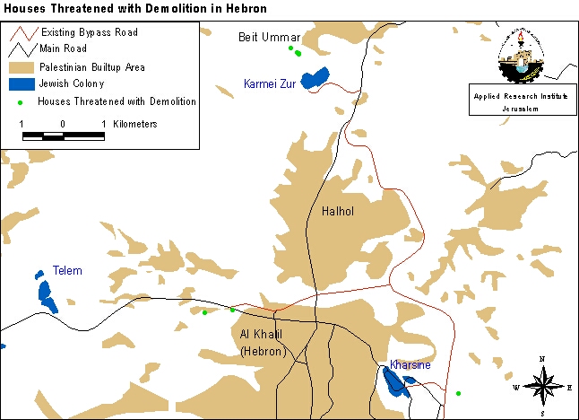
The threatened buildings are distributed in Hebron City, Dura,  Edna, Biet Ummar, Halhol, Khirbet Ed Dirat, Khirbet Karmel. The map shows some  of those buildings (see map ).

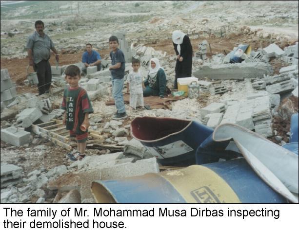
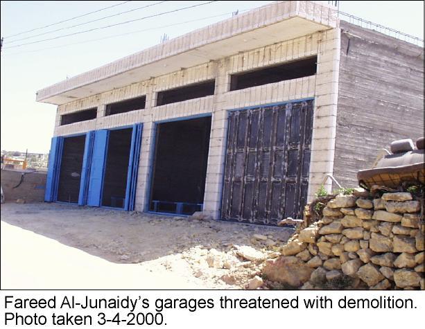
In Hebron City, one of the residents was Fareed Al-Junaidi.  He is a mechanic and has four garages with a total area of 210 m² (see  photo). The notification is for these garages that are the only source of  income for his family, which includes five persons. In that neighborhood there  are two other houses threatened to be demolished. One of them is for Ahmad Alqawasmi,  which is a new house consisting of two floors. Another one is for a handicap  man, Jamal Mrayyesh; this one is an old house consisting of one floor. Ata Abed  Al-Jawad Jaber, whose family includes six persons, received a notification to  stop the building of his new house whose total area is 150 m². This is the  third time that he receives such a notice. In the two previous times his house  was demolished (see photo). He also has irrigation pools  which were used for agriculture but they too have been demolished (see  photo). Ata has had to endure all these hardships simply because his house  lies about one kilometer east of Kharsina settlement (see map).


In Biet Ummar, which lies 10 kilometers north of Hebron City,  four houses got notifications to halt construction. One is for Jamal Ibrahem Khalil  Moqbil whose house is 108m² and his family includes four persons (see  photo). The second house is for Raed Moqbil Khalil Moqbil. The area of the  house is 114 m², and his family includes five persons (see  photo). The third is for Awad Faris Shoqdam. His house is a meager 90m²  and his family includes three persons. The fourth house is for Mohamed Mosa Shoqdam,  which has a total area of 120m² and shelters five persons. All these houses  lie in area C, but they also lie less than 700 meters away from the Israeli settlement of Karmei Zur. The settlement lies south of the houses and spans over 204 dunums  of Beit Ummar land (see photo).


These activities by the Israeli government are in total violation  of international law as well as the standing agreements between Israel and the  PNA. The fact that Israel continues in its policy of depopulating Palestinian  areas lying in Area C (especially those close to Jewish settlements) shows that it  intends to transform the West Bank to suite its ambitions while at the same time  allowing for the continuous growth of its settlements.


Prepared by:
The Applied Research Institute – Jerusalem

Recommended For You

سلطات الاحتلال الإسرائيلي بصدد الاستيلاء على موقع قبر النبي صموئيل شمال غرب مدينة القدس

by arij
May 23, 2026
0
سلطات الاحتلال الإسرائيلي بصدد الاستيلاء على موقع قبر النبي صموئيل شمال غرب مدينة القدس

 نشرت سلطات الاحتلال الإسرائيلي في الثامن عشر من شهر أيار من العام 2026 اعلانا مفاده الاستيلاء على الأراضي الفلسطينية في قرية النبي صموئيل شمال غرب القدس المحتلة. وجاء...

Read moreDetails

إقامة منطقة عسكرية عسكرية داخل أراضي (أ) في جنين

by arij
May 19, 2026
0
إقامة منطقة عسكرية عسكرية داخل أراضي (أ) في جنين

   في السابع من شهر أيار من العام 2026، وزعت سلطات الاحتلال الإسرائيلي أمرا عسكريا جديدة على أهالي مدينة جنين يقضي بمصادرة 7.2 دونما من الأراضي الفلسطينية في...

Read moreDetails

“بمساحة اجمالية 177 دونما من أرضي البيرة وبيتين”, طريق استيطاني لخدمة البؤر الاستيطانية في محافظة رام الله

by arij
May 18, 2026
0
“بمساحة اجمالية 177 دونما من أرضي البيرة وبيتين”, طريق استيطاني لخدمة البؤر الاستيطانية في محافظة رام الله

في الحادي عشر من شهر أيار من العام 2026, نشرت دائرة أراضي إسرائيل اعلانا جديدا يقضي بمصادرة المزيد من الأراضي الفلسطينية في محافظة رام الله لأغراض استيطانية في...

Read moreDetails

“في خدمة مستوطنة ناحال حيلتس”, طريق استيطاني إسرائيلي جديد على أراضي بتير وبيت جالا في محافظة بيت لحم

by arij
May 18, 2026
0
“في خدمة مستوطنة ناحال حيلتس”, طريق استيطاني إسرائيلي جديد على أراضي بتير وبيت جالا في محافظة بيت لحم

تواصل سلطات الاحتلال الإسرائيلي إحكام سيطرتها على المزيد من الأراضي الفلسطينية في الضفة الغربية المحتلة، وهذه المرة من خلال استهداف أراضي محافظة بيت لحم. ففي السادس والعشرين من...

Read moreDetails

مناطق نفوذ المستوطنات ودورها في إعادة تشكيل الجغرافيا الفلسطينية

by arij
April 23, 2026
0
مناطق نفوذ المستوطنات ودورها في إعادة تشكيل الجغرافيا الفلسطينية

أصدرت سلطات الاحتلال الإسرائيلي في العاشر من شهر نيسان 2026 الكراسة رقم (273)، وهي وثيقة تضم مجموعة من المناشير والأوامر والتعيينات الإسرائيلية المتعلقة بالجوانب الأمنية والعسكرية والإدارية، إضافة...

Read moreDetails
Next Post
Israeli Occupation Forces Demolishes Three Houses in Al Essawiyah Village

Israeli Occupation Forces Demolishes Three Houses in Al Essawiyah Village

LATEST NEWS

سلطات الاحتلال الإسرائيلي بصدد الاستيلاء على موقع قبر النبي صموئيل شمال غرب مدينة القدس

سلطات الاحتلال الإسرائيلي بصدد الاستيلاء على موقع قبر النبي صموئيل شمال غرب مدينة القدس

by arij
May 23, 2026
0

........................................................

إقامة منطقة عسكرية عسكرية داخل أراضي (أ) في جنين

إقامة منطقة عسكرية عسكرية داخل أراضي (أ) في جنين

by arij
May 19, 2026
0

........................................................

الآثار كأداة للضم الزاحف: مشروع القانون الإسرائيلي لإعادة هندسة الجغرافيا والهوية في الضفة الغربية

الآثار كأداة للضم الزاحف: مشروع القانون الإسرائيلي لإعادة هندسة الجغرافيا والهوية في الضفة الغربية

by arij
May 23, 2026
0

........................................................

النكبة الفلسطينية في ذكراها الثامنة والسبعين: من التطهير العرقي إلى الإبادة وإعادة هندسة الجغرافيا الفلسطينية 

النكبة الفلسطينية في ذكراها الثامنة والسبعين: من التطهير العرقي إلى الإبادة وإعادة هندسة الجغرافيا الفلسطينية 

by arij
May 18, 2026
0

........................................................

flag_yellow_lowEU-PfP-Logo

This website and its content were initiated in 1993 by the Applied Research Institute – Jerusalem (ARIJ) and the Land Research Center (LRC) with the support from the European Union up until 2023. Since then, the Applied Research Institute – Jerusalem (ARIJ) has taken over the continued development and maintenance of the website. The views expressed remain solely those of ARIJ) and do not necessarily reflect those of the European Union.


© 2026 Copyright | ARIJ | All Rights reserved.

No Result
View All Result
  • Home
  • Settlements
    • New Israeli Settlements
    • Settlement Expansion
  • Israeli Violations
    • Agriculture
    • Confiscation
    • Demolition
    • Environment
    • Eviction of Palestinians
    • Settlers Attacks
  • Bypass Roads
  • Israeli Plans
  • Segregation
    • Checkpoints
    • Closure
    • Separation Plans
  • Military Orders
  • Reports
    • Daily Report
    • Monthly Report
    • Quarterly Report

© 2026 Copyright | ARIJ | All Rights reserved.