The Palestinian village of Nahalin is 20 kilometers southwest of Bethlehem city {Figure 1}, with a population of 5,000. The original area of the village was 12,000 dunums, but since 1967 60% of this area has been confiscated by the Israeli authorities in order to construct more settlements. }, with a population of 5,000. The original area of the village was 12,000 dunums, but since 1967 60% of this area has been confiscated by the Israeli authorities in order to construct more settlements.
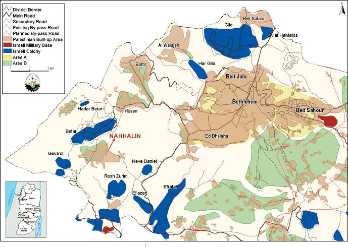
Figure 1: Location of Nahalin village
Nahalin, and the nearby villages of Wadi Foqin and Husan, are under increasing threat from the expansion of the surrounding Israeli settlements, especially Betar settlement, which lies just north of the village. To the south, Nahalin is bordered by the Gush Etzion settlements (Etzion block), covering around 50% of the land that originaly belonged to the village. The block includes the military settlement of Geva'ot and the agricultural settlement of Rush Tzurim {Figure 2}.}.

Figure 2: Satellite Image showing the expansion of surrounding settlements.
The main problem, however, is the growing Israeli settlement of Betar, founded in 1990 on the agricultural land of Nahalin. Betar, an urban settlement, houses 2,200 families, with a total population of 8,500 settlers on 1,075 dunums of land {Figure 3 & Figure 4}. The smaller sister settlement of Betar Illite was established at the same time, on a further 875 dunums of land. The Israeli authorities have also confiscated 4,000 dunums of land north of Betar. The official reason for the confiscation was expansion, yet most likely the aim is creating a new and seperate settlement. & }. The smaller sister settlement of Betar Illite was established at the same time, on a further 875 dunums of land. The Israeli authorities have also confiscated 4,000 dunums of land north of Betar. The official reason for the confiscation was expansion, yet most likely the aim is creating a new and seperate settlement.
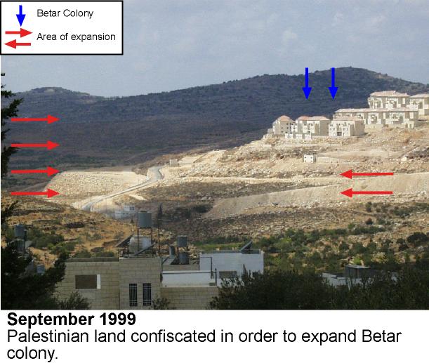
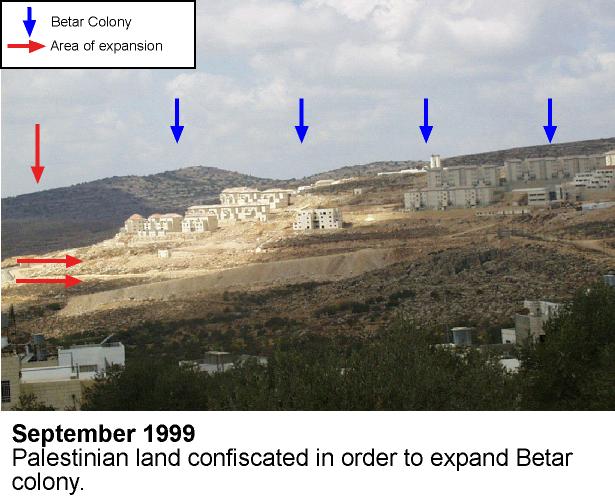
Figure 3 & Figure 4: Continuous expansion of Betar settlement
Through the recent expansion of settlements and by-pass roads, and the restriction of Palestinian land, the Israeli authorities have violated the peace agreement of Oslo II (1995) which stated that neither side could change the status of the West Bank and the Gaza Strip. The confiscation of land is thus illegal, but the Israeli government ignores this. One method of confiscation is to use land previously declared as 'No Man's Land` for security purposes. Confiscation can also be carried out under the guise of protecting the environment and then, after the passing of some time, the same land is used for building purposes. A good example of such a tactic has been the case of Abu Ghneim (Har Homa) . Alternatively, the land can simply be bought by the Israeli authorities, who, having vast financial resources, are able to purchase Palestinian land by using fake affidavit (a written statement made after an official oath to tell the truth for use as proof in a court of law). This does not bode well for the future of Nahalin, which in just five years time could be completely encircled by settlements.
The physical presence of the Betar settlement in such close proximity to Nahalin has caused tension. The villagers' growing anxiety from Israeli activities stems from the fact that Nahalin was the sight of a horrible massacre during the Intifada. In 1989, six Palestinians were killed by Israeli soldiers and many more were injured. The settlements also have a negative effect on the younger generation. For example, above the playground of Nahalin Secondary School are electricity cables running towards Betar, dangerously close to where the children play.
The social impact of Betar on Nahalin has been extremely detrimental. The exploitation of limited clean water resources by the settlers leaves the local population to face increasingly dangerous water shortages {Figure 5 & Figure 6}. & }.


Figure 5 & Figure 6: Polluted Palestinian spring. .
Furthermore, the settlement's sewage plant is unable to cope with the demands of the settlement. Consequently, each season the excess waste, that is stored in large tanks, is emptied down into the valley and towards the village of Nahalin .This has contaminated natural water springs serving Nahalin and resulted in the spread of epidemic diseases {Figure 7}. }.
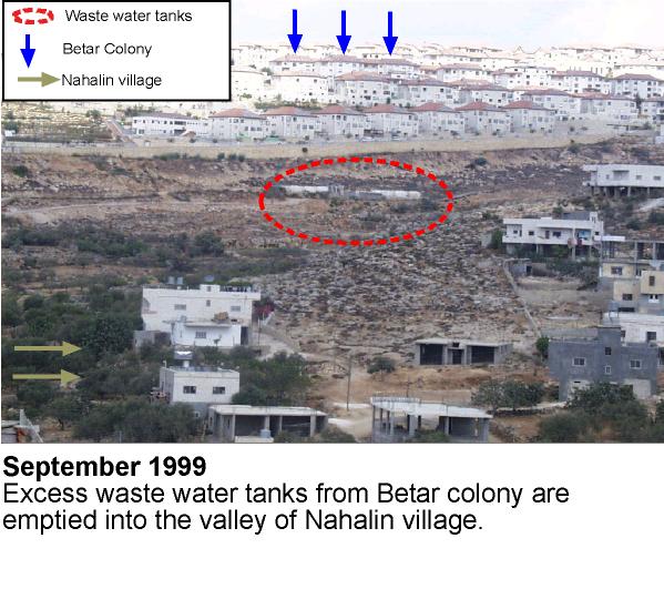
Figure 7: Settlement Waste water
Moreover, the settlers' attitude to the local land creates tension. At times, they have uprooted trees or damaged them with chemicals, and burned crops on Palestinian land. Such actions, in addition to the dumping of waste water, are designed to harass the local people in an attempt to drive them away. In 1995, the Israeli authorities uprooted 2,286 trees belonging to people from the villages of Husan and Nahalin, in order to construct a by-pass road between Betar and Gush Etzion. Not only will this road damage the environment, but it will also effectively cut off Nahalin from Bethlehem, consolidating the hold of Jewish settlers on the area. The general policy of land confiscation in order to build settlements and by-pass roads has resulted in the confinement of villages such as Nahalin. The boundaries set by Israel for Nahalin leave the village with no potential for future expansion. It is extremely difficult for Palestinians to gain building permits. Thus, the Palestinian people are being forced to use vital agricultural land in order to extend the village, ultimately resulting in the creation of an urban rather than agricultural community.
The consequence of land confiscation and the building of settlements will be the complete isolation of the village of Nahalin. Cut off from its cultural and historical roots, and faced with the threatening presence of the ever-growing settlements, the future looks increasingly uncertain.
Prepared by:
The Applied Research Institute – Jerusalem