• About The Project
  • Palestine in Century
  • Selected Maps
  • Glossary
  • About ARIJ
  • About LRC
  • By Year
    • Case Studies By Year
    • Daily Report By Year
Saturday, March 28, 2026
POICA
No Result
View All Result
  • Home
  • Settlements
    • New Israeli Settlements
    • Settlement Expansion
  • Israeli Violations
    • Agriculture
    • Confiscation
    • Demolition
    • Environment
    • Eviction of Palestinians
    • Settlers Attacks
  • Bypass Roads
  • Israeli Plans
  • Segregation
    • Checkpoints
    • Closure
    • Separation Plans
  • Military Orders
  • Reports
    • Daily Report
    • Monthly Report
    • Quarterly Report
No Result
View All Result
POICA
No Result
View All Result

Strangulation of El Janiya village

May 7, 1999
in Settlement Expansion
Strangulation of El Janiya village


El Janiya village is one of the rural communities in Palestine spreading over 25,000 dunums of land. It is located west of Ramallah city with a population of approximately 827. El Janiya village is surrounded by several small communities which depend mainly on agriculture and livestock for living ( Figure 1) .) .

Figure 1: Location Map of El Janiya village


The Israeli colonization in El Janiya village started as early as 1983. Presently, five Israeli colonies, namely Dolev, Talmon-1, Talmon-2, Talmon-3 (Figure 2), and the under construction settlement Talmon-4, have been established in the eastern parts of the village. The total pouplation of the five Israeli colonies reaches approximately 1200 of ultra-orthodox Jews (Figure 3). About 20,000 dunums of the village best agricultural lands were lost for the construction of these colonies. Lands were confiscated under the pretext of being 'state -owned land'.

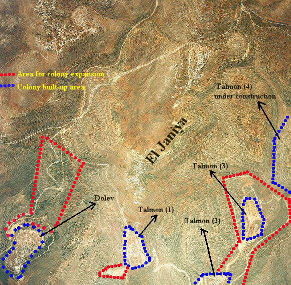
Figure 2: Strangulation of the eastern part of El Janiya village


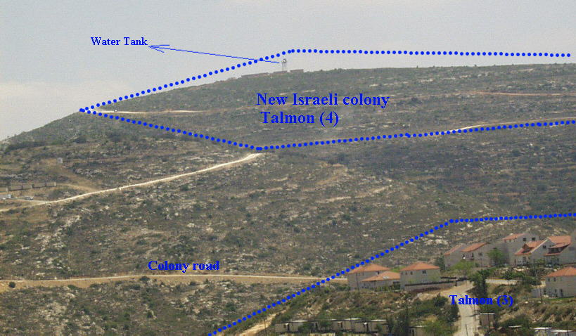
Figure 3: Photo illustrating the new outpost


Talmon-4 is merely an extension of the Talmon settlement, about a kilometer away. It is planned that Talmon-1, -2, -3, and -4 will form a single built-up area surrounding the valley of olive trees cultivated by Palestinian villagers. The Israeli bulldozers have almost completed leveling the ground for the new outpost which consists of two families, four caravans, a water tank, and a guard post . It is one of 20 new outposts created since signing Wye River Memorandum.

Table1: Israeli Settlements Constructed on El Janiya Land

Israeli Settlement

Number of
Families

Founding
Date

Population
Type

Empty Housing
Units

Units under
Construction

Built-up Area
in dunums

Dolev

118

Jan-83

Religious

11

24

225

Talmon-1,-2,-3 ,-4

120

Mar-89

Religious

47

27

469


A little further, bulldozers shuttle to and fro clearing the ground for the new road which will bypass the neighboring Palestinian villages, to enable the colonists living in the four sectors of Talmon to get to Jerusalem in half an hour. For the construction of that road, colonists uprooted more than 500 trees (Figure 4).

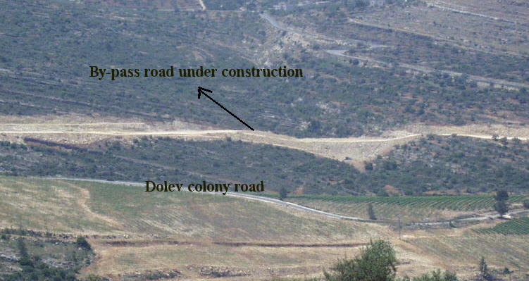
Figure 4: Construction of a new by-pass road


Lands used for the construction of these colonies and several settlement roads are located within the village boundary of El Janiya. They are also part of the main rangelands in El Janiya which provide feed for livestock. The closure of these lands not only deprives the Palestinians of a major source of income, but also threatens the biodiversity in that area. The construction of these colonies has also affected the growth of Palestinian communities in the eastern direction. Presently, only 500 dunums of the total area of El Janiya village are left for population natural growth.

It is of important weight to mention that waste water generated from Israeli colonies flows into the nearby valleys and damages the agricultural lands which belong to El Janiya village (Figure 5).

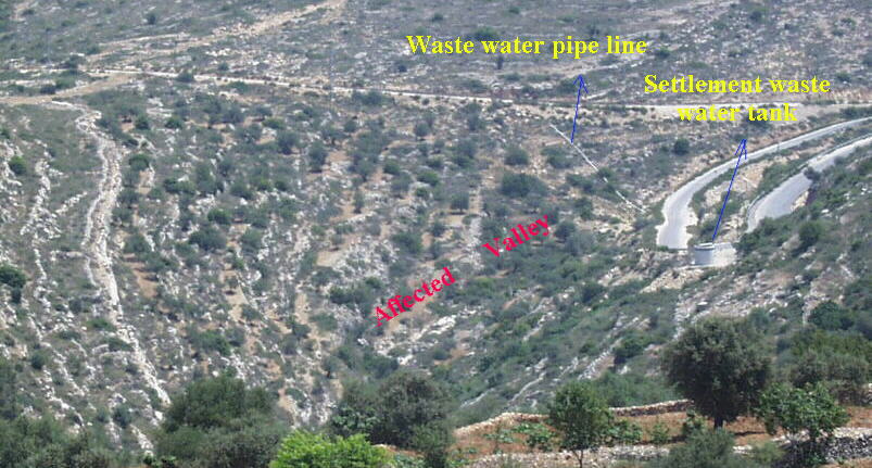
Figure 5: Affected Palestinian Agricultral land


Settlement construction in the Occupied Territories continues to go before and after Israel's general elections (May 17th 1999) which to a large extent has a decisive influence on creating facts on the ground before a final agreement with the Palestinians on the status of the area.


Prepared by:
The Applied Research Institute – Jerusalem

Recommended For You

على ما مساحته 1006.4 دونما من أراضي بلدة يانون
“سلطات الاحتلال الإسرائيلي تشرع بتغيير نفوذ بؤرة استيطانية في الضفة الغربية المحتلة”

by arij
March 14, 2026
0
على ما مساحته 1006.4 دونما من أراضي بلدة يانون  “سلطات الاحتلال الإسرائيلي تشرع بتغيير نفوذ بؤرة استيطانية في الضفة الغربية المحتلة”

في الثاني عشر من شهر شباط من العام 2026, نشر رئيس قسم الاستيطان والتنظيم فيما يسمى "بالإدارة المدنية الإسرائيلية", الذراع الأيمن لحكومة الاحتلال الإسرائيلية اعلانا مفاده " اعلان...

Read moreDetails

حين تتقلص الخريطة: تسارع غير مسبوق في توسّع المستوطنات الإسرائيلية خلال عام 2025

by arij
February 16, 2026
0
حين تتقلص الخريطة: تسارع غير مسبوق في توسّع المستوطنات الإسرائيلية خلال عام 2025

مقدمة: - ان السياسة الاستيطانية الإسرائيلية في الضفة الغربية المحتلة هي واحدة من أكثر القضايا التي تقف عائقا في تحقيق سلام عادل وقابل للحياة في الأراضي الفلسطينية المحتلة....

Read moreDetails

حين يصبح الاستيطان سياسة دولة: 26 ألف وحدة جديدة تهدد الضفة الغربية

by arij
November 27, 2025
0
حين يصبح الاستيطان سياسة دولة: 26 ألف وحدة جديدة تهدد الضفة الغربية

في ظلّ صمتٍ دوليٍّ متزايد، يكشف معهد الأبحاث التطبيقية – القدس (أريج) عن طرح سلطات الاحتلال الإسرائيلي مخططات بناء استيطانية لأكثر من 26 ألف وحدة استيطانية جديدة في...

Read moreDetails

Expansion of Gilo Settlement: A Strategic Plan to Isolate Bethlehem and Undermine Palestinian Rights

by arij
May 12, 2025
0
Expansion of Gilo Settlement: A Strategic Plan to Isolate Bethlehem and Undermine Palestinian Rights

The Israeli Civil Administration has announced a new settlement expansion plan—No. 101-1284223—which outlines the construction of 1,990 new settlement units on approximately 175.9 dunums of land extending towards...

Read moreDetails

إسرائيل تمضي قدمًا في مخطط استيطاني جديد على أراضي مدينة بيت جالا، في انتهاك للقانون الدولي وحرمان الفلسطينيين من أراضيهم

by arij
April 29, 2025
0
Israel Advances Settlement Plan on Ancient Olive Groves on lands of Beit Jala city, Violating International Law and depriving Palestinians their lands

  في أواخر شهر شباط من العام 2025، صادقت دولة الاحتلال الإسرائيلي على مخطط استيطاني جديدة لبناء حي سكني للمستوطنين على مساحة 22.2 دونما من الأراضي الفلسطينية لتابعة...

Read moreDetails
Next Post
Reactivating E-1 Plan of Maale Adumim Settlement

Reactivating E-1 Plan of Maale Adumim Settlement

LATEST NEWS

سلطات الاحتلال الإسرائيلي تستهدف قرية الجيب بأمر عسكري جديد

سلطات الاحتلال الإسرائيلي تستهدف قرية الجيب بأمر عسكري جديد

by arij
March 17, 2026
0

........................................................

على ما مساحته 1006.4 دونما من أراضي بلدة يانون  “سلطات الاحتلال الإسرائيلي تشرع بتغيير نفوذ بؤرة استيطانية في الضفة الغربية المحتلة”

على ما مساحته 1006.4 دونما من أراضي بلدة يانون
“سلطات الاحتلال الإسرائيلي تشرع بتغيير نفوذ بؤرة استيطانية في الضفة الغربية المحتلة”

by arij
March 14, 2026
0

........................................................

الاحتلال الإسرائيلي يستهدف مشاريع تنموية في قرية جورة الشمعة جنوب شرق بيت لحم

الاحتلال الإسرائيلي يستهدف مشاريع تنموية في قرية جورة الشمعة جنوب شرق بيت لحم

by arij
March 14, 2026
0

........................................................

سلطات الاحتلال الإسرائيلي تستخدم الأوامر العسكرية لتعمق المشروع الاستيطاني في الضفة الغربية المحتلة

سلطات الاحتلال الإسرائيلي تستخدم الأوامر العسكرية لتعمق المشروع الاستيطاني في الضفة الغربية المحتلة

by arij
February 26, 2026
0

........................................................

flag_yellow_lowEU-PfP-Logo

This website and its content were initiated in 1993 by the Applied Research Institute – Jerusalem (ARIJ) and the Land Research Center (LRC) with the support from the European Union up until 2023. Since then, the Applied Research Institute – Jerusalem (ARIJ) has taken over the continued development and maintenance of the website. The views expressed remain solely those of ARIJ) and do not necessarily reflect those of the European Union.

© 2026 Copyright | ARIJ | All Rights reserved.

No Result
View All Result
  • Home
  • Settlements
    • New Israeli Settlements
    • Settlement Expansion
  • Israeli Violations
    • Agriculture
    • Confiscation
    • Demolition
    • Environment
    • Eviction of Palestinians
    • Settlers Attacks
  • Bypass Roads
  • Israeli Plans
  • Segregation
    • Checkpoints
    • Closure
    • Separation Plans
  • Military Orders
  • Reports
    • Daily Report
    • Monthly Report
    • Quarterly Report

© 2026 Copyright | ARIJ | All Rights reserved.