
Isolating over 3000 dunums in Nablus Eastern parts
Location: the villages of Yanoun, Rujib, and BeitFurik Perpetrators: the Israeli Occupation Army andItmar colonists Victims:...
عزل أكثر من 3000 دونماً لصالح مستعمرة ” ايتمار”
الانتهاك: مواصلة عزل 3000 دونم من أراضي الريف الشرقي. الموقع: قرى وبلدات (اليانون، روجيب، بيت فوريك)...
« La Diplomatie des Murs »
La technique d’Israël d’imposer des faits sur le terrain pour saboter la solution à deux Etats
Le 1er janvier 2012, le Premier Ministre israélien Benjamin Netanyahou a révélé l'intention de son pays...

“The Diplomacy of Walls”
Israel’s way to impose facts on the Ground to stamp out the Two State Solution
On January 1, 2012, the Israeli Prime Minister Benjamin Netanyahu revealed Israel’s intention to build a...
Israel resumes construction of the segregation Wall in Al-Walajeh Village Northwest of Bethlehem Governorate
Al-Walajeh, a Palestinian community located about 4 kilometers northwest of Bethlehem governorate and 8.5 km southwest...
Plowing Palestinian Lands in Al Walaja – Bethlehem Governorate
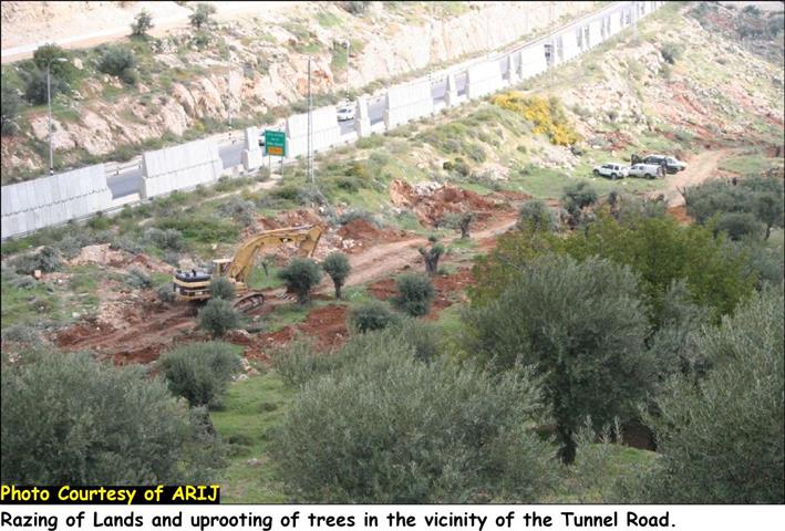
Violation: plowing a 100-meter-long sector of land in preparation for the construction of the segregation wall....
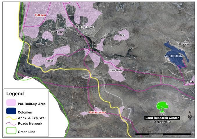
The Israeli Occupation Initiate Construction of the Segregation Wall around Jubara
Violation: the Israeli Occupation begins the construction of the northern and western sections of the segregation...
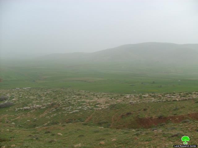
Suffocating Al Bqe’a south of ‘Atouf village
Violation: digging a 5-km-long trench in Al Bqe’a. Location: Al Bqe’a – southern ‘Atouf. Date: early...
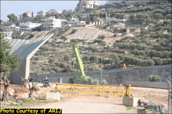
Construction returns to the Segregation Wall in Beit Jala city
On the 23rd of January, 2011, the Israeli Occupation machinery backed by Israeli Border Police commenced...
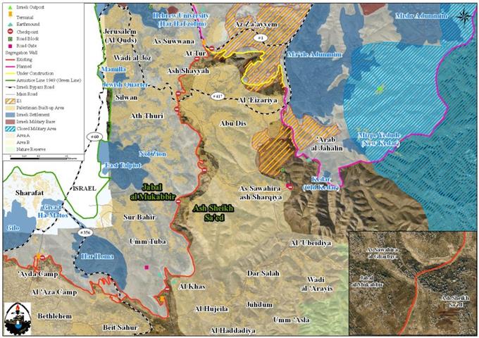
The Israeli Supreme Court Ratified the Route of the Israeli Segregation Wall in Al-Sheikh Sa’ed Village South of the City of Jerusalem
Overview Al Sheikh Sa’ed is a small Palestinian village located on the southeastern outskirts of Jerusalem...
The Israeli Supreme Court ratifies a new adjustment to the apartheid wall path introducing more difficulties to Palestinians
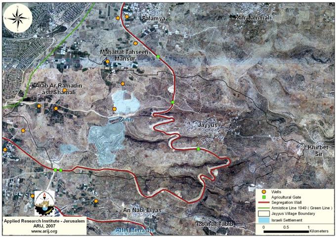
Violation: the Israeli Supreme Court agrees on the adjustments made on the wall track western Jayyus....
The Wall ensures the segregation of Beit Iksa village and the isolation of its lands
Background Beit Iksa is a Palestinian village located 9 kilometers northwest of the city of Jerusalem...
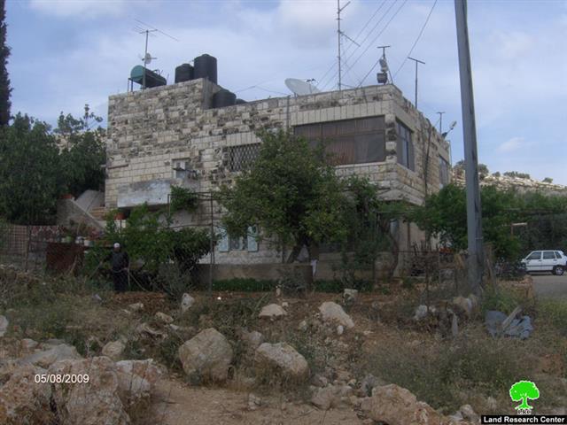
Houses Located in Jerusalem While its Residents Hold West Bank IDs
Three families from Al Suleiman clan are currently living in total isolation due to the Israeli...
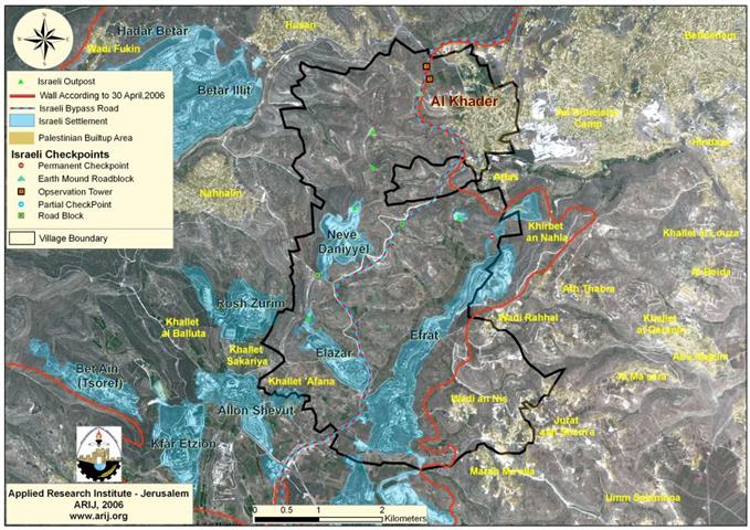
Al Khader Village to lose its lands for the construction of the Israeli Segregation Wall
Al Khader Village: Location and Population The village of Al Khader is located some 4.5 kilometers...
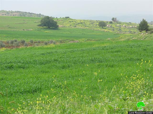
Palestinian Farmers prevented from tending their lands in the eastern side of the Segregation Wall’s path
Farmers in Faqqu'a Village, Jenin district are still suffering from the Israeli measures preventing them from...
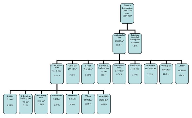
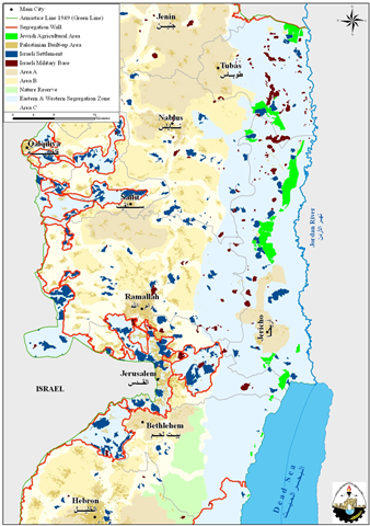
The Eastern Segregation Plan: Facts & Impacts
Geography The Eastern strip of the West Bank encompasses the middle and lower parts of the...
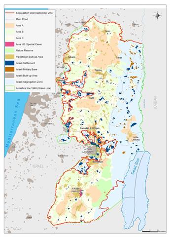
ARIJ Fact Sheet: The Israeli Segregation Plan in the Occupied Palestinian Territory
On September 12, 2007 the Israeli government published another revised route of the Segregation Wall in...
The Segregation Wall, an unlawful measure of Land Grab !!!
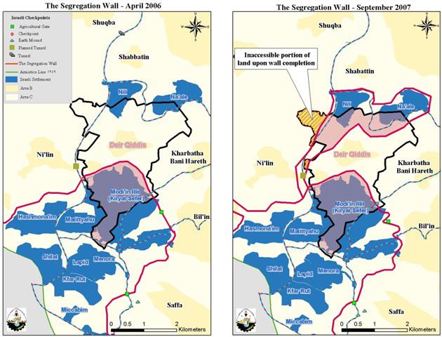
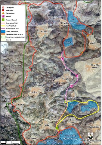
“The Case of Deir Qiddis village”
Deir Qiddis, Location and Population The Palestinian village of Deir Qiddis is located 16 kilometers to...
According to the Israeli Ministry of Defense
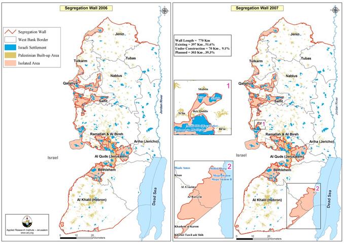
” The Israeli Army increases the Segregation Wall Length and thus the Segregated Zone area in the West Bank”
After one and a half year of releasing the updated version of the revised Segregation Wall...
It Will Take One More Year Because of Legal & Environmental Obstacles
” The Construction of the Israeli Apartheid Segregation Wall will be completed by 2010
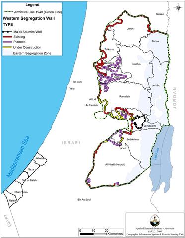
THE SEGREGATION WALL IN THE WEST BANK The Israeli Segregation Wall is an Israeli project started...
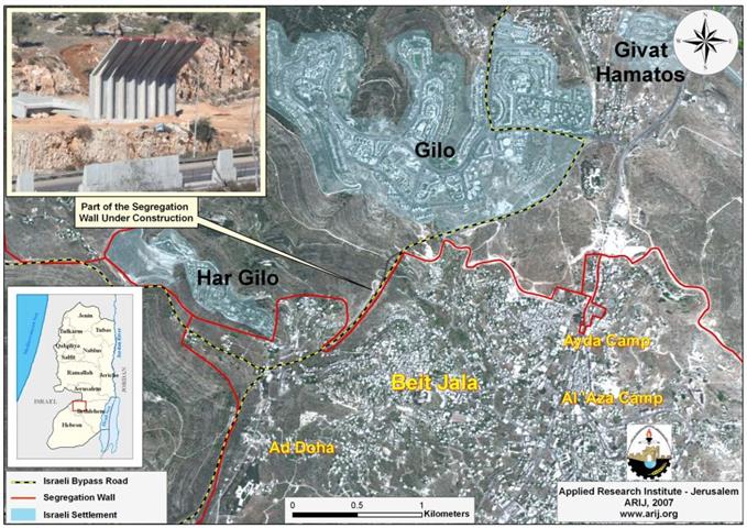
Wall Constructions recommence in Beit Jala City
An Israeli Bulldozer backed by Israeli Border Police commenced the construction of additional section of the...

Subterranean Wells of Jayyus and Beit Amin villages in Qalqiliya governorate-swamped with waste dumped by Israeli settlers
A repository of the trash where Israeli settlers get rid of their garbage is arousing peoples'...
Subterranean Wells of Jayyus and Beit Amin villages in Qalqiliya governorate-swamped with waste dumped by Israeli settlers
A repository of the trash where Israeli settlers get rid of their garbage is arousing peoples'...
Israeli commences the construction of the Segregation Wall north of Beit Jala City
The Israeli occupation bulldozers commenced last month 2007 the construction of the Segregation Wall north of...
Israel to reroute the Segregation Wall around Modi’in Illit Settlements Bloc West of Ramallah Governorate
On February 1, 2007, the Israeli Prime Minister Ehud Olmert, has approved a plan to reroute...
LATEST NEWS

ملاخي هشالوم: أكثر من مجرد بؤرة استيطانية … مشروع تهويد وتوسّع اسرائيلي
........................................................

العدالة المؤجلة ورأي بلا تنفيذ: من قرار المحكمة إلى واقع الضم
........................................................

Striking Wave of Escalating Settler Attacks and Forced Displacement in the Palestinian Jordan Valley
........................................................

تصاعد اعتداءات المستوطنين وعمليات التهجير القسري في الأغوار الفلسطينية
........................................................
