
Background
Beit Iksa is a Palestinian village located 9 kilometers northwest of the city of Jerusalem and about 0.5 Kilometer form the Armistice Line of 1949 (Green Line). The village is surrounded by the Segregation Wall, as well as the Illegal Israeli Settlements of Neve Samuel from the north, An Nabi Samuel village from its northeast, The Illegal Israeli settlement of Ramot from the west, the Palestinian village of Beit Surik from the east, and the Segregation Wall along with the Armistice Line of 1949(the Green Line) from the South.
The geographical area of Beit Iksa occupies a total area of 7734 dunums. According to the Oslo II Interim Agreement that was signed in 1995 between the Palestinian Liberation Organization and Israel, the lands of Beit Iksa Village were classified to area ‘B’ (591 dunums – 7.6 % of the village total area) where most of the built up area is concentrated and the rest went under area ‘C’ classification (7143 dunums – 92.4% of the total village area); where the lands in this area consists all the agricultural lands, as well as the forests and the open spaces that belong to the village. Its worth noting out that none of the village area was classified ‘A’.
1. Area ‘A’ Palestinian enjoy full control of the land and security
2. Area ‘B’ Palestinian has control of civil life issues but security and land administration remains under Israeli control
3. Area ‘C’ Israelis enjoy absolute control.
It is worth mentioning that the village of Beit Iksa was first targeted by the settlement program in 1973, when the village lost 1347 dunums (1.347 km² – 17.5%) of its lands for the construction of the Illegal Israeli settlement of Ramot, which accommodates today approximately 40000 Illegal Israeli settlers. Table 1 below shows the Land Use Land Cover of Beit Iksa village:
|
Land use Land cover of Beit Iksa Village Boundary
|
Area in Dunums
|
|
Agrilcultural Lands
|
2822
|
|
Forests & Open Spaces
|
3185
|
|
Palestinian built-up area
|
252
|
|
Israeli Settlement
|
1349
|
|
Wall Zone
|
126
|
|
Total
|
7734
|
|
Source: ARIJ Database 2009
|
|
The Israeli Apartheid Wall in Beit Iksa
According to the earlier revised maps of the Segregation Wall of June 30, 2004 and February 20, 2005, the lands of Beit Iksa village were included in the area trapped between the Israeli Segregation Wall (inside Jerusalem city) and the 1949 Armistice Line (the Green Line). A total of 7244 dunums of lands, 93.7% of the village’s total land area were about to become isolated inside the wall enclave which runs 190 km around Jerusalem city and will include 3 settlement blocs of Giv’at Ze’ev settlement bloc, Gush Etzion settlement bloc, and the Ma’ale Adumim settlement bloc, separating it from its natural environment; the nearby Palestinian communities located to the east, such as, Beit Surik, Biddu, Qatannah, Beit ‘Anan and Beit Duqqu.
According to the (April 30, 2006) Israeli route of the Segregation Wall which was published on the website of the Israeli Ministry of Defense, the update Wall plan in Beit Iksa village was set to put the village of Beit Iksa outside the wall enclave to the northwest, (the village would be removed from Jerusalem enclave and a fence would be constructed between the village and the settlement of Ramot Allon) mostly for security reasons. Despite the change, the village still loses much of its lands for the construction of the Segregation Wall where about 60% of its lands will still be isolated behind the wall (inside Jerusalem). See Map 1
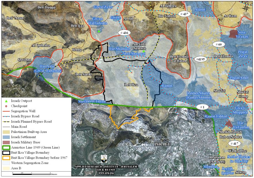
Map 1: The path of the Israeli Segregation Wall in Beit Iksa village in 2005
Later on, and in April 2007, the Israeli Ministry of Defense and on its website had published a revised route for the Israeli Segregation Wall, in which the built-up area of Beit Iksa village (252 dunums) became on the eastern side of the Wall while the agriculture lands as well as the rest of the lands of the village (4601dunums) became in the Western Segregation Zone (the area between the Segregation Wall path and the Green Line – Armistice Line of 1949).
It is worth mentioning that the Israeli Defense Ministry and after few weeks from April 2007 had retracted the revised aforementioned map of the Segregation Wall and reposted the April 30, 2006 map, however, on 29/7/2009 , the Israeli daily newspaper “Haaretz” had revealed that the Israeli Defense Ministry had adopted the plan of April 2007, in which Beit Iksa village will had became in the eastern side of the Wall while the agriculture lands as well as the rest of the lands of the village would set in the Western Segregation Zone (the area between the Segregation Wall path and the Green Line – Armistice Line of 1949). See Map 2
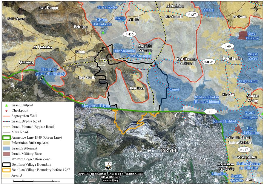
Map 2: The path of the Israeli Segregation Wall in Beit Iksa village in 2007
To Conclude
Israel continues with the construction of the Apartheid Segregation Wall in the occupied Palestinian territory, violating the Palestinians’ civil rights for freedom of movement, freedom of religion and proper health services and education, right to work, and also the right of live adequately in their houses and areas of their choice without restrictions, all of which guaranteed by the International law rules and human rights conventions.
The ICJ Advisory Opinion on the Legal Consequences of the Construction of a Wall in the Occupied Palestinian Territory in July 9, 2004.
‘The Court has reached the conclusion that the construction of the wall by Israel, the occupying power, in the Occupied Palestinian Territory including in and around East Jerusalem and its associated régime, is contrary to international law and has stated the legal consequences that are to be drawn from that illegality”.
Also “Israel is under an obligation to make reparation for all damage caused by the construction of the wall in the Occupied Palestinian Territory, including in and around East Jerusalem.”
“All States are under an obligation not to recognize the illegal situation resulting from the construction of the wall and not to render aid or assistance in maintaining the situation created by such construction; all States parties to the Fourth Geneva Convention relative to the Protection of Civilian Persons in Time of War of 12 August 1949 have in addition the obligation, while respecting the United Nations Charter and international law, to ensure compliance by Israel with international humanitarian law as embodied in that Convention.”
Also the construction of the Israeli Apartheid Segregation Wall clearly violates:-
-
Hague Convention IV (18 October 1907): Convention Respecting the Laws and Customs of War on Land: Article (23):‘To destroy or seize the enemy’s property, unless such destruction or seizure be imperatively demanded by the necessities of war”.
-
Convention (IV) relative to the Protection of Civilian Persons in Time of War. Geneva, 12 August 1949, Article 53: “Any destruction by the Occupying Power of real or personal property belonging individually or collectively to private persons, or to the State, or to other public authorities, or to social or cooperative organizations, is prohibited, except where such destruction is rendered necessary by military operations.”
Prepared by
The Applied Reserach Institute – Jerusalem
The Applied Reserach Institute – Jerusalem


