The Applied Research Institute – Jerusalem (ARIJ)
In cooperation with Palestine Economic Policy Research Institute (MAS)

Preface
Legalizing nine Israeli settlement outposts in the occupied West Bank
Over and over again, Israel continues to manipulate the status of the settlements and outposts in the occupied West Bank, with the aim to create ambiguity and confusion about what is legal and what is illegal, while the fact is that all Israeli settlements and outposts in the occupied West Bank are undoubtedly illegal, since they were forcibly built on lands belonging to Palestinians and without their consent; as the issue of resolving the conflict in a just and peaceful way becomes impossible.
In apathy to the international law, the Fourth Geneva Convention of 1949, and the signed agreements, the consecutive Israeli governments continue with their settlement activities in the West bank and the Gaza Strip to the fullest, which reflects the extent to which Israel is committed to its expansionist settlement plans in the occupied Palestinian territory. This in turn has led to irreversible facts on the ground, to impose its vision of resolving the conflict with the Palestinians, which eliminates any hope of establishing an independent, viable Palestinian state on the 1967 borders.
On the 12 of February 2023, the so-called “Israeli cabinet” in the Israeli government unanimously approved the legalization of nine Israeli settlement outposts illegally and unilaterally established in the occupied West Bank during the past few years. The Israeli outposts targeted in the latest approval process are: Avigail and Asael outposts established on lands of Hebron Governorate; Beit Hajla (Beit Hogla) outpost established on lands of Jericho Governorate; Givat Harel and Malachi Hashalom outposts established on lands of Ramallah Governorate; Givat Arnon outpost established on lands of Nablus Governorate; Mitzpe Yehuda outpost established on lands of Jerusalem governorate; Sde Boaz outpost established on lands of Bethlehem governorate, and Shaharet outpost established on lands of Salfit governorate.
This paper has been prepared by the joint efforts of the Applied Research Institute – Jerusalem (ARIJ) Institute and the Palestine Economic Policy Research Institute (MAS), to draw the attention, and increase knowledge among the Palestinian public and decision-makers, about the dangers Israeli settlement outpost pose, not only on the possibility of establishing an independent and viable Palestinian state, which is confirmed and documented; but also on the Palestinian economy, natural resources, environment, and the costs that the Palestinian people incur every day, as a result of the 56 years of the Israeli occupation.
In light of this planned and programmed settlement expansion policy, which is implemented by an Israeli system armed with colonial methodologies and mechanisms; there is no Palestinian or international official or civil body any longer that can take the responsibility of monitoring and analyzing this process, which constitutes the beating heart of the Zionist project; except for what ARIJ institute and some official and Palestinian Research organizations are doing, with little resources at the level of the challenge, in addition to some international efforts in the field of estimating the cost of the Israeli occupation.
ARIJ and MAS emphasize the urgent need for official, civil, and international bodies/organizations to take significant action in bolstering Palestinian capabilities to effectively address this critical conflict, an aspect of which this paper highlights, and which can serve as a common ground for joint collaboration between all concerned parties.
This report primarily utilizes databases available at ARIJ concerning Israeli settlements, as well as high-resolution aerial photos from 1997 to the present day. These resources enable us to track the evolution and growth of settlement outposts over time, in addition to incorporating data from several Palestinian research and human rights organizations, as well as relevant international and Israeli sources referenced throughout this report.
Israeli Settlement Expansion throughout the years of the Israeli occupation
Since Israel’s occupation of the Palestinian territory in 1967, Israeli governments have allocated significant resources to create and expand Israeli settlements in the occupied Palestinian territory, both in terms of area confiscated from the Palestinians and population. In 1991, the Israeli Civil Administration in the occupied West Bank issued master plans for Israeli settlements, including those in occupied East Jerusalem. These plans included future expansion areas for the existing Israeli settlements, and additional areas for the establishment of new settlements. The total area of Israeli settlements’ master plans issued by the Israeli Civil Administration at that time was 486 km² (8.6% of the area of the West Bank); which is seven times larger than the area of the Israeli settlements that existed until 1991, covering only 69 km² (1.2% of the West Bank’s area).
After the signing of the Oslo Accords I and II in 1993 and 1995 respectively, and the classification of Palestinian lands into “A”, “B”, and “C” areas, the Israeli occupation authorities ignored issuing master plans for Palestinian communities in area “C” to meet their urban needs and accommodate population growth, as they did for Israeli settlements. Palestinian communities remained at risk of demolition as they were unable to obtain the necessary permits from the Israeli civil administration[1], the main arm of the Israeli occupation in the occupied West Bank, which prevent the demolition of their homes/structures and consequently their displacement due to the imposition of harsh measures by the Israeli occupation Authorities on Palestinians acquiring building permits, and the lengthy and complicated procedures that Palestinians have to go through to get a building permit that enables them to build on their land or exploit it for any purpose whatsoever. Most of the Palestinians’ building requests were rejected by the Israeli occupation Authorities under the pretext of “not meeting the necessary conditions needed for building in area “C”.
The Israeli settlements jurisdiction area in the occupied West Bank exceeds that of the Israeli settlements master plan issued in 1991. This increase was as a result of Israeli military orders that have been issued and ratified during the years of the Israeli occupation, which granted Israeli settlements’ councils in the West Bank control over more Palestinian land for settlement expansion, in addition to the area which is already occupied by existing Israeli settlements. In addition to the several Israeli military orders, that have not been made public by the Israeli occupation authorities, to confiscate more Palestinian land for security purposes and other flimsy pretexts. These orders increased the Israeli settlements jurisdiction area to 542 km² (9.6% of the West Bank area), an increase of 56 km² of the Israeli settlements’ master plan area of 1991 (486 km²).
When Israel occupied the West Bank in 1967, only one third of the occupied West Bank territory was registered to the people with a Turkish (Ottoman Empire) issued Tabo (certificate of ownership) and/ or with an official British certificate/ registration issued during the British Mandate era. Fundamentally, the Ottoman land code (law) of 1858 continue to govern the land holdings in the West Bank but was never so used during the centuries of Ottoman rule, or under the British and Jordanian rules who maintained the same law. Israeli Military Order #59 (1967(amended by M.O.1091)), which constituted an abuse of the Ottoman land law, by which the Israeli Military-appointed position of ‘Custodian of Government Property’ expropriated land owned by the Jordanian Government. Also, allows the ‘Custodian of Government Property’ to expropriate land from individuals or groups by declaring it ‘Public Land’ or ‘State Land’, the latter which it defines as land that was owned or managed by, or had a partner who was an enemy body or citizen of an enemy country during the 1967 war.
Accordingly, when Israel occupied the West Bank territory it assumed control of what was assigned as State Land at the time – during the Jordanian rule. An area of 634,920 dunums (11.2% of the total West Bank area) was classified as “Registered State Lands”, where Israel considers itself the owner of these lands and the inheritor of the Jordanian rule that ended with the Israeli military occupation of the Palestinian territory in 1967, according to the Israeli interpretation of the law. Israel also proceeded to classify additional Palestinian lands as “State Land”, 843,922 dunums of land, 14.9% from the total West Bank area), mainly after 1979.
Currently, the ICA prepares to complete procedures on what is called “Surveyed State Lands” which constitutes 11.7% of the West Bank, with a total area of 666,327 dunums. In compilation, the total area of what is classified as “State Land” according to Israel rounds up to 2,145,169 dunums; some 38% of the West Bank total area).
- From outposts to urban blocks
The phenomenon of unauthorized settlement outposts began to spread in the 1990s, after the Rabin administration at that time reduced the rate of approval for building in Israeli settlements established in the West Bank and Gaza Strip in 1993[2], in order to accelerate negotiations with the Palestinians that preceded the signing of the Oslo Accords.
A “settlement outpost” is a “settlement bloc” built in the West Bank without an official decision or approval from the Israeli government. No land has been allocated for these communities, neither municipal boundaries have been set/defined for them, and their residents have not been granted any permission to use the land, whether for construction or agriculture. An Israeli settlement outpost usually takes the form of a new building or a number of caravans/structures (mobile homes) with limited area and separated from the urban area of a mother settlement. The settlement outpost is linked to a mother settlement by a dirt road, and it is constructed with the aim of expanding an existing settlement in the future, or as a ground for the establishment of a new settlement in the area.
This activity usually begins by one or more Israeli settlers seizing Palestinian hilltops adjacent to an existing Israeli settlement (1 mile to 4 miles away) known as the ”mother settlement”. The outpost often consists of only a few caravans and sometime a single tent where young Israeli-Jewish settlers take possession of land by means of forcing realities on the ground and naturally under the protection and the covert assistance of the Israeli occupation Army.
Despite the illegality of settlement outposts under international and Israeli law, the Israeli government has implicitly supported their maintenance and attempted to legitimize them or integrate them into existing settlements[3]. Israel has also ordered the army to provide security protection for these outposts, paved roads leading to them, and established infrastructure for water and electricity networks for most of them. Israel also provided support to settlement outposts through the various government ministries, settlement regional councils in the West Bank, and the Settlement Division, who provided financial support to settlement outposts, including agricultural facilities, and provided support for new settler farmers and cattle breeders, in addition to legal protection for settlement outposts under risk of removal and demolition.
The Israeli outposts Phenomena increasingly intensified after 1998 following the call of Ariel Sharon, who was serving as Minister of Energy and Infrastructure in the Netanyahu government at the time, to urge Israeli settlers to take as much Palestinian land as possible before “losing them to Palestinians in negotiations”. “Everybody has to move, run and grab as many hilltops as they can to enlarge the settlements because everything we take now will stay ours …everything we don’t grab will go to them.” Ariel Sharon addressing a meeting of militants from the extreme rightwing Tsomet party, Agence France Presse, November 15, 1998. [4] This was to prevent it from being handed over to the Palestinians later in the framework of any future peace between the two sides, the Israeli and the Palestinians. This call/statement was the green light for the establishment of the Israeli settlers group, “the Hilltop Youth Organization”, which plays the greatest role in controlling Palestinian land and establishing outposts today in the occupied West Bank, and they are the owners of the “Herding Outposts” Phenomena in particular.
Establishing and financing Israeli settlement outposts
The process of establishing most of the settlement outposts goes through several phases, all of which aim primarily at controlling Palestinian land. All Israeli governmental and non-governmental bodies related to settlement construction in the West Bank take part in these phases, which are summarized as follows[5]
The first step: establishing a new outpost
This is done by creating facts on the ground either at the hands of Israeli settlers or the Hilltop Youth settler group, through constructing a new road and erecting a number of tents or placing mobile homes (caravans). This is followed by a protocol process that involves issuing demolition orders by the inspection unit of the Israeli Civil Administration; however, this is being countered by the Amana leaders, Yesha Council officials, rabbis and Knesset members who exercise pressure on the Israeli government and the Israeli Civil Administration to refrain from the implementation of the orders and the eviction/removal of the outposts.
The second step: gaining rights of land
The Settlement Division is responsible for developing Israeli settlements in what is known as Judea and Samaria (the West Bank). Its powers include managing the land entrusted to it by the World Zionist Organization, which the Israeli civil administration has allocated more than 450,000 dunums (35%) of the West Bank’s area as state land (registered and declared) in “Area C.” The Settlement Division signs contracts with Israeli settlers for construction or use of land allocated to them, known as bar Reshut or authorization certificate[6], without government supervision or approval from relevant authorities such as the Israeli land administration. Moreover, the Custodian of abandoned property does not bother to receive payments for the use of the land.
Third step: Preparation and Approval of plans
The cost of preparing and reviewing building plans throughout the approval process may reach hundreds of thousands of shekels. Most construction plans in the occupied Palestinian territory are initiated by settlement regional councils, Amana settlement movement or the settlement Division. It is not always possible to know the source of funding for these plans. However, there are documented cases where funding came from settlement regional councils, as listed in the non-recurring expenditure (NRE) for the Binyamin Regional Council, which was made public following a petition filed by the Peace Now movement, as the council approved around 33 million new Israeli shekels for various planning projects between 2000 and 2014. Among these projects also, illegal planning projects for residential or public buildings in illegal settlements and settlement outposts in the West Bank, such as, under the “Settlement Urban Planning Scheme”, which appears to be a code name for illegal settlement outposts, the Benyamin regional council approved in November 2014, a budget of 150,000 shekels to plan for daycare centers in five illegal settlement outposts.
In other funding cases, and following a request submitted by the ‘Peace Now’ movement under the Freedom of Information Act, the Israeli Ministry of Housing and construction provided a list of all its investments in settlements; among other issues, it became apparent that the Israeli ministry of housing and construction had approved funding for plans in illegal settlement outposts where illegal construction had already taken place, such as Za’it Ra’anan, Nahliel Tal (Karm Re’im), Brosh (Betronot), Giv’at Salit, Mitzpe Danny, Bnei Adam, and Ibi Hanhal outposts.
It also appeared in the Israeli settlement division’s exemption of the tender document as of 2 July, 2012, that the settlement division seeks to pay the salaries of an architect to prepare a plan for the Giv’at Salit outpost (62,000 shekels in addition to the 52,000 shekels already paid to him). It should be noted that designing a “city planning scheme” itself is not an illegal act, which is a prerequisite for legal construction; however, these plans are often used for construction without obtaining the necessary legal approvals, and construction often continues even in the absence of valid certificates or documents.
Fourth step: issuance of building permits
The Israeli settlement regional councils issue fake building permits under various names or justifications, through which infrastructure is provided for the outpost and real estate loans are obtained, in complete absence of law enforcement authorities to hold those responsible accountable for any illegal activity related to this stage.
Fifth step: Establishing infrastructure
The regional councils refer to illegal outposts as normal settlements in every sense, as evident from the list of settlements on their internet websites. The settlement regional councils illegally fund the settlement outposts and transfer money for their construction and management, while attempting to conceal the real goals behind these funds. In addition to the settlement regional councils, the settlement division and the Amana settlement movement are also partners in this funding, which is used entirely or partially to finance the construction of roads, water and sewage networks for the outposts and to connect them to the electricity grid.
Step Six: Building homes and selling them to Israeli settlers
Amana website contains information about the projects and apartments (settlement units) it offers as the “Amana Settlements” list (published on their website) includes the following settlement outposts: Avigail, Ahiya, El Matan, Esh Kodesh, Givat Harel, Harisha, Mev’ot Yericho, Mitzpe Danny, Mitzpe Hagit, Mitzpe Yair, Mitzpeh Asayel, Neve Erez, Adi Ad, Einot Kedem, Amona, Beni Kedem, Keda, and Shvut Rachel. It is worth mentioning that tracing the funding for construction in Israeli settlement outposts is more difficult than in settlements themselves; However, in one of the email letters Peace Now received from the Amana Information Center, it appeared that, “These settlements undergoing projects by Amana, including the “Rechalim” and “Hayovel” outposts. This indicates the role played by the Amana settlement movement in funding construction in settlement outposts, and highlights the role it plays in marketing the apartments built in the outposts through various means, including advertising on internet websites.
Step 7: Daily maintenance and upgrading of the outposts
The regional councils, the Amana settlement movement, and the settlement division maintain and develop illegal settlement outposts, and continue to finance and manage them on a daily bases following the completion of their construction; as the Settlement Regional councils build and operate kindergartens, maintain electrical systems and infrastructure, as well as handle transportation, waste collection and sewage services; while the Israeli regional councils along with the Israeli Settlement Division and Amana settlement movement fund the construction of public buildings and the development of public spaces in the settlement outposts.
Step 8: legalizing the Outposts in a retroactive manner
Since the emergence of the settlement outposts’ phenomena in 1996 (during Netanyahu’s first Government), all Israeli government have officially claimed to abandon these outposts, asserting that they are illegal and declared their intention to evacuate them; However, in reality, the successive Israeli governments allowed them to develop and grow and provided them with the necessary funding, through their various settlement arms, who also provided legal support to face the demolition and eviction orders issued against them. Moreover, the Israeli governments turn a blind eye to the daily settler attacks committed against Palestinians and their properties (by settlers residing in the outposts) , and even pass laws to legitimize them. On February 6, 2017, the Israeli Knesset passed the ” Regulation Law,” legalizing about 4,000 settlement units in 55 settlement outposts built on private Palestinian land[7]. As of 2019, 15 settlement outposts were retroactively legalized, while at least 35 other outposts are currently undergoing the approval process; four of which received an official government decision to classify them as new settlements, in addition to the new “Amihai” settlement, which the government established for settlers of the evacuated “Amona” outpost.
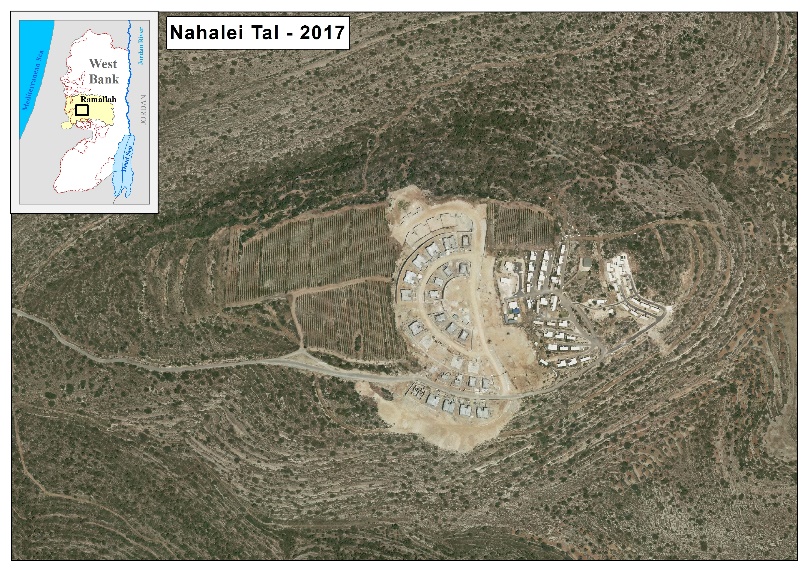
Settlement outposts have become a crucial bargaining chip in forming government coalitions, with the latest example being the inclusion of the Israeli Knesset member from the Jewish Power party (the Otzma Yehudit), Itamar Ben Gvir, in Benjamin Netanyahu’s government in November 2022 after agreeing on several issues, including a plan presented by Ben Gvir that involves seizing more Palestinian land in the West Bank to develop settlement outposts referred to, in the plan, as “youth settlements.” The plan also calls for legitimizing 60 settlement outposts in the West Bank 60 days after the formation of the government, and providing budgets and mechanisms to legalize all outposts in the West Bank within 18 months of the formation of the government, with the government allocating more than 200 million shekels annually to develop the infrastructure in these outposts to implement this plan. [8] One example of establishing and developing settlement outposts in the occupied West Bank is ‘Nahali Tal’ outpost (also known as ‘Kerem Reim’), which was illegally established on lands belonging to Al Mazra’a Al Qiblyia village in Ramallah Governorate. The settlers seized a hilltop in the village and established a vineyard farm. Later in 2009, the settlers placed their first mobile home (‘caravan’) in the area. Over time, many more mobile homes were added to the site until their number reached to 50 in the year 2015; followed by the construction of permanent homes and buildings in the outposts. The construction and expansion process in the outpost continues to this day.”
|
|
|
|
|
 |
 |
 |


No. of outposts and their classification
Since the outbreak of settlement outposts in the occupied West Bank, many sources have reported varying statistics on the number of settlement outposts, either due to differences in the definition of the settlement outposts from one source to another, or due to the Israeli restrictions imposed on accessing information on the Israeli side, or restrictions imposed on some scientific research tools such as high-resolution satellite images used to track the establishment and development of these urban areas. In this report, we will adopt a methodology based on setting a definition for the settlement outpost, which have been provided in the introduction of this report, and then analyzing high-resolution satellite images over different years according to what is available from sources, since 1997 to 2021, and verify the results through reports published by official sources or field visits.
According to the analysis of maps and available satellite images, there are 243 settlement outposts scattered throughout the West Bank territory and were established over the years, from mid-1990s to 2022, as shown in the table below:
|
No. of Israeli outposts |
Date of Establishment |
|
67 |
Until 1997 |
|
82 |
1998 – 2002 |
|
34 |
2003 – 2007 |
|
7 |
2008 – 2012 |
|
16 |
2013 – 2017 |
|
37 |
2018 – 2021 |
|
243 |
Total |
The peak spread of Israeli settlement outposts in the occupied West Bank was between 1998 and 2007, during which Israeli settlers established nearly 50% of the current number of settlement outposts in the occupied West Bank; the same period in which Ariel Sharon served as a Minister of Foreign Affairs (1998) in the Twenty-seventh government of Israel. These outposts spread across the West Bank Governorates without exception, with the largest number of outposts in Ramallah and Al Bireh, Hebron and Nablus Governorates respectively; which together host about 64% of the total number of settlement outposts in the occupied West Bank. The following chart shows the number of outposts in each Palestinian governorate:

There are 202 inhabited settlement outposts, representing approximately 83% of all settlement outposts in the occupied West Bank, including 81 settlement outposts that partially or wholly contain permanent buildings (residential homes or industrial facilities). This means that these 81 outposts have been transferred or are in the process of being transferred into neighborhoods belonging to existing settlements or independent settlements. In addition, there are 41 uninhabited settlement outposts, including 6 settlement outposts that have been evacuated at various times, such as the Amona settlement outpost, which was evacuated in 2017, and the Migron settlement outpost, which was evacuated in 2012.

Although some of the settlement outposts are uninhabited or evacuated, this does not change the fact that settlers control the land as soon as the outpost is established. Palestinian citizens remain prohibited from using or accessing the lands that have been seized for the establishment of the settlement outposts. Israel places these lands under the protection and control of the Israeli army, even if it is proven that these lands are private property of Palestinian citizens, as is the case of the evacuated “Migron” outpost in Ramallah Governorate.
Exploiting land classification in favor of Israeli outposts
Israel adopts a number of mechanisms to seize Palestinian land by relying on a combination of illegal military orders that legalize the control of land, and provide definitions for what is considered “public” and what is considered “private” in the occupied Palestinian territory. Israel even dedicates these definitions to legitimize Israeli settlement outposts in the occupied West Bank, through the control of land under various pretexts, most notably “state lands”, “settlement jurisdiction area”, and “lands designated for military purposes”.
Following its occupation of the Palestinian territory in 1967, the successive Israeli governments invested substantial resources in establishing new Israeli settlements in the occupied West Bank and expanding them throughout the years of the Israeli occupation, through the expropriation of Palestinian land under various pretext, including “Closed Military Area” – militray order 378- and the expropriation of land under the “Nature Reserve” pretext –militray order No. 363- and the Acquisition of land by Declaring ‘Expropriation for Public Services’ under Military Order 321; and the Confiscation of land under Military Order No. 59 of (1967)- ORDER CONCERNING STATE PROPERTY; and the Acquisition of land by Declaring ‘Abandoned Land’ – military order 58 – which defines absentee as someone who has left the area of the West Bank before, during or after the time of the 1967 war ; and the confiscation of land under militray order 271 of 1968, concerning occupied Land declared as ‘Combat or Fighting Zones’ and many other military orders that were issued during the years of the Israeli occupation and contributed significantly to the confiscation of Palestinian lands and subjecting them to Israeli control, and later exploited to expand Israeli settlements and other settlement activities in the occupied West Bank.
Land declared as “State Land”
“State Lands “are lands registered in the Land Registry Department as “government property” belonging to the Kingdom of Jordan before 1967; and lands that were declared by the Israeli military government, through Military Order No. 59/967, as “Public Lands”; meaning, they are not lands of private ownership, and the Israeli military administration is responsible for managing these lands’ that are supposed to be used for “public interest/purpose”. The area of the registered and declared “State Land” in “Area C” in the occupied West Bank stands at 1,286 km², constituting 37% of Area C; In violation of International occupation law, the Israeli military commander – through the Civil Administration – has allocated the overwhelming majority of public lands for the use of the Israeli settlement program in the occupied West Bank[9][10].
Lands classified as “Settlement Jurisdiction Area”
It is the border of a municipality area of a specific local authority that was defined by order of the military commander of the aewa (commander of the central region) in a move to consolidate the existence of Israeli settlements on the lands they occupied from the Palestinians[11]. In 1991, the Israeli civil administration (ICA) operating in the occupied West Bank (oWB) designated master plans for Israeli settlements spread throughout the oWB including those in occupied East Jerusalem; these plans allocated future expansion areas for the existing Israeli settlements and also included additional areas for the establishment of new settlements in the OWB in the future and the expansion of the existing ones (that were established up until 1991).
The area of the Israeli settlements master plans issued at that time stood at 486 km², and it is worth noting that the Israeli settlements jurisdiction area exceeds that of the master plans. This increase in area came through Israeli military orders that were issued and approved during the years of the Israeli occupation, which granted the settlements’ regional and local councils, to which these settlements are affiliated, control over additional areas of Palestinian land in addition to those occupied by the Israeli settlements urban area today. By the end of 2022, the land that falls within the Israeli settlements jurisdiction area stands at 542 km², 8.6% of the total WB area, which is seven times the size of Israeli settlements area existed until the year 1991 which stood at 69,000 dunums (69 km²; 1.2% of the total area of the WB; and 16% of the Area classified as “C” in the occupied West Bank, and often includes lands that Israel defines/classifies as “state lands”.
Land designated for military purposes
Under international and humanitarian laws, Israel is obligated to protect the property of citizens residing in the occupied territory and prevent its confiscation. However, Israel may temporarily seize privately owned lands and buildings of citizens in the occupied area to house its military forces and administrative units. This seizure is by definition “temporary,”; accordingly, the occupying power does not acquire ownership rights over the seized lands and buildings, nor does it have the right to sell them to others. In addition, the occupying power is obligated to pay compensation to owners for the use of their property; however, Israel allows settlers to convert unused military sites into settlement outposts, as happened in a military site adjacent to “Massu’a” settlement in the Jordan Valley, where 12 settler families established a settlement outpost in the site and named it “Gadi Camp”. In other cases, the Israeli occupation army declared the locations of the evacuated settlement outposts as “closed military zones” and prevented Palestinian landowners from using or accessing them.
Israeli Settlement outposts are established on lands regardless of their classification or ownership, as long as the goal is to control the land, deprive Palestinians citizens of their lands, expand the geographical area of the settlements, and link Israeli settlements with each other. In this regard, 131 settlement outposts have been established on lands that have been classified by the Israeli occupation authorities as “state land”, including 93 settlement outposts that have been established on lands classified as “Settlement Jurisdiction Area”. The settlers also established 20 other outposts on lands classified as “Settlement Jurisdiction Area”, and 19 others on lands falling within the “settlement master plan” classification. The remaining 73 settlement outposts have been established on lands that do not fall under any of the aforementioned classifications or definitions, including 54 settlement outposts that have been established on lands that Israel acknowledges as “privately owned by Palestinians”.
|
No. of Israeli outposts |
Land Classification |
|
* 131 |
State Land |
|
20 |
Settlement Jurisdiction Area |
|
19 |
Master Plan (Israeli settlement) |
|
73 |
Other (Private Palestinian Property) |
|
243 |
Total |
|
* Including 93 settlement outposts on lands also classified as settlement Jurisdiction area |
|
Taking Control of “Private Land” in the West Bank
The process of land registration in the West Bank began during the Ottoman rule, and continued during the British Mandate and under the Jordanian rule. Shortly after the Israeli occupation of the Palestinian Territory (the West Bank including East Jerusalem and the Gaza Strip) in 1967, Israel froze land registration procedures. Until then, only 30% of lands of the West Bank had been registered. This means that there are two types of private land: (1) private land that has been settled – meaning land that has been registered in the names of its Palestinian landowners in the Land Registry Department run by the Israeli army in the occupied Palestinian territory; and private land that has not been settled – that is, private land in Palestinian possession and cultivated by Palestinians, but its ownership is not registered in the land registry[12]. A report commissioned by the Israeli government in 2010, written by the head of image analysis department at the Israeli Mapping Center, stated that 60% of the land controlled by outposts was land that Palestinians had previously cultivating, making it, according to the “law” applicable in the West Bank, private land[13].
Among 54 settlement outposts built on lands that Israel acknowledges as “privately owned by Palestinians”, around 40 settlement outposts are referred to as “farms/herding outpost,” that is, rely on grazing sheep, goats, and cattle over vast areas of land. Compared to building in settlements, starting a farm or a herding outpost requires far fewer resources, making it easier for settlers to seize vast areas of land that extend over thousands of dunums adjacent to the outpost, and usually include pastures, water sources, and lands that Palestinians cultivate [14].
Other Forms of settlement construction
Land takeover in the occupied West Bank is not limited to military sites, settlements, or outposts. It includes the establishment of related structures necessary for the development and sustainability of these settlements. These structures include, but are not limited to, water reservoirs, water pumping stations, wastewater treatment plants, mobile phone booster towers and networks, and solar energy production fields. Over 47 locations, that are remote from settlements urban centers in the occupied West Bank, have been seized, which makes these settlements and outposts centers for investment and development, particularly in the fields of agriculture and energy.
|
No. of sites |
Use of land |
|
11 |
water reservoir |
|
18 |
Water Pumping Station |
|
6 |
Wastewater Treatment Plant |
|
9 |
Telecommunication Tower |
|
3 |
Solar Panel Production Field |
 Map 1: The Distribution of Israeli settlement outposts in the occupied West Bank
 Map 2: Registered and Declared State Land in the occupied West Bank according to the Israeli classification
 Map 3: The distribution of Israeli settlement outposts with regard to Land classification
The legalization of nine Israeli settlement outposts in the occupied West Bank
The following are details of the settlement outposts that have been legalized by the Israeli government:
- Avigail settlement outpost: it was illegally established in 2002, on lands of At Tuwani village in the southern Hebron governorate in the occupied West Bank. The outpost was erected on lands that were classified by the Israeli occupation authorities as “firing zone” by virtue of several Israeli militray orders issued following the Israeli occupation of the Palestinian territory in 1967, including Israeli Military Order No. 60, Israeli Military Order No. 61, Israeli Military Order No. 62, Israeli Military Order No. 63, Israeli Military Order No. 64 and several other related orders. Today, the settlement outpost occupies an area of 110 dunums of Palestinian land, and it comprises 74 units/caravans/barracks. The outpost is located southwest of Maon settlement, in the southern Hebron Governorate.
 Photo 1: The Israeli settlement outpost – Avigail (2002-2021)
- The settlement outpost known as “Beit Hajla” or “Beit Hogla” was illegally established in 2002 on lands of Deir Hajla village in Jericho governorate, in the occupied West Bank. The settlement outpost was built on Palestinian land classified by the Israeli occupation authorities as “state lands”, by virtue of Israeli Military Order No. 59 and “Israeli settlements jurisdiction area”. The settlement outpost currently has 40 units/caravans that have been erected in the settlement outpost since its establishment, and it occupies 48 dunums of Palestinian lands, along the Israeli bypass road No. 90.
 Photo 2: Beit Hagla or Beit Hogla settlement outpost, (2001-2021)
- Givat Harel settlement outpost: It was illegally established on lands of Sinjil village in Ramallah governorate in the occupied West Bank, on Palestinian lands that are classified by the Israeli occupation Authorities as “Unregistered State Land”. The settlement outpost currently has 120 units/caravans facilities, including residential barracks and other facilities. It is situated in close proximity of “Eli” settlement (illegally established in 1984), to its northeastern side. The Givat Harel settlement outpost currently occupies 350 dunums of Palestinian land.
 Photo 3: Giv’at Harel settlement outpost – (1999-2021)
- Givat Arnon Settlement Outpost: It was illegally established in 2001 on lands belonging to Einun village in Nablus Governorate in the northern West Bank. The Israeli Occupation Authorities classify the lands on which the outpost was erected as “State Land”. The outpost currently consists of 55 units/caravans and occupies a total land area of 350 dunums of Palestinian lands. The outpost is situated to the southwest of Itamar settlement (illegally established in 1984) in Nablus Governorate.
 Photo 4: Givat Arnon settlement outpost 2003-2021
- Mitzpe Yehuda settlement outpost: It was illegally established in 2019 on lands belonging to Al-Sawahra town in occupied Jerusalem, to the southwest of Kedar settlement (established in 1984). The Israeli occupation authorities classify the lands on which the outpost was established as “State Lands.” Today, the outpost is home to 10 caravans/mobile homes, and occupies 17-dunums of land in the area.
Mitzpe Yehuda settlement outpost is located in the Israeli so-called “Ma’ale Adumim” settlement bloc, which is the largest settlement bloc in the occupied West Bank in terms of area. The Israeli occupation authorities seek to annex this settlement bloc along with four others in the occupied West Bank (Ariel settlement bloc, Modi’in Illit bloc, Givat Ze’ev bloc and Gush Etzion bloc) to the new borders Israel is illegally and unilaterally redrawing by the construction of the Israeli Segregation Wall in the occupied West Bank. Concurrently, the Israeli occupation authorities continue to displace Palestinian Bedouin communities residing in the area (approximately 4,000 Palestinians in the Ma’ale Adumim settlement bloc) by targeting their homes and structures with demolitions, with the aim of seizing the entire area.
 Photo 5: Mitzpe Yehuda settlement outpost (2017-2021)
- Malachi Hashalom Outpost: It was illegally established in 2001 on lands belonging to Al-Mughayyir village in the Ramallah governorate in the occupied West Bank, to its northeast. The Israeli occupation authorities classified the lands on which the settlement outpost was established as “Unregistered State Land.” Since its establishment, 27 units or caravans have been erected in the outpost, which currently occupies an area of 130 dunums.
 Photo 6: The Malachi Hashalom Settlement outpost (2014-2021)
- Asael settlement outpost: It was illegally established in 2002 on lands belonging to As-Samu’ town in Hebron Governorate, located in the southern part of the occupied West Bank, and along the Israeli bypass Road No. 317. The land on which the Asael outpost stands is classified as “State Land” by Israel. Currently, the outpost comprises 81 units/caravans and occupies an area of 61 dunums of Palestinian land.
 Photo 7: The Asael settlement outpost (2002-2021)
- Sde Boaz settlement outpost: It was illegally established in 2003 on Palestinian land that belong to Al-Khader town in Bethlehem governorate. The outpost’s name derives from its proximity to the “Neve Daniel” settlement located to the north, within the Israeli so-called “Gush Etzion” settlement bloc.
The “North Neve Daniel” or “Sde Boaz” settlement outpost was established by an Israeli settler who previously resided in the “Neve Daniel” settlement. The settler occupied a Palestinian hilltop 1,500 meters north of Neve Daniel (the mother settlement) and placed a residential caravan (mobile home) in the area, later fencing it off. The settler received protection and assistance from the Israeli occupation army, which encouraged other settlers to join and live in the outpost. Since its establishment, the outpost has undergone several expansion activities and now encompasses 54 caravans and occupies 52 dunums of Al-Khader Town’s lands. Despite its illegality, the settlers who live in the outpost enjoy basic services and infrastructure, such as water, electricity, and telephone networks.
 Photo 8: Sde Boaz settlement outpost (2003-2021)
- Shaharit settlement outpost : it was illegally established in 2017 on Palestinian lands that belong to Kafr al-Dik village in Salfit governorate, located in the northern occupied West Bank. The land was classified by Israel as “State Land”. The Shaharit settlement outpost is located northwest of Bruchin settlement, which was established in 1999. Currently, there are six units/caravans in the outpost, and it occupies an area of 30 dunums.
On November 22, 2022, the “Custodian of Absentee Property” in the occupied West Bank issued a military order to seize 360 dunums of land in Salfit governorate, in the northern occupied West Bank, under the pretext that the lands were classified as “absentee property. According to sources, the “Custodian of Absentee Property” plans to grant planning permission for the targeted lands. The affected areas include Palestinian lands belonging to the villages of Bidya and Kafr al-Dik in Salfit Governorate. The order stipulates that the planning permission will take effect within 30 days of its publication date.
 Photo 9: Shaharit settlement outpost (2015-2021)
- [1] In 1981, the Israeli cabinet established the “Israeli Civil Administration”- (ICA), as a governing body over the territory it occupied during the 1967 war in order to manage civilian activities on its behalf, in order to carry out bureaucratic functions such as planning, transportation, health, education, etc.
- [2] Retrieved from Summary of the Opinion Concerning Unauthorized Outposts-Talya Sason, Adv., 2005 https://www.mfa.gov.il/mfa/aboutisrael/state/law/pages/summary%20of%20opinion%20concerning%20unauthorized%20outposts%20-%20talya%20sason%20adv.aspx
- [3] Retrieved from Settling Area C: The Jordan Valley Exposed, Mercedes Melon, Al-Haq 2018, page 14 https://www.alhaq.org/cached_uploads/download/alhaq_files/publications/SettlingAreaCTheJordanValleyExposed.pdf
- [4] https://books.google.ps/books?id=5KhXE6mqSx8C&pg=PA6&redir_esc=y#v=onepage&q&f=false
- [5] Retrieved from Unraveling the Mechanism behind Illegal Outposts, http://peacenow.org.il/wp-content/uploads/2017/03/unraveling-the-mechanism-behind-illegal-outpots-full-report-1.pdf
- [6] Retrieved from Preliminary Approval for Settlement Division Bill, https://peacenow.org.il/en/preliminary-approval-settlement-division-bill
- [7] Retrieved from Forced Population Transfer-The Case of Palestine Land Confiscation and Denial of Use, Lubnah Shomali and Amaya al-Orzza, BADIL Resource Center for Palestinian Residency and Refugee Rights 2017.
- [8] https://www.al-ayyam.ps/pdfs/2022/11/29/p01.pdf
- [9] https://www.yesh-din.org/en/glossary-terms-settlements-outposts-west-bank/
- [10] https://www.yesh-din.org/en/glossary-terms-settlements-outposts-west-bank/
- [11] https://www.yesh-din.org/en/glossary-terms-settlements-outposts-west-bank/
- [12] https://www.yesh-din.org/en/glossary-terms-settlements-outposts-west-bank/
- [13] https://www.yesh-din.org/en/turning-black-into-white/
- [14] Retrieved from State Business Israel’s misappropriation of land in the West Bank through settler violence, Page 8 https://www.btselem.org/sites/default/files/publications/202111_state_business_eng.pdf
Prepared by:
The Applied Research Institute – Jerusalem