• About The Project
  • Palestine in Century
  • Selected Maps
  • Glossary
  • About ARIJ
  • About LRC
  • By Year
    • Case Studies By Year
    • Daily Report By Year
Monday, May 12, 2025
POICA
No Result
View All Result
  • Home
  • Settlements
    • New Israeli Settlements
    • Settlement Expansion
  • Israeli Violations
    • Agriculture
    • Confiscation
    • Demolition
    • Environment
    • Eviction of Palestinians
    • Settlers Attacks
  • Bypass Roads
  • Israeli Plans
  • Segregation
    • Checkpoints
    • Closure
    • Separation Plans
  • Military Orders
  • Reports
    • Daily Report
    • Monthly Report
    • Quarterly Report
No Result
View All Result
POICA
No Result
View All Result

Revava colony expands on Haris Village lands / Salfit Governorate

November 7, 2022
in Settlement Expansion
Revava colony expands on Haris Village lands / Salfit Governorate


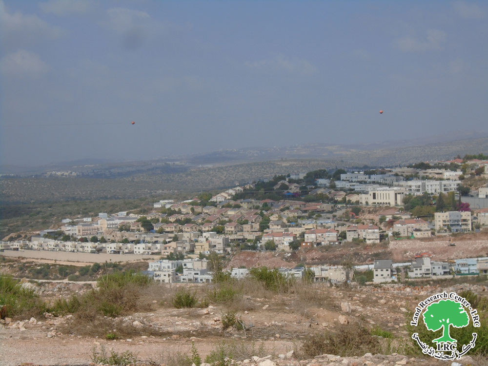
  • Violation: Establishing a new colonial block.
  • Location: Haris village west Salfit.
  • Date: October 2nd 2022.
  • Perpetrators: The High organization council at the Israeli Civil Administration.
  • Victims: People of Haris village.

Description:

The high organization council on the Israeli Civil Administration – Colonization subcommittee published signs in “At-Tayrat” area within natural block (8) of Haris village lands west Salfit , the signs include a plan that shows where the expansions will take place , in the area that connects the colony Revava , to Burkan , and Kryat Netavim , on lands that were registered as state lands , on an area of 265 of postures.

Last August, the Israeli Civil Administration and the high organization council at the Israeli Civil Administration deposited a new organizational plan (170/5) to expand control area that Revava colony covers. The order is a modification of the British Mandate plan that targets the location.

This will expand Revava colony double its current size , and turn it into one large cluster along with Ariel, Elkana , Burkan and Rivava colonies , this will devour large parts of the governorate lands .

The Occupation targeted a number of colonial plans in Rivava colony , LRC Israeli Violations team documented the plans and the targeted area:

The targeted location

date

Number of units

Plan no.

Plan status

notes

Natural blocks 2 , parts of locations: Al-Burj, and Khallet Haida from Haris lands

February 24th 2014

–          

No 170/5/2

Announcement of plan deposition

Announcement made by high organization council , colonization subcommittee and the aim is:1- changing land allocation from agricultural areas into area allocated for buildings ,  public facilities for the Ministry of education , working sports , open public areas and roads.

2- publishing construction instructions within the project borders.

Haris

August 16th 2016

17

170/4/5

Announcement of plan deposition

Anouncement made by: high organization council – Colonization subcommittee.

Deir Istiya

Natural blocks 8 and 2

January 23rd 2020

55

170/4/8

Announcement of plan deposition


Deir Istiya natural block 8

And Haris natural block 2


February  11th 2021


170/4/8

Announcement of plan deposition


Deir Istiya town natural block 8 , At-Tayrat klocation.

Haris village natural block (2) Al-Breig location

August 8th 2022

399

170/5

plan deposition


Revava settlement Expansion over the years

About Haris:  [1]

7 km to the northwest of Salfit governorate, Haris is located with a total land area of 8769 dunum, of which 190 dunums are the village’s built-up area. Haris is surrounded by the villages of Deir Istiya from the north, Kifl Haris from the east, Kfar ad-Dik and Bruqin from the southwest and Qarawat Bani Hassan from the west.

It has a total population of 3740 people according to the census of Palestinian Central Bureau of Statistics for 2009. Those people hail from the following families: Abu Atta, Dawoud, Salamih, Sultan, Shihada, Souf, Faz’, Awwad, Qasim, and Klaib. The Israeli occupation confiscated 3631 dunums from the village as follows: 

  1. Israeli colonies confiscated 2672 dunums as detailed in the below table

colony

Year of establishment

Confiscated area\dunum

Number of colonists

Kiryat Netafim

1982

188

384

Revava

1991

269

703

Burkan

1981

177

1207

Burkan Industrial

1981

1346

—

Ariel Industrial

—

692

—

Total


2672

2294

  1. 726 dunums were confiscated to open the bypass roads numbers ( 505, 4765, 5506)
  2. The apartheid wall confiscated 233 dunums for its establishment. Upon its completion, the wall will isolate 7135 dunums

According to Oslo Accords, the lands of Haris are classified as follows:

  • 631 dunums are classified as area “B”
  • 7815 dunums are classified as area “C”

About Revava colony:[2]

The colony of Revava started in 1991 on confiscated lands from Deir Istiya village. It totals 1540 dunums in area, of which 436 are the colony’s built up area. Revava has a total population of 703 .

The colony of Revava, since its establishment, formed an obstacle in the face of the Palestinian building movement in the area of Deir Istiya in addition to the confiscation of vast area of agricultural lands and the ban on sheep grazing in the periphery of Israeli colonies. 


[1] GIS-LRC

[2] GIS-LRC


Prepared by
 The Land Research Center
LRC

Recommended For You

إسرائيل تمضي قدمًا في مخطط استيطاني جديد على أراضي مدينة بيت جالا، في انتهاك للقانون الدولي وحرمان الفلسطينيين من أراضيهم

by arij
April 29, 2025
0
Israel Advances Settlement Plan on Ancient Olive Groves on lands of Beit Jala city, Violating International Law and depriving Palestinians their lands

  في أواخر شهر شباط من العام 2025، صادقت دولة الاحتلال الإسرائيلي على مخطط استيطاني جديدة لبناء حي سكني للمستوطنين على مساحة 22.2 دونما من الأراضي الفلسطينية لتابعة...

Read moreDetails

سلطات الاحتلال الإسرائيلي تصادر 64 دونما شمال مدينة بيت لحم لإقامة موقفا للحافلات

by arij
October 19, 2023
0
سلطات الاحتلال الإسرائيلي تصادر 64 دونما شمال مدينة بيت لحم لإقامة موقفا للحافلات

  في السابع من شهر أيلول من العام 2023, صادقت بلدية الاحتلال الإسرائيلي في القدس المحتلة على مخطط استيطاني جديد من شأنه أن يصادر مساحات شاسعة من أراضي...

Read moreDetails

Israeli Settlements in the Occupied West Bank: from “outposts” to urban blocks

by arij
May 20, 2023
0
Israeli Settlements in the Occupied West Bank: from “outposts” to urban blocks

  The Applied Research Institute – Jerusalem (ARIJ) In cooperation with Palestine Economic Policy Research Institute (MAS)   Preface Legalizing nine Israeli settlement outposts in the occupied West...

Read moreDetails

استكمال انشاء حي استعماري تابع لمستعمرة ” الكانا” على أراضي قرية مسحة / محافظة سلفيت

by arij
November 1, 2022
0
استكمال انشاء حي استعماري تابع لمستعمرة ” الكانا” على أراضي قرية مسحة / محافظة سلفيت

  الانتهاك: توسع استيطاني. الموقع: قرية مسحة / محافظة سلفيت. تاريخ الانتهاك: تشرين أول 2022. الجهة المعتدية: مستعمرة " الكانا". الجهة المتضررة: أهالي قرية مسحة.  تفاضيل الانتهاك:   استكمل...

Read moreDetails

بواقع “4,762 دونما”, سلطات الاحتلال تصادق على عددا من المخططات الاستيطانية منذ بداية شهر تشرين أول 2022

by arij
October 19, 2023
0
بواقع “4,762 دونما”, سلطات الاحتلال تصادق على عددا من المخططات الاستيطانية منذ بداية شهر تشرين أول 2022

  كشفت سلطات الاحتلال الإسرائيلي منذ بداية شهر تشرين الأول من العام 2022, عن مصادقتها لعددا من المخططات الاستيطانية في عددا من المستوطنات الإسرائيلية في الضفة الغربية المحتلة....

Read moreDetails
Next Post
Revava colony expands on Haris Village lands / Salfit Governorate

الإعلان عن إنشاء حي استعماري جديد تابع لمستعمرة "رفافا" على حساب أراضي قرية حارس / محافظة سلفيت

LATEST NEWS

الأراضي الفلسطينية بين الذرائع الأمنية والأطماع الاستيطانية – “الأمن، الآثار، والطبيعة كحجج لاقتلاع الفلسطينيين من أراضيهم”

by arij
April 15, 2025
0

........................................................

الطرق الالتفافية الاسرائيلية وأثرها على البيئة الفلسطينية

انتهاك للطبيعة والهوية في الأراضي الفلسطينية المحتلة

by arij
March 17, 2025
0

........................................................

Israel Advances Settlement Plan on Ancient Olive Groves on lands of Beit Jala city, Violating International Law and depriving Palestinians their lands

إسرائيل تمضي قدمًا في مخطط استيطاني جديد على أراضي مدينة بيت جالا، في انتهاك للقانون الدولي وحرمان الفلسطينيين من أراضيهم

by arij
April 29, 2025
0

........................................................

Israel Advances Settlement Plan on Ancient Olive Groves on lands of Beit Jala city, Violating International Law and depriving Palestinians their lands

Israel Advances Settlement Plan on Ancient Olive Groves on lands of Beit Jala city, Violating International Law and depriving Palestinians their lands

by arij
April 29, 2025
0

........................................................

flag_yellow_lowEU-PfP-Logo

This website has been produced with the assistance of the European Union. The contents of this publication are the sole responsibility of ARIJ & LRC and can in no way be taken to reflect the views of the European Union.

© 2025 Copyright ARIJ . All Rights reserved. .

No Result
View All Result
  • Home
  • Settlements
    • New Israeli Settlements
    • Settlement Expansion
  • Israeli Violations
    • Agriculture
    • Confiscation
    • Demolition
    • Environment
    • Eviction of Palestinians
    • Settlers Attacks
  • Bypass Roads
  • Israeli Plans
  • Segregation
    • Checkpoints
    • Closure
    • Separation Plans
  • Military Orders
  • Reports
    • Daily Report
    • Monthly Report
    • Quarterly Report

© 2025 Copyright ARIJ . All Rights reserved. .