Israel to construct a new cemetery on lands of As Sawiya village in Qalqilyia Governorate
On the 3rd of May 2020, the Israeli occupation Army (IOA) took over lands in Salfit Governorate in the northern occupied West Bank for the construction of a new Israeli cemetery in the area. The Cemetery was given the name “Nahal Rabba cemetery” and will be constructed on bloc # 4 of lands of Az Zawiya village, in the areas of Khalil al-Zabra, al-Wawjah al-Gharbi, Marj al-Tabaka, Khallet-Khubiza, Khalayel Zawana, al-Keriana, Khallet Abu-Zaytunah, Wad Om Najatat, Marj al-Kakha, Az Zarad, Khallet Hamid, Al-Castal, Rahlet al-Wataweet, Al-Wad al-Kabali.
Analysis carried out by the Applied Research Institute – Jerusalem (ARIJ) revealed that the land designated for the construction of the cemetery is adjacent to the Israeli built Segregation Wall, in the area that has become off access to Palestinians due to the construction of the Wall, locally known as the “Western Segregation Zone[1]”.
The Town planning scheme (TPS) of the cemetery holds number 192/1, and designates some 243 dunums of agricultural land in the area for the construction of the cemetery. Table 1 below details the use of the land with regard to published Israeli maps
|
Israeli Town Planning Scheme No. 192/1 |
|||
|
No. |
Type of construction |
Area |
Percent (%) |
|
1 |
A cemetery |
149.633 |
62.560 |
|
2 |
Open space |
32.401 |
13.330 |
|
3 |
Secondary Road |
7.600 |
3.127 |
|
4 |
Planned Road |
32.255 |
13.270 |
|
5 |
Scenic Road |
21.180 |
8.714 |
|
|
|
243.069 |
100 |
|
Israeli Ministry of Interior, 2019 |
|||


Photos 1 & 2: TPS NO. 192/1: the “Nahal Rabah” cemetery
 Map 1: TPS NO. 192/1: the “Nahal Rabah” cemetery
Expropriation of 1160 Dunums of Palestinian lands in Salfit & Qalqilyia Governorates
On the 17th of April 2016, the so-called “Custodian of Absentee Property and Israeli Land Authority of Judea and Samaria” issued two military orders declaring the expropriation of 1160 dunums of Palestinian lands in Salfit and Qalqilyia Governorates, as “State land”. The first order targeted Palestinian land in Az-Zawiya town, in Salfit Governorate, and was based on a previously issued expropriation order of 1990. See Map 2

Map 2: the expropriation of 1160 dunums of lands
The second order targeted Palestinian lands in Az-Zawiya town in Salfit Governorate, Sanniriya town in Qalqiliyah Governorate, and Kafr Qassem town (inside the 1949 Armistice Line (Green line). According to this military order, the so called “Blue Line Team[2]” in the Israeli Civil Administration approved the classification of 781.5 dunums of Palestinian land as “State Land” and was also based on a previously issued expropriation order of 1990. See Map 3

Map 3: the expropriation of 781.5 dunums of lands
It is to be noted that the lands targeted in the two military orders are part of the land designated for the construction of the Industrial Zone and cemetery.
“Nahal Rabbah Industrial Zone”
Later on the 5th of January 2017, the director of the Barqan industrial settlement in the occupied West Bank, Rony Khoury, revealed that a new Industrial zone to be established in the north of the West Bank, named “Nachal Rabba – Sha’ar Shomron”, to be located near the settlements of Sha’arei Tikva and Oranit, on lands of Qalqilyia Governorate and adjacent to the location targeted for the construction of the cemetery. The industrial zone is planned to spread over 2,614 dunums of land and is expected to accommodate advanced manufacturing and hi-tech factories. The industrial zone will be run and administered by the “Shomron Regional Council” as well as the Local Councils of Oranit and Elkana settlements. The Town planning scheme (TPS) of the industrial zone holds number 192. See Map 4
 Map 4: The Town planning scheme (TPS) No. 192 of the industrial zone
“Nahal Rabbah cemetery”
Again on July 26, 2018, Israeli sources revealed that an agreement has been reached under the leadership of the Shomron Regional Council, and the Israeli Civil Administration and with the coordination of the Heads of the Religious Councils, and the Burial Department of the Ministry of Religious Services, to go on with the development of the “Nahal Rabba” industrial zone in the area, that will also include both the construction of an industrial zone and a huge cemetery. The Cemetery project is intended to serve the settlers of Revava, Barkan, Kiryat Netafim, Elkana and the settlements affiliated to the Sha’ar Hashomron council located beyond the 1949 Armistice Line.
The cemetery will spread over 150 dunums of land and will contain at least 35,000 burial grounds. It will provide a burial place for the next 25 years with an option for another 25 years. The cemetery will be 28 times larger than the cemetery currently serving settlers of the aforementioned settlements, the “Barkan cemetery”.
During the past years, the area targeted for the construction of the Cemetery and Industrial zone, has been designated as a “firing zone – shooting area”; an effective mean to prevent Palestinians from using the land and reserve it for future settlement expansion. The land’s designation as a firing zone was lifted some years ago, and the Israeli government’s Blue Line team[3] set new boundaries for the state lands that comprised this area, all in preparation for the construction of the cemetery and the industrial zone. It is worth pointing out that over the years of the Israeli occupation, Israel has constructed 42 Israeli cemeteries in Israeli settlements in the occupied West Bank. See Map 5
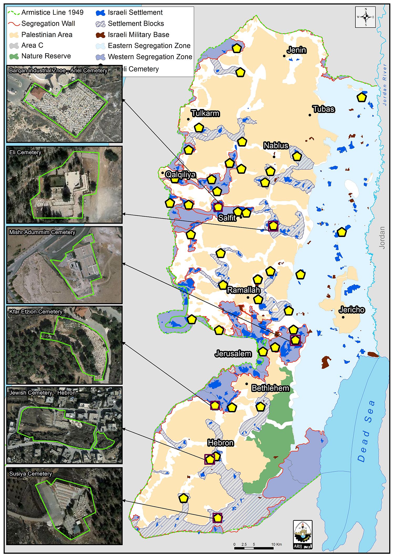
Map 5: location of the 42 Israeli cemeteries in the occupied West Bank
To conclude
Israel has paved the way for the construction of the cemetery and industrial zone by ,first, declaring the lands as “State Land”- lands belonging to the State of Israel – in 2016, so that it could implement its colonial plans in the area, while ignoring the fact that these lands belong to Palestinians in the first place, but have been denied access to these lands allegedly for being used as “firing areas/zones” and later by the construction of the Israeli Segregation wall[4] which separated Palestinians from their lands.
[1] The Western Segregation Zone: the area between the 1949 Armistice Line (Green Line) and the route of the Israeli Segregation wall.
[2] The “Blue Line Team” is a crew employed by the Israeli Civil Administration to investigate whatever Palestinian private land ownership exist within the land classified as State Land. However, the foremost task of the Blue Team is to look into the use of the Israeli Army of whatever State Land allocated to them under the pretext of security prior to year 1999. The land deemed as no longer of any “security” significance to the Israeli Army is turned back to the State Land Authority to be registered and allocated to settlement expansion or any security task related to the Israeli Army.
[4] On June 2002, the Israeli Government launched its policy of unilateral segregation within the Occupied Palestinian Territory (OPT) by establishing a Segregation Zone along the western terrains of the occupied West Bank. The Western Segregation Zone is the area west of the Segregation Wall that reaches to the Green Line. The Israeli Segregation Zone covers substantial and significant land areas, rich with natural resources (water aquifers) as it runs along the western part of the West Bank from north to south, seizing the most fertile agricultural lands, isolating Palestinian communities in enclaves, undermining the territorial contiguity between the Palestinian villages and cities, controlling the natural resources, and encapsulating and protecting most of the illegal Israeli settlements.
Prepared by
The Applied Research Institute – Jerusalem


