
Israeli settlement expansion booming in the occupied Palestinian territory at an unprecedented rate. During the second half of September 2016, the Israeli ministry of Interior published additional plans for new expansions to take place in five more Israeli settlements in the oPt. The expansions are to take place on 108 dunums of Palestinian land and will include residential housings, public parks, public building, engineering facilities, roads, and educational institutions. The targeted settlements are Beit Arye, Efrat, Modi'in Illit, Revava, and Giv’at Ze’ev. See Table 1
|
Table 1: Details of expansion plans in 7 Israeli settlements in the occupied West Bank |
|||||
|
No. |
Settlement Name |
Plan No. |
Area (dunums) |
Governorate |
Location from wall |
|
1 |
Beit Arye |
201/3/12 |
29.56 |
Ramallah |
West |
|
2 |
Mod’in Illit |
208/1/23 |
19.33 |
Ramallah |
West |
|
3 |
Efrat |
410/5/58 |
2.891 |
Bethlehem |
West |
|
4.1 |
Giv’at Zeev |
220/10/12 |
24.157 |
Jerusalem |
West |
|
4.2 |
220/10/11 |
11.599 |
|||
|
4.3 |
220/24 |
19 |
|||
|
5 |
Revava |
170/4/5 |
1.757 |
Salfit |
West |
|
Total |
108.294 |
|
|
||
|
Source: Israeli Ministry of Interior , September 2016 |
|||||
The settlements to be expanded are located west of the segregation wall route, in the area located between the 1949 Armistice Line and the route of the Segregation Wall, known today by “the Western Segregation Zone”. Israel plans to annex this area to its borders upon wall completion;
Two of the settlements slated for expansion are in Ramallah Governorate (Beit Arye and Modi’in Illit), two more in Bethlehem and Jerusalem Governorates (Efrat and Giv’at Ze’ev) and the final two are in Salfit Governorate (Revava and Elkana). Below is a brief of the targeted settlements and a breakdown of the plans’ details.
(1) Beit Arye settlement: It was established in 1981 on lands of Al Luban, Aboud and Deir Ghassanah communities in east Ramallah Governorate. In 2004, the settlement of Beit Arye was merged with Ofarim settlement. Today, both settlements occupy a total land area of 1958 dunums and are home to more than 4500 Israeli settlers. The construction of the Israeli segregation wall in the occupied West Bank has engulfed the Beit Arye-Ofarim settlements west of the wall, with the intention to annex it to Israel’s proper upon wall completion. See table 2 for details of plan No. 201/3/12
|
Table 2: Details of Plan No. 201/3/12 in Beit Arye settlement |
||
|
Land Type |
Area (Dunums) |
Percent |
|
Residential Area a |
1.22 |
4.12 |
|
Residential Area B |
7.77 |
26.28 |
|
Special Facility |
10.94 |
37 |
|
Roads |
8.96 |
30.31 |
|
Open public Park |
0.67 |
2.29 |
|
|
29.56 |
100 |
|
Source: Israeli military of Interior, 2016 |
||

Photo 1: Plan No. 201/3/12 in Beit Arye settlement
(2) Efrat settlement: It was established in 1979, on lands originally confiscated from the Palestinian villages of Artas and Al-Khader. Today the settlement occupies a total land area of 2513 dunums and houses 11447 Israeli settlers. Efrat settlement is located some 6.6 km from the 1949 Armistice line (Green line) and 5.3 km south of the city of Bethlehem. It is one of the 13 Israeli settlements comprising the so called “ Gush Etzion settlement bloc” southwest of Bethlehem city.
In 2002, Israel commenced the construction of the segregation wall in the oPt with great focus on Jerusalem city. Accordingly, the latest update route of the segregation wall showed that the wall is set to annex three major Israeli settlement blocs surrounding the city of Jerusalem, including Gush Etzion settlement bloc, while excluding 12 Palestinian communities nearby (pop +130,000) from the city’s municipal boundaries, to become on the eastern side of the wall. Table 3 is a breakdown of Plan No. 410/5/58 in Efrat Settlement
|
Table 3: Details of Plan No. 410/5/58 in Efrat Settlement |
||
|
Land Type |
Area (Dunums) |
Percent |
|
Residential Area a |
2.197 |
76 |
|
Roads |
0.504 |
17.43 |
|
Parking |
0.190 |
6.57 |
|
|
2.891 |
100 |
|
Source: Israeli military of Interior, 2016 |
||

Photo 2: Plan No. 410/5/58 in Efrat Settlement
(3) Modi’in Illit settlement: It was established in 1991 on lands of Deir Qiddis, Bil’in, Ni’in, Kharbatha in West Ramallah Governorate. The settlement occupies a total land area of 3724 dunums and is home to more than 63,000 Israeli settlers. Following the 1967 Israeli Army occupation of the Palestinian territory, the Israeli Authorities embarked on constructing Israeli settlements on Palestinian lands in an attempt to consolidate its illegal control over the Palestinian land. Over the years of occupation, Israel has succeeded in clustering the settlements into the form of blocs, meaning, establishing settlements in relatively close geographical areas. This, in turn, has led to the formation of five main Israeli settlement blocs in the oWB including Ariel-Kedumim settlement block, Modi’in Illit settlement bloc, Giv’at Ze’ev settlement bloc, Ma’ale Adumim settlement Bloc, and Gush Etzion Settlement bloc. With Israel’s decision to commence the construction of the segregation wall in the year 2002, it has facilitated the annexation of these blocs where it delineated the wall route in a way to affirm the definition of these blocs and eventually annex areas of great importance to Israel in all terms. Table 4 is a breakdown of the plan No. 208/1/23 in Modi’in Illit settlement
|
Table 4: Details of Plan No. 208/1/23 in Mod’in Illit settlement |
||
|
Land Type |
Area (Dunums) |
Percent |
|
Residential Area a |
3.70 |
19.14 |
|
Residential Area B |
4.26 |
22.06 |
|
Engineering Facilities |
0.16 |
0.83 |
|
Public buildings and learning |
0.78 |
4.03 |
|
Open space |
4.9 |
25.34 |
|
Proposed Road |
4.36 |
22.55 |
|
Approved Road |
0.01 |
0.05 |
|
Completed Road |
1.16 |
6 |
|
|
19.33 |
100 |
|
Source: Israeli military of Interior, 2016 |
||

Photo 3: Plan No. 208/1/23 in Mod’in Illit settlement
(4) Revava settlement: it was established in 1991 on lands of Deir Istya and Haris villages. Today, the settlement occupies a total land area of 732 dunums and is home to 1537 Israeli settlers.
Note that Israel is stepping up its settlement activity in Israeli settlements in the western segregation zone (WSZ), in the area that has become isolated between the 1949 Armistice Line (Green Line) and the Israeli Segregation Wall. Following Israel’s construction of the Segregation Wall in the oPt, Israel’s route of the wall showed that Revava settlement along with many others nearby (Ariel, Qiryat Netafim, Barqan Industrial, Ariel Indistrial, Sha’are Tekva, Elkana, Etz Efrayem, Revava, and Benot Orot Yesrael) comprising the Ariel settlement bloc are going to be on the western side of the wall and eventually become part of the new and illegally redrawn boundary of the West Bank, the part that is planned to be annexed to Israel upon the completion of the wall.
|
Table 5: Details of Plan No. 170/4/5 in Revava settlement |
||
|
Land Type |
Area (Dunums) |
Percent |
|
Residential Area C |
1.757 |
100 |
|
|
1.757 |
100 |
|
Source: Israeli military of Interior, 2016 |
||

Photo 4: Plan No. 170/4/5 in Revava settlement
(5) Giv’at Zeev settlement: the plans in Giv’at Ze’ev settlement are going to be implemented on 55 dunums of land. The settlement was established in 1982 on lands of Al Jib and Betunyia communities. Today, the settlement occupies a land area of 3001 dunums and is home to more than 16,700 Israeli settlers.
The settlement along with 6 others nearby (Beit Horon, Givon, Givon Hadasha, Neve Samuel and Har Samuel) comprise the Israeli so-called “Giv’at Ze’ev settlement bloc” northwest of Jerusalem city which is set to be annexed to Israel upon the completion of the Segregation wall in the oPt. Note that the latest Israeli Segregation Wall route published on the so-called “Israeli Ministry of Defense” website in 2007 shows the wall will surround the settlement Giv’at Ze’ev settlement bloc and annex it along with five other settlement blocs in the West Bank to Israel. Photos 5-7

Photo No. 5: Plan No. 220/10/12 in Giv'at Ze'ev settlement

Photo No. 6: Plan No. 220/10/11 in Giv'at Ze'ev settlement

Photo No. 7: Plan No. 220/24 in Giv'at Ze'ev settlement
In fact Israel has constantly planned to retain control of settlement blocs in the oPt as the previously published maps of the segregation Wall (2002-2007) indicated that the wall has never been planned to maintain security in the oPt as claimed, but rather to grab Palestinian land for the sake of future settlement development. Table 6 below gives details of the expansion Plans in Giv’at Ze’ev settlement:-
|
Table 6: Details of Plan No. 220/10/12, Plan No. 220/10/11 & Plan No. 220/24 |
|||
|
Land Type |
220/10/12 Area (Dunums) |
220/10/11 Area (Dunums) |
220/24 |
|
Residential Area A |
6.379 |
—– |
—– |
|
Residential Area D |
—– |
—– |
3.349 |
|
Residential Area B |
11.431 |
5.923 |
—– |
|
Residential Area C |
—– |
3.910 |
—– |
|
Residential Area D – Educational |
—– |
—– |
1.266 |
|
Buildings and public institutions |
0.716 |
1.418 |
—– |
|
Facilities for future use |
—– |
—– |
3.040 |
|
Approved Road |
—– |
—– |
1.922 |
|
Public Park |
0.567 |
0.348 |
3.388 |
|
Proposed Road |
4.921 |
—– |
5.158 |
|
Sports and Recreation |
—– |
—– |
0.774 |
|
Engineering Facilities |
0.143 |
—– |
0.103 |
|
Total |
24.157 |
11.599 |
19 |
|
Grand Total |
54.756 |
||
|
Source: Israeli military of Interior, 2016 |
|||
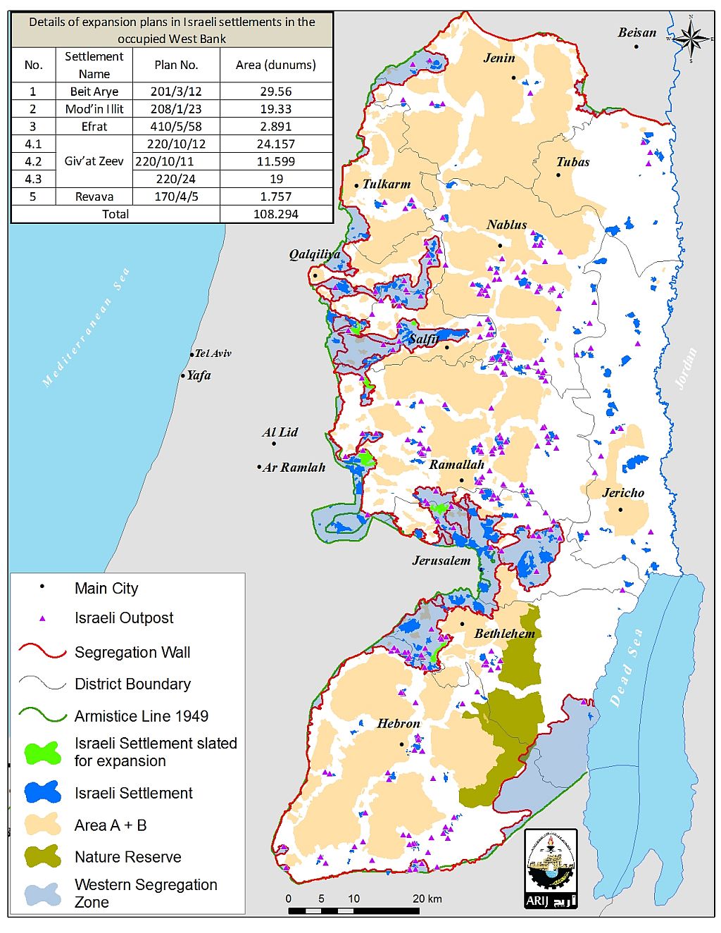
Map 1: Location of the settlements slated for expansion in the oPt
To conclude,
The encroachment of Israeli settlements on Palestinian villages is a growing danger that threatens the development of Palestinian communities in the future. Not only does it deprive them of valuable agricultural and grazing lands but it also puts physical barriers to their natural growth and disconnects them from each other.
Note that the Israeli Segregation Wall runs for 773 km in the occupied West Bank. When complete, the wall will isolate 733 km2 of Palestinian land in the West Bank (approximately 13% of the total area), including 103 Israeli settlements, 60 outposts, open spaces and natural resources. within its path.
The Israeli Government's construction of settlement outposts in the Occupied Palestinian Territories violates numerous statutes of international humanitarian law, including: the Fourth Geneva Convention of 1949, Article 49 (para. 6) which states: 'The occupying power shall not deport or transfer parts of its own population into the territories it occupies,' and article 53 of the same Convention which prohibits 'any destruction by the Occupying Power of real or personal property belonging individually or collectively to private persons, or to the State, or to other public authorities, or to social or cooperative organizations, is prohibited, except where such destruction is rendered absolutely necessary by military operations.'
The Hague Regulations of 1907, Article 23 of which prohibits the destruction or seizure of occupied property, unless it is imperatively demanded by military necessity.
United Nations Security Council Resolution 242 (1967) which requires Israeli armed forces to withdraw from 'the territories occupied' in the 1967 war, including the West Bank and Gaza Strip.
United Nations Security Council Resolution 452 (1979) which calls upon 'the Government and people of Israel to cease, on an urgent basis, the establishment, construction and planning of settlements in the Arab territories occupied since 1967, including Jerusalem.'
United Nations Security Council Resolution 465 (1980) which 'Determines that all measures taken by Israel to change the physical character, demographic composition, institutional structure of status of the Palestinian and other Arab territories occupied since 1967, including Jerusalem, or any part thereof, have no legal validity and that Israel's policy and practices of setting parts of its population and new Immigrants in those territories constitute a flagrant violation of the fourth Geneva convention relative to the protection of civilian persons in time of war and also constitute a serious obstruction to achieving a comprehensive, just and lasting peace in the Middle East.'
Prepared by:
The Applied Research Institute – Jerusalem


