The Israeli planning and construction committee affiliated to the Jerusalem municipality approved on the 30th of March 2016 the deposit of TPS number 152552 to construct 18 settlement units in Al Farouk neighborhood in the Palestinian town of Jabal al Mukabbir in occupied Jerusalem. The construction to take place is actually an extension to an existing building claimed to be bought by Elad Jewish organization back in 2013, an entity that works to increase the Jewish presence in the occupied city of Jerusalem. The plan also calls for the retroactive legalization of previous construction that took place in the site during the last couple of years without proper building authorization from the Municipality of Jerusalem – four out of five stories – in addition to the construction of a new building in the area, raising the number of settlement units in the area to 18.
Note that in June 2009, Israel also approved the deposit of TPS No.10188 which states a change in the zoning area of a public green space to the north of East Telpiot settlement (which is actually an existing planted forest named Ya'ar Hashalom) to establish a public park and recreation area for active recreation forest. The plan targets almost 551 dunums (which is the area of the forest) and will benefit the settlement of East Telpiot and settlements in Jerusalem. See Map 1

Map 1: Location of the Building claimed to be bought by El Ad Jewish organization in Jabal Al Mukkabir
Note that the building which is claimed to be bought by El Ad Jewish organization and awaiting expansion is located in close proximity of the Ya'ar Hashalom Forest.
Israeli settlements established on lands of Jabal Al Mukkabir
During the years of the Israeli occupation of the Palestinian territory, the successive Israeli governments supported the building and expansion of settlements in the occupied West Bank, including East Jerusalem, many of which began as military settlements (Nahal in Hebrew) and eventually were transferred to civilian settlements. Today, 196 illegal Israeli settlements stand on lands of the occupied West Bank, including 35 in occupied East Jerusalem.
Jabal Al Mukkabir town was no different from the rest of the Palestinian communities in the West Bank or from those located within the illegally and unilaterally declared municipal boundary of Jerusalem which lost their lands for the construction of either settlements, military bases or bypass roads. The town witnessed the loss of more than 600 dunums of its lands for the establishment of two Israeli settlements, ‘East Talpiot’ in 1973 and ‘Nof Zion’ in 2004. Table 1 gives details of the two settlements established on lands of Jabal Al Mukkabir
|
Table 1: Israeli settlements constructed on lands of Jabal Al Mukabbir town |
|||||
|
|
Settlement name |
Year of construction |
Area confiscated from Jabal al Mukabbir (dunums) |
Total settlement area (dunums) |
Population of settlers (ARIJ, 2015) |
|
1 |
East Telpiot |
1973 |
350 |
1829 |
17,000 |
|
2 |
Nof Zion |
2004 |
44 |
44 |
418 |
|
|
Total |
|
|
|
|
|
Source: ARIJ-GIS Unit, 2015 |
|||||
Over the years of occupation, Israel continued its settlement activity in the oPt with great focus on Jerusalem; this was exemplified in the publishing of building plans and tenders and even mapping lands as “Green Areas” or “military or firing zones” to preserve them for future settlement urban expansion and development. This policy further fragmented the occupied West Bank, and most specifically the occupied city of Jerusalem and negatively affected it demography for the favor of the Jewish presence in the city of Jerusalem, in order to “Judaize” it.
In Jabal Al Mukkabir community, several building plans and tenders were published for the expansion of the aforementioned settlements in addition to declaring an area to its northwest as “Green Area” to prevent Palestinians from utilizing it in the future. Table 2 lists some of the Israeli plans that were published to expand settlements in the area
Table 2: Israeli plans in East Telpiot Settlement in occupied East Jerusalem
|
No. |
Plan No. |
Area as stated in the plan (Dunums) |
No. of units |
Date of Publish |
|
1 |
11963 |
0.424 |
|
18/8/2008 |
|
2 |
12105 |
0.44 |
|
18/8/2008 |
|
|
1423 |
49.077 |
|
4/2/1971 |
|
3 |
1423D |
28.192 |
|
14/2/1991 |
|
4 |
1714A |
131.258 |
|
5/10/1975 |
|
5 |
1805 |
2 |
|
8/3/1973 |
|
6 |
2074 |
150 |
|
19/9/1975 |
|
7 |
2560 |
66 |
|
13/12/1979 |
|
8 |
2626 |
110 |
|
21/6/1981 |
|
9 |
2634A |
95 |
|
28/2/1985 |
|
10 |
2634B |
75.18 |
|
6/4/2000 |
|
11 |
2782 |
11 |
|
3/3/1983 |
|
|
2782A |
13 |
|
5/5/1987 |
|
12 |
2823 |
101 |
|
10/6/1982 |
|
13 |
3080 |
166.152 |
|
29/12/1983 |
|
14 |
3407 |
42 |
|
23/5/1985 |
|
15 |
3433 |
8 |
93 |
29/3/1985 |
|
16 |
3756 |
6.038 |
|
19/12/1991 |
|
17 |
3817 |
8.859 |
36 |
22/9/1988 |
|
18 |
4003 |
11.782 |
|
12/10/1990 |
|
19 |
4062 |
8.859 |
|
22/9/1988 |
|
20 |
4165 |
3.892 |
|
29/8/1991 |
|
21 |
4548D |
114.4 |
|
30/03/2005 |
|
22 |
4548I |
|
A network of Roads |
16/07/2003 |
|
23 |
4548 |
125.7 |
A Road |
30/12/2008 |
|
24 |
4548B |
253.4 |
A Road |
08/05/2005 |
|
25 |
4548H |
200.4 |
A Road |
21/03/2005 |
|
26 |
4548O |
|
A network of Roads |
|
|
27 |
4711 |
74 |
1330 |
31/8/2011 |
|
28 |
4748 |
275 |
|
22/6/1995 |
|
29 |
4798A |
7.4 |
|
4/9/2007 |
|
30 |
6120 |
3.597 |
|
19/9/2000 |
|
31 |
7977 |
67.176 |
180 |
5/4/2005 |
|
32 |
7984 |
262.424 |
440 |
5/4/2005 |
|
Source: Israeli Land Authority |
||||

Map 1: Israeli building plans in East Telpiot Settlement in occupied East Jerusalem
A glimpse of Jabal al Mukabbir
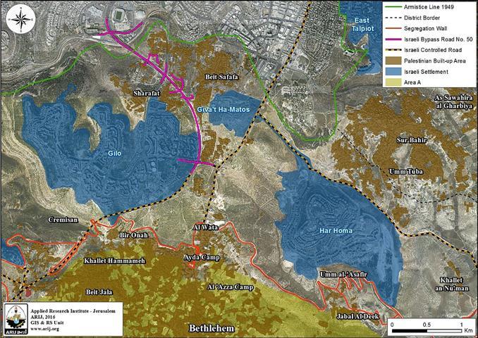
A Palestinian town to the south of Jerusalem city. It is bordered by Abu Dis and As Sawahira ash Sharqiya to the east, Silwan and Jerusalem city to the north, Ath Thuri and Sur Bahir to the west, and Ash Sheikh Sa’d and Sur Bahir to the south (ARIJ-GIS Unit, 2015). The town has a population over 21,000 Palestinians, 80% of whom, hold Jerusalem ID cards[1].
The town of Jabal al Mukabbir is located under the control of the Israeli Jerusalem Municipality, which was illegally and unilaterally declared in 1967 after the Israeli occupation of the West Bank including East Jerusalem and the Gaza Strip. Upon this declaration, Jerusalem Governorate was divided into two main regions, J1 and J2. The J1 area is located inside the borders of Jerusalem Municipality and under its control, and includes many Palestinian communities[2] including Jabal al Mukabbir which are located in J1’s southern area. The other region is J2, which is located outside the borders of Jerusalem Municipality and is under the control of the Palestinian National Authority.
The Israeli Segregation Wall plan
The Israeli Occupation Authorities have used their separation plan, represented by the construction of the Segregation Wall, to again redraw the boundaries of Jerusalem Municipality with the aim to create a de facto situation in favor of the Jewish presence in the city. The Segregation Wall has separated the whole area of J1 from Jerusalem Governorate except for Kafr ‘Aqab and Shu’fat refugee Camp fro the rest of Jerusalem Governorate and the West Bank. According to the Oslo II Interim Agreement signed between the Palestinian Liberation Organization (PLO) and Israel on 28th September 1995, the West Bank was classified into areas “A,” “B” and “C” which aimed at a phased withdrawal of the Israeli military forces from these areas until the accomplishment of a final status agreement. The towns of Jabal al Mukabbir was not subjected to this classification, and remained as they were before this agreement under the control of Israeli Jerusalem Municipality.
The construction of the Israeli Segregation Wall has negative impacts on Jabal al Mukabbir town and its population. According to the latest amendment of the Segregation wall plan published on the Israeli Defense Ministry website on 30th April 2007, the Segregation Wall entirely isolates Jabal al Mukabbir town from the neighboring Palestinian communities that became on the eastern side of the wall. The fact that the Wall segregates the town of Jabal Al Mukkabir and the whole J1 area from the rest of West Bank and from localities within the Jerusalem Governorate boundary[3] is particularly devastating, as it has historical relations with these towns. See Map 1

Map 1: Location Map of Jabal Al Mukkabir Town in occupied East Jerusalem
Settlement Building in International Law
The establishment of settlements in the occupied West Bank violates international humanitarian law which establishes principles that apply during war and occupation. Moreover, the settlements lead to the infringement of international human rights law.
The Fourth Geneva Convention prohibits an occupying power from transferring citizens from its own territory to the occupied territory (Article 49). The Hague Regulations prohibit an occupying power from undertaking permanent changes in the occupied area unless these are due to military needs in the narrow sense of the term, or unless they are undertaken for the benefit of the local population.
The establishment of settlements results in the violation of the rights of Palestinians as enshrined in international human rights law. Among other violations, the settlements infringe the right to self-determination, equality, property, an adequate standard of living, and freedom of movement.
[1] Jabal al Mukabbir & As Sawahira al Gharbiya Town Profile
http://vprofile.arij.org/jerusalem/pdfs/vprofile/jabalalmukabber.pdf
[2] Sur Baher, Um Tuba, Sharafat, Beit Safafa, As Sawahra Al Gharbiya, Jabal Al MukkabiR, Ath Thuri, Silwan, Jerusalem, Al Isawiya, Shu’fat, Beit Hanina, Part of Qalandyia, Part of Hizma, Part of Kafr Aqab.
[3] such as Abu Dis, As Sawahira ash Sharqiya and Ash Sheikh Sa’d,
Prepared by:
The Applied Research Institute – Jerusalem