On the 10th of December 2015, the Peace Now organization[1] revealed that the Israeli Civil Administration issued a military order which declared about 30 dunums of Palestinian land in Deir Istiya village in Salfit Governorate and Jinsafut village in Qalqiliya Governorate, as “State Land”.
The military order was issued by the so-called “The Custodian of Absentee property & Israel Land Authority of Judea and Samaria” attached to the Israeli Ministry of Defense/Civil Administration, Yousi Sigal, on the 21st of October 2015 which declared about 29.750 dunums of Palestinian land in Jinsafut and Deir Istiya villages, as “State land”.


According to the military order, the "Custodian of the Absente Property” based in his decision to an illegal Israeli law issued following the Israeli military Occupation of the Palestinian Territory in 1967- (Order Concerning State Property (Judea & Samaria) (No. 59-1967)). According to the order ,the Palestinian landowners can submit their petitions against the aforementioned order within 45 days at the Israeli objections committee No. 172 (Judea & Samaria) 1967, in Ofra military base, which located in Ramallah Governorate.
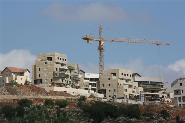
The analysis done by the Geo-Informatics department in the Applied Research Institute- Jerusalem (ARIJ), showed that the targeted lands, which divided to three location, located inside the border of two illegal Israeli settlements of; Ginnot Shomron and Neve Oranim, and within the master plans of the aforementioned settlements. And the “State land” declaration came after the Israeli Authorities and settlers used the targeted lands to expand the aforementioned two Israeli settlements by constructing new housing units and road networks.See the map No.1

Map No. 1: The targeted Palestinian lands
The declaration of 30 dunums of Palestinian land as State land, and which were used by the Israeli Authorities and settlers to expand the Israeli settlements of Ginnot Shomeron and Neve Oranim, means that the Israeli Authorities retroactively legalize the construction in the aforementioned settlements and to allow it to expand.
The satellite images for the targeted lands also showed the following:
- The first location of the targeted land, lies within the village boundary of Deir Istiya village in Salfit Governorate, and west of the illegal Israeli settlement of Ginnot Shomron. The total area of the targeted land reach to 6.4 dunums. The Israeli Authorities used the land to construct a number of housing units and roads, which aimed to expand the settlement westward.

- The second location of the targeted land, also lies within the village boundary of Deir Istiya village, and located south of the illegal Israeli settlement of Ginnot Shomeron. The total area of the targeted land is about 7.7 dunums. The Israeli Authorities used the targeted land to build a number of housing units and road network.

In total the Israeli Occupation Authorities declared 14.1 dunums of Palestinian land in Deir Istiya village as “State land”, and the targeted land used by the Israeli settlers and Authorities to expand the illegal Israeli settlement of Ginnot Shomeron from the south and west.
3. The third location of the targeted land, located within the village boundary of Jinsafut village in Qalqiliya Governorate, and east of the illegal Israeli settlement of Neve Oranim. The area of the targeted land is about 16.2 dunums, where the Israeli Authorities prepared the land to construct new housing units, and the Israeli settlers already established a roads that will benefit the new expansion of the settlement.

The military orders which declared in total more than 30 dunums of Palestinian lands in the two Palestinian villages of Deir Istiya and Jinsafut, are a clear example for the Israeli Authorities confiscation of Palestinian lands under several pretext, such as State land, and granted the land to the Israeli settlers to expand the illegal Israeli settlements and to build the outposts.
It’s not the first time that the Israeli Authorities declared Palestinian land as “State Land” to allow the expansion of the Israeli settlements, where in August 2014, the Israeli Authorities issued an order which declared 3799 dunums of Palestinian land in Bethlehem and Hebron Governorates, as “State land”. The declaration of State land was aimed to expand the Israeli settlements in Gush Etzion settlement bloc. For more information about this case, check the link:
https://poica.org/details.php?Article=6886
A strategic declaration… Israel expand the Kedumim “finger” settlement bloc
It’s worth to mention that the new “State land” is a strategic one, because the illegal Israeli settlements of Ginnot Shomeron and Neve Oranim located within the illegal Israeli settlement bloc of Kedumim (“Settlement bloc”, is an informal term, referring to areas in the occupied West Bank where clusters of settlements have been established in relatively close proximity to one another[2]), which created by the Israeli Authorities after the construction of the segregation wall.
Indeed, Kedumim settlement bloc located in area known as “the western segregation zone”, the area that located at the western part of the segregation wall.
It’s important to point that in the current political context, the term “settlement bloc” has become a code name for those settlements that are supposedly within the Israeli national “consensus” as being settlements that should and likely will remain part of Israel under any future peace agreement.
Since the construction took place inside the border of the “Settlement bloc”, the Israeli Authorities claimed that it’s “legal”, and isn’t inconsistent with the Peace Process.
As a matter of fact, all the Israeli procedures, such as the construction of the segregation wall, establishment of the Israeli settlements and outposts, in the occupied Palestinian territory are “illegal” and inconsistent with the international law rules and the United Nations Security Council Resolutions.
The illegal Israeli settlement of Neve Oranim :
Neve Oranim is an Israeli settlement established in the year of 1991 on Palestinian lands in Qalqiliya Governorate. The total area of the settlement reach to 581 dunums and inhabited by 262 Israeli settlers according to statistic of the year 2011.
The illegal Israeli settlement of Ginnot Shomeron:
Ginnot Shomeron is an Israeli settlement established in the year of 1985 on Palestinian lands in Salfit Governorate. The total area of the settlement about 1,041 dunums.
Deir Istiya town:
Deir Istiya is a Palestinian town in Salfit Governorate. It is bordered by Zeita Jamma’in in Nablus Governorate and Kifl Haris village to the east, Haris and Qarawat Bani Hassan to the south, Kafr Thulth and ‘Azzun villages in Qalqiliya Governorate to the west, and Kafr Laqif, Jinsafut and Immatin villages in Qalqiliya Governorate to the north.
For more information about Deir Istiya village:
http://vprofile.arij.org/salfit/pdfs/vprofile/Deir.pdf
Jinsafut village:
Jinsafut is a Palestinian village in Qalqiliya Governorate. It is bordered by Immatin village to the east, Deir Istiya village (in Salfit Governorate) to the south, Wadi Qana (in Salfit Governorate) to the west and Hajja to the north.
For more information about Jinsafut village:
http://vprofile.arij.org/qalqiliya/pdfs/vprofile/Jinsafut_vp_en.pdf
To sum up:
The existence of the Israeli settlements in the West Bank and their expansions are Illegal and contradicts with the international law rules, United Nations Security Council Resolutions such as 237 (1967), 271 (1969), 446 (1979), 452 (1979) ,465 (1980).
- Resolution 446 March 22, 1979 calls on Israel to rescind its previous measures and to desist from taking any action which would result in changing the legal status and geographical nature and materially affecting the demographic composition of the Arab territories occupied since 1967, including Jerusalem and, in particular, not to transfer parts of its own civilian population into the occupied Arab territories"
- Also the resolution 452 of the 1979 “calls upon the Government and people of Israel to cease, on an urgent basis, the establishment, construction and planning of settlements in the Arab Territories since 1967 including east Jerusalem.
- United Nation Security Council Resolution 452 of 1979: 'Calls upon the Government and people of Israel to cease, on an urgent basis, the establishment, construction and planning of settlements in the Arab occupied Territory since 1967, including Jerusalem.'
- Article 49 of the Fourth Geneva Convention of 1949: 'the occupying power shall not deport or transfer parts of its own population into the Territory it occupies.'
- The Roadmap of Peace signed on April 30, 2003 between Israel and the Palestinians (originally developed by the United States, in cooperation with Russia, the European Union, and the United Nations (the Quartet)) under which the Israeli Government agreed to freeze all settlement, indicated that: The -Government of Israel- immediately dismantles settlement outposts erected since March 2001, and, consistent with the Mitchell Report, [Government of Israel] freezes all settlement activity (including natural growth of settlements).The plan was adopted by the USCR 1515-2003.
[1] http://peacenow.org.il/eng/KerniShormonDeclaration
[2] http://peacenow.org.il/eng/content/west-bank-%E2%80%9Csettlement-blocs%E2%80%9Db
Prepared by:
The Applied Research Institute – Jerusalem


