For decades Israel’s repeated confiscations of the Palestinian territory land have exerted a heavy toll on the Palestinian population and have become a critical obstacle in the development of more strategies to address the Israeli-Palestinian conflict. In fact, Israel’s far most interest is to establish a peace that ensures security to its citizens and sustainability of its settlements in the occupied Palestinian territory with no regard of the negative impact on Palestinians.
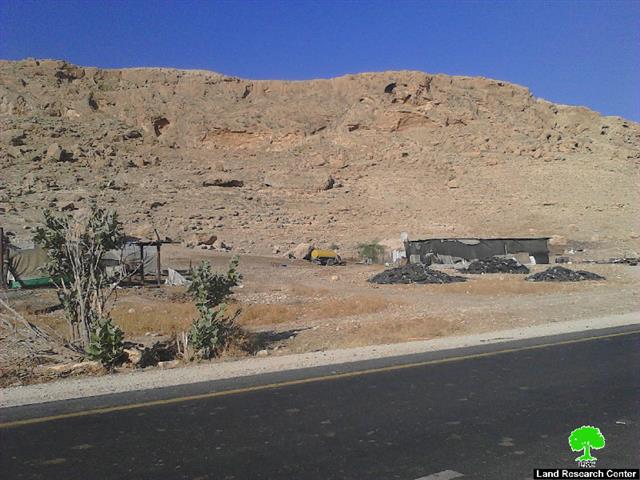
In late May 2015, the Israeli occupation Authorities decided to confiscate 820 dunums of land in Ramallah Governorate to establish a landfill (dumping site) that would serve the Israeli settlements in the eastern part of Ramallah Governorate. The Israeli authorities claim that the landfill would also serve the Palestinian communities located in east Ramallah Governorate such as Rammun, At Tayba, Deir Dibwan and Deir Jarir and other surrounding communities, but the fact that the planned landfill site is located in Area "C", which according to the Oslo II Interim Agreement of 1995, falls under the full Israeli control, security and administratively; Israel most probably would impose full control over the management of the landfill without allowing Palestinians any control over the site despite the fact that the targeted lands are owned by Palestinians of Deir Dibwan and Rammun communities.
And Based on the framework agreement between the Palestinian National Authority and the German Government, the KfW Entwicklungsbank (KfW) have contracted with the consortium of ERM GmbH and GOPA, Germany, with the subcontracted Centre for Environment & Occupational Health Sciences (CEOHS) of Birzeit University, Palestine and Ingenieurbüro Sehlhoff, Germany to carry out the Elaboration of a Feasibility Study for a Regional Solid Waste Management System for the Ramallah / Al Bireh District (Update Concept Report, 2008)
The envisaged achievements of the project was to establish an environmentally sound management of urban areas and the commercial, industrial and hospital waste in the project area, including waste avoidance and recycling and improvement of collection and disposal, in conjunction with appropriate pre-treatment and give support for the effective implementation and continuing operation of the landfill in the future[1].
The Israeli occupation authorities have always stood in the way of implementing the project in spite of the availability of the necessary funding. This is because the location of the landfill site is in Area “C” which requires the implementing agency to get the approval of the Israeli Authorities on implementing such a project.
Not until 2007 that the Israeli occupation authorities gave its primarily approval to the project, along the Israeli bypass road number 449, south-west of Rimmunim settlement; however, the Israeli approval to the project at that time came to serve several goals, all of which fall in the Israeli interest. Below are some key figures to help understand the Israeli goals behind the confiscation process:
- The fact that the area in which the landfill is planned to be implemented is classified as Area "C", according to the Oslo II Interim agreement of 1995. In this case, Israel is the most beneficial of the project by controlling the area under the pretext of establishing the landfill and the imposition of its management over the site.
- It is likely that Israel confiscates more Palestinian land in the surrounding area allegedly for "developing or expanding the landfill" in the future and thus controlling the only remaining open area of Rimmon and Deir Dibwan communities for future colonial expansion.
- Israel's announcement of the confiscation of the land is to impose a new reality on the ground that cannot be bargained over in the future, and to sustain the existence of settlements and outposts in the area through including them in the landfill project.
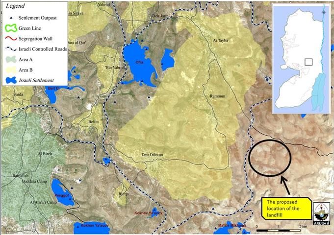
- The targeted landfill site is an "open area" and is rich with natural resources, agricultural land and water sources, which puts the area under the focus of the Israeli occupation authorities. See Map 1

Map 1: the location of the landfill on lands of Rammun and Deir Dibwan communities
Israel seeks to impose a new reality on the ground
Since Israel started the construction of the Segregation Wall in the occupied West Bank in June 2002, it stated that the wall will be built on the basis of securing the state of Israel and its citizens from the “Palestinian Terrorism”, as claimed. However, the wall is a long-termed plan that aimed at grabbing as much Palestinian land as possible along with natural resources and controlling the Palestinian territory for the sake of sustaining the future of Israeli settlements illegally built on the territory it occupied in 1967.
So far, Israel has completed the construction of more than 60% of the wall in the occupied Palestinian territory and plans to annex 107 Israeli settlements to its unilateral created borders upon wall completion. However, the plan of the Israeli Segregation wall did not meet the needs and aspirations of Israel's settlement project because many of the Israeli settlements that are of strategic, geographic and religious importance have remained outside the wall path (on the eastern side of the wall), and Israel has not been included in any colonial plan. This is the case of Israeli settlements that surround the targeted landfill site such as Ma’ale Mikhmas settlement south of Rammun and Deir Dibwan communities, and the settlements of Rimmunim and Kochav Hashahar in the northeastern side, the settlements of Kochav Yacov and Pesagot in the northwestern side, and the settlements of Beit El and Ofra in the eastern side of the these communities. Ultimately, Israel seeks to create a new settlement bloc in the area that combines the aforementioned settlements under one roof since the area is of high strategic importance to Israel and is considered as a geographical link between settlements in the Jordan Valley and Dead sea area (the Eastern Segregation Zone) and Israeli settlements west of Ramallah (Dolev and Talmon and Nahlaiel) and Israeli settlements inside the Western Segregation Zone.
To Conclude,
Regardless of the type of settlement project in the area, Israel continues to target land in area "C" in the occupied West Bank as part of its ongoing quest to exploit these areas for the various Israeli settlement projects and keep them under its control. By doing so, Israel ensures its eternal control over the land and thus, Palestinians lose their right to acquire these lands from Israel under any future agreement.
[1] Elaboration of a Feasibility Study for a Regional Solid Waste Management
System for the Ramallah / Al Bireh District(SWM RAMALLAH/ AL BIREH GOVERNORATE, KFW, Update Concept Report)
Prepared by:
The Applied Research Institute – Jerusalem