
Location and Area:
Wadi Qana is located 10km northwest of Salfit governorate. It is surrounded by the village of Kfar Laqif from the north, Azzun Village from the southwestern side and the village of Kfar Thulth from the west. The colonies of Nofim and Yakir are located there from the east where the villages of Deir Istiya and Qarawat Bani Hassan are situated there from the southeast.
The Wadi is relative to Deir Istiya that is of 34,129 dunum in area of which 10,000dunum is the overall area of Wadi Qana and 13 dunum is the built-up area.
The area is classified as a natural slope situated between two mountains and is famous for its beautiful nature, land fertility, and water abundance. Therefore, the occupation has been attempting on changing the landmarks of the area by conducting the strategy of lands confiscation for the sake of colonial plans.
According to Oslo Accord lands classification, Deir Istiya has around 6,132(18% of the overall area of the village) dunum that are classified as area B and around 27,997 dunum are classified as area C (82% of the village overall area), taking into consideration that all the lands of Wadi Qana are classified as area C.
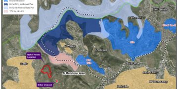
A plan to open a colonial road that links all colonies located on the lands of Wadi Qana threats more than 10,000 dunum of the area:
On July 7th 2014, peace movement "Now" revealed a map issued by the council of colonies in the West Bank, which include a recently prepared Israeli plan that mainly aims at bypassing around the area of Wadi Qana, north of the West Bank for the sake of Judaizing it and to firmly impose control over it. As a result, thousands of dunums will be threatened of takeover, segregation, and inaccessibility.
The plan is centered on establishing a network of bypass roads in the area of Wadi Qana, which connect all colonies of the nearby to each other. This would eventually create a regional council that unites all of the seven colonies located in the periphery of the Wadi.
According to the explanatory attached map, the plan includes shutting down a number of agricultural lands, which serve tens of agricultural dunums used by villagers and farmers since too many years ago. The roads are (Ein al-Bassa, al-Tannur, and Ein al-Fawwar).

The map of the plan as reaveled by " NOW" peace movment:


Intensifying landmarks change and colonial activities in Wadi Qana:
The mayor of Deir Istiya Ayoub Abu Hajalih, about the plan's futuristic repercussions on the Palestinian human and land, to the LRC researcher stated the following:
" the plan will not only intensify the colonial activities in the area but it will give the green light to confiscate more lands and establish new outposts all over the place. If implemented, the plan will segregate the area of Wadi Qana from the Palestinian periphery. This will help Judaizing the area to fully control it".
It is known that before embarking any work of expansion on colonies in the West Bank, the occupation opens new roads and expands the infrastructure. The bypass roads revealed in the new plan are considered the foundation base for colonies' expansion in Wadi Qana, which will eventually become a massive colonial mass that gathers all the neighboring colonies.
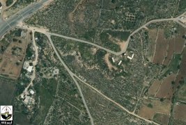
The occupation legitimizes the outpost of El Matan and annex 100 agricultural dunums from Wad Qana to it
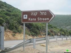
Haaretz newspaper featured an advertisement, on October 2d 2014, ratifying a master plan for El Matan outpost, which was established in 2000 nearby the natural reserve named Nahal Kanna on the lands of Wad Qana.
According to the master plan, 100 dunums will be confiscated from Wad Qana for the favor of that outpost. Land status will be changed from agricultural to a built-up as a result.
The outpost is located atop of a hill in the heart of Wad Qana; it overlooks a number of water springs for which the area is famous namely ( al-Fawwara spring and al-Jouza spring). Those lands belong to farmers from the town of Deir Istiya.
Since its establishment, El Matan has been limiting the Palestinian presence in the area where colonists carried out a big number of violations and attacks on farmers in addition to trees uprooting and cutoff. Noteworthy, the outpost of El Matan is only inhabited by 20 right-wing families who reside in caravans under extreme protection of the army of the Israeli occupation.

El Matan Outpost

Wadi Qana and El Matan outpost
The executioner and the judge are one:
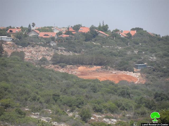
It should be marked that the Israeli occupation legislated laws relative to nature protection in the area of Wadi Qana, which is classified, by the occupation, as a natural reserve. Implementing those laws, tens of seedlings were uprooted in addition to a number of agricultural roads that were shut down under the pretext of protecting the nature.
An observer can witness the ravaging activities and lands confiscation in the area. In addition, uprooting fruitful trees for the sake of expansion is obviously seen in there. Not only that, Palestinians have been denied access to their lands as opposed to colonists who have the absolute right to picnic in the area under the protection of the Israeli army. Are enacted laws only to be applied on Palestinians rather than the occupation itself?

Colonists use Wadi Qana for recreational activities where Palestinian farmers are denied access to the place
Wadi Qana is" Suffocated" by the Israeli colonies and the apartheid wall:

Wadi Qana is surrounded by 7 Israeli colonies which devour lands and cause drastic damage to the environment. These colonies are Karne Shomron, Ginat Shomron, and Nov Uranium (north), Yakir and Nofim (south) and Emmanuel (east). The former colony dumps its wastewater into the valley which polluted the water springs of (al-Juza and al-Fawwar). The wastewater reached out the pools( watersheds) of al Bassa and al-Jamal. The colony of Maale Shomron that is located to the west of Wadi Qana is forming a imminent danger on the area which lands are shrinking and whose people are being displaced within a systematic plan undertaken by colonists so they be able to expropriate Palestinian properties. In addition, the outpost Nov Uranim which stands in the middle of the valley dumps its waste (solid and nonsolid) in the valley which severely damaged the environment( fauna and flora) and forced many Palestinian residents to evacuate.
It is indicated that the area of planted lands in Wadi Qana has notably decreased from 10,000 dunum to 5,500 dunum because of the surrounding colonies and the occupation banning famers to reach their lands. The Wadi lost more than half of its agricultural lands a result of establishing colonies on its lands. Colonists frequent assaults on farmers, who attempt to reach their lands located in the colonies' peripheries, made the lands become arid and unsuitable for plantation.
It should be marked that the occupation confiscated around 7,590 dunum of which 4,024 dunum is for the favor of colonies located on the lands of the Wadi and 1,864 dunum is for the favor of the bypass roads no. (55,5506).
In addition, the apartheid wall destroyed about 1,702 dunum as for the wall's route of construction and segregated around 1,010 dunum behind it. After the wall's(17,023 m in length) completion, an area of 18,411 dunum will be segregated behind the wall.
The following table shows information about colonies located on the lands of Wadi Qana and or its periphery in addition to total area of confiscated lands:
|
|
Colony name |
Year of establishment |
Confiscated area/dunum |
No. of colonists |
|
|
Revava |
1991 |
167 |
703 |
|
|
YAKIR |
1981 |
757 |
932 |
|
|
Maale Shomron |
1980 |
74 |
533 |
|
|
Ginat Shomron |
1985 |
944 |
(..) |
|
|
Karne Shomron |
1978 |
540 |
6093 |
|
|
Nofim |
1986 |
663 |
402 |
|
|
Emmanuel |
1981 |
879 |
2455 |
|
Total |
4024 |
11118 |
||
(…) unknown number
Source: Geographical Information System- Land Research Center, until 2007.
During the past five years, Wadi Qana has witnessed vicious attacks on land and trees. In the same time the occupation serves military orders to uproot trees under the pretext of lands being a natural reserve, the machineries of the occupation have been ravaging Palestinian lands for the favor Israeli colonies and their expansion.
According to department of Monitoring Israeli Violations- Land Research Center , Israeli assaults undertaken by colonists in the past five years in the period between 2010- November 2014 were documented as follows:
The following table shows the violated lands in Wadi Qana within the past five years(2010-2014):
|
Year |
Ravaging/ dunum |
Pumping wastewater/ dunum |
Torching/ dunum |
Chemicals poison/ dunum |
Stealing soil for colonies/ dunum |
Damaged lands by Unleashing wild pigs/dunum |
Used for Military training/ dunum |
The total damaged area/dunum |
|
2010 |
40 |
|
|
10 |
|
|
|
50 |
|
2011 |
55 |
20 |
5 |
|
|
|
|
80 |
|
2012 |
32 |
125 |
|
|
12 |
|
|
169 |
|
2013 |
61 |
|
|
|
|
25 |
10 |
96 |
|
Until November 2014 |
155 |
|
|
|
|
|
|
155 |
|
Total |
343 |
145 |
5 |
10 |
12 |
25 |
10 |
550 |
Source: field documentation- Monitoring Israeli Violations team- Land Research Center- Arab Studies Society 2010-2014
The following table shows information about the affected trees in Wadi Qana during the past five years :
|
Year |
No. of burnt trees |
No. of uprooted trees |
No. of affected trees by: |
Looting |
Notified with uprooting |
Total |
||||
|
Totally |
Partially |
Totally |
Partially |
Poisoning by chemicals |
Pumping wastewater |
Ravaging |
||||
|
2010 |
|
|
18 |
|
|
|
|
|
|
18 |
|
2011 |
|
|
1636 |
200 |
|
|
40 |
1200 |
|
3076 |
|
2012 |
368 |
|
|
|
20 |
1050 |
|
|
1600 |
3038 |
|
2013 |
|
|
|
|
|
|
100 |
|
2268 |
2368 |
|
Until November 2014 |
|
|
1000 |
|
|
|
|
900 |
|
1900 |
|
Total |
368 |
0 |
2654 |
200 |
20 |
1050 |
140 |
2100 |
3868 |
10400 |
Source: field documentation- Monitoring Israeli Violations team- Land Research Center- Arab Studies Society 2010-2014

Expansion works on Yakir at the expense of 15 dunums from Wadi Qana 08/07/2014

Opening a colonial road (2km in length) to connect Emmanuel and the bypass road no.5066 with the bypass road no 5060. Implemented in August 2014


Nofim colony and the lands targeted and mentioned in the advertisement


Colonies spread over the lands of Wadi Qana : a source of lads pollution. March 2013

Ravaging farmers' lands in February 2011

Despite the suffering of Wadi Qana from Israeli colonist fierce and sustained attacks, Wadi Qana will keep struggling and surviving
Prepared by
The Land Research Center
LRC