On the 21st of February 2014, the Israeli daily newspaper “Haaretz” published on its website that the so called “Israeli Defense Ministry” is pushing towards legalizing Avigal outpost [1] in the southern Hebron Hills despite the demolition orders that were issued against it since its establishment, the last of which was on March 27, 2012. The so called “Defense Ministry” intends to issue building permits for the unlicensed structures that were constructed in the outpost. Additionally, the “Defense Ministry” intends to draft a master plan for the outpost, which also includes designating more vacant area for the outpost to expand in the future.
According to Haaretz article, Avigal outpost occupies more than 1000 dunums of Palestinian land in Hebron governorate. This is due to the constant, intentional and well-organized Israeli settlers’ efforts to hinder Palestinian famers and land owners from accessing their land in the vicinity of Avigal outpost, which at the end led to the illegal confiscation of Palestinian land.
A glance about Avigal settlement outpost
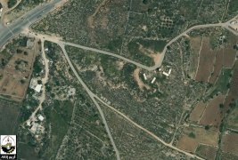
The illegal settlement outpost “Avigal” was established in December 2001. It is located between Maon and Susiya settlements, in the southern part of Hebron Governorate. Nowadays, Avigal outpost has 19 structures (two of them are permanent houses) and is inhabited by 30 Israeli settlers. Note that the structures of Avigal outpost were constructed on land classified by Israel as “State land” [2]. See Map 1
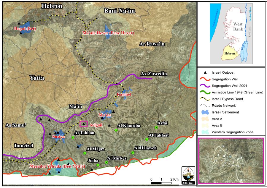
Map 1: the location of Avigal settlement outpost
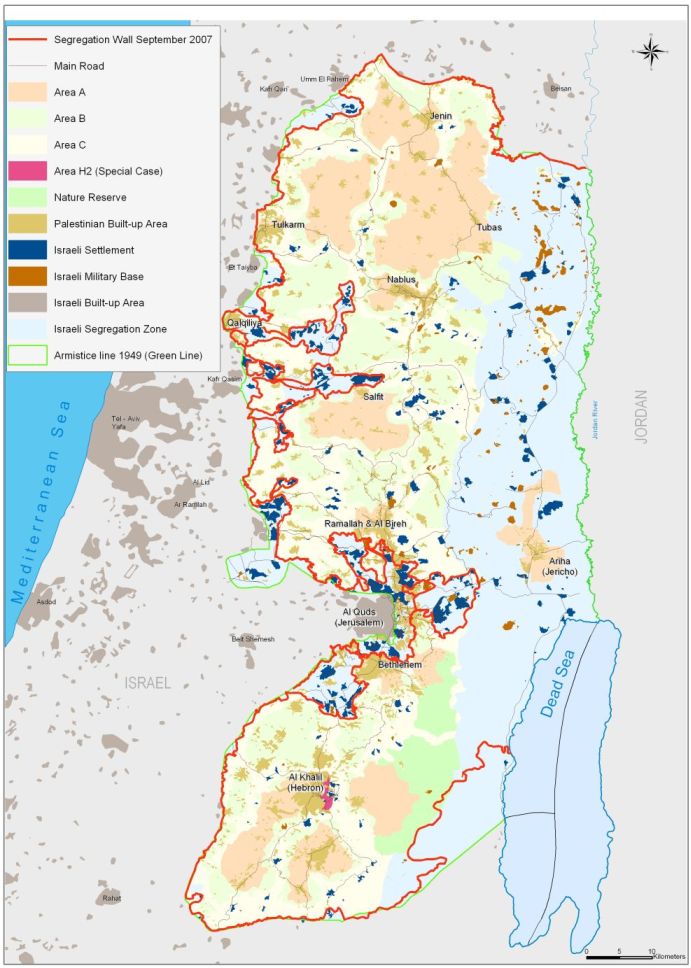
Avigal outpost is part of a chain of illegal Israeli settlements and outposts in the southern Hebron Hills that have been expanding over the years of the Israeli Occupation to form a bloc of settlements which include the following: Karmel, Susiya, Maon and Beit Yattir settlements in addition to Havat Lassfer, Mitzpeh Yair and Havat Maon settlement outposts. The combined area (current urban area) of the aforementioned settlements and outposts is around 4,000 dunums while the master plans [3] of these settlements, which were issued by the Israeli Civil Administration back in 1991, showed that Israel has designated areas for future expansion for these settlements at 10,077 dunums, two and a half times larger than their current size.
The fact that Avigal outpost is not included in any of the master plans of the Israeli settlements surrounding it, has made it of great importance to Israel to take the step of changing the status of the outpost to a legal one, since the outpost completes the ring of settlement in the area and therefore, the legalization of the outpost comes to fulfill the geographical gap.
Furthermore, the legalization of Avigal outpost and the formation of the bloc is part of a larger Israeli plan in the area which aims at annexing more than 30,000 dunums of Palestinian land to “Israel”. These 30,000 dunums are classified by Israel as “Firing Zone” [4]. The area is home to approximately 1,300 people and is comprised of 12 Palestinian communities, they are: Tuba, Mufaqara, Sfai, Majaz, Tabban, Fakheit, Megheir Al-Abeid, Halaweh, Mirkez, Jinba, Khallet Al-Dab’a and Sarura. In July 2012, the Israeli late “defense” minister Ehud Barack order to evacuate eight out of twelve villages located in the Firing Zone area, with around 1,000 residents living in them, to make way for an Israeli training Zone. The threatened communities are: Asfai, Al-Fakheit, Al-Halaweh, Al-Kharuba, At-Tabban, Al-Majaz, Al-Mirjaz and Jinba villages. The Minister’s decision didn’t stop at that far, but the evacuation of these communities will cause the annexation of the whole area to Israel.
One step towards establishing a new Settlement bloc. in the southern Hebron Hills
Following the 1967 Israeli Army occupation of the Gaza strip and the West Bank including east Jerusalem, the Israeli Authorities embarked on constructing Israeli settlements on Palestinian lands in an attempt to consolidate its illegal control over the Palestinian land. Over the years of occupation, Israel has succeeded in clustering the settlements into the form of blocs, meaning, establishing settlements in relatively close geographical areas. This, in turn, has led to the formation of five main Israeli settlement blocs in the occupied West Bank, they are, Ariel-Kedumim settlement block, Modi’in Illit settlement bloc, Giv’at Ze’ev settlement bloc, Ma’ale Adumim settlement Bloc, and Gush Etzion Settlement bloc. These blocs played a very crucial role in the Palestinian-Israeli conflict, and Israel always [5] sought to annex them to its borders to remain under its control under any peace agreement with the Palestinians due to what these blocs have come, over the years, to constitute a geographical, ideological and demographical importance to Israel. Additionally, the construction of the Israeli Segregation Wall has facilitated the annexation of these blocs where it delineated the wall route in a way to affirm the definition of these blocs and eventually annex areas of great importance to Israel in all terms.
By and large, Israel is trying to increase the number of settlements it annexes to its illegal borders and establish a new settlement bloc in the area, first by legalizing Avigal outpost, and second, by filling in the geographical gap in the southern Hebron Hills and linking this outpost with the nearby Israeli settlements and outposts in the east and southwest. Additionally, the location of Avigal outpost in the firing zone area and surrounded by four major settlements (Ma’on, Susiya, Beit Yattir and Karmel) and 10 outposts gives the outpost the advantage to expand and become a settlement in the future; at the same time, gives the Israeli Authorities the motive to annex the area and add it to the list of settlement blocs it is planning to annex through the construction of the wall, and before reaching a final agreement with the Palestinian that would require Israel to give up settlements in the West Bank in return for Peace.
The Israeli Segregation Wall plan
In the year 2002, the Israeli Authorities commenced the construction of the Segregation wall in the occupied Palestinian land in the West Bank area. Since its establishment, the Israeli Authorities made several changes to the route of the wall. However, these changes were made in favor of Israeli settlements in the West Bank as Israel made tremendous efforts to annex as many settlements as possible to its borders.
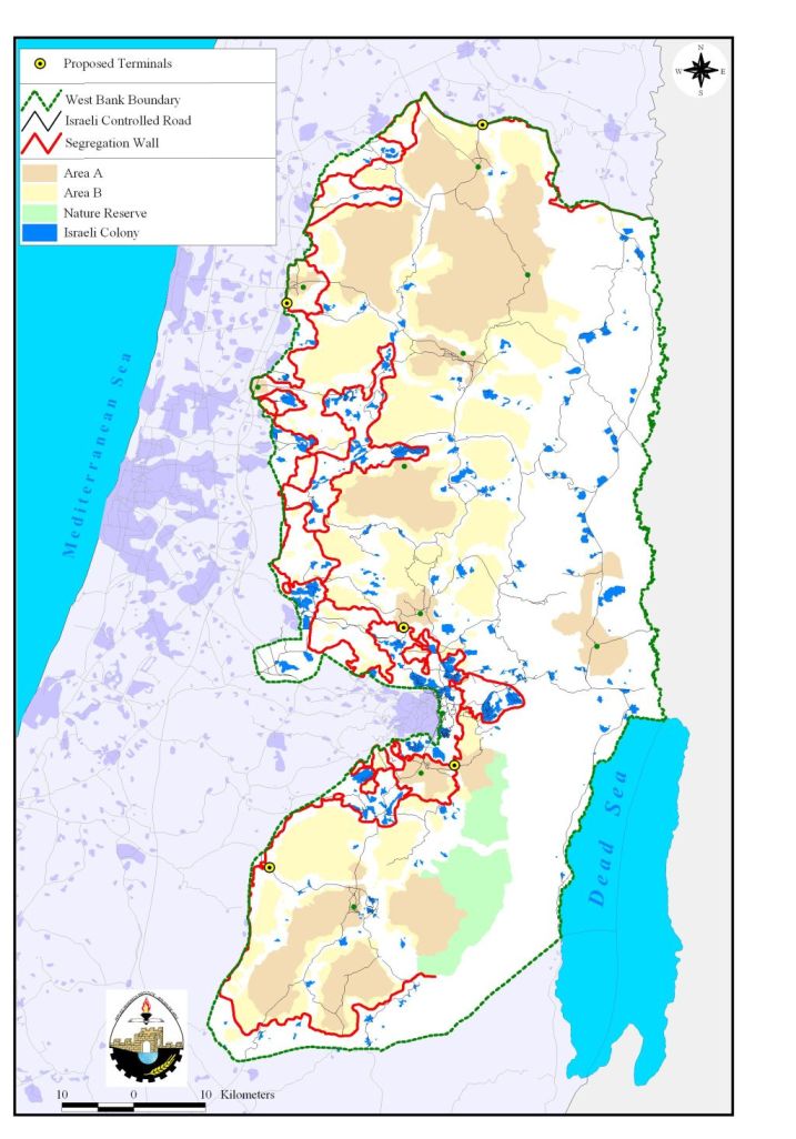
The wall route of 2004 showed that the Israeli Authorities planned to annex thousands of dunums of Palestinian land in the southeastern part of Hebron governorate, which included 9 Israeli settlements (including Ma’on, Susiya, Mitzpe Yattir and Karmel) and 12 illegal outposts (including Avigal outpost), in addition to more than 30 Palestinian communities, to “Israel’s border” (See Map 1). Avigal outpost was among the outposts Israel planned that time to annex through the construction of the wall. In April 2007, the Israeli Ministry of Defense published a revised route of the Segregation Wall which stated a change in the wall route in some areas in the occupied West Bank including the southern Hebron Hills area. The change in wall route of 2007 included supplanting the wall line near the 1967 border, where only three settlements (Sensanah, Negohot and Shima) were included in the western segregation zone [6] additionally, the same targeted area, which includes the 12 Palestinian communities, was set outside the area Israel is set to annex upon wall completion. However, with Israel’s decision to legalize Avigal outpost, and the hopes built on that decision to form a settlement bloc in the area, it appears that this is an initial step towards looting more Palestinian lands by returning the Wall route of 2004 to include the same targeted area, which, at the end, Israel will annex more than 100,000 dunums (100 km2) of lands. See Map 2 & Map 3

Map 2: The Segegation Wal map of 2004
Map 3: The Segregation Wall Map of 2007
To conclude:
Israel has dramatically accelerated its settlement program over the last years in blatant violations of international law. Additionally, Israel's settlements and the Segregation Wall are squeezing the growing Palestinian population into ever smaller enclaves and ghettos and creating the conditions for continued enmity and conflict in the region. Thus, by forcing facts on the ground and manipulating the geographic and demographic balance of the occupied territory, Israel is destroying any possibility of fruitful negotiations to reach a peace agreement based on a two-state solution, with Jerusalem as the capital of both states. Israel’s settlement program is strictly forbidden by the various International Laws and Conventions, some of which are listed below,
- The Fourth Geneva Convention of 1949, Article 49, and paragraph 6 of which states: 'The occupying power shall not deport or transfer parts of its own population into the territories it occupies.' Article 53 of the Convention also prohibits 'any destruction by the Occupying Power of real or personal property belonging individually or collectively to private persons, or to the State, or to other public authorities, or to social or cooperative organizations, is prohibited, except where such destruction is rendered absolutely necessary by military operations.'
- The Hague Regulations of 1907, Article 23 of which prohibits the destruction or seizure of occupied property, unless it is imperatively demanded by military necessity.
- United Nations Security Council Resolution 242 (1967) which requires Israeli armed forces to withdraw from 'the territories occupied' in the 1967 war, including the West Bank and Gaza Strip.
- United Nations Security Council Resolution 452 (1979) which calls upon 'the Government and people of Israel to cease, on an urgent basis, the establishment, construction and planning of settlements in the Arab territories occupied since 1967, including Jerusalem.'
- United Nations Security Council Resolution 465 (1980) which 'Determines that all measures taken by Israel to change the physical character, demographic composition, institutional structure of status of the Palestinian and other Arab territories occupied since 1967, including Jerusalem, or any part thereof, have no legal validity and that Israel's policy and practices of setting parts of its population and new Immigrants in those territories constitute a flagrant violation of the fourth Geneva convention relative to the protection of civilian persons in time of war and also constitute a serious obstruction to achieving a comprehensive, just and lasting peace in the Middle East.'
[1] For more information about Outposts, please check the following article
Netanyahu’s infamous growing Legacy of Housing Units construction in Israeli settlements in the occupied State of Palestine.
https://poica.org/editor/case_studies/view.php?recordID=6039
[2] Israel to Activate "Absentee Property Law" to Steal Palestinian Lands in Occupied East Jerusalem
https://poica.org/editor/case_studies/view.php?recordID=479
[3] In 1991, the Israeli civil administration (ICA) operating in the occupied West Bank (oWB) designated master plans for Israeli settlements spread throughout the oWB, taking into consideration the allocation of additional land for the establishment of new settlements in the future and the expansion of the existing ones. The master plans issued by the ICA in 1991 stood at 486.137 dunums of land (486.1 km², 8.6% of the total area of the WB), which is seven times the size of Israeli settlements area existed until the year 1991, which stood at 69,000 dunums (69 km², 1.2% of the total area of the WB) of land.
[4] This is according to Israeli military order number 271 of 1968 Military Order No. 271 which was issued on August 12, 1968
40 Years of Israeli Occupation
http://www.arij.org/atlas40/chapters.html
[5] in the event of any peace agreement
[6] It is the area Israel to annex upon wall completion, between the 1949 Armistice Line and the route of the wall.
Prepared By
The Applied Research Institute – Jerusalem
ARIJ


