“Where should we go after the last frontiers? Where should the birds fly after the last sky?”[1]… The remarkable words of the late Palestinian poet, Mahmoud Darwish, are still being chanted among all the Palestinians who suffer on a daily basis from the Israeli practices which include home demolitions, expulsion and displacement without any sympathy, humanity or respite.
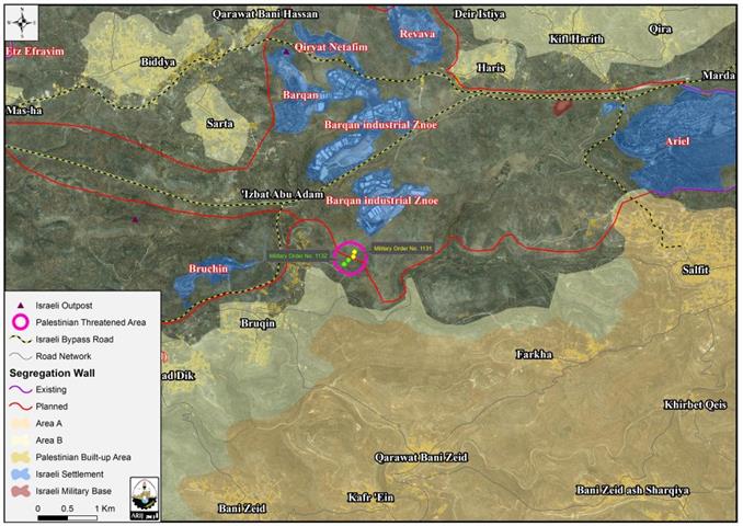
On the 22nd of May, 2013, The Israeli authorities escorted by the Israeli Occupation Army (IOA) stormed the village of Bruqin, in Salfit Governorate, and handed over two Palestinians eviction orders under the pretext that their lands are located in what Israel classifies as ‘State Lands’. The two orders hold No. (1131) and No. (1132); the first order (1131) states the confiscation of 9 dunums of lands, while the second order (1132) states the confiscation of 14 dunums of lands. The targeted plots belong to: Nafiz Ahmad Abd Al Hadi Barakat and Salah Odeh Amer families. See Map 1
 |
Note that the targeted Palestinian lands in the village of Bruqin were declared by the Israeli Authorities as a ‘Sate lands’ according to the Israeli military order No. (59)[2] of 1967 [3]. This order establishes the Israeli Military–appointed position of "Custodian of State Property" to take over land that was owned by the Jordanian Government. The order also allows the "Custodian of State Property" to appropriate land from individuals or groups by declaring it "Public Land" or "State Land", the latter which it defines as land that was owned or managed by, or had a partner who was an enemy body or citizen of an enemy country during the 1967 war.
Analysis of the Military Orders
An analysis conducted by the Applied Research Institute – Jerusalem (ARIJ) indicates that the targeted Palestinian lands are located in the area that will witness the construction of the wall in the near future according to the Israeli maps issued by the Israeli Defense Ministry and to the north of Barqan Industrial zone settlement.
No matter what method Israel uses, it clearly works under one and only systematic approach, which is ‘to confiscate Palestinian lands for the favor of expanding its illegal settlements’ in the occupied West Bank. The segregation wall is also one of the methods Israel used since 2002 (after the second Intifada) to confiscate more Palestinian lands under the various “security” pretexts. However, the consequences of constructing the wall over Bruqin village lands will be devastating as it will run a length of 14.2 km on lands of Bruqin village from 3 directions; north, east and west and Upon completion, the wall will cause the confiscation and Isolation 2457 dunums of Bruqin lands (20% of the total village area) to become part of the Western Segregation Zone which eventually Israel will annex to its proper.
Bruqin village, general glance
A Palestinian village located in Salfit Governorate. It’s bounded by Farkha village from the East, Kafr Ein and Bani Zaid from the south, Kafr Ad dik from the West and the Israeli Segregation wall and the Israeli settlement of Bruchin from the north.
The geopolitical status of Bruqin
According to the Oslo II interim agreement of 1995 which was signed between the Palestinian National Authority and Israel, Bruqin village lands were divided into Areas ‘A’, ‘B’ and ‘C’. Approximately 1,034 dunums (8.4% of the total village area) were classified as area ‘A’, where the PNA has the full control over security and administrative matters. Meanwhile, 4,398 dunums (35.8% of the total village area) were classified as area ‘B’, where the PNA retains the control over administrative matters and Israel has the full control over security matters. The remaining area of the village (6,583 dunums), which constitutes 55.8% of the total village area were classified as area ‘C’ where the security and administrative issues are subjected to the Israeli full control. Note that Palestinians living in Area ‘C’ are forbidden from building and land management/utilization unless a permission from the Israeli Civil Administration is granted, which is most of the time hard to obtain. [5] See table (1):
|
Table 1: The geopolitical status of Bruqin village according to Oslo II interim agreement in 1995
|
||
|
Area
|
Area in dunums
|
Percent of total town area
|
|
Area A
|
1,043
|
8.4%
|
|
Area B
|
4,398
|
35.8%
|
|
Area C
|
6,853
|
55.8%
|
|
Total
|
12,285
|
100%
|
|
Source: ARIJ-GIS Unit, 2011
|
||
The Impact of the Israeli occupation on Burqin Village
Since the Israeli occupation of the West Bank in 1967, thousands of dunums have been expropriated from Bruqin village for the favor of the Israeli colonial enterprises in that area; building settlements, outposts, and military bases, constructing bypass roads, erecting checkpoints, and preparing for the construction of the Israeli segregation wall. Today, two illegal Israeli settlements are occupying Bruqin village lands and confiscate a total of 585 dunums (5% of the total village area). The two settlements are identified as: Bruchin and the Industrial zone of Barqan. More information about these settlements is listed in table (1):
|
Table 2: The illegal Israeli settlements established on Bruqin lands
|
|||
|
Settlement name
|
Year of Establishment
|
Lands confiscated in dunums
|
Settlers population (2011)
|
|
Bruchin
|
1999
|
332
|
540
|
|
The Industrial zone Barqan
|
1981
|
253
|
Industrial zone
|
|
Total
|
585
|
540
|
|
|
Source: the Geo-Informatics Department , ARIJ, 2012
|
|||
After the eruption of the second intifada in September, 2000, Israel erected 2 cement checkpoints to cut any link between the village and the Israeli bypass road No. 446 [6], allegedly, to protect the Israeli settlers from the Palestinian residents. In fact, these checkpoints were erected to impose rigid constrains on the Palestinians of Bruqin to obstruct their entry and exit to and from their own village.
Moreover, the Israeli settlers, certainly with the approval of the Israeli government, seized hundreds of dunums of Bruqin village lands to establish their illegal outpost to the northeast of Bruchin settlement.. By doing so, they ensure that more lands will be confiscated from Bruqin village in the near future for the favor of expanding this outpost and later annexing it to the adjacent ‘mother’ settlement, Bruchin.
To conclude
Israel kills every possible chance for the establishment of a genuine and viable Palestinian state in the future. The Israeli systematic attacks against the Palestinians and their properties constitute a grave breach of the international law rules and conventions, some of which are listed below:
- Article 53 & 147 of the Fourth Geneva Convention of 1949 indicated that: Extensive destruction and appropriation of property not justified by military necessity and carried out unlawfully and wantonly, is a grave breach of the Convention.
- Art. 23 of the Hague Convention of 1907 also provides: In addition to the prohibitions provided by special Conventions, it is especially forbidden to destroy or seize the enemy’s property, unless such destruction or seizure be imperatively demanded by the necessities of war.
- ‘Article 12’ of the International Covenant on Civil and Political Rights Everyone lawfully within the territory of a State shall, within that territory, have the right to liberty of movement and freedom to choose his residence
[1] The Earth is closing on us, Mahmoud Darwish:
[3]Foundations of civil and political rights in Israel and the occupied territories, Page 362
[4] ISRAELI MILITARY OPPRESSION AND EXPLOITATION OF PALESTINIAN SOCIETY IN GAZA AND THE WEST BANK: HOW IT WORKS
[5]The Israeli policies in area (C): "Silent transfer of the Palestinian Population
[6]The Israel bypass road No. 446 was opened after the confiscation of thousands of dunums from Bruqin village in order to connect the illegal settlement of Bruchin with the surrounding settlements and outposts.


