Since the occupation of the Palestinian territory in 1967, the successive Israeli governments invested substantial resources in establishing and expanding the Illegal settlements in the occupied Palestinian Territory (oPt), both in terms of the land area they occupy by expropriating as much as possible of Palestinian land, and in terms of population. As a result of this policy, more than 656,000 illegal Israeli settlers now live in 196 settlements, including tourist settlements, and 232 outposts distributed all over the West Bank, including East Jerusalem, all built in contradiction to the international law.
In 1991, the Israeli civil administration (ICA) operating in the occupied West Bank (oWB) designated master plans for Israeli settlements spread throughout the oWB, taking into consideration the allocation of additional land for the establishment of new settlements in the future and the expansion of the existing ones [1]. The master plans issued by the ICA in 1991 stood at 486.137 dunums of land (486.1 km², 8.6% of the total area of the WB), which is seven times the size of Israeli settlements area existed until the year 1991 which stood at 69,000 dunums (69 km², 1.2% of the total area of the WB) of land.
And following the signing of the Oslo Accords, I and II, in 1993 and 1995 respectively and the classification of the Palestinian lands into areas, “A”[2], “B”[3] and “C”[4], the Israeli Occupation Authorities ignored the designation of Master plans for Palestinian communities in area “C” to meet their (Palestinians’) urban needs as it did with settlements, and did not take into account the status on the ground with regard to Palestinian constructions at these communities. Consequently, these communities stayed under the threat of demolition for lack of ability to issue building permits which avoid them demolition and displacement; this was due to the imposition of harsh measures by the Israeli Authorities on Palestinians acquiring building permits, and the long and complicated procedures that Palestinians have to go through to get a building license that enables them to build on their land or exploit it for any purpose whatsoever. Palestinians’ applications for building are most of the times rejected by the Israeli Authorities under the claim of “not meeting the necessary conditions needed for building in area “C”.”[5]
A report Published by Israeli daily newspaper (Haaretz) on the 27th of May 2013 indicates that the Israeli settlements jurisdiction area in the occupied West Bank increased by 7375 dunums (7.4 km²) in the year 2012 to stand at 538,303 dunums (538.3 km²) by the end of 2012 after it was 530,931 dunums (531 km²). It should be noted that that the Israeli settlements jurisdiction area exceeds that of the Israeli settlements master plan area of 1991. The increase was, as reported by the newspaper, as a result of Israeli military orders that have been issued and ratified during the year 2012 and granted Israeli settlements’ councils in the West Bank control over new Palestinian land for settlement expansion, that is in addition to the area which is already occupied by existing Israeli settlements and the area that comes under the Israeli settlements master plans. In fact, this increase has not been limited to the year 2012, because during the years of 1991 and 2011, the Israeli occupation authorities issued several military orders, that have not been made public, to confiscate more Palestinian land for security purposes and other flimsy pretexts. These orders increased the Israeli settlements jurisdiction area to 530931 dunums (531 km²) by the end of the year 2011, an increase of 44,794 dunums (44.8 km2) of the Israeli settlements’ master plan area of 1991 (486.137 dunums (486.1 km²).
An Analysis conducted by the applied research Institute — Jerusalem (ARIJ) of the Palestinian land that was confiscated through military orders to become part of the Israeli settlements jurisdiction area showed that 1.19% of the total settlements jurisdiction area falls within the area classified as "A" according to the Oslo II accords of 1995; the analysis also showed that 1.86% of the total settlements jurisdiction area falls within the area classified as "B" according to OSLO II accords of 1995; while the remaining area, which constitutes 90.8% of the total settlements jurisdiction area is located in the area classified as "C", including those classified by Israel as "State land" [6], closed military areas [7], mined areas and “Nature Reserves”[8]. Table 1 and Map 1 is a breakdown of the settlements jurisdiction area classifications:-
|
Table 1: classification of the Israeli settlements jurisdiction area
|
||||||
|
No.
|
Classification of the Israeli settlements jurisdiction area
|
% of the total Israeli settlements jurisdiction area
|
Area
(in Dunums) |
|||
|
1
|
Area “A”
|
1.19%
|
6400
|
|||
|
2
|
Area “B”
|
1.86%
|
10000
|
|||
|
3
|
Area “C”
|
98.44%
|
521903
|
|||
|
Total
|
100
|
538303
|
||||
|
Classification of the Israeli settlements jurisdiction area classified as “C”
|
||||||
|
Overlapped areas
|
No.
|
Classification of area “C”
|
Area
(in dunums) |
% of total “C” area
|
||
|
1
|
Closed military zone
|
292780
|
54.39%
|
|||
|
2
|
State Land
|
400256
|
74.36%
|
|||
|
3
|
Nature Reserves
|
94845
|
17.62%
|
|||
|
4
|
Mined Areas
|
4875
|
0.91%
|
|||
|
Source: The Geo-informatics Department, ARIJ 2013
|
||||||
 |
Among most affected Palestinian Governorates of the Israeli plans that aim at confiscating more Palestinian land for the sake of Israeli settlements are Jericho Governorate in the Jordan Valley, Jerusalem Governorate in the central West Bank, and the Governorates of Bethlehem and Hebron in the southern West Bank. See Chart 1
|
Below are some examples of Israeli settlements that will witness expansion as stipulated in the Israeli military orders issued during the year 2012:
- Geva’ot settlement located within the Gush Etzion settlement bloc. In Bethlehem Governorate: the settlement occupies a total land area of 135 dunums that were confiscated from Nahhalin village lands. According to the Israeli settlements’ master plans published in the year 1991, the area of Geva’ot settlement master plan is 530 dunums, nearly four times the current area of the settlement. Additionally, the Israeli military orders issued during the year 2012, increased the jurisdiction area of the settlement by about five times (2,560 dunums) the area of Geva’ot settlement master plan.
- Avnei Hefetz settlement in Tulkarem Governorate: the settlement occupies a total land area of 1392 dunums that were confiscated from kafr Al Labad and Shofa lands. According to Israeli settlements’ master plans published in 1991, the area of Avnei Hefetz settlement master plan is 1731 dunums, more than double the current settlement area. Additionally, the Israeli military orders issued during the year 2012, increased the jurisdiction area of the settlement nearly double the area (3530 dunums) of Avnei Hefetz settlement master plan.
- Na’omi settlement in Jericho Governorate: the settlement occupies a total land area of 4940 dunums that were confiscated from Al Auja and An Nuweima villages. According to Israeli settlements’ master plans published in 1991, the area of Na’omi settlement master plan is 5686 dunums, more than double the area of the settlement today. Additionally, the Israeli military orders issued in the year 2012, increased the jurisdiction area of the settlement more than double the area (6045 dunums) of Na’omi settlement master plan.
- Gittit settlements in Nablus Governorate: the settlement occupies a total land area of 1058 dunums that were confiscated from Aqraba and Majdal Bani Fadel villages. According to Israeli settlements’ master plans published in 1991, the area of Gittit settlement master plan is 2945 dunums, nearly three times the current area of the settlement. Additionally, the Israeli military orders issued in the year 2012, increased the jurisdiction area of the settlement nearly double the area (3439 dunums) of Gittit settlement master plan.
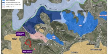
- Shdemot Mehola and Rotem settlements in Tubas Governorates: The two settlements occupy a total land area of 1341 dunums (1290 dunums and 51 dunums respectively) of Tubas city lands. According to Israeli settlements’ master plans published in 1991, the area of Shdemot Mehola and Rotem settlements master plan is 4313 dunums, nearly three times the current area of the two settlements. Additionally, the Israeli military orders issued in the year 2012, increased the jurisdiction area of the two settlements more than the double area (4960 dunums) of Shedmot Mehola and Rotem settlements master plan area. See Map 2

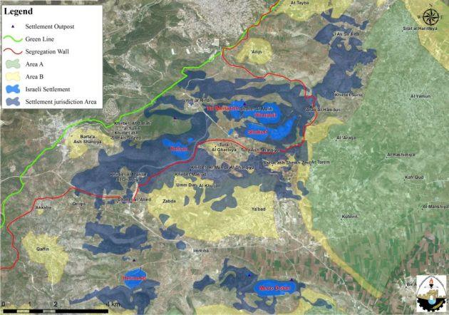
Of the special cases noted in the analysis was the Shakid settlements’ bloc (Shaked, Rehan, Hinanit and Tel Menashe) west of Jenin city and located inside the Barta’a enclave. The settlements’ jurisdiction area extends beyond the Israeli segregation wall path, on the eastern side of the wall, at the expense of Palestinian land classified as “A” and “B”. See Map 3
|
|
Map 3: Shakid Settlement Bloc.
Table 3 gives details of the settlements jurisdiction areas as stated in the Israeli military orders:-
|
Table 3: the Israeli settlements jurisdiction areas as stated in the Israeli military orders:-
|
|||||
|
Number
|
Settlement Name
|
Current settlement area (dunums)
|
Israeli settlement Master plan of 1991 (in dunums)
(Acre)
|
Israeli settlement jurisdiction area (in dunums)
|
(%) of increase from Israeli master plans of 1991
|
|
1
|
Geva’ot-Bethlehem
|
135
|
530
|
2560
|
483
|
|
2
|
Shaked Group (Shaked, Rehan, Hinanit and Tel menashi)-Jenin
|
|
12700
|
23640
|
186
|
|
3
|
Avnei Hefetz-Tulkarm
|
1392
|
1731
|
3530
|
204
|
|
4
|
Nofim – Yakir, Salfit
|
1301
|
2370
|
24237
|
323
|
|
5
|
Naomi-Jericho
|
4940
|
5686
|
6045
|
106
|
|
6
|
Gittit – Nablus
|
1058
|
2945
|
3439
|
117
|
|
7
|
Shedmot Mehola- Rotem, Tubas
|
1341
|
4313
|
4960
|
115
|
|
Source: The Geo-Informatics Department, ARIJ 2013
|
|||||
To Conclude,
For Israel to become a credible peace partner, it is required first that it stops settlement building and expansion in the oPt. A search of the past thus far indicates that neither commitment nor credibility from Israel’s side has been adequately forced on the ground. This is because of the many unilateral actions and intangible steps that Israel took to make the concept of a viable Palestinian state difficult to reach in concrete manner. Whether Israel is successful in surviving with its unilateral plans in the oPt as a discrete fact on the ground, or continues to impose its bitter and painful realities on the ground, the notions of both its illegitimate settlement construction and incredibility as a peace partner will continue to exist.
[1] Those settlements which exited until the year 1991, when the Israeli Civil Administration published the master plans.
[2] In Area A, the Palestinian National Authority (PNA) holds all responsibilities for internal security and Public order
[3] In Area B: the Palestinian National Authority (PNA) has complete control over civil matters but Israel continues to have overriding responsibility for security
[4] In area C, The PNA has responsibility for civil life such as Economics, health, and education; while, Israel retains full control over security and administration related to the territory.
[5] The Israeli policies in area (C): "Silent transfer of the Palestinian Population
[6] Israeli Military Orders allowing the Israeli Civil Administration to Confiscate Privately Owned Land & Property: Israeli Military Order #59 (1967?) – establishes the Israeli Military-appointed position of ‘Custodian of Government Property’ to take control of land owned by the Jordanian Government. Also, allows the ‘Custodian of Absentee Property’ to appropriate land from individuals or groups by declaring it ‘Public Land’ or ‘State Land’, the latter defines as land that was owned or managed by, or had a partner who was an enemy body or citizen of an enemy country during or after the 1967 war (amended by M.O.1091).
[7] Declaration of Occupied Land as "Closed Areas": Military Order No. 378, 1970: According to Article 90 of Military Order No. 378, 1970150 any "military commander" (i.e. any officer) is empowered to declare by a written order any area or place as a "closed area" for the purpose of the above order. The ownership of closed areas remains in the hands of the residents, but they are deprived from their right of use of the land without any compensation.
[8] Nature Reserves in light of the Israeli assaults !!!