Israel continues its attacks against Palestinian lands and properties in the West Bank without any respite. During the month of March 2013, Hebron governorate witnessed numerous attacks by the Israeli occupation, varied from land confiscation and eviction to home demolitions and other attacks. Below are some of the major attacks that took place during March:
On the 15th of March, 2013, the Israeli occupation authorities handed out military orders to demolish a number of Solar cells (panels) in Mughor Al Abed area in Massafer Yatta.
On the 17th of March, 2013, the Israeli occupation Army (IOA) demolished a Palestinian tent in Khirbet Um Tuba in Yatta town. The targeted tent was used by residents of the area as a classroom for the only local school in the Area.
Kherbit Mughor Al Abed & Kherbit Um Tuba
kherbits of Mughor Al Abed & Um Tuba are located in the southern Hebron hills, within Yatta town, in the area classified as ‘C’[1] according to Oslo II Interim agreement of 1995. The two Kherbits (hamlets) are surrounded from north and northwest with a number of Israeli settlements (Karmi’el, Maon and Avigal, north and northwest respectively) and outposts (Hill 833 and Maon old farm) which have been limiting the urban expansion of the two aforementioned Palestinian communities throughout the previous years.
Note that the Israeli Occupation Authorities considers the area where kherbits of Mughor Al Abed, Um Tuba and other nearby kherbits are located, as closed military zone (Firing Zone 918) and so, the existence of these communities in such a strategic place (according to Israel’s classification) threatens the security of settlements and outposts in the area and thereby, are considered illegal and must be evicted.
General glance of the Israeli occupation practices in Yatta town
Since Israel occupied the West Bank including East Jerusalem and the Gaza Strip in 1967, it rushed to impose unilateral facts in the Palestinian territory through the systematic confiscation and annexation of lands for the various Israeli settlement purposes. Yatta town was one of the many Palestinian communities to witness such a colonial enterprise.
Moreover, Israel has fostered its acquisition of Palestinian lands through the erection of illegal settlements and outposts to increase settlers’ population in the Palestinian territory to reinforce its occupation of the land. Additionally, Israel has constructed bypass roads (only for explicit settlers’ use) to create a geographical contiguity between illegal Israeli settlements and outposts to ease settlers’ movement.
Israeli settlements on lands of Yatta town
Throughout the years of Israeli occupation, Yatta town has witnessed the construction of five illegal Israeli settlements on its lands, they are: Karmi’el settlement, Ma’on settlement, Susiya settlement, Otni’el settlement and Mezadot Yehuda settlement. These five settlements occupy today a total land area of 3,526 dunums of Palestinian lands (ARIJ, 2013) and are populated with more than 3,000 Israeli settlers (ARIJ, 2013). Table 1 gives more information about the settlements which were illegally established on lands of yatta town:
Table1: The Israeli settlements confiscating Yatta town Lands | |||
Settlement Name | Establishment date | Lands confiscated from Palestinians (dunums) | Settlers population 2011 |
Karmi’el | 1981 | 376 | 322 |
Ma’on | 1980 | 735 | 418 |
Susiya | 1983 | 1.040 | 971 |
Mezadot Yehuda | 1977 | 690 | 522 |
Otni’el | 1983 | 685 | 893 |
Total | 3526 | 3126 | |
Source: Applied Research Institute – Jerusalem (ARIJ) | |||
Previous Israeli violations in Yatta town
On the 9th of February, 2013, the Israeli occupation army (IOA) raided and destroyed Canaan protest village [2] which was constructed on Yatta town lands by Palestinians of Yatta town and other foreign activists in response to the Israeli occupation practices to confiscate Palestinian lands and use them for colonial projects. Not only has (IOA) tore down Canaan village tents, but also attacked all who participated in constructing the village and detained them.
Israeli Evacuation orders targeting lands of Beit Ula Town
The Israeli colonial attacks have also targeted Beit Ula town, west of Hebron city. Some of which are listed below:
On the 12th of March, 2013, the Israeli Occupation Authorities handed out Palestinians of Khallet Ad Diyab and Khallet Atous in Beit Ula town west of Hebron city military orders to evacuate their lands. The targeted lands are owned by Al Amleh family.
On the 14th of March, 2013, the Israeli Occupation Authorities handed out military orders to evacuate 245 dunums of agricultural lands and demolish three water wells in Atous and Wad Al Najjar areas in Beit Ula town west of Hebron city under the claim that the lands are classified as “State lands”. The targeted lands are owned by: Mohammad Odeh Al-Amlih, Husni Hamid Al-Amlih, Mohammad Abd Al-Aziz Al Amlih, Mohammad Khalil Al-Amlih, Waleed Abd Al-Aziz Al-Amlih, Mohmoud Khalil Abd Al-Aziz Al-Amlih, and Abd Al Fatah Nasir Al-Amlih. See Map 1
 |
 | |
| |
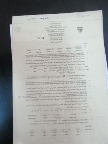
Photo 1-4: copies of the militray orders
Beit Ula Town, general glance:
Beit Ula is located 12 km to the northwest of Hebron city. It’s bounded by Kharsa and Nuba towns from the north, Tarqumiya town from the south, Halhul town from the east, and Ras Al Joura area and Jamrora Hamlet from the west. The town is surrounded by numerous Palestinian towns and villages in which it depends on in all aspects of life.
Beit Ula has a total area of 22,432 dunums (ARIJ, 2013), and houses a total population of 13,000 Palestinians (PCBS, 2011).
Previous Israeli evacuation orders targeting lands of Beit Ula Town
It is not the first time that Beit Ula town is targeted with such military orders, where during the last couple of years, many orders were issued targeting tens of dunums of lands of beit Ula conducted under the pretext of ‘State lands’. Some of which are listed below:-
On the 12 of September 2011, the Israeli Civil Administration handed out Palestinians of Atous and Mekhath areas in Beit Ula town west of Hebron city military orders to evacuate 59.5 dunums of lands under the pretext of being classified as ‘State Land’. The distributed orders held numbers 616, 617, 618, 619, 620, 621, 622, 623 and 624.
On February 6, 2012, the Israeli Civil Administration handed out Palestinians of Khallet Ad Deib in Beit Ula town west of Hebron city military orders to evacuate three parcels of land (30.2 dunums) under the pretext of being classified as ‘State Land’.
On the 12th of October 2012, the Israeli Civil Administration handed out Palestinians of Deir Ebn Ubeid, Wadi Al Ruqati and Khallet Alqam military order s to evacuate 70 dunums of lands under the pretext of being classified as ‘State Land’. The distributed orders held numbers 1057, 1052, 1056, 1045 and 1061,
Impact of the Israeli occupation on Beit Ula town
Palestinians of Beit Ula as many Palestinians of other towns & villages in the West Bank have always witnessed the never-ending Israeli colonization activities in the town, as orders of further land confiscation for the various Israeli purposes were distributed, affecting the very aspect of life, their source of living .
The construction of the Israeli segregation wall which was sanctioned[3] in 2002 has also confiscated approximately 1,500 dunums of Beit Ula lands. These 1,500 dunums were isolated west of the wall and landowners aren’t permitted to access their lands unless a previous coordination with the Israeli Civil Administration is made. These lands used to constitute a major source of income for Beit Ula families especially after the eruption of the second Intifada in 2000 and losing their jobs inside Israeli.
Photos 5-10: Targeted lands in Beit Ula
To conclude
The Israeli government always works under a strategic and tactical framework which is ‘how to control and annex as much Palestinian lands as possible’ for colonial activities, to build new settlements and outposts, to construct new bypass roads for the explicit settlers’ use) and to go on with the construction of the segregation wall. These practices are implemented under various pretexts such as declaring lands as ‘State Property’ or ‘closed military zones’ and this is exactly what is happening in Yatta and Beit Ula towns.
The never-ending Israeli colonial practices being implemented in all occupied Palestinian communities prove conclusively that Peace is an option that does not exist in Israel’s agenda. These practices kill any chance for a future and viable Palestinian state. These practices are condemned by international law and all Human rights conventions. Some of which are listed below:
United Nations Security Council, Resolution 446 March 22, 1979 calls on Israel to rescind its previous measures and to desist from taking any action which would result in changing the legal status and geographical nature and materially affecting the demographic composition of the Arab territories occupied since 1967, including Jerusalem and, in particular, not to transfer parts of its own civilian population into the occupied Arab territories’.
Article 49 paragraph 6 in the Fourth Geneva Convention that” The occupying power shall not deport or transfer parts of its own population into the territories it occupies.”
Article 53 & 147 of the Fourth Geneva Convention of 1949 indicated that: Extensive destruction and appropriation of property not justified by military necessity and carried out unlawfully and wantonly, is a grave breach of the Convention.
[1] Area C: according to OSLO II interim agreement of 1995, area C falls under the full Israeli control, Administrative and security.
[2] Canaan Village was the third village constructed on Yatta town lands by Palestinians and other international activists as a response to the Israeli occupation practices to confiscate their lands. The first constructed village was “Bab Al-Shams”. It was constructed on the threatened lands of (Abu Dis, Ezariyeh, Issawiya, Anata, Tur and Az Za’ayim) to achieve an Israeli colonial enterprise known as “E1” Plan. The second Village was “Al-Karameh”, which was constructed on the threatened lands of Beit Iksa north-west of Jerusalem.
[3] The Israeli Government sanctioned the construction of the Segregation Wall in June 2002.


