The Palestinian communities in West Bank are exposed to daily attacks by the Israeli Occupation Army and the Israeli settlers who live in West Bank settlements. A New type of non violent resistance was born in the year 2013 to reject the Israeli Policies that aim at confiscating Palestinian lands and properties in the West Bank. Palestinians established several new villages in the West Bank, on lands either declared as 'confiscated' or threatened of confiscation by the Israeli Authorities to expand Israeli settlements, outposts, build the Segregation wall and construct Israeli Bypass roads.
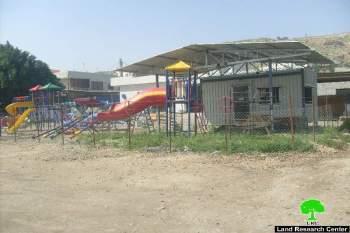
On the 2nd of February 2013, a group of Palestinians established a new village called “Al-Manateer” on lands of Burin village south of Nablus city and set up a number of tents and structures in the area. The new village was established to protest against the Israeli occupation authorities' measures that aim at hindering Palestinians of Burin village from reaching this spot of land for security considerations and preventing Palestinian land owners from utilizing these lands as should, and against the Israeli settlements expansions which are taking place on lands of the village and the constant Israeli settlers' attacks which are costing Palestinian farmers in Burin village a huge loss since they target the agricultural sector in the village which is the main source of livelihood for most Palestinian families.
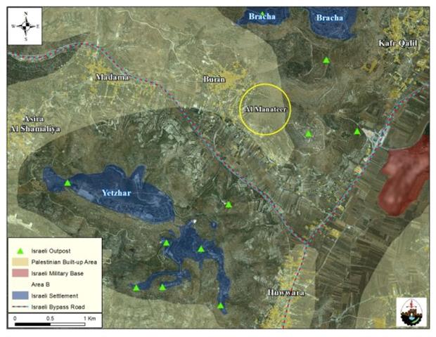
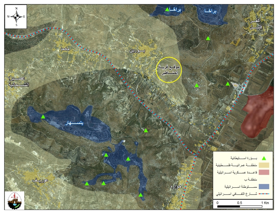
And like the many villages that were established in various areas in the West Bank, Al Manateer village faced the same fate that other villages did since the Israeli Occupation Army (IOA) didn't hesitate the next day (on the 3rd of February 2013) to demolish the newly established village and were accompanied by Israeli settlers of the nearby Israeli outpost, Giv'at Ronen, who also took part in the demolition process. See Map 1
The Israeli Occupation Army (IOA) also arrested many Palestinians who were present at the site to prevent the demolition process, as a result, clashes erupted between Palestinians and the Israeli settlers who fired live bullets and Gas Bombs at Palestinians in an attempt to disperse them and hinder them from resisting the demolition process and evacuated the area by declaring it a 'Closed Military Zone' so that Palestinians won't access it again. Note that the location of Al Manateer Village in Burin is located in the area classified as 'B' area according to OSLO II Interim agreement of 1995 and the Israeli Occupation Army has targeted the area despite the fact that it has no authority to demolish in such areas; additionally, the IOA has declared the location of Al Manateer village as a 'closed Zone' so that it hinders the Palestinian urban expansion in this particular site of the village due to its location close to an Israeli outpost.
An article published by the Israeli daily newspaper Haaretz on the 4th of February 2013, stated that the Israeli Civil Administration informed the Israeli Occupation Army prior to the demolition that the tents and structures comprising 'Al Manateer village' are located in the areas classified as 'B' areas according to the signed agreements and that the IOA is not authorized to operate in this area as it falls under the Palestinian control (the civil affairs)while Israel only controls the security matters. Additionally, an officer of the Israeli Civil Administration who was present at the site declared that the tents of Al Manateer village were established on lands classified as 'B' and only Palestinians are authorized to impose law on illegal structures in such areas, as stated by the newspaper.
The Israeli Occupation Authorities claim that Palestinians of Al Manateer village hurled stones at the Israeli Occupation Army (IOA) and settlers who were present at the site and that the IOA had to demolish the tents and evacuate the area despite of its classification to maintain security. While, on the ground, the location of Al Manateer village has always been a witness at the Israeli settlers' attacks against Palestinians' lands and properties in the previous years and the clashes that took place between Palestinian landowners and the IOA who tried to prevent them from accessing their lands because the lands are close to an Israeli outpost located in the area, named Giv'at Ronen.
Therefore, the Israeli assault on the village of Al Manateer is to promote the confiscation of the land in the area for pure settlement purposes, irrespective of its classification, whether under the control of the Palestinians or the Israelis, as the Israeli overwhelm interest is above everything. The targeted land doesn't constitute, in reality, a security measure for the nearby Israeli outposts and settlements in Burin village, but if settlers and the IOA continue to target it, they will cause the isolation of the lands from their original owners and deny them their rights.
Burin Village
Burin village is located 4.5 kilometers away from the south of Nablus city. It is bordered by Iraq Burin village and Bracha settlement from the north, Yetzhar settlement and the Israeli Bypass road number “60” from the south, Rujeib, Kafr Qalil and Awarta villages and Itamar settlement from the east, Madama and Asira Al Qiblieh villages from the west. The village's total area is 18488 dunums and is inhabited by more than 2500 Palestinian citizens.
The Geopolitical Status of Burin Village
The Oslo II Interim Agreement signed in September 1995 between the Palestinian Liberation Organization (PLO) and Israel, concluded Israel's withdrawal from areas of the West Bank, and that the Occupied Territory be classified into areas “A,” “B” and “C,” designating varying levels of control (see table 1). In Area A, the Palestinian National Authority (PNA) holds all responsibilities for internal security and Public order; while in Area B, the PNA has complete control over civil matters but Israel continues to have overriding responsibility for security. In area C, The PNA has responsibility for civil life such as Economics, health, and education; while, Israel retains full control over security and administration related to the territory.
Accordingly, 525 dunums of Burin village lands (2.8% of the total area of the village) were classified as area “A”; and another 6150 dunums (33.3% of the total area of the village) were classified as area “B”; While the remaining area of the village, 11813 dunums (63.9% of the total area of the village) were classified as area “C”. Note that in Area C, Palestinians are prohibited from building and utilizing lands for any purpose unless they acquire a building permit from the Israeli Civil Administration to do so. Besides, most of the lands which are classified as area “C” in Burin village are agricultural lands and some open areas which are the only space left for Palestinians of Burin village to expand and develop in the future. See Table 1
|
Table 1: The Geopolitical Divisions of Ni'lin Village – Ramallah Governorate |
||
|
Percent of Total village area |
Area in dunums |
Area |
|
2.8 |
525 |
Area A |
|
33.3 |
6150 |
Area B |
|
63.9 |
11813 |
Area C |
|
100 |
0 |
Nature Reserve |
|
100 |
18488 |
Total |
|
Source: Source: The Geo-informatics Department – ARIJ 2011 |
||
The Israeli Colonization Activities in Burin Village
For decades, Israel has resorted to take various measures to confiscate Palestinian owned lands in Burin village for the various Israeli purposes such as settlements and outposts building, bypass road construction, the establishment of military bases and many other military usages under the multiple motives, including religious, political and economic.
During the past years, Burin village has witnessed the loss of 1103 dunums of its lands for the construction of two Israeli settlements, Bracha (established in the year 1982) and Yezhar settlement (established in the year 1983). Today, around 2500 Israeli settlers live in the aforementioned settlements.
|
Table 2: Israeli settlements established on lands of Burin Village |
||||
|
No. |
Settlement Name |
Establishment Date |
Population 2009 |
Area of settlement inside village |
|
1 |
Bracha |
1982 |
1533 |
601 |
|
2 |
Yetzhar |
1983 |
895 |
1260 |
|
Total |
2428 |
1861 |
||
|
Source: The Geo-informatics Department –ARIJ, 2013 |
||||
Israeli outposts established on lands of Burin Village
Burin village also witnessed the seizure of its lands by force by Israeli settlers for the purpose of establishing four Israeli outposts, they are: South Bracha outpost – 'Ein Horon', 'Hill 778' outpost, 'Shelhevet Yitzhar East' outpost and 'Givat Ronen' outpost. These outposts aim expanding existing settlements located near the village and control more lands in the area.
Israeli settlers' attacks on lands and properties in Burin Village
The attacks of Israeli settlers' living in settlements established on lands of Burin village have the greatest impact on Palestinians and their properties in the village. These attacks contributed much to the control of more Palestinian lands adjacent to the already existing settlements through the burning and destruction of Trees and other field crops, prevention of Palestinian farmers from accessing their lands, fencing lands with barbed wires and planting them with trees as to enhance the control over the land. Follow are some of the Israeli settlers attacks that targeted burin village
-
On the 28th of September 2012, a group of Israeli settlers from Yetzhar settlement uprooted 81 Olive trees in Khallet Siwar in Burin village. The targeted trees are owned by Ahmed Abd Al-Fatah Khalifah and his family.
-
On the 12th of July 2012, a number of Israeli settlers from Yetzhar settlement torched 19 dunums of lands planted with 187 olive trees in Habayel Abu Isam’l area in Burin village. The targeted trees are owned by Raf’at Yaseen An-Najar, Fahmi Sa’id Qadous, and Ra’fat Khalid Najar.
-
On the 9th of May 2012, the Israeli settlers from Yetzhar settlement uprooted and damaged 17 olive trees in Khallet Siwar area in Burin village. The partially damaged trees are owned by Abd Al-Kadir As’ad Amran.
-
On the 20th and 24th of May 2012, a group of Israeli settlers from Yetzhar settlement uprooted 71 seedlings in Khallet Siwar area in Burin village. The targeted trees are owned by Akram Ibrahim Ali Amran, Qaseem Abd Al-Aziz Musa Eid, Mahmoud Raja Eid, Hassn Abd Al-Latif Huseen Eid, and Salah Nimir An-Najar.
-
On the 13th of February 2012, the Israeli settlers from Yetzhar settlement destroyed 10 olive trees in Al Qa’da area in the southern part of Burin village. The targeted trees are owned by Mushir Riziq Qadous and Fathi Raja Musa Az-Zein.
-
On the 15th of January 2011, a number of Israeli settlers from Yetzhar settlement attacked agricultural lands and uprooted 18 olive trees in Habayel Abu Ismail area in Burin village.
-
On the 27th of November 2011, a group of Israeli settlers from Yetzhar settlement attacked Khalayel At-Tufah area in Burin village and destroyed 20 olive trees.
-
On the 29th of July 2011, a number of Israeli settlers from Bracha settlement touched 90 olive trees and 104 Fig and Almond trees in Jabal As-Sabi area in the eastern part of Burin village. The targeted trees are owned by Eid and AN-Najar families.
-
On the 15th of July 2011, the Israeli settlers from Yetzhar settlement burned 1200 olive trees in Habayel Abu Isamil area in Burin village, in parcels no “14” and “5“.
-
On the 1st of March 2011, the Israeli settlers from Yetzhar settlement touched 4 Palestinian vehicles in Burin village.
To conclude
The Israeli assault on the Palestinian lands located in areas classified as 'B' in the village of Burin is a clear violation of the Oslo II Interim agreement signed in 1995 between Israel and the Palestinians as these areas are set under the Palestinian civil control and Israel's military control, and that the attack on such areas (Areas B) in the occupied West Bank is nothing but a combination of (1) Israel's inability to abide by the agreements it signed with the Palestinians to move forward in the peace process and (2) land theft by Israeli settlers living in the surrounding settlements and outposts in an attempt to annex these lands to the existing settlements and impose a bitter reality that will hard to change in the future. Thus, Israel is proving that it continues to convert the West Bank into an area dominated by the strongest, and that Israel is not a partner in the peace process.
Prepared by:
The Applied Research Institute – Jerusalem