
They started to appear following the Israeli Occupation of the Palestinian Territory before 45 years and specifically in 1967, they didn’t appear by coincidence while they are growing steadily day by day, their goal is to sustain the age of the Israeli occupation while tearing the Palestinian Territory and depriving the Palestinians from their legitimate right to build and expand on their lands………….. They will stay as long as there is an Israeli Occupation, their existence attached to the Occupation and the destiny of Occupation attached to their existence, where dismantling them is the ultimate challenge not only for the Palestinians but also for the International community.
They constitute one of the main obstacles to peace, and the United Nation Security Council issued 4 resolutions to remove them where the United States of America obligated to use the “Vito” 3 times (out of 35 times used to the interest of Israel) in the Security Council to keep them for the Interest of the Occupation.
They represent the ugly face of the last occupation in the recent history …………………………………. They are the Illegal Israeli settlements and their outposts that spreads like tumor in all parts of the Palestinian Territory.
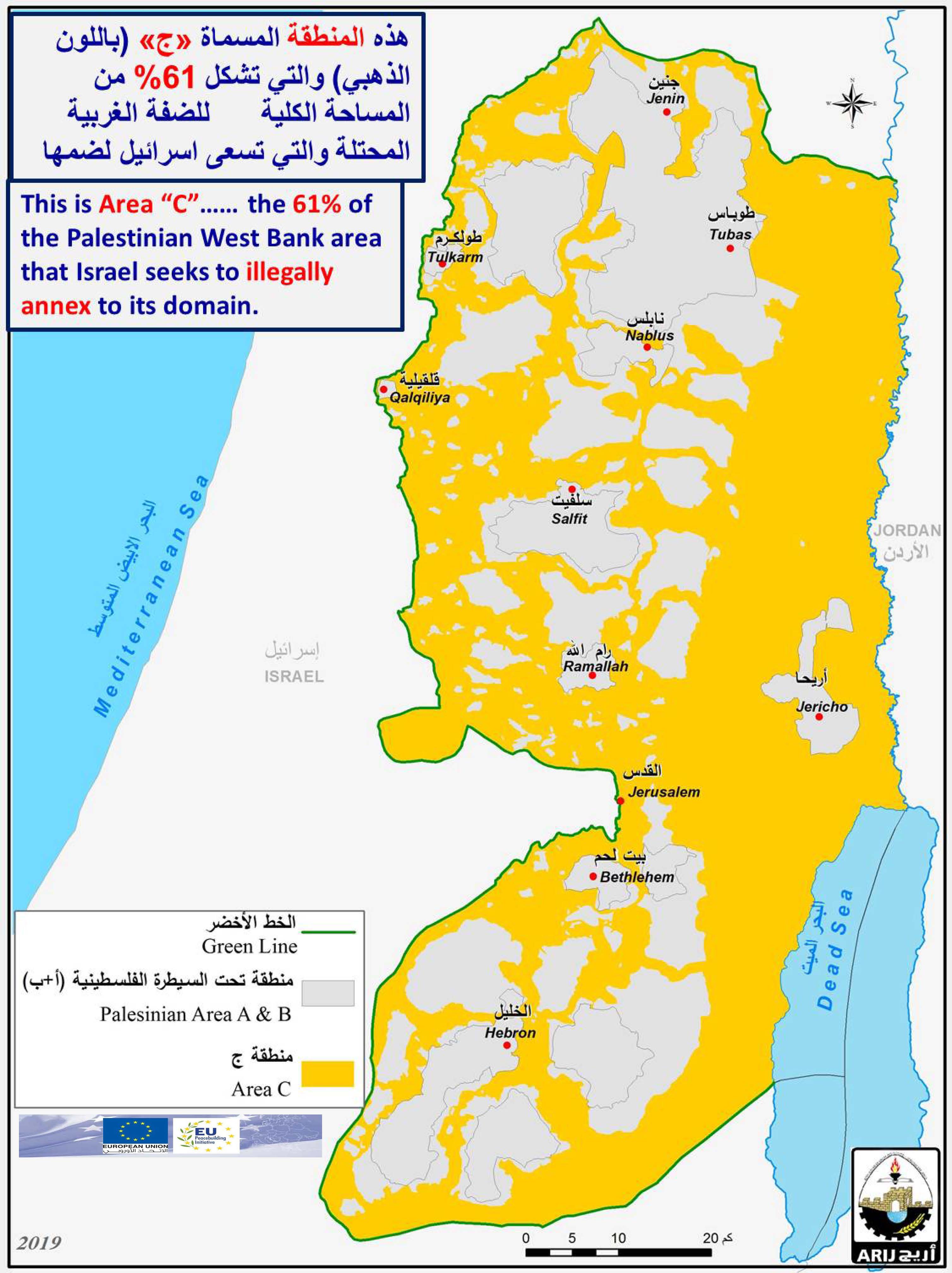
Due to the colossal support by the successive Israeli governments since the year 1967 for the Israeli settlement and to the settlement project in general, the Palestinian residents in all over the opt are in front of a distressing realities where they became confined in their communities, strangulated by settlements and outpost from all sides and more than that, these settlements surpass their scope of development and expansion in a manner that one of the illegal settlements exceeds in its space an entire Palestinian villages and communities .See map 1 :

Map 1: the Distribution of Israeli settlements in the occupied West Bank
In this case study we will address significant examples to shed the light on the dark aspects of the Israeli colonial and expansionist enterprise in the opt.
1- Nahalin Village & the Inflated Settlement of Bitar ‘Ilit
Nahalin village located eight kilometers southwest of Bethlehem Governorate. Its population is 7727 (Palestinian Central Bureau of Statistics – PCBS, 2012). It is bordered by Husan village and the illegal Israeli settlement of Betar ‘Illit from the north, the illegal Israeli settlement of Rush Tzurim from the south, Artas village as well as the illegal Israeli settlement of Neve Daniel from the east, Al Jab’a village and the illegal Israeli settlement of Geva’ot from its west.
The village spreads over an area of 12,124 dunums of lands, of which 496 dunums of lands constitute the Palestinian built- up area (2.8% of the total village area).
During the past decades, the successive Israeli governments managed to confiscate 2988 dunums (24.6%) of lands from Nahalin village to establish one outpost, Six Israeli settlements [1], and military bases on lands privately owned by the villagers of Nahalin. The Six settlements are among eleven Israeli settlements forming ‘Gush Etzion settlements' bloc, which was established after Israel occupied the Palestinian Territory in 1967.
Bitar ‘Ilit is an illegal Israeli settlement established in the year 1985 on 1166 dunums from Nahalin village lands. The settlement is populated by about 40,000 Israeli settlers. Bitar ‘Ilit constitute a typical example on the consequences of the settlement project in the Palestinian Territory, where the settlement and after 27 years from its establishment in the year 1985 became one of the largest settlement in Bethlehem governorate with a total population approximately 40 thousand settlers and expected to reach 100,000 by the year 2020 [2] .
In Bitar ‘Ilit settlement there are dozens of kindergartens , 50 elementary schools , 2 girls high schools , 5 religious schools [3], while in Nahalin village there are only 6 public schools 3 for girls and 3 for boys with 2,367 students[4] .
See table 1 and map 2
|
Table 1: Comparison between Nahalin Village and Bitar ‘Ilit Settlement in Bethlehem |
||||
|
Nahalin Village |
Bitar ‘Ilit |
|||
| Governorate | Bethlehem | % in comparison with settlement | Governorate | Bethlehem |
| Area | 12,124 | 220 | Israeli settlement area – Dunums | 5,492 |
| Palestinian Built up area- Dunums | 669 | 11.4 | Israeli Settlement Master Plan area- Dunums | 5,848 |
| Population | 7,727 | 19.4 | Population | 39,736 |
Source: Geo informatics Dept. at the Applied Research Institute Jerusalem- ARIJ 2012
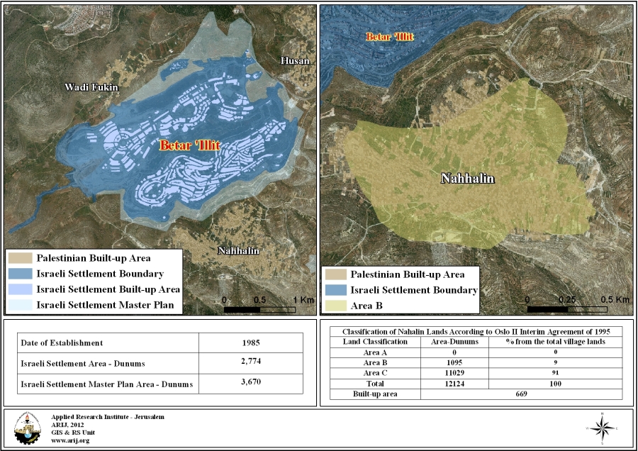
Map 2: Nahalin Village – Bitar ‘Ilit Settlement
2- Beit Sahour….. The Town of Shepherds Filed & “Har Homa”……. the Icon of Netanyahu
Beit Sahour is a Palestinian town located 1 km east of Bethlehem and is the biblical location of the Shepherd's Field. The town is bordered by the segregation Wall along with the illegal settlement of Har Homa from the north, Dahret Al-Nada and Hindaza from the south, Bethlehem city from the west, Al-Khas and An-nu’man, Mazmouria communities from the east.
Har Homa settlement (known to Palestinians 'Abu Ghneim Mountain') is an Illegal Israeli settlement located less than two kilometers north of the city of Bethlehem. The Israeli settlement has been built on the Palestinian-owned lands of Abu Ghneim Mountain which is historically owned by the Palestinian residents of Bethlehem, Beit Sahour, as well as the villages of Um Tuba and Sur Baher.
The construction work on the settlement started in Netanyahu’s first government era in the year 1997 that is when the Israeli bulldozers started to move to the mountain area, chop down the trees, and eliminate the ecosystem there in order to lay down the foundation for the new settlement, which is set to include 3500 housing units to accommodate more than 22,000 Israeli settler.
In Har Homa settlement there are 12 kindergartens, 2 elementary schools, 3 medical clinics, 2 youth centers, 6 care centers, 3 shopping centers, and a hotel while in Beit Sahour there are 10 schools and three medical centers.The Palestinian built up area In Beit Sahour town is 2197 dunums (26.4% from the total village area) while it is almost the same in Har Homa settlement (2188 dunums).
See table 2 and map 3:
|
Table 2: Comparison between Beit Sahour Town and Har Homa Settlement in Bethlehem |
||||
|
Beit Sahour |
Har Homa |
|||
| Governorate | Bethlehem | % in comparison with settlement | Governorate | Bethlehem |
| Area | 8,303 | 379 | Israeli settlement area – Dunums | 2,188 |
| Palestinian Built up area- Dunums | 2,197 | 66.5 | Israeli Settlement Master Plan area- Dunums | 3,296 |
| Population | 13,997 | 63 | Population | 22,261 |
Source: Geo informatics Dept. at the Applied Research Institute Jerusalem- ARIJ 2012
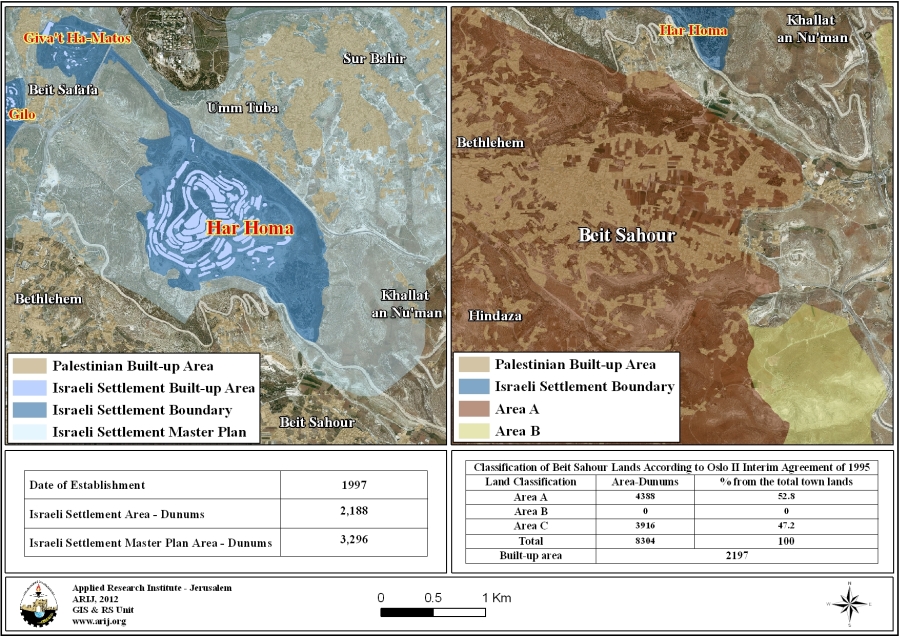
Map 3: Beit Sahour Town – Har Homa Settlement
3- Beit Hanina Neighborhood – Giv’at Ze’ev Settlement
Beit Hanina is a Palestinian community located approximately 5 kilometers to the north of Jerusalem city. It is surrounded by Al-Ram & Dahiyat Al-Bareed from the north, Bir Nabala and Al Judera villages from the west, Al-Nabi Samuel and Beit Iksa villages from the south, Shu'fat and Shu'fat Refugee camp from the South and Hizma from the east. Beit Hanina's total land area is 8,877 dunums, of which 2,368 dunums (26.6%) constitutes the built-up area. The town is located in the center of a cluster of several Palestinian towns and villages; they are Al Ram, Dahiyat Al Barid, Al Judeira, Al Nabi Samwil, Beit Iksa, Beir Nabala, Shu'fat and Hizma, other than that, six Israeli settlements wraps Beit Hanina from several directions.
Giv'at Ze'ev is an Israeli settlement established in the year 1982 and expanded over the years on the lands of Al Jib village and Betuniya town. It is one of the largest Israeli settlements in the West Bank and one of the six settlements comprising the Giv'at Ze'ev bloc (Giv’at Ze’ev, Giva’on, Giv’on Hadasha, Har Adar, Neve Samuel and Mivasseret Zion).
Giv'at Ze’ev settlement area is 2856 dunums and houses a total population of 11,300 Israeli settlers; whereby, the total area of Giv'at Ze’ev settlement bloc is 5821 dunums and houses a total population of more than 18000 Israeli settlers.
The settlement has 4 elementary schools ad one high school and two youth centers while Beit Hanina has 14 schools and educational institutions.
See table 3 and map 4:
|
Table 3: Comparison between Beit Hanina town and Giv’at Ze’ev Settlement in Jerusalem |
||||
|
Beit Hanina |
Giv’at Ze’ev |
|||
| Governorate | Jerusalem | % in comparison with settlement | Governorate | Jerusalem |
| Area | 8,877 | 320 | Israeli settlement area – Dunums | 2,774 |
| Palestinian Built up area- Dunums | 2,368 | 64.5 | Israeli Settlement Master Plan area- Dunums | 3,670 |
| Population | 26,874 | 237 | Population | 11,300 |
Source: Geo informatics Dept. at the Applied Research Institute Jerusalem- ARIJ 2012

Map 4: Beit Hanina – Giv’at Ze’ev Settlement
4- The City of Salfit….. VS……The Settlement City of Ariel!!!
Salfit is a Palestinian city located north of Salfit Governorate. It is bordered by Ariel settlement as well as the Segregation Wall from the north, Farkha village from the south, Bruqin from the west and ‘Amouriya from the east. The total area of the city is 22,663 dunums of which 1,546 dunums (6.8%) constitute the city’s built up area. There are 7 schools (2756 students) in Salfit town and 4 kindergartens.
Ariel settlement was established in 1978. It is located 22 Km east of the Armistice line (Green line) and it is connected to Israel by the Trans Samaria Highway. The settlement expanded over the years from the east and south on lands confiscated from Marda, Kafl Haris and Iskaka villages located in Salfit governorate. Ariel settlement is considered one of the biggest settlements in the West Bank in terms of area (5.18Km² and accommodates about 18,000 Israeli settlers); the second largest Israeli settlement after Ma'ale Adumim in Jerusalem.
The settlement of Ariel is one of the most controversial settlements in the West Bank. It was declared an Israeli city in 2004. It is one of the settlements’ blocks that the former US President George W. Bush, acknowledged to be determinate factors of the final status agreement, where there will be no Israeli withdrawal to the '67 lines; underlying the concept of 'defensible borders'.
Moreover, Ariel settlement is part of a larger settlements’ bloc that holds the name “Ariel Bloc”, it starches across three Palestinian governorates (Ramallah, Salfit, and Qalqiliya) where it encompasses 18 Israeli built-up area; 12 of which are Israeli settlements, 1 collage (+12,000 students), 1 quarry, and 4 industrial zones and 14 synagogues.
See table 4 and map 5:
|
Table 4: Comparison between Salfit City and Ariel Settlement in Salfit |
||||
|
Salfit City |
Ariel |
|||
| Governorate | Salfit | % in comparison with settlement | Governorate | Salfit |
| Area | 22,663 | 491 | Israeli settlement area – Dunums | 4,607 |
| Palestinian Built up area- Dunums | 1546 | 9 | Israeli Settlement Master Plan area- Dunums | 16,885 |
| Population | 9,763 | 55 | Population | 17,700 |
Source: Geo informatics Dept. at the Applied Research Institute Jerusalem- ARIJ 2012
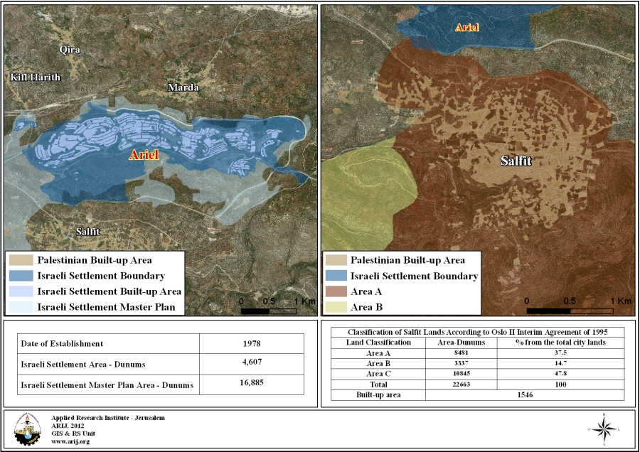
Map 5: Salfit City – Ariel Settlement
5- The City of Bethlehem & the Governorate of Gush Etzion!!!
Bethlehem is a Palestinian city in Bethlehem Governorate located about 10 km away from the city of Jerusalem. It is bordered by the Segregation Wall and Beit Jala town from the north, Hindaza from the south, Al-Khader town along with the Segregation Wall and Gush Etzion settlement bloc from the west, Beit Sahour town as well as the Segregation Wall from the east.
The total area for Bethlehem city is 10,607 dunums while the built up area is 30% (3186 dunums).
Gush Etzion Bloc : Kfar Etzion the settlement, south of Bethlehem is the first Israeli settlement established in the occupied West Bank territory (excluding Jerusalem), early with the outbreak of the Israeli settlements program in the occupied West Bank territory after the 1967 war. Later on, the settlement became the foundation point of what is known today as the Gush Etzion settlements Bloc'' which is located some 20 kilometers south of Jerusalem and 10 kilometers southwest of Bethlehem governorate. Currently, Gush Etzion settlements Bloc includes 11 settlements [6] built on confiscated Palestinian lands and spreads across the western rural area of Bethlehem governorate. However, Gush Etzion settlements Bloc is not entirely located within Bethlehem governorate, as the southern part of the Bloc extend within Hebron Governorate and that includes some of the settlements.
See table 5 and map 6:
|
Table 5: Comparison between Bethlehem City and Gush Etzion Settlement bloc |
||||
|
Bethlehem City |
Gush Etzion Bloc |
|||
|
Governorate |
Bethlehem |
% in comparison with settlement |
Governorate |
Bethlehem |
| Area | 10,607 | 85.4 | Israeli settlement area – Dunums | 12,412 |
| Palestinian Built up area- Dunums | 3186 | 14.5 | Israeli Settlement Master Plan area- Dunums | 21,916 |
| Population | 28,596 | 47.6 | Population | 60,000 |
Source: Geo informatics Dept. at the Applied Research Institute Jerusalem- ARIJ 2012
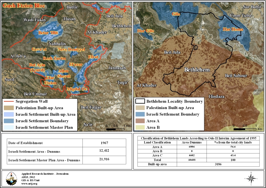
Map 6: Bethlehem City – Gush Etzion Settlement Bloc
Population Density ………The Indicator
During the past two decades, the Israeli occupation boosted up the settlements and the settlers presence in the Occupied West Bank in general and in Jerusalem area in particular with intensive settlements’ constructions and packages of incentives which actually led to the current catastrophic results on the ground concerning the Palestinian communities and their development.
Table 6 clarifies the population density for the five aforementioned examples:
|
Palestinian Locality |
Population Density (Person per Dunum) |
Israeli Settlement/Bloc |
Population Density (Person per Dunum) |
| Nahalin | 11 | Bitar ‘Ilit | 6 |
| Beit Sahour | 6 | Har Homa | 7 |
| Beit Hanina | 11 | Giv’at Ze’ev | 3 |
| Salfit | 6 | Ariel | 1 |
| Bethlehem | 9 | Gush Etzion | 2 |
|
Source: Geo informatics Dept. at the Applied Research Institute Jerusalem- ARIJ 2012 |
|||
According to the table 6 above , the Palestinian population density within the built-up area of Nahalin village its 11 person per dunum (1000 m2), in opposite to that of the Israeli settlers living in Bitar ‘Ilit settlement which is 6 Israeli settlers per dunum according to the Israeli settlements master plan for the settlement……… and it is 6 -7 per/dun, Beit Sahour- Har Homa, 11 -3 per/dun Beit Hanina –Giv’at Ze’ev, while 6-1 per/dun, Salfit- Ariel and 9-2 per/dun , Bethlehem- Gush Etzion Bloc.
On the other hand, and in view of that the Palestinian population density within the built-up areas of the West Bank Governorates soar to 8,537 people per km², in opposite to that of the Israeli settlers living in West Bank settlements which is 1,025 Israeli settlers per m2 for the areas that are occupied by Israeli settlements, according to the Israeli settlements master plan.
Accordingly, the area of Israeli settlements' built-up area and the numbers of Israeli settlers in the OPT increased abundantly where in year 1990, the Israeli settlements built-up area was recorded at 69 km², which has increased to 188 km² in year 2008, an increase of 173%. This in turn has reflected on the number of Israeli settlers living in the settlements, from 240000 in year 1990 to more than 500000 Israeli settlers in year 2008, an increase of 109%.
In view of that the Palestinian population density within the built-up areas of the West Bank Governorates soar to 8537 people per km², in opposite to that of the Israeli settlers living in West Bank settlements which is 1025 Israeli settlers per square kilometer for the areas that are occupied by Israeli settlements, according to the Israeli settlements master plan.
Israel has succeeded to impose the Illegal settlements presence in the West Bank Territory, particularly in Governorates where Israel has strategic interest Israel there. An analysis conducted by the Applied Research Institute showed that the Israeli settlements' built-up area in 5 of the 11 Palestinian Governorates exceed that of the Palestinians. The Governorates are: Jerusalem, Jericho and the Jordan Valley, Qalqilyah, Salfit and Tubas. Furthermore, and by referring to the year 1991 when Israel set out to identify master plans for each Israeli settlement in the occupied Palestinian territory, which on the ground exceed the existing settlements built-up areas; in which case the Israeli settlements built-up areas made available exceed that of the Palestinians in 8 of the eleven Palestinian governorates; adding Nablus, Bethlehem, and Ramallah.
See table 7:
|
Table 7: Israeli Settlements built-area VS Palestinian built-up area in West Bank Governorates. |
||||
|
Governorate |
Governorate Area (km)² |
Palestinian Built-up area(km²) |
Israeli Settlements Built-up Area (km²) |
Israeli Settlements Master Plan Area (km²) |
| Jenin | 573 | 27.872 | 3.959 | 22.766 |
| Tubas | 366 | 5.17 | 7.518 | 12.532 |
| Nablus | 614 | 25.438 | 16.248 | 25.709 |
| Tulkarem | 245 | 19.101 | 3.619 | 5.15 |
| Qalqilyah | 174 | 8.466 | 11.77 | 25.39 |
| Salfit | 202 | 8.719 | 18.147 | 37.959 |
| Jericho | 609 | 7.99 | 23.425 | 77.305 |
| Ramallah | 849 | 47.85 | 31.268 | 61.233 |
| Jerusalem | 354 | 35.646 | 40.011 | 118.72 |
| Bethlehem | 608 | 25.37 | 18.158 | 40.697 |
| Hebron | 1068 | 83.224 | 14.142 | 58.802 |
| Total | 5661 | 294.846 | 188.266 | 486.262 |
| Source: Geo informatics Dept. at the Applied Research Institute Jerusalem- ARIJ 2011 | ||||
Legal & International Status
Apparently, the Israeli right-wing Government headed by Benyamin Netanyahu is using the settlement issue, as tool, to wrap over the international efforts in order to waste as much time as possible, while his top priority is to keep his political and partisan interest and to assure his extremist government coalition despite of the long-term consequences that will be resulted by neglecting the Palestinian rights to have their independent sovereign future state. The existence of the Israeli settlements in the West Bank and their expansions are Illegal and contradicts with the international law rules, United Nations Security Council Resolutions such as 237 (1967), 271 (1969), 446 (1979), 452 (1979) ,465 (1980.
• UNSC Resolution 452 of 1979: 'Calls upon the Government and people of Israel to cease, on an urgent basis, the establishment, construction and planning of settlements in the Arab occupied Territory since 1967, including Jerusalem.'
• Article 49 of the Fourth Geneva Convention of 1949: 'the occupying power shall not deport or transfer parts of its own population into the Territory it occupies.'
• The Forth Geneva Convention in Article 174 also prohibits the 'extensive destruction and appropriation of property not justified by military necessity and carried out unlawfully and wantonly.'
• Article XXXI, Oslo II, 1995: 'Neither side shall take any step that will change the status of the West Bank and the Gaza Strip.
• The Roadmap of Peace signed on April 30, 2003, between Israel and the Palestinians (originally developed by the United States, in cooperation with Russia, the European Union, and the United Nations (the Quartet)) under which the Israeli Government agreed to freeze all settlement, indicated that: The -Government of Israel- immediately dismantles settlement outposts erected since March 2001, and, consistent with the Mitchell Report, [Government of Israel] freezes all settlement activity (including natural growth of settlements).The plan was adopted by the USCR 1515-2003.
• In May 2001, the head of the International Red Cross delegation to Israel and the Occupied Territories said that settlements are 'equal in principle to war crimes'. (Note: 'The transfer, the installation of population of the occupying power into the occupied territories is considered as an illegal move and qualified as a 'grave breach.' It's a grave breach, formally speaking, but grave breaches are equal in principle to war crimes', Rene Kosirnik, head of the ICRC delegation to Israel and the OPT,Press Conference17 May 2001.)
1-
|
Six Israeli settlements built on Nahalin Village lands |
|||
|
Israeli settlement |
Date of Est. |
Pop 2009 |
Area/ Dunums |
| Geva'ot | 1984 | 44 | 135 |
| Betar 'Illit | 1985 | 39,736 | 688 |
| Rosh Zurim | 1969 | 364 | 889 |
| Allon Shevut | 1971 | 3300 | 589 |
| Kfar Etzion | 1967 | 422 | 583 |
| Bat Ayin (Tzurif) | 1989 | 804 | 104 |
| Total | ***** | ***** | 2988 |
2-Former Mayor of Bitar ‘Ilit Yitzhak Pindus.
3-http://www.nbn.org.il/aliyahpedia/community-a-housing/community-database.html
4-Nahalin Village Council -2012
5-Beit Sahour Municipality website: http://www.beitsahourmunicipality.com/
6-Gush Etzion bloc settlements: Kfar Etzion- Alon Shevut- Bitar ‘Ilit- Beit ‘Ayn- Hadar Bitar- Efrat- Eleazar – Geva’ot – Migdal ‘Oz – Neve Daniel- Rush Tzurim.
Prepared by:
The Applied Research Institute – Jerusalem


