
On the 26th of September 2011, the Israeli occupation bulldozer leveled vast areas of lands in Al-Dahir area in Bruqin Village to establish a Power Grid Towers infrastructure for the Israeli settlement of Bruchin. The leveling operations affected large areas of Ad Dahir community and in various locations as well, in addition to constructing a road to connect these locations with each other, causing the uprooting of a number of olive trees in the area. Owners of the razed lands are Tamim Yousef Salameh, Ahmad Nimer Abdil Rahman, Anhmad Muhammad Samara, and inherits of Ali Abdallah.
The Geopolitical Status of Bruqin village
The razed lands are located in an area classified as ‘C’ according to OSLO II Interim agreement of 1995, which falls under the full Israeli control but originally owned by Palestinians of the village and are cultivated by them as well. Map 1 shows the area that has been razed by the Israeli occupation bulldozers to install the Power Grid Towers infrastructure for the settlement of Bruchin. shows the area that has been razed by the Israeli occupation bulldozers to install the Power Grid Towers infrastructure for the settlement of Bruchin.
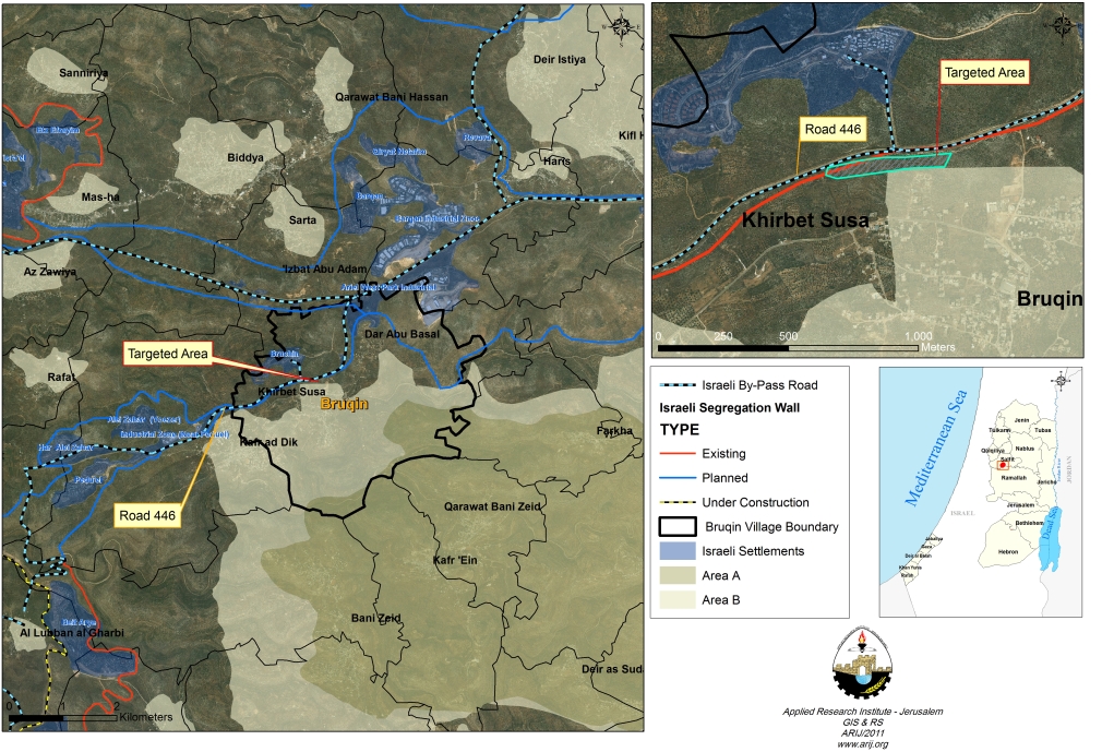
Map 1: the leveling process in Al Dahir area in Salfit Governorate.
Bruqin Village, location and Population
13 kilometers to the west of Salfit city lies the Palestinian village of Bruqin. It is bordered by the Ariel settlements finger from the north, Salfit city from the east, Kafr Ad Dik and Bani Zeid villages from the south, a number of Israeli settlements, Deir Ballut and Rafat villages from the west. The village has a total land area of 12,656 dunums, 678 dunums of which constitutes the built up area. The village has a total population of 4611 inhabitants (PCBS 2010), most of who work in the agriculture sector.
Land Classification of Bruqin village according to Oslo II Interim Agreement of 1995
The Oslo II Interim Agreement signed in September 1995 between the Palestinian Liberation Organization (PLO) and Israel, concluded Israel withdrawal from areas of the West Bank, and that the Occupied Territory be classified into Areas “A,” “B” and ‘C,’ designating varying levels of control. Under the signed agreement, Bruqin village was fragmented to areas ‘A’, “B” and ‘C.’ where:-
- Area A constitutes 12.1% (1531 dunums) of the total area of the village and includes the Urban area.
- Area B constitutes the 40.9% (5187 dunums) of the total area of the village, and includes the urban area and some open spaces.
- Area C constitutes the remaining 46.9% (19927 dunums) of the village, and includes all the agricultural lands, the forests, open spaces, and all the lands suitable for future expansion. Table 1
|
Table 1: Areas Definition in Oslo II Interim Agreement of September 1995
|
||
|
Area A
|
The Israeli army has pulled out fully and Palestinians hold all responsibilities for internal security and Public order.
|
|
|
Area B
|
Palestinians have full control over the civil administration and Israel continues to have overriding responsibility for security.
|
|
|
Area C
|
The Palestinians have responsibility for civil life such as economics, health, and education; while, Israel retains full control over security and administration related to the territory.
|
|
|
Land Classification
|
Area in dunums
|
%
|
|
Area A
|
1531
|
12.1
|
|
Area B
|
5187
|
41
|
|
Area C
|
5938
|
46.9
|
|
TOTAL
|
12656
|
100
|
Source: The Geographical Information System Department, ARIJ 2011
Israeli settlements built on lands of Bruqin village
Since 1967, Israeli military and civilian planners outlined plans to build Israeli settlements in the occupied Palestinian territory. In light of these plans, Palestinian communities witnessed the confiscation of their lands and properties for that purpose. The village of Bruqin is one example among many other Palestinian communities in the occupied West Bank witnessed the confiscation of more than 600 dunums of its lands for the establishment of two settlements, Bruchin and the industrial zone of Ariel settlement. Table 2 gives details of the settlements established on lands of the village.
|
Table 2: Israeli settlements surrounding Bruqin Enclave
|
||||
|
No.
|
Settlement Name
|
Population
2008-2009 |
Establishment Date
|
Area (Dunum)
|
|
1
|
Bruchin
|
470
|
1999
|
268
|
|
2
|
Ariel West Park Industrial
|
Industrial Area
|
NA
|
366
|
|
Total
|
|
470
|
—–
|
634
|
Source: The Geographical Information System Department, ARIJ 2011
The Israeli Segregation Wall plan in Bruqin Village
The latest Israeli revised wall route published on the Israeli Ministry of Defense’s web site on April 30, 2007 shows that 8 kilometers long wall is planned to be constructed on lands of Bruqin village and will cause the isolation of 4053 dunums (32% of the village’s total land area) once completed.
To conclude
During the years of occupation, Israel has resorted to take various measures to confiscate Palestinian owned lands for the various Israeli purposes such as settlement building, road construction, establishment of military bases and many other military uses in the occupied Palestinian territory under the multiple motives. The that Settlement was and is still the cornerstone of Israel’s thinking and the foundation upon which the State of Israel was established and continued to grow over the years. Israel’s refusal to stop settlements’ activities breaches a mass of UN resolutions which call for ending such activity.
-
UN Security Council (UNSC) resolution 446 of 1979 ‘Determines that the policy and practices of Israel in establishing settlements in the Palestinian and other Arab territories occupied since 1967 have no legal validity and constitute a serious obstruction to achieving a comprehensive, just and lasting peace in the Middle East’;
-
also UNSC resolution 465of 1980 ‘determines that all measures taken by Israel to change the physical character, demographic composition, institutional structure or status of the Palestinian and other Arab territories occupied since 1967, including Jerusalem, or any part thereof, have no legal validity and that Israel’s policy and practices of settling parts of its population and new immigrants in those territories constitute a flagrant violation of the Fourth Geneva Convention relative to the Protection of Civilian Persons in Time of War and also constitute a serious obstruction to achieving a comprehensive, just and lasting peace in the Middle East;
Prepared by
The Applied Research Institute – Jerusalem


