On October 24, 2010, the Israeli ministerial committee for Legislative Affairs ratified a bill which considers Jerusalem ‘as a national priority area of the first grade in the housing, employment and education sectors.’ It is expected that the bill proposed by the Knesset member Ori Ariel, a member of the National Union party, will be presented to the Knesset in the near future for initial voting by Knesset members. According to the bill, the priority will be given to many Israeli settlements in the city, including those in east Jerusalem. This bill got the support of several Israeli ministers such as the Minister of Communications, Minister of Environment, Minister of Information, Minister of Tourism, Minister of Religious Affairs, Minister of Security Affairs and the Minister of Immigration.
The truth is that Jerusalem city, especially the eastern part of it, has always been a priority in the eyes of the successive Israeli Governments. Since Israel’s occupation of the West Bank including East Jerusalem, and the Gaza Strip in 1967, Israel rushed to impose unilateral facts in the Palestinian territory through changing city boundaries and imposing laws on land registration processes in order to annex it to its proper. Israel also started building settlements and issuing tenders for constructing new ones, constructing bypass roads, demolishing Palestinian homes, and constructing the Israeli segregation wall to complete the separation of the city from the rest of the West Bank Governorates. Following is a detailed description of the Israeli policies in the city of Jerusalem throughout the years of occupation:-
1- Changing the Boundaries of Jerusalem city: Following Israeli’s occupation of the West Bank, including East Jerusalem, and the Gaza Strip in 1967, Israel imposed a reality on the municipal boundaries of Jerusalem city as it increased its area of control from 6.5 km² (before 1967) to 71 km² (after 1967). Once again in 1993, the Israeli occupation authorities expanded the Jerusalem Municipal Boundaries to become 130 km².
In 2005, the Israeli Jerusalem Municipality disclosed Town Planning Scheme of 2000 that will serve till the year 2020. Accordingly, the boundary of the western part of the city is extended by 40% and the total area of the city is quadrille (i.e. 142 km2). According to the new master-plan, more than half of the eastern part of Jerusalem city is zoned as built-up areas and 24.4% are zoned as open “green natural” areas. The classification of land use varies according to the Israeli needs, as the Israeli Occupation Authorities intended to declare many of the Eastern Jerusalem areas as natural zones and public areas in order to confiscate the lands and change them into Jewish built-up area for Israeli settlers in the city. Perhaps the most obvious example is what happened to Abu Ghneim Mountain which changed from a Nature Reserve ‘Green Mountain’ to a settlement, (Har Homa settlement) in 1997.
A new chapter of the Israeli colonial politics in Jerusalem city is the Jerusalem District Plan (30/1) that was disclosed in September 2008. The Plan accentuate on achieving the Zionist dream of a “unified” Jerusalem capital; as Jerusalem city is extracted from the milieu of the West Bank and consequently entrenching the land of Palestine in a state of “neither two states nor one,” framing a process coined by the Israeli geographer Oren Yiftachel by a “creeping apartheid” (Yiftachel, 2005). This Plan comes after five decades from the last regional plan for Jerusalem that was prepared by the British planner Kendel and named after him. The plan is also known under the name RJ5 (Coon, 1992). However, this plan was not finalized and was lost during the 1948 war.
2) Imposing laws on land policies in the city of Jerusalem: The Israeli government has imposed planning and zoning restrictions in East Jerusalem and enforced impediments on land use. Israel formulated policies that restricted land development and construction. These policies had the aim of imposing the Jewish supremacy in the city and undermining the Palestinian presence in it. The processes of obtaining building permits became long, tedious, and expensive and disadvantages Palestinian residents of East Jerusalem. Buildings constructed without permits are usually demolished by the Israeli Occupation Authorities. Following are some of the policies that were adopted by the Israeli government in East Jerusalem: (1) Confiscating the Palestinian land; nearly one third of the lands in east Jerusalem were confiscated to construct Israeli settlements; (2) decreasing the area zoned as residential in the Palestinian neighborhoods in the city; (3) Imposing restrictions on the volume of construction and the floor area ratios; (4) The Palestinian areas lacked a town planning scheme or zoning plans, were only 38% of the remaining two thirds had an approved zoning plan; (5) House demolition under the pretext of lacking building permits or for security reasons. According to a study conducted by ARIJ, a total of 658 Palestinian houses have been demolished in Jerusalem during the last ten years; (6) 13% of the areas were zoned as green areas where construction is prohibited. The green areas will be released to build Israeli settlements as was the case with Reches Shu’fat and Abu Ghneim (Har Homa) settlements; and (7) Services and infrastructure lacked in the Palestinian neighborhoods resulting in under serviced and unhealthy living environment, the pressure on Jerusalem’s land and natural resources has been devastating as well.
3) Israeli settlements construction: Israel planned to strangulate the Holy city with Israeli settlements and bypass roads, thus decrease the possibility of Palestinian development in the city and limit the prospects for East Jerusalem to be the capital of the future Palestinian state. Illegal Israeli settlements are being built in East Jerusalem in order to increase the Israeli population, maintain a demographic majority of Israelis within the municipal boundaries and strengthen the Israeli sovereignty over East Jerusalem. The number of Israeli settlements in the eastern part of Jerusalem city reached 18 settlements, inhabited today by approximately 195,000 settlers, which is 80.4% of total number of settlers’ population in Jerusalem governorate. The Israeli government also revealed out plans to impose other realities in the city through bidding proposals to build new settlements and neighborhoods to consolidate its control over the city and impose a demographic reality for the benefit of Israeli settlers. Following is a description of the Israeli colonial plans in the city of Jerusalem:
-
The Giv’at Ya’el Settlement plan – 2004:
In June 2004, private initiatives were made by the Israeli Municipality of Jerusalem (status unrecognized) to illegally build a new Israeli settlement on 2000 dunums (according to Israeli sources) of agricultural lands that belong to Al Walajeh, Battir and Beit Jala residents, west of the Bethlehem Governorate. However, the total land area threatened to be confiscated for the construction of this settlement project is 4111 dunums; of which 1766 dunums are located within Jerusalem illegal boundaries and 2345 dunums are from Beit Jala, Battir and Al Walajeh lands. The new initiative intends to create an Israeli settlements chain between Jerusalem and Gush Etzion settlements Bloc (southwest of the Bethlehem Governorate) as a part of the ”Jerusalem Envelope” plan to encompass as much land as possible and to increase the number of Jews within Jerusalem illegal boundaries to create facts on the ground in order to alter the demographic status of the city and influence the outcome of future negotiations regarding Jerusalem as stated by Jerusalem Deputy Mayor Yehoshua Polak: (‘We want as many Jews as possible in Jerusalem to influence the demographic situation’).
The new Israeli settlement to be, which will hold the name of ”Giv’at Yael,” is set to include some 20,000 housing units and accommodates more than 55,000 Jewish settlers. This settlement will physically complete the ring of settlements that separate Jerusalem and encircle Bethlehem starting at Har Homa, extending to Gilo and Har Gilo, linking with the planned Giv’at Yael and continuing towards “Gush Etzion” bloc in the southwest.
-
The Atarot Neighborhood plan:
On February 28, 2007, the Israeli daily newspaper ‘Haaretz’ published on its website a plan submitted by the Israeli Ministry of Housing and Construction to establish a new Jewish neighborhood comprising of 11000 housing units in north of East Jerusalem. The neighborhood, according to Israeli sources, will accommodate Ultra-Orthodox settlers into the area, which come as a non-surprising step by the ministry of Housing and Construction towards the Judaization of occupied Jerusalem city. The area designated for the establishment of the new neighborhood is located within the Israeli illegally and unilaterally redrawn Jerusalem municipal boundaries of 1967. The Jewish neighborhood is planned to be constructed in a densely populated area, north of Qalandyia airport within the Israeli Segregation Wall set to round the occupied city. The location of the settlement to be is south of Ramallah and Al Bireh cities, Rafat, Beir Nabal, Al Jib and Al Judera villages from the southwest and Kafr ‘Aqab and Qalandiya Camp from the east. It important to indicate that the location where the Israeli settlement is set to be, has been designated as ‘no building zone’ for decades, thus denying Palestinians to built and establish community on their own land, however, and once the Israeli government and the Israeli municipality of Jerusalem prepared the plans for a Jewish settlement, the classification of the area became ready for reclassification to suit the new plans and the new purposes.
-
Two new settlements next to Har Homa settlement:
The Master Plan set by the Israeli municipality of Jerusalem (Master plan Jerusalem 2000) indicates the presence of two new neighborhoods added to Har Homa settlement located north of the Bethlehem Governorate, one to its southeast and the other to its northwest. These new neighborhoods will have an approximate area of 1080 dunums. The Master Plan also indicates that the residential area of Har Homa is planned to inflate to 1410 dunums; that is an increase by 350 percent than its current seize of 400 dunums. Har Homa and the additional neighborhoods are to set on an overall 2500 dunums of land.
Map 1: Two new settlement next to Harhoma
-
A new neighborhood at Ramat Shlomo Settlement:
On March 10, 2009, the Israeli regional committee for building and planning in Jerusalem city authorized the building of a new neighborhood in Ramat Shlomo settlement north of Jerusalem city. The new neighborhood includes the construction of 1600 housing units. The settlement of Ramat Shlomo (Reches Shu’fat) was established in 1990 on lands originally confiscated from Beit Hanina, Al Isawiya and Lifta village during the 1970s. Today, the settlement covers an area of 1,624 dunums and is inhabited by 14,320 Israeli settlers. It is worth mentioning that after the 1967 war, the Israeli occupation authorities classified the location of Ramat Shlomo settlement as a Green Area (an area where construction is prohibited). The term ‘green areas’ was an excuse used by the Israelis to confiscate Palestinian lands, to later be used for building purposes, such as settlements. This devious tactic has also undermined the expansion of Palestinian built-up areas in Jerusalem city. The Ramat Shlomo Settlement came as a connecting link between Ramat Eshkol settlement north of Jerusalem city and Ramot settlement northwest of Jerusalem city.
|
Table 1: Palestinian Confiscated Lands for the construction of Ramat Shlomo Settlement.
|
|
|
Community name
|
Area (Dunums)
|
|
Beit Hanina
|
486
|
|
Al-Isawiya
|
983
|
|
Lifta Village
|
155
|
|
Total
|
1624
|
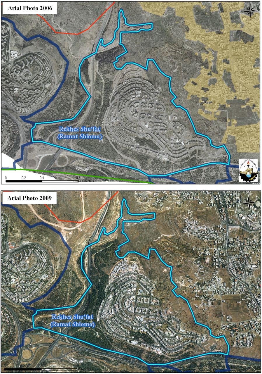
Map 2: The Ramat Shlomo Settlement
-
The building of a new neighborhood in an area between Neve Yaakov and Pisgat Ze’ev settlements. The neighborhood includes the construction of1,200 new settlement units on the expense of Beit Hanina town east of Jerusalem city.
-
Karm Al Mufti (Shepherds Hotel) Plan in Ash Sheikh Jarrah Neighborhood: In 2005, Irwin Moskowitz an American-Jewish pioneer of private Israeli neighborhoods initiatives has revealed a plan to establish yet another one of his infamous, illegal neighborhoods in occupied East Jerusalem. This pioneer of private initiatives has contributed to increase the illegal residency of Israeli settlers in occupied East Jerusalem to extreme levels, only to be surmounted by the Israeli State itself. The plan holds number 11536 and includes the building of 90 settlement units, a synagogue and a kinder garden on a total land area of 40 dunums.
-
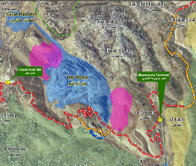
Judaization of Al-Bustan Neighborhood and the Holy Basin project:
During the 90s, the Israeli Municipality of Jerusalem submitted a plan which aimed at Judiazing the area which is called by Israel “the Holy Basin’. The targeted area includes the entire area of the Old City of Jerusalem as well as vast areas from the adjacent neighborhoods and Palestinian communities, starting from Al Sheikh Jarrah and Wadi Al Juz Neighborhoods in the north, At Tur neighborhood in the east and Silwan city in the south. The plan includes (1) the Construction of an archaeological city in conformity to the biblical description of ‘Holy Jerusalem’ under Al-Aqsa Mosque, Silwan neighborhood and parts of the Muslim Quarter in the Old City of Jerusalem; (2) the evacuation of Palestinian inhabitants from their living places and replacing them with Jewish residents starting from Silwan city, and moving towards At Tur neighborhood, Wadi Al Juz, and Ras Al ‘Amud.
Al-Bustan neighborhood in Silwan city south of Jerusalem city was one of the first places that were attacked by the Israelis. In the year 2004, the Israeli Municipality of Jerusalem issued administrative orders to demolish 88 Palestinian houses in Al Bustan Neighborhood (which constitutes more than 90% of the neighborhood’s houses) allegedly for lacking proper authorization from the Israeli Municipality and that the ownership of these houses refers to the Jewish extremist organizations “‘Ateret Cohanim” & “El ’Ad” which intend to build the “City of David” at the targeted neighborhood. Later in the year 2005, the Israeli Municipality of Jerusalem started the demolition process in Al Bustan neighborhood where two Palestinian houses have been demolished. At the end of the year, the Israeli Municipality of Jerusalem decided to halt the demolitions as a result of international efforts on the Israeli government to stop the demolitions, and a petition which had been submitted by house owners to the Attorney General of the Israeli government calling upon him to halt the demolition process.
In August 2008, Palestinian citizens of Al Bustan neighborhood had submitted a master plan to the Israeli Municipality of Jerusalem to obtain building permits for their threatened houses; the Municipality however, informed them that the plan will not be discussed as the Municipality will go ahead with its plan to build a “public park” in the neighborhood. Also the Municipality suggested that the owners of the houses voluntarily evacuate the neighborhood while in return, they will be compensated to live somewhere else outside the neighborhood. Owners of the houses rejected the Israeli offer and the Israeli authorities formally rejected the master plan which they submitted to the Israeli Municipality of Jerusalem during the early weeks of 2008.
Furthermore, on February 21, 2009, the Israeli Municipality of Jerusalem handed over owners of more than 134 Palestinian families (1500 Palestinians) from Al Bustan Neighborhood evacuation and demolition orders notifying them that they have to evacuate their houses for demolishing to make room for the Israeli plan, “King David Garden”. In July 2009, the Israeli Occupation authorities transferred the ownership of 14 Palestinian buildings which occupy an area of more than 28 dunums to Jewish settlement organizations without being ratified by the Israeli Attorney General; in order to build a Biblical Park and Jewish houses instead of the standing Palestinian neighborhood of Al Bustan. Map 3
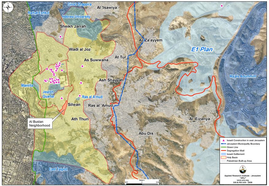
Map 3: The Holy Basin
-
A new Jewish settlement in Ras Al-Amoud neighborhood in East Jerusalem
On the 28th of April 2008, a group of Jewish settlers from ‘Redeeming Jerusalem’ committee coercively took residency in the former building of the Police Station in Ras Al ‘Amoud neighborhood after the Israeli police vacated the building and moved into the new Police headquarter in the controversial E1 area in Ma’ale Adumim settlement bloc. The neighborhood will comprise of 110 housing units over 10 dunums of vacated land in addition to 6 Israeli societies and public organizations. The site of the old police station will be the nucleus of a new Israeli settlement in Ras Al ‘Amoud area called ‘Ma’ale David.’ Map 4:
Map number 4: The Ma’ale David neighborhood
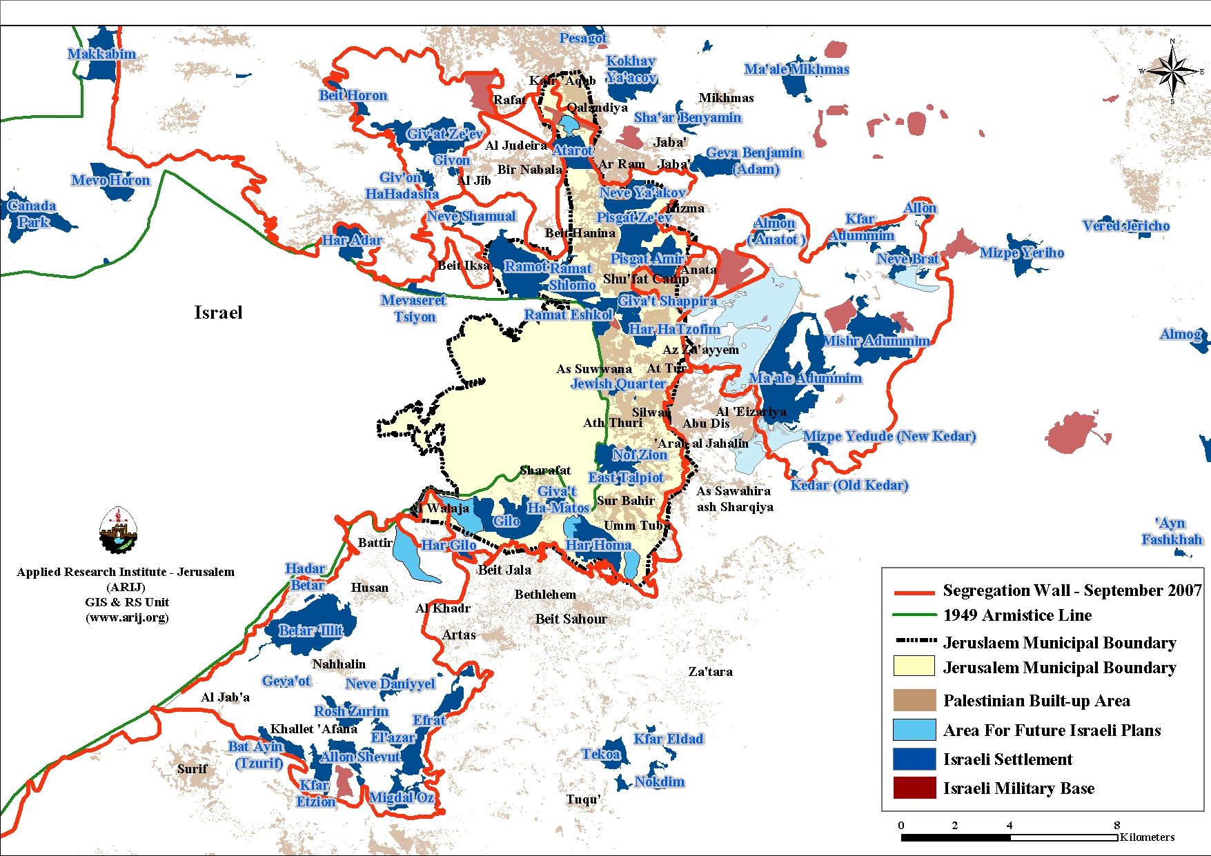
5) The construction of the Israeli Segregation Wall around Jerusalem:
In June 2002, the Israeli government launched its policy of unilateral segregation between Israel and the Palestinian territory by creating a Segregation Zone on the Palestinian lands in the West Bank. The Zone cuts through the western part of the West Bank and runs from north to south grabbing the most fertile agricultural lands, isolating Palestinian communities in enclaves, undermining the territorial contiguity between the Palestinian villages and cities, grasping the natural resources and capturing most of the Israeli settlements.
The Israeli Ministry of Defense revealed the path of the segregation wall around Jerusalem city, which is known nowadays as the ‘Jerusalem envelope’ which is set to enfold Jerusalem governorate and separates it from the West Bank territory. Once completed, the wall will create a new demographic reality that would confine future development of Palestinian localities to marginal proportions, while including major settlements blocs (Ma’ale Adumim settlement bloc, Giv’at Ze’ev settlement bloc and Gush Etzion settlement bloc) within the Segregation Wall along with wide range of open space and nature reserved areas that are likely to change its status later on to become; areas reserved for future settlements’ development projects.
The Segregation Wall (‘the Jerusalem Envelope’) will extend a length of 132 km, around 17% of the total wall length that runs in the West Bank Territory (774 km) and will cause either the complete or partial exclusion of 20 Palestinian communities outside Jerusalem Municipal boundaries and more than 120 thousands Palestinian citizens will be cut-of from the main urban centers where health, educational and social services are located once the wall is completed around Jerusalem city. It is worth mentioning that most of the Palestinian communities that will be cut off from Jerusalem city are communities with high population densities such as Shu’fat refugee camp, Ar Ram and Al Barid outskirt and Ash Sheikh Sa’ad which Israel seeks to deprive them their living and education and insurance rights.
|
Table 2: Israeli settlement plans and their impact on the demography of Jerusalem city
|
||||||
|
The current demographic status in Jerusalem city
|
The future status of Jerusalem: upon the completion of the segregation wall
|
|||||
|
Population in Jerusalem
|
Population
(thousands)
|
Percentage
(%)
|
Will be excluded upon wall completion
|
Will be annexed to Israel upon wall completion
|
percentage
|
Total
|
|
Palestinians
|
254
|
35 %
|
120
|
–
|
16%
|
134
|
|
Israelis
|
470
|
65%
|
–
|
163
|
84%
|
696
|
|
Total
|
724
|
100%
|
–
|
–
|
100%
|
830
|
Source: GIS UNIT – ARIJ, 2010
Map 5: Plan of Greater Jerusalem
5) Demolition of Palestinian Houses:
It became an obsession of the successive Israeli governments since 1967 to win the demographic battle over Jerusalem to their favor. Hence, in the decades of Israeli occupation to follow, Israel has systematically planned and practiced all sorts of operations to eradicate the Palestinian existence from the occupied city that might ultimately threaten their quest of Jerusalem as “the eternal, undivided capital of Israel”. Accordingly, Israel employed all within its capabilities to ensure “Jewish dominance” in the city, regardless of the means and methods used to realize their quest; thus they violated repeatedly every aspect of the international law and facilitated the establishment of illegal settlements, demolished thousands of Palestinian houses and crippled the city economy worse than anytime ever before.
Israel targeted Palestinian houses in east Jerusalem since the first day of its occupation of the territory in 1967. The first incident took place when an entire sector of the Old City of Jerusalem (Al-Magharbeh neighborhood, more than 700 Palestinian houses) was demolished to establish the Jewish quarter to settle in the Israeli settlers on the ruins of Palestinian houses. Israel continued applying its racism displacement policy throughout the years of occupation as it demolished thousands of Palestinian houses, and issued thousands of demolition and evacuation orders against hundreds of Palestinian houses under various pretexts such as demolition as a collective punishment, administrative demolition (unlicensed construction) and demolition for security and military purposes. A statistical analysis prepared by the Applied Research Institute Jerusalem (ARIJ) showed that during the period of year 2000 and September 2010, Israel demolished nearly 660 Palestinian homes in East Jerusalem and threatened to demolish around 2,800 homes.
To conclude
Israel is upholding its illegal claim over the occupied city of Jerusalem as being part of what the Israelis call ‘the unified city’ since they translate their claim into tangible steps with plans to selectively enwrap areas considered significant to Palestinians to fulfill their Vision. The process of enhancing settlement building and Wall construction will contravene the demographic situation in the city and impose a new reality on the ground that cannot be squared once negotiations over final status issues begin.
Prepared by
The Applied Research Institute – Jerusalem
The Applied Research Institute – Jerusalem