
Displacement, Requisition and Hidden Benefits: On Settlements in the West Bank
Prepared by: Nidal Alayasa
In the light of the November declaration of their freeze, Israeli settlements in the West Bank remain healthy and just as intrusive and obstructive to Palestinian daily lives. However, this is only a single-minded outlook on their effect on Palestinians. The settlements, and their baggage, remain the most insurmountable obstacle in the face of a sovereign Palestinian state. The existence of these settlements, and their continuous and rigorous growth, continues to hinder the economic development, social continuity and the fragile political balance in the Occupied Palestinian territories in the West Bank.
Separate and Conquer: Land, People and People:
The settlements in the West Bank are not only controversial because of their effects, but the legitimacy of their mere existence is a point of discussion as well. In the many extensive attempts to investigate the legality, or lack thereof, of Jewish settlements in the West Bank, the only consensuses is that their existence violates the Fourth Geneva Convention. The article in question, article 49, states its 6th paragraph that “the Occupying Power shall not deport or transfer parts of its own civilian population into the territory it occupies.” B’Tselem argues that any attempt to use the lands of the west bank for the benefit of the settlements is “forbidden and illegal in itself, even if the process by which the lands were taken were fair and in accordance with international […] law.”[ Along the same tone, MK Mossi Raz of the Meretz party agrees: “settlers continue to exert organized control over land [in the West Bank] in an illegal manner.” Many other humanitarian NGOs share the same point of view. The ICJ, in its majority opinion in the case of the Wall in the West Bank, presented a similar interpretation of the Fourth Geneva convention in 2004. After the landmark ruling, the discussion has shifted away from the legality of the settlements, since it became less fruitful for pro-settlement entities to continue arguing a seemingly losing point. This in itself is an intriguing development; it is a testament to the power that those entities have over the general topic of conversation regarding the conflict.
The first settlement that was built in the West Bank after its occupation in 1967 was Kfar Atzion in the same year. Since then the expansion of settlements was based on an elaborate plan to change the nature of the Occupied Territories into an unchangeable, yet illegal reality. The initial plan, Allon plan as it was known, was to divide the West Bank in half with a strip of Jewish settlements along the lines of latitude. The Palestinian part was to be ruled by Jordan and the new Jewish settlements were to become Israeli ruled. Although the plan was not ultimately implemented, the growth of the settlements in the West Bank (including East Jerusalem) remained staggering in magnitude and alarmingly similar in purpose to that of the infamous plan. Kfar Atzion, on the other hand, remained relatively limited in size. The settlement was built on a small Jewish community that was built on the same territory earlier in the 20th century. Its size is puzzling only if taken out of context. However, in the context of the West Bank’s settlements, and like many of them, this settlement is there largely to preserve a fabricated connection to a stolen land. This settlement is an agricultural community that through this attempt to draw a connection to the West Bank as the land of “Ertz Israel”.
The plan was abandoned in favor of less limiting paradigms. Ariel Sharon, 28 years before becoming Israel’s prime minister, lead a view point that wanted a similar purpose for settlements. To Sharon, dividing the Palestinians in the West Bank into at least two separate areas was imperative. A method of control that was employed previously by the British mandate, and every successful military occupation, i.e. divide and conquer. Moreover, this plan remains more cunning. It meant that Palestinians could not claim back the land as a part of an “eventual” Palestinian state. The theory was that the status quo would be made too concrete to be altered. It, therefore, would secure an Israeli presence in the West Bank that is too great to remove, while establishing a control over the remainder of the Palestinian “territories”.
Benjamin Netanyahu had similar views to those of Sharon. In 1989, while still a junior Knesset member, Netanyhu stated “Israel should have exploited the repression of the demonstrations in China, when world attention focused on that country, to carry out mass expulsions among the Arabs of the territories.” He meant to control as much land, not only while isolating its people, but also through the out-casting of its people or forcing them into conditions that are sever enough for them to leave “voluntarily”. This obvious, and disturbing, Tiananmen Square reference is only a reflection of the man’s ideological background. Netanyahu, since then, have amazingly disguised as a partner in peace, much like Sharon did after Sabra and Shatila. The two politicians’ views are very well represented in today’s settlement system.
The plans continued to the extent of 200 settlements and 560 thousand settlers in the West Bank, including East Jerusalem. The Israeli negation to this statistic is a very interesting one. Israel only recognizes 121 settlements as such, or as they are called by Israel, “communities”. Israel does not include all those illegal settlements in East Jerusalem, nor does it recognize 60 outposts spread around the West Bank that even Israel recognizes as illegal. Such outposts in the West Bank are among the most protected by the ideological settlers. At the very few times that the state removed them, they were shortly rebuilt, or relocated, close enough to a parent settlement in order to be called “neighborhoods”. See Map 1
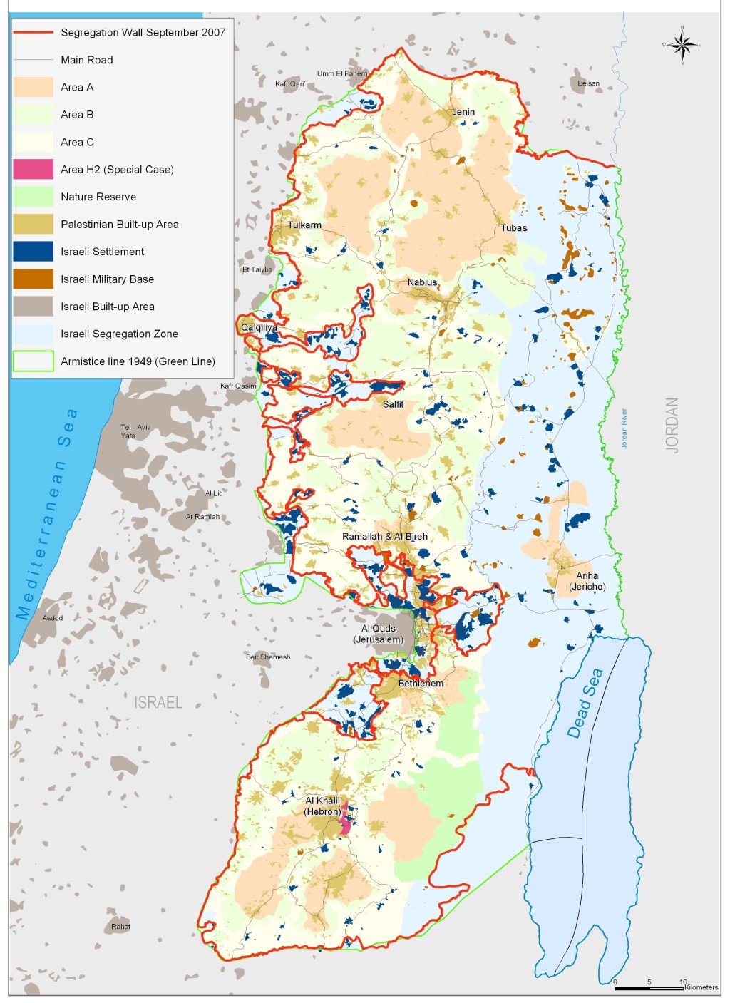
Map 1: Israeli settlements in the West Bank
Although the divergence of the settlement enterprise from the Allon plan is noteworthy, it is still alarming that plans such as Binyamin Elon’s plan are still viewed as a possible solution. His “Right Road to Peace” plan is based on exiling all Palestinians from Gaza and the West Bank, while “allowing” them to establish a homeland in Jordan. This plan is the summit of racist thinking, not only does it presume the Palestinians inept to populate their land, it also lumps up Jordanians and Palestinians as one people. This very though is not a new one; Palestinians are only recognized by many Israeli entities only as Arabs, which effectively negates a national identity and any indigenousness of the private people. This plan, however, was not received with enough grace in Israel and Jordan to cause the stir it ought to. However, unsettlingly enough, an authority of enough weight in the figure of U.S. Senator Sam Brownback, a presumed Republican candidate for the presidency in 2012, endorses the plan. On the other hand, similarly radical ideas are still very strongly presented as solutions, some even by the new mainstream Israeli politics; namely in the figure of Avigdor Lieberman, the Secretary for Foreign Affairs in Netanyahu’s second cabinet.
The persistent problem that the Palestinians face with settlements is their continuity. On the one hand, the Labor party was the first to suggest the original Allon plan, the same party whose leaders signed Oslo on behalf of Israel. This, if it means anything, simply means that the settlements are a Zionist project not a mere partisan one inside Israel. On the other hand, the latest elections made the Labor party’s decision-making ability almost minimal and gave way to the extreme right to step in. this means that any compromises that the left would have made for the sake of peace and to solve the settlers’ dilemma is now eliminated into the ideological spiral, led by Lieberman.
The settlements enterprise in the West Bank is different from any other colonizing movement by an occupying force in an occupied territory, however certain similarities are bound to be found. Graham Usher argues that such settlements “must obtain a measure of political, military, and economic independence from their metropolitan sponsors. They must achieve military hegemony over, or at least normal relations with, their neighboring states. They must acquire international legitimacy. And they must solve their ‘native problem.”” This last concern, to him, is that of the original inhibitors of the occupied lands, which Usher argues is the only one that Israel has not managed to solve. On the other hand, it remains noteworthy to point out, which Usher fails to mention or simply overlooks, that settlements must establish a complex state of interdependence amongst each other. Such interdependence comes in the shape of Bypass roads, extended municipal areas and extravagant jurisdictional territories around them. This is what allows them to form the connection amongst themselves and the separation between the Palestinian territories, which was the basic reason behind their initial foundation. Furthermore, to many settlers this is viewed as the only way for them to insure their survival.
By contrast, as aforementioned, the Israeli successive governments have failed to solve the “native problem”. The attempts have centered on dispatching the people from their land, but, perhaps more importantly, on separating them from each other. This shift has been a matter of adapting to the international climate and the fluctuation in the global focus on the Palestinian/ Israeli issue. However, there remains other sides of this separation, one of which is the separation of Palestinians from their connection to their lands. Trees, and crops, have been the subjected to targeting that has only been view from an economic standpoint. This is a rather naïve assumption. Olive trees signify the depth of the Palestinians’ connection to the land of their fathers and a symbol to their resiliency in the face of the occupation. Irus Braverman argues a similar point. However, he continues to say that the uprooted olive trees were replaced with pines, at least in the north of historical Palestine, by Israel to fight back this Palestinian connection to the land. Moreover, and rather differently, settlers in the West Bank have made it a habit to burn Palestinian corps. This is not just an act of nihilism or a simple will to destruct to limit the usefulness of the territories to the “other” or “enemy”. By contrast, this was an attempt to return the land into a neutral stage from a historical standpoint; this to say it was/is an attempt to destroy the Palestinians’ claim to a connection to their land while clearing room for a new Israeli connection to be formed.
The settlements in the West Bank have grown to the point of 200 settlements and outposts since the Allon plan. These settlements now serve as a home for 560 thousand settlers. These settlements serve many purposes, as aforementioned, but perhaps control is the most obvious. Settlements aim to control their build-up areas also; using their topographical positioning on major hilltops in the West Bank they oversee the movements of Palestinian populations by simple effect. The first settlements from 1968-1977 were constructed in strategic positions. The fact that the first three settlements were constructed to surround newly occupied East Jerusalem is only the first piece of evidence to this claim. The reasoning behind this was the need to separate Jerusalem from the neighboring Palestinian cities. Moreover, this trend continued as Israel continued to separate the West Bank from neighboring Arab countries. Naturally, settlements were positioned along the borders in the Jordan Valley, the Egyptian front and Gaza, and the Golan Heights. since the . These settlements now serve as a home for 560 thousand settlers. These settlements serve many purposes, as aforementioned, but perhaps control is the most obvious. Settlements aim to control their build-up areas also; using their topographical positioning on major hilltops in the West Bank they oversee the movements of Palestinian populations by simple effect. The first settlements from 1968-1977 were constructed in strategic positions. The fact that the first three settlements were constructed to surround newly occupied East Jerusalem is only the first piece of evidence to this claim. The reasoning behind this was the need to separate Jerusalem from the neighboring Palestinian cities. Moreover, this trend continued as Israel continued to separate the West Bank from neighboring Arab countries. Naturally, settlements were positioned along the borders in the Jordan Valley, the Egyptian front and Gaza, and the Golan Heights.
Similarly, settlements were constructed around the major cities in the West Bank to serve perhaps the most important aspect of separation and conquering, namely separating these cities from each other. This policy of isolation makes it rather impossible to achieve continuity among the Palestinian cities. In a place as small as the West Bank this connection is crucial. Cities, in the West Bank, are very small by any global standard, thus they serve as markets for each other’s goods, solutions for health problems and centers of the administrational territories. Bethlehem, Jenin, Qalqilya, Salfit, Tubas and Jericho number 50 thousand people or less each, which makes it impossible for them to survive as healthy cities without access to Ramallah, Nablus and al-Khalil (Hebron).
During the 1990s, the Oslo peace process was the dominant fixture in the conflict. It is widely recognized that the settlements increased disproportionately in size and number during the 90s. ARIJ, in a 2008 report, says that during the period 1991-99, 21 new settlements were started in the West Bank. Moreover, Peace Now reported that during the same period there was an increase of 104 thousands settlers in the West Bank alone (excluding East Jerusalem), an increase of 110.7 percent. On the other hand, a valid, pro-Oslo, argument can be made that Israel would have illegally established more settlements, and build new houses, regardless of the existence of the agreement. The rate of the growth from year to year actually dropped during the 90s. Although this might be mainly because the number of settlers over all increased, which mathematically drove the percentage down, however gross increase in the number of settlers was at its highest to date during that period. The empirical evidence that the plans would have been carried to a further extent, or otherwise, without Oslo remains, by definition, lacking. However, what is known is that settlements were growing before the 1990s and continued at the 90s rate after their end. Regardless of the influence that Oslo had on the number of settlers in the West Bank, its effect, which will be visited again below, was much more noticeable regarding the policies with which they are to be treated in times to come.
Water and Wastewater:
Settlers in the West Bank only share with the Palestinian population in the West Bank only the distinction that they inhabit “Judea” and “Samaria”, and differ in nearly all other life aspects. In the mostly dry West Bank, B’Tselem reported that, the average daily per capita water consumption for the 48,000 Palestinians residents of Tubas is 30 liters, while it is 401 liters for the 175 settlers, per capita, who live 12 kilometers away in Beka’ot settlement. The figures are closest between Bethlehem and the neighboring Efrat at 71 liters to 217. The same report states that the average daily use for toilet flushing in Israel is 55-60 liters, about 160% the total per capita consumption in TubasThe World Health Organization recommends that the per capita minimum be at 100 liters per day. In addition to the obvious health and well being ramifications of water shortages, these limitations affect the economies of the Palestinian localities. Water shortage can be devastating to the 33 percent of the Tubas residents, and the 17.9 percent of the residents of Bethlehem, for whom agriculture is the main source of employment.Moreover, this water situation is an obstacle to the industrial life. The Bethlehem area is known for its building-stones industry. 15.6 percent of the residents of the Bethlehem district work in the mining industry, mostly in this particular branch. This industry’s basic operations cannot run without great amounts of running water to facilitate it. More generally, in a separate, 2007, B’Tselem study, more than 190 thousand Palestinians in the West Bank live in communities that are not connected to running water sources. At the same time, the daily average per capita of water consumption among Palestinians in the West Bank sits at 73 litters, 14.3 percent of those Palestinians owe their employment to agriculture. By contrast, the daily water consumption average for settlers per capita is 211 liters.
Another major water issue in the West Bank is wastewater. In their report, Foul Play, B’Tselem reports that 5.5 mcm of settlement wastewater, 31 percent of the total wastewater produced in settlements, flows directly into the West Bank’s water sources, such as valleys, springs and water conservatories. Similarly, 17.5 mcm of East Jerusalem’s wastewater is channeled east toward the West Bank annually. ARIJ, in September 2008, reported that the entire Palestinian population in the West Bank produces 52 mcm, 2 short of the settlement’s production of wastewater. This means that the Israeli settlers produce roughly 5 times the amount of wastewater that Palestinians do in the West Bank per capita.
This dilemma is not only caused by Israel’s negligence of the well being of the Palestinian inhabitants in the West Bank, it is also the result of poor planning that is very uncharacteristic of settlements. Many of these settlements did not have plants to treat wastewater, while many others had insufficient and/ or ineffective solutions to the problem. In a hearing in front of the Knesset, Yael Mason of the Ministry of Environmental Protection stated that many treatment plants at settlements “do not meet requisite standards and pollute both the Mountain Aquifer and streams.” He added that they “did not have a proper solution for wastewater.”
The settlement of Bitar Illit is a good example. Bitar is home to 34700 settlers and covers 4685 dunums of the land of Batir, Husan, Nahhalin, and mostly Wad Fuki’n villages in the Bethlehem district. Agriculture is the principal source, and sometimes only source, of income for most of the villagers in all four villages. Bitar is an ever-growing settlement. As a result, new houses are not offered new means of support, however they are connected to already-existing networks including the wastewater treatment facilities. This has resulted in catastrophic accidents at times to the neighboring Palestinian villages. For examples, between 2006-2007, the pipes and the treatment facility in the settlement broke 25 times and flooded 100 dunums that belong to Palestinians from Wad Fuki’n. Moreover, in October of 2008, raw wastewater flowed onto the fields of Wad Fuki’n for 4 straight days. This is not helped by the fact that Bitar Illit is significantly on a higher piece of land than Wad Fuki’n’s fields, which is the case in many a situation with the settlements of the West Bank. See Figure 1

Figure 1: Betar Illit Settlement between 2006 & 2009
The farmland of Wad Fuki’n, and that of the aforementioned neighboring villages, is among the most fertile in all of the West Bank. The wastewater drains the land’s natural resource making it less fertile while polluting the scarce, natural water resources that cannot be substituted or, otherwise, rehabilitated. Wastewater not only affects the crucial aspect of the Palestinian economy that is based on agriculture, but it also contribute to the problem of chronic water shortages in the West Bank as settlement wastewater destroys more water conservatories. It is almost appropriate to believe that a certain level of indifference by the civil administrations of the settlements exists. This is only supported by the fact that only the villagers’ lands and water sources are destroyed not those illegally acquired by the settlers.
The population of the settlements not only produces wastewater from human basic uses, but also raw industrial wastewater. This is rather evident in the case of the settlement Barkan in the north of the West Bank. The Israeli MEP reported that in the industrial zone in the settlement, treatment methods of highly toxic chemicals are “usually primitive”. The wastewater from the factories has leaked into the groundwater under the industrial zone. Similar reports were presented about the cow pens of the Rosh Tzurim settlement.
The problem of settlement wastewater does not stop here. In Al-Birah, Israel refused to allow the building of a wastewater treatment facility without the inclusion of the Pasgot settlement in the plan and treating its wastewater in the facility. Although the settlement’s wastewater is now treated in the facility the Israeli government refuses to pay for this service.
A representative case is that of the Salfit district. In the district of Salfit lies one of the West Bank’s largest settlements; namely Ariel. Ariel’s wastewater treatment facility was one of the least effective in the West Bank until it became dysfunctional in 2008. Since then, Israel has refused to build a new one “claiming” that it wanted to build a shared one with the city of Salfit. The Palestinian side rejected this proposal, but most importantly the German bank KFW that undertook the funding of the new facility rejected it. The reason for KFW’s rejection was that it would not fund such proposals in West Bank settlements. Ariel also cited that the facility would cost much more than what the municipal budget could afford. The Israeli side, meanwhile, have undermined any plans to build a separate facility to treat wastewater for Salfit. Israel, first, stopped the building of the plant, because it claimed that the pipeline collection was too close to a planned building area for the Ariel settlement. The Civil Administration then stopped a different proposal in area C for the plant. On the other hand, they suggested a location that would multiply the costs of building multiple times over. Finally, the Civil Administration agreed to a plan to use area B for the building, however by that time KFW has suspended funding the project due to the absence of an agreed upon site for the construction. As an obvious result, rain continues to flood the stream of wastewater causing it to cover more agricultural lands in the Salfit district.
Here, it is not only feasible to question the Palestinian rejection of the Israel secondary plan to join the treatment facilities for Salfit and Ariel, but it is also irreplaceable to the understanding of a crucial argument. That is that the Palestinian side rejects any cooperation with the Civil Administration or the municipalities of settlements in the West Bank as a general rule. Behind this stance is a rather valid logic; that is any cooperation with settlements legitimizes their existence. Thus, agreeing to the Israeli plan would be legalization and formalization of the disposition, not just a mere compromise.
Of Land and Security:
The scarcest resource in the West Bank, and in mandate Palestine in general, must be recognized to be land itself. 11.5 million people, both Israelis and Palestinians live in the Holy Land today, 2.7 to 3 million of those live in the West Bank. Although this might not seem to be over populated in comparison to Gaza, it remains a situation that can, and should, be improved. Of the general population of the West Bank, 580 thousand are settlers, whose settlements are built on 3.3 percent of the general area of the West Bank. However, these settlers have jurisdiction over 8.5 percent of the West Bank that is not to mention that the effective authority of the Civil Administration stretches well beyond that to the brick of 42 percent of the West Bank. Meanwhile, the Palestinian build up area amounts to 5 percent of the West Bank, while they amount to more than 80 percent of the population. It is also worth mentioning that if the settlements in the West Bank were evacuated of settlers, they would solve the housing problem for 18% of the population of the West Bank.
The existence of settlements in the West Bank is illegal, in eyes of the ICJ, and problematic, in the eyes of Israel. Expanding these settlements, on the other hand, is a necessity for Israel for this proves that settlements are living communities, which is an argument that can be presented to the international community in favor of their existent. This illusion of “natural growth” allows Israeli leaders to be quoted supporting the settlements like it did Sharon in 2003; “What do you want, for a pregnant woman to have an abortion just because she is a settler?” Here, there is a fact that is impossible to ignore. The settlements constitute 6.5 percent of the general population of Israel, while the growth rate of the settlements in the West Bank is three times higher than that inside Israel; settlements grow at 5 percent annually, while the rest of Israel grows at 1.7 percent It also impossible to ignore the fact the new Jewish immigrants to Israel are channeled systematically into the settlements. Moreover, they are given incentives (tax cuts, for example) just to live in the settlements in the West Bank.
The construction of new homes is similarly misleading. Israel often refers to these new constructions as “neighborhoods” as oppose to settlements, or “new communities”. Israel tries to legitimize these expansions through this manipulative language. Some of these new neighborhoods include twenty times the number of houses that was in the “parent settlement”. Moreover, some of these new constructions are not reasonably close enough to the center of the “parent settlements” to be considered a part of it. For example, B’etslem cites in its annual report that the “authorities classify Sensana as a neighborhood of the Eshkolot settlement, but its residents consider it an independent community. [Moreover,] the “neighborhood” lies three kilometers away from Eshkolot.” These “neighborhoods” have different names, administration and general characteristics than their supposed parent settlements. However, their innovative Israeli titling as “neighborhoods” does not conceal the fact that they attempt to control more land and more Palestinians. See Map 3
Map 3: The settlements of Eshkolot and Sinsanah in Hebron Governorate
The new “neighborhoods”, as well as the parent settlements, were a part of the planning of the massive illegal land disposition that accompanied the building of the Segregation Wall. The reasoning that was originally declared behind the Wall was stopping attacks beyond the Green Line by the Palestinian fractions. In 2002, then-prime minister Ariel Sharon endorsed the unilateral project. His idea, at its most public face at least, was the separation between the West Bank, on one side, and East Jerusalem and Israel on the other. This was for him the only way to achieve security for those Israelis living there. The Knesset then accepted the project in 2002, when the plan would put 11.2 percent of the West Bank on the west, Israeli-controlled side of the Wall. Thus, the Wall, which was 645 kilometers long at the time, included most of the settlement blocs in the West Bank as well as 633 km2 of the Palestinian lands to the east of the Green Line (1949 Armistice Line).
Initially, the civil administration, as well as other Israeli authorities, emphatically denied that the planning of the course of the Wall took the protection of the settlements into consideration. However, since then the Civil Administration admitted to the opposite. Moreover, they were eager to present arguments as to why this was in no violation of any international laws. The Civil Administration also presented circumstances that it viewed as legitimizing of their new public position. As a public relations arrangement, their arguments have been rather inclusive, for they have approached the issue from enough angles to make the argument almost airtight.
First, the Civil Administration admitted to having taken the existence of settlements in the West Bank and East Jerusalem as a defining factor for the course of the Wall. During this dramatic shift of the philosophy of the public image of the Wall, the interim agreement in Oslo became exceedingly important again. Israel contended the Interim agreement gave Israel the privilege and the responsibility of protecting the Israeli residents of the West Bank, i.e. the settlers. The State Attorney’s Office said in 2005: “Indeed, part of the route was planned with the objective of providing protection also for Israeli residents living in Judea and Samaria, who also suffer from terror attacks. However, there is nothing wrong in this, for… in accordance with Supreme Court decisions, and according to the Interim Agreement, Israel is responsible for the safety of Israelis in Judea and Samaria. Israel is of the opinion that the barrier is one of the necessary elements of this protection, so long as the route is proportionate.”
The word “proportionate” creates sufficient loopholes for the general plan that could and would be exploited. This word, as much as “neighborhood” before it, means that the judgment is left for that of the Civil Administration to show the limits of the settlements. Moreover, it leaves the security decisions to the military leadership in the West Bank to decide on military zones. Not to mention that it virtually leaves all scenarios open as far as the length and course of the Wall are involve as long as they are “proportionate”.
Second, the plans did not only take the existing settlements into consideration, but they also took the settlements expansion plans as another key factor in determining the course of the Wall. In the case of Beit Surik, in front of the Israeli High Court, the state limited itself, regarding to plans concerning the Wall and settlements, to only consider approved outline plans for the course of the Wall. As prejudiced as the ruling might seem, it makes the inclusion of many plans that are under consideration for the expansion of settlements illegal. However, the State Attorney’s Office diverged from this ruling when it was asked to comment on the case of the settlement of Zufin. They said that: ‘In planning the route in the area, consideration was given to the existence of a plan that is under preparation, but has not yet gained official approval.’[ Although the case of Zufin will be observed in more detail below, it is important to note this landmark case. The Wall would “protect” Zufin from the south and east; meanwhile it will separate and affect at least four of the villages that surround it, not to mention the city of Qalqilya. See Map 4

Map 4: The Israeli Segregation Wall plans on lands of Qalqilyia Governorate
This new reality also means that the Wall is not meant to be temporary. This is the notion that the successive, Israeli governments have portrayed and treated as a principle part of the security argument. It is meant to say that the wall only stands there as long as its costs to the Palestinians are “proportionate” to their benefits. This however is a determination that no Israeli entity is qualified to make. For it suggest that an ethnic group decides what is in another separate ethnic group’s best interest.
Moreover, the security argument is rather fragile on a different account. The initial reasoning behind the building the Wall has been the prevention of the entrance of Palestinians into Israeli territories. Although majority of this target group are those Palestinians without permits, it has been made clear throughout the process that Israel is not enthusiastic about the entrance of Palestinians with permits. This carries over to the attempts to lower the number of permits given to Palestinians. Thus emerges the byproduct dilemma that the Wall creates. The state is obligated, by self-binding regulations, to give permits to Palestinians, who are separated from their farmland by the Wall. The result of this paradox is that if more farmland is confiscated the need will emerge to issue more permits to Palestinians who other wise would not have them. It is self-evident, therefore that this confiscation of land is about more than just the security requirements of the Wall.
It is, in addition, equally self-evident that the longer the Wall, and the “seam zone”, are, the more soldiers it will require to secure it. This is puzzling because soldiers have been as intriguing of target, for Palestinian fractions, as settlers. The degree of danger on soldiers’ lives is positively correlated with the amount of time that they have to spend near the Wall, which means that more soldiers would be put at risk at the Wall since they have to guard a longer course. “The degree of danger is, in part, a function of the amount of time that the forces are exposed to danger, and the number of soldiers exposed to danger, ” B’Tselem argues. However, empirically it is easy to see that these soldiers are not near the Wall simply to secure it. These soldiers are the ones who conduct most of the military operations in the West Bank. Thus their existence is also a strategic one from an offensive standpoint, not only a defensive one.
Thirdly, after beginning to admit that the existence of settlements and their expansion plans, other declaration would follow. The Civil Administration legal advisors tried to explain the dilemma of the settlement expansion and its supposed “insolvability”. In an argument that never included any consideration for the effects of the Wall on Palestinian lives, these legal advisors attempted to highlight the connection between the Palestinian “fabric of life” and the security of settlements. They said: “that the interest opposing the fabric of life of Palestinians is nothing more than the economic interest of an Israeli real-estate developer.” The Israeli real-estate developer in question is the contractor for the new constructions in the Hashmonaim settlement (see below). This means that this is not a simple security question. It, in stead, also relates to economic benefits that the Civil Administration receives from populating the settlements and picking the route of the Wall according to those interests.
There is a rather deep economical aspect that undermined the security argument even further. Many settlement officials have cited the importance of the Wall for the economic development of the settlements and the housing business. That is to say that the success of building projects depends, at least in part, on which side of the Wall the project lies. Demand on new housing units in the settlements depends greatly on whether they will be isolated from Palestinian surrounding or not. It is fair to say that in some cases being on the west side of the Wall is “ not just “another” factor … but is the decisive determinant.” Thus, it is clear that under economic complications of this severity it will remain beneficiary in a way that is much more tangible. Furthermore, data regarding this issue remain very scarce and often none-existent, or rather concealed.
Economical as well, and through the past 43 years of occupation, a level of interdependence was formed between the settlements and the Palestinian communities that often surround them. In the settlement of Ma’ale Adummim, for example, 1200 Palestinians are employed in the industrial zone near the settlement. These Palestinians, much like the rest of the Palestinians workers in the settlements, are laborers. Although this means that they are paid higher in the settlements than in the Palestinian cities, they are treated with inequality, they do not receive any job benefits and they do not have any kind of job security. These workers, like in many other locations in the West Bank, receive permits to work in the settlement. This suggests that, again, the security argument is still fragile since more permits are still issued.
Since these factors are simultaneously at work with regards to the Wall, their individual effects are multiplied on Palestinians. It remains impossible to measure the emotional harm that is done to Palestinians whose historical lands are forcibly confiscated. The same family or the same village owns most of the lands for generations, where it becomes their livelihood and leisure. However, it is more feasible to assess the impact “land grabs” have on their economical life, water, health, and general well being. Some of these were already demonstrated, but unless attached to specific cases and stories, it remains impossible to put the settlements into context. Below we will try to illustrate the remaining consequences of settlements on the local Palestinian population.
Specific Settlements:
The Mod’in ‘Illit settlement bloc and the case of Road 443:
The Mod’in ‘Illit bloc is one of the largest settlement blocs in the West Bank. According to a 2008 study by ARIJ, the bloc is home to 47700 settlers, on a build up area of 6465 dunams. The bloc is made of the Mod’in ‘Illit settlement (Qiryat Sefer), Hashmonaim, Mahityahu and Menora. The settlement was built on the lands that belonged to the villages of Ni’lin, Deir Qiddis, Kharbatha Al Musbah, Bil’in. Moreover, a collection of settlements lies remarkably close to the bloc. Lapid, Shilta and Kfar Rut are all built on “no man’s land” according to Israel, which makes them a part of Israel proper not just mere Israeli “communities in Judea and Samaria.” Palestinians, however, regard it as a part of the occupied West Bank, since Israel only seized control over them after the 1967 war. See Map 5
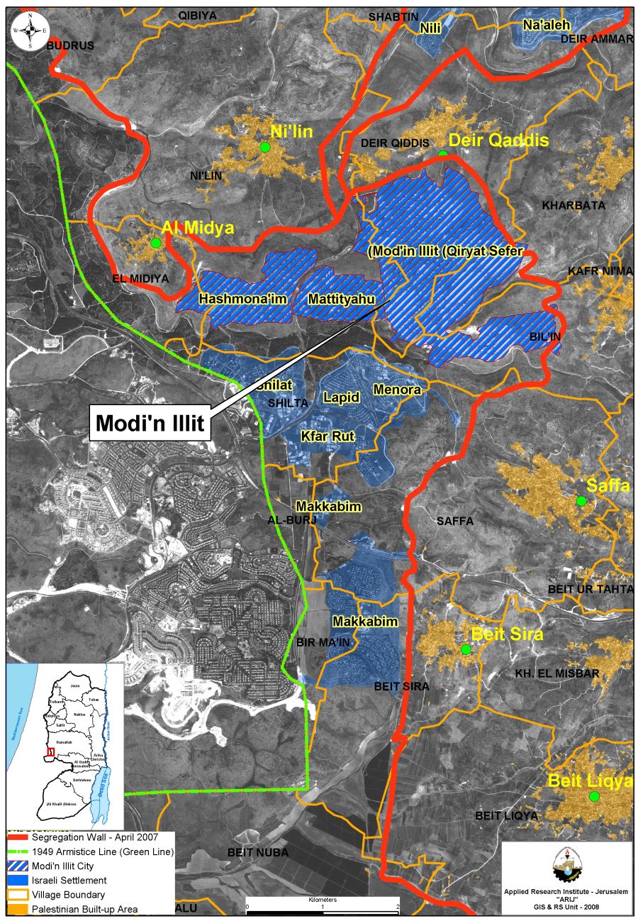
Map 5: The Modi’in Illit settlement Bloc and the Israeli Segregation Wall Plan
Like most of the settlements in the West Bank, Mod’in ‘Illit has a master plan, whose focus is the requisition of Palestinian territories, mostly private owned, to the settlement’s jurisdiction. The Master plan for this bloc will expand the area of the bloc in all direction onto Palestinian privately owned lands from the aforementioned villages. The master plan “provides a forecast for the year 2020, by which time the Mod’in ‘Illit bloc will have 25,000 housing units and 150,000 residents. The total land area of the plan, including roads, is 17,302 dunams, forty percent of which are for residential use, fifteen percent for public buildings, and open spaces, and six percent for roads.”[Moreover, this is to be done without any consideration for borders between the minor settlements, while it will integrate the other three settlements into the new Mod’in ‘Illit master bloc. The new bloc will have more power and authority over all neighboring Palestinian lands. A bloc of this size is simply not meant to be given up by Israel.
The Civil Administration made this plan a precedent in the connection between the Wall and the plans for settlement expansion. It became evident through the facts on the ground that the course of the Wall was built to be compatible with the previous master plan. Evidence on this can be found in numerous aerial photos, but most importantly through the state’s admitting, “that these […] plans were taken into account in setting the route” and requisition orders that include Palestinian lands which unapproved expansion plans include. These plans have not gone through uninterrupted; for many topographic and logistics threats and details derailed the original rout of the Wall. As a result, these interests will contain this whole area into the “Israeli” side of the Wall. Accounting for this master plan must raise questions about the attention, or lack thereof, that Israel has paid to the effect that building the Wall here will have on the lives of the Palestinians who live in their villages near by. As a result of their disposition for the benefit of the settlements, and later the building of the Wall, the Palestinians living in the neighboring villages will lose thousands of dunams of fertile farming and grazing land.
The situation that is developing in Mod’in ‘Illit is an example of the livelihood and historical lands of the indigenous Palestinians being confiscated for the sake of the interests of real-estate developers. This is because since the route of the Wall only saw minor changes due to alleged security threats, the question of the Wall existing out of military necessity is rather irrelevant. The matters in question here are those of economic and simple political value alone, not security. All Israeli governments have gone out of their ways to emphasize the importance of the settlements to them, as a part of political agenda. Moreover, this case also suggests that Israel sees that investment in the West Bank is worth absorbing some criticism, no matter from whom, for. is an example of the livelihood and historical lands of the indigenous Palestinians being confiscated for the sake of the interests of real-estate developers. This is because since the route of the Wall only saw minor changes due to alleged security threats, the question of the Wall existing out of military necessity is rather irrelevant. The matters in question here are those of economic and simple political value alone, not security. All Israeli governments have gone out of their ways to emphasize the importance of the settlements to them, as a part of political agenda. Moreover, this case also suggests that Israel sees that investment in the West Bank is worth absorbing some criticism, no matter from whom, for.
The case of road 443, near the Mod’in ‘Illit bloc, suggests similar results. The road was constructed after the occupation of the West Bank in 1967. It connected roads from Jerusalem to Tel Aviv, while passing through the area of Mod’in ‘Illit. The case of building this road was contended in front of the High Court as it confiscated Palestinian lands. The formal reasoning was that this road was meant to meet the Palestinian villagers’ needs, thus, the road would pass through, or near, several villages. The road became, as a result, the main means for 35,000 Palestinians to reach Ramallah and the rest of the West Bank. This came in the stead of a multitude of worn out road that were becoming less reliable as the number of automobiles increased dramatically in the West Bank. However, the army admitted the court that Israeli settlers and military personnel used the road as well, which means that it is automatically under total Israeli control. This made way for Israeli restrictions on the Palestinian use of the road, where they handled issuing tickets and enforcing prohibitions with, or without, basis. It also made way for preferential treatment that favors the Israeli users of the road, although it was built in its totality on Palestinian lands. , near the Mod’in ‘Illit bloc, suggests similar results. The road was constructed after the occupation of the West Bank in 1967. It connected roads from Jerusalem to Tel Aviv, while passing through the area of Mod’in ‘Illit. The case of building this road was contended in front of the High Court as it confiscated Palestinian lands. The formal reasoning was that this road was meant to meet the Palestinian villagers’ needs, thus, the road would pass through, or near, several villages. The road became, as a result, the main means for 35,000 Palestinians to reach Ramallah and the rest of the West Bank. This came in the stead of a multitude of worn out road that were becoming less reliable as the number of automobiles increased dramatically in the West Bank. However, the army admitted the court that Israeli settlers and military personnel used the road as well, which means that it is automatically under total Israeli control. This made way for Israeli restrictions on the Palestinian use of the road, where they handled issuing tickets and enforcing prohibitions with, or without, basis. It also made way for preferential treatment that favors the Israeli users of the road, although it was built in its totality on Palestinian lands.
After attacks on Israeli cars using the road, the Israeli army unilaterally decided to close the road in front of Palestinian traffic. The move was legally noteworthy because no official military order was made, however, on the ground. The road, instead, was closed with regular military patrols, checkpoints, iron gates, watchtowers and roadblocks. This meant that the Israeli High Court of Justice would be obliged to treat the case rather differently. As a result, Palestinians were forced to use unfinished or unpaved roads to get to their farmlands, on the other side of the road, or get to Ramallah and the rest of the West Bank. The new process meant that Palestinians would have to spend 45 extra minutes to an hour to reach their farmland, a journey that needed 10 minutes to be completed using the 443 road. This is not to mention the economic burden that this puts on the villagers. Villagers depend on traveling to Ramallah, the largest economical center in the area, for their livelihood. The closure of the road not only meant that reaching their destinations took longer and became less convenient, but also made it impossible at times to reach these destinations. On the other hand, Israel could have prohibited the use of 443 by Israelis if it were so concerned for their safety. Israel, however, has proven that it values the convenience of settlers over the livelihood of the Palestinians. . This is not to mention the economic burden that this puts on the villagers. Villagers depend on traveling to Ramallah, the largest economical center in the area, for their livelihood. The closure of the road not only meant that reaching their destinations took longer and became less convenient, but also made it impossible at times to reach these destinations. On the other hand, Israel could have prohibited the use of 443 by Israelis if it were so concerned for their safety. Israel, however, has proven that it values the convenience of settlers over the livelihood of the Palestinians.
The road used Palestinian private owned lands for its construction, but perhaps more importantly it meant that it would limit access to other lands on either side. Road 443 is 17 kilometers long and it is build solely on private Palestinian land. This means under international law that it cannot be closed, for this closure poses a restriction on their freedom of movement in the territory that they live in legally. is 17 kilometers long and it is build solely on private Palestinian land. This means under international law that it cannot be closed, for this closure poses a restriction on their freedom of movement in the territory that they live in legally.The result of the Israel actions meant that it became a part of the settler-only, illegal, bypass road network in the West Bank. Israel then began constructing a new road to serve in 443’s stead, which would have taken away even more private Palestinian lands from the villagers.
The economic burden that this puts on the villagers is immense. Villagers depend on traveling to Ramallah, the largest economical center in the area, for their livelihood. The closure of the road not only meant that reaching their destinations took longer and became less convenient, but also made it impossible at times to reach these destinations. Instead of using their private cars farmers were forced to use public transportation, which is a more expensive means. Using this new route and new means of transportation put their corps in jeopardy of rotting while in transit for the procedures of passing through check points always entail waiting in long lines to get through. It also meant that these villagers, who are farmers in their overwhelming majority, lose more of their farmland for the sake of these new roads. Furthermore, “100 small shops in villages along its route have closed, among them floor-tile establishments, flower shops, furniture stores, and restaurants.” This was devastating to the local economy in the villages. This is not to mention the intangible effect of this case on the relations the villagers have with Ramallah, where many of their relatives live, and a tangible effect that the situation have on their access to social services, emergency services, and hospitals that are only available in the big city.
In the village of Saffa, 250 dunams of Palestinian land were taken to build the Wall to protect the settlements, “the trees were uprooted and land leveled”. This part of the Wall was built to surround the settlement of Menora, a part of the Mod’in ‘Illit bloc. It enclaves 2,100 dunams of privately owned Palestinian land that was estimated to make half a million shekels a year worth of olive oil alone. Most of this land is to be used for expansion plans of the settlement; some are not even approved plans. The loss that the villagers face is irreplaceable. 33 percent of the village’s land is now “harmed” by the existence of the settlement, bypass roads and the Wall. B’Tselem writes: “Israel is expected to declare the area between [the Wall] and the Green Line a closed military area […] From that moment, Palestinians will be allowed access to their land west of the barrier only if they have an entry permit from the Civil Administration, which is contingent on a GSS finding there are no security reasons to refuse granting the permit, and subject to the resident proving ownership of land in the closed area. Based on past experience, some Palestinians will be denied all access to their land.” Permits, however, do not solve the problems that are most pressing in the villages. Permits still do not allow construction, which is one of the pressing losses that occur with loss of the land, nor do they allow their holder to let their livestock graze in their land on the west side of the Wall. This results in the migration of the villagers from their lands, and to them reconsidering their dependency on livestock for their livelihood.
Sadly, as B’Tselem notes, this might be the least of the villagers’ problems. Previous experiences and current evidence point to the inevitable outcome of the Wall’s placement. That is to say that most of these lands will end up being construction sites for the settlers of Menora.
“Ethnic cleansing”, as a term, has been used to describe the actions against Palestinians before, during and even after the 1948 war. This was a case of a military power systematically killing, imprisoning and throwing a group of indigenous people out of their homes based solely on their ethnicity. Although it cannot be mistaken for any classical, or textbook, case of ethnic cleansing as the international community defines it, the treatment of Israel in the West Bank near the Wall has to be considered a somewhat similar action. Israel instead of taking over the houses of all Palestinians in villages near the Wall, systemically controls their lands and livelihoods, which ultimately makes leaving the territory the only viable option for Palestinians. The Israeli settlements, Wall, bypass roads and permit system limits options so severely in the eyes of the Palestinian youth forcing them to abandon their villages and lands, in order to look for their right of life, liberty and the pursuit of happiness elsewhere.
The events in border villages are very similar to each other, almost to a suspicion raising degree. After the seizure of 25 dunams of his 30 and throwing him into poverty Suliman Yassin, 69, of neighboring Bil’in said in 2005: ‘Not only has the fence damaged our livelihood, it also destroyed our privacy. […] cameras document every movement and everything that happens near the fence. My house lies very close to the fence […] I feel humiliated and harassed all the time, and I don’t know what to do.’
The villagers of Al Burj, Saffa, Kharbatha El Misbah, Beit ‘Ur El Tahta, Beit ‘Ur El Fuqa and Beituniya filed a petition in front of the Israeli High Court in order to be allowed to return to using the road 443. The case remained in front of the Court for 29 months. Finally, the Court ordered the army on the 29th of December 2009 to open the road for the use of Palestinian by the end of a five-month preparatory period. The villagers of Beituniya seem to be doomed to carry most of the burden of this order. The army carries out the deployment of such orders in the West Bank, as a result the army decided that certain protective measures were to be deployed before the road is opened for Palestinians. The military administration of “Judea and Samaria” ordered the confiscation of 173 dunams of private Palestinian lands in the area. The reason was the building of the ‘Ofar crossing point to control and monitor the movement of Palestinians on the road 443 and to build a protective Wall around the road. The lands confiscated were, in fact, 284 in total area for those purposes, which will destroy and confiscate more lands while further complicating the lives of the villagers. This means that instead of closing the road informally, it is now closed in front of “only” most of the Palestinian traffic, except for those who are allowed through the new checkpoint.
Economic collapse in the Palestinian countryside is becoming rather inevitable as a result of settlements and the extents Israel is willing to go to in order to protect their economic, political and, least of all, security interests. In order to protect real-estate developers and the Israelis from using roads inside the green line tens of the thousands of Palestinians are forced to alter the basic components of their live and livelihood.
The Settlement of Zufin (Tzufim):
The settlement of Zufin lies on 622 dunams of the lands of the district of Qalqilya. It is home to 1,143 settlers. The settlement’s jurisdictions covers, thus effectively controls, approximately 2000 dunams, most of which are on the lands of the village of Jayyus. Like most cases in settlements in the West Bank it is hard to identify how much are the dwelling cost for a housing unit in this settlements. However, it is impossible to know, and most of all for a Palestinian, the exact costs of security, maintenance and most importantly the costs, to the state, for financial incentives that drive some settlers to reside in such settlements. On the other hand, if we recognize the plans to protect this settlement, it might present an idea of the extent to which it costs Palestinians for such settlements to exist.
Much like most settlements near the Green Line, Zufin is now included into the “Israeli” side of the Wall. This is despite that the settlement in its entirety is on the Palestinian side of the Wall. The inclusion of this settlement into the Israeli side was faced with rather straightforward Israeli reasoning. The State Attorney’s Office explicitly admitted that the plan expanding the settlement was in fact taken into account while determining the route of the Wall around the area. This is a very different methodology than that normally employed by the oft-discreet officials. Israeli officials tend to relate the inclusion of such areas to security imperatives or difficulties to find alternatives. This rather easy to see through the facts on the ground as well; this is to say that the existing of any separation between the Wall and the borders of the settlement cannot be used for further build-up. This “warning area” is meant to separate the Wall from the settlements; hence, other areas need to be confiscated for further build-up, which is what happened. As a result, the built up area was effectively accounted for twice. Israel, similarly, took a rather unfavorable topographical route for the Wall in order to capture more lands, which drove the Wall closer to the houses of the Jayyus village. B’Tselem, reports that other routes could be used that drove the Wall farther from Jayyus and that are topographically more suitable. The new route would not pass through low areas that defeat the purpose of having a nine-meter high Wall in the middle of the heavily populated lands. However, and rather characteristically, Israel refuses to build the Wall unless it is in allocation that guarantees it more economical and political benefits.
Zufin, and by association the part of the Wall that surround it, present an indicative example of life along side settlements. All of the settlement’s lands, as well as the lands used to building the Wall and the ‘warning zone”, were taken from Palestinian lands that belonged to the villagers of Jayyus. Of more concern to the villagers’ future is that this new situation denies them access to the remains of their farmlands on the western side of the Wall. This land amounts to 8500 dunams or 70 percent of Jayyus’ villagers’ lands, an overwhelming majority of which belongs to farmers, who depend almost entirely on agriculture, in this land, for income.
Israel tried to respond to the uproar concerning this very issue through giving Palestinians entry permits. This is limited to those who prove, to the army’s satisfaction, that their land is inaccessible due to the Wall. However, the army refuses applicant often. In the six months following October 2003, 273 requests for permits were rejected. For comparison sake, since then 541 were issued in total, while 20 remain refused. These refusals are based on varied criteria; such as security threats and the absence of “valid” documentation for the ownership of the land. On the other hand, this criterion is extremely subjective; it is applied by the army, which results in making the day-to-day refusals and acceptance extremely difficult to contend. That is reflected in the appeal systems that are applied on the ground. Although the owners can appeal their request refusals, they are not entitled to appear before the committee to present their cases. Worst of all, owners who are refused permits are not entitled any compensation for their losses due to these restrictions. The only solution to some cases was to approach the Israeli High Court, whose ruling was the cause behind the drop in the rate of permit refusals. Regrettably, this judicial system is foreign, alien, difficult to maneuver and expensive for the Palestinian farmers who are poor to begin with.
Ironically enough, when Israel decides to grant permits for the entry of the “seam zone” it is often a way of concealing the underlined its intentions. Israel intends to make it impossible for Palestinians to cultivate their lands in the zone, even for those who have permits. In a testimony to B’Tselem, ‘Itaf Ahmad Sa’id Khaled, a resident of Jayyus said in November 2005, regarding her land that is now on the west side of the Wall: “I am fifty-seven years old and married… We have twenty-two dunams of land situated west of the separation fence. Since 1989, I have helped work this land. The crops we grow are the sole source of our family’s livelihood. All of us were involved in the farming…My husband, our sons, and I received permits to pass through one specific gate [in the wall] to get to our land. In January 2005, my husband submitted requests to the DCO in Qedumim to renew all our permits. The requests for my husband and the boys were rejected, and I was given a six-month permit. They resubmitted their requests several times, the last being this month [November]. All were rejected.”
“… I am unable to work the land by myself… My husband had to get a farmer with a permit to cross the fence, and make an agreement with him to work our land. As payment, the farmer gets one-third of the crop [about NIS 40,000]. But you can’t compare the quality of care given to the land – it is much greater when the person working the land is the owner.”
There is also a logistical side to the permit system that is crippling to the Palestinians villagers. The only way to access the lands, for Palestinians with permits, is through staffed gates that are located in certain areas along the Wall, which only operate in specific hours. This, as we have seen earlier, increases travel times and expenses, not to mention the inherent limitations on grazing, cultivation and times of access placed by the system. This is not only to say that the distances are artificially increased, but also due to wait times on gates, and their closure times, the process of using them is draining in a less tangible way. For instance; only two agricultural gates serve all the villagers of Jayyus who are roughly 3700 people.
The president of the High Court, Aharon Barak, quoted by B’etslem said of this particular situation.
This state of affairs injures the farmers severely, as access to their lands (early in the morning, in the afternoon, and in the evening), will be subject to restrictions inherent to a system of licensing. Such a system will result in long lines for the passage of the farmers themselves; it will make the passage of vehicles (which themselves require licensing and examination) difficult, and will distance the farmer from his lands (since only two daytime gates are planned for the entire length of this segment of the route). As a result, the life of the farmer will change completely in caparison to his previous life. The route of the separation fence severely violates their right of property and their freedom of movement. Their livelihood is severely impaired. The difficult reality of life from which they have suffered (due, for example, to high unemployment in that area) will only become more severe.
The Settlement of Alfe Menashe:
Alfe Menashe stretches over the 2900 dunams of land in the villages of Habla and Azzun. It has a population of over 6600 settlers. Nonetheless this is the least harm that the settlement’s existence has caused. Israel admitted, when building the Wall in the area, that the plans for the expansion of the settlement, not simply its security interests, took a central role in determining the route of the Wall. This remains a very interesting case, however, since officially, until 2010, the original route and construction of the Wall put the villages around Alfe Menashe in an enclave, namely a-Dab’a and Ras a-Tira. This meant that they were separated from all directions from the rest of the West Bank save for a staffed gate, to which they had limited access.
The villagers were given special permits in order to leave the enclave for the West Bank. Needless to say though, that this limited their freedom of movement and expansion. This becomes even more important when we realize that the surrounded villages are very small, which means that they depend, almost entirely, in their livelihood and basic daily needs on their access to bigger economic centers in Qalqiliya and Habla. This, of course, takes no notice of the family bonds that these villagers share with most of the villages that they are now separated from.
Resident of the area, who wished to remain so, were required to acquire special resident-of-the-seam-area cards that were the only way for them to reach the rest of the West Bank. These cards allowed the villagers to “pass through a gate in the barrier, at which they must wait in line, show their permit, and undergo a physical check.” This process is, by definition, a time consuming one. This process is, more importantly and by social standards and humanitarian law, degrading and unbecoming. However, villagers could not avoid going through this for they are forced to leave the enclave to purchase goods and sell their products. It is also essential to recognize the effect of the situation from a health prospective; that is that there is not a single Palestinian doctor in the enclave. In close connection, the WHO reported in June 2010 that “the Barta’a enclave [that has] 5,600 inhabitants, was visited twice a week by a mobile health team from UNRWA: however, since September 2007, UNRWA has been unable to access Barta’a [because of the Israeli restrictions] and the programs have been suspended.” Which adds to the crises that starts with the inability of Palestinian doctors to enter the enclave any more.
Similarly, the movement of cars was limited; only the owners of the cars were allowed to pass the gate while driving them. As a result, all Palestinians have to account for the times that the gates open, because there are no expansions as to this particular schedule. This system is, perhaps, best described, quite literally, through school schedules. The gates in the Wall were, at some point, open only three times a day primary to allow children to go to school in Habla. This might seem outrageous at first glance, however until a set period of time was designated, this was the way the schedule was set.
In 2010, the High Court ordered the reassignment of the route of the Wall to go around the villages and integrate them back into the West Bank. This is a welcome decision for the villagers, however it remains well overdue, not to mention without compensation. The villagers, through the past 5 years or so, were forced to sell all greenhouses at a loss, because they could not reach them through the Wall. They were forced for 5 years to go through grueling walking distances in order to make trips that took them little to no time to complete before the Wall. Villagers, as a result of the new decision, lost most of their private lands north of their villages. This means that the Wall now simply still separates the villagers from their livelihood just in different whereabouts. Nonetheless, the High Court’s decisions are installed on the ground through the army in the West Bank. This has meant, previously, that some orders are not followed thoroughly mainly because of special “military arrangements”. In Ni’lin, as in Kherbet Jabara and road 443 as previously mentioned, the army treated the High Court orders as mere suggestions. Although the orders were to completely change the route of the Wall in those areas, the army, because of military “necessities” made only minimal changes, which ultimately did not alter the negative impact that the Wall had on the villagers in the first place.
The Future:
Through 43 years of occupying the West Bank, the process was never a partisan one. The first prime ministers to order the commencement of the process were considered leftists and from the Labor party. However, the increased influence of the likes of Avigdor Lieberman is not an encouraging factor pointing towards the future. Large settlements are being planned and built as you read this. Lieberman’s party won 15 seats in the last Kenesset elections, which are four seats more than the Labor party. This was unheard of even five years ago. This extreme political climate only allows for more fundamentalists to seek and seize control, which has led historically to more settlement expansion in the West Bank and strengthening of the already existent settlements.
The settlement of Ma’le Adumim is only one. This settlement is simply massive. It is constructed in its totality on Palestinian West Bank land. It is 11.5 times the size of all the Palestinian villages surrounding it combined, making it larger in area than Tel Aviv. This monstrous size houses 33000 thousand settlers; this, in comparison, is 50 percent less than the population of the neighboring villages. This settlement has grown at a stifling rate; it has doubled in size in the last 16 years, an 18 thousand-person increase. Ma’ale Adummim is different from Tel Aviv in population for it houses less than ten percent of the 400 thousand inhabitants of the costal city. This is in all regard an indication to the direction and purpose of this settlement, and all other settlements, in the West Bank. These settlements do not simply solve a problem of housing, they are meant to control as large an area of the West Bank as possible, while separating as many Palestinians from their lands and each other as much as possible.
Continuing the trend in 2009, before the freeze, there were 509 housing starts in the settlements of the West Bank, in addition to 508 in the settlement in East Jerusalem. This represents one quarter of all Israeli government construction that year. Not to mention that there were 200 privately built apartments sold in the West Bank. After November 2009, there were 423 violations in the West Bank alone. Although this seems to be rather normal in a situation as polarizing as that in the settlements, this remains a rather unsettling fact. This is because the state does not generally enforce the law against illegal construction in the settlements, which means that most of the new constructions will remain. The absence of punishment must raise questions as to the seriousness of the state about enforcing the law, when this enforcement benefits Palestinians.
New cases emerge daily, nonetheless. Near Bethlehem the plans of the largest single settlement to date are being approved, namely the plans for Giva’t Yael. The settlement will do its job of finding 55,000 Jewish immigrants new houses in the Occupied West Bank. Moreover, it will do its most important job through connecting Har Gilo and Gilo into a strip that isolates Jerusalem from the southern West Bank completely, while confiscating more lands from the town of Walaja. Giva’t Yael is only the last settlement of this size to be approved and there remain no signs that Israel is slowing down.
The crisis remains. OCHA reported in 2010: “nearly 40% of the Palestinian population is food-insecure. Most Palestinians cannot exercise their basic human rights to free movement, employment, basic services, and self-determination” Most of this is the result of the settlements and the restriction that Israel places on Palestinians to keep them.
The Freeze is not the solution, especially in its current form, where it is a part of the problem. The solution is not even a permanent stoppage of building settlements, nor is it the new “Fabric Of Life” plans to ease the situation for Palestinians and normalize the occupation. The solution remains in the evacuation of these settlements, nothing more but nothing less. This does not mean a procedure like that in Gaza. “In 2005, despite the positive climate that prevailed following the evacuation of around 8,000 Israeli settlers from settlements in the Gaza Strip and northern West Bank, poverty worsened. Sixty-four percent of the Palestinian population lives in poverty with 32 percent living in acute poverty.”[ This information, although relatively outdated, is crucial to understanding and underlining the effects of the Israeli version of disengagement. The Israeli army still controlled all entrances of Gaza and limited its supplies and rare exports, while clearing itself from the responsibility of any ramification to this policy. On the other hand, this dip in the quality of life does not mean that the Gaza economy was built on exporting to Israeli markets and it collapsed as a simple ramification of the Siege. However, it means that under the Israeli set rules of the process, the Palestinians are to live in cartons that are controlled from all sides. This happens simultaneously while every aspect of a healthy economy in the OPT, after the disengagement, is destroyed, or in the best cases, crippled. If settlements are not evacuated properly, without any other agenda, they will remain a burden on the fragile system of resources in the West Bank, while remaining an obstacle in the face of Palestinian unity and statehood.
::::::::::::::::_
* Here thereafter the term “settlements in the West Bank” will follow the international law definition that includes settlements in East Jerusalem as part of those in the West Bank (unless otherwise stated).
[1] Article 49 of the fourth Geneva convention
[2] Land Grab (B’Tselem, 2002)
[3] ARIJ, During the preparation of this paper, B’Tselem published a work citing only 121 settlements. This is the first time B’Tselem fails to recognize the rest of the settlements in the West Bank.
[4] The “state” will refer to Israel in this work.
[5] Unmaking Palestine
[6] “Foul Play: Neglect of Wastewater Treatment in the West Bank”. B’Tselem, 2009
[7] ARIJ
[8] “Foul Play: Neglect of Wastewater Treatment in the West Bank”. B’Tselem, 2009
[9] “Foul Play: Neglect of Wastewater Treatment in the West Bank”. B’Tselem, 2009
[10] ARIJ
[11] B’Tselem, Annual Report 2010.
[12] Under the Guise of Security, B’Tselem, 2006
[13] Under the Guise of Security, B’Tselem, 2006
[14] Implementation of the master plan is to be done in three stages. The first stage, which is to be completed by 2005, calls for 9,000 housing units. Stages 2 and 3, which are to be completed by 2012 and 2019 respectively, call for the construction of 16,000 housing units.[ From source] (Under the Guise of Security, B’Tselem, 2006)
[15] ARIJ
[16] ARIJ
[17] Under the Guise of Security, B’Tselem, 2006
[18] “The testimony was given to Iyad Haddad at the witness’s house on 20 July 2005.” [From source] Under the Guise of Security, B’Tselem, 2006
[19] OCHA, Annual report, 2009
Prepared by:


