Violation: expropriating 24 extra dunums ( one dunum equals 1000 M2)
Date: January 14, 2010.
Violators: Revava colonists
Victims: The family of the Deceased Yousuf al Samhan from Deir Istiya, Salfit governorate .

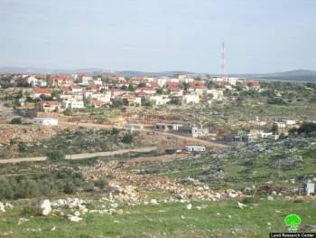
Picure 1: Revava Colony
Details:
In the morning of Thursday January 14, 2010, colonists from Revava colony started fencing and plowing an estimated 24 dunums of farm land located to the east of the colony. Deir Istiya residents grouped immediately and demonstrated against the plowings. Soon the demonstration turned into a clash with the Israeli Occupation Army soldiers and the colonists.
Soon afterwards, soldiers tried to drive the colonists back in order to avoid the press since many Israeli Occupation officials claim that all colonial activities in the west bank are frozen. The colonists' actions simply confirm the false allegations made by many of the Israeli Occupation officials, who claimed that the colonization activities in the west bank were 'temporarily frozen'.
The Israeli Occupation is trying to clear its reputation before the western world, especially its strategic ally, the USA. These false allegations provided the Israeli Occupation the cover and the support it needed for its outrageous exploits in the West Bank, especially what is happening in the Occupied City of Jerusalem. Furthermore, colonies have never stopped expansion, which is being carried out now under the pretext of 'natural growth requirements'.
On Sunday, January 17, 2009, colonists protected by the Israeli Occupation Police restarted their plowings in the area. A step taken towards occupying as much land as possible. Palestinians were forbidden from exploiting or even reaching their lands because the Israeli Authorities categorize it as 'nature reserve'.
Revava Colony:
Revava colony, which is built on the lands of the Palestinian village of Deir Istiya, is witnessing huge expansions. Tens of residential units are being constructed, in addition, many mobile caravans ( mobile homes) have been placed around the colony.
It is obvious that these are steps towards increasing the capacity of the colony and eventually increase its population. Furthermore, a Jewish Synagogue is being built in the colony.
Revava colony was established in 1991, its built up area is around 160 dunums and its municipal area is 1540 dunums while its settler population by the end of 2008 was 1075 colonistsز
The colony, like its counterparts, contributes in devouring the Palestinian lands for the sake of colonial expansions. Moreover, the Israeli Occupation Authorities and the colonists do not show any sign of respect to the international laws concerned with the measures of disposing different types of waste. Simply, the colonists dump their waste (any type of waste) near the Palestinian villages which is extremely hazardous to the environment.
Deir Istiya:
It is located 7 km away from Salfit City, and 25 km away from Nablus City. It is placed under Salfit Governorate jurisdiction. A side road connects the village to the main road in the area, Nablus- Jerusalem road. It is surrounded by different Palestinian villages including Zeta, Kafl Haris, Haris, Amatin, 'Azzun, Qarawat Bani Hassan, Biddya, and others.
The village is inhabited by 3146 people. Most of the locals have jobs in the private or public sectors. In addition, many of them depend on agriculture. The total area of Deir Istiya is 34592 dunums. Its total built up area is around 640 dunums.
The Israeli Occupation expropriated 4034 dunums that were used for colonial expansion purposes. Many colonies were established in the area including Ariel, Yakir, Revava, Emanuel, and many others.
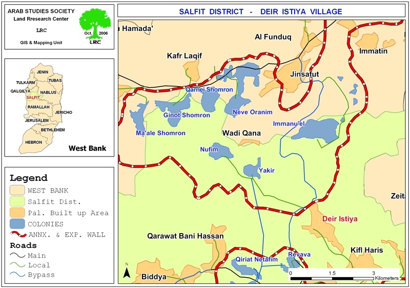
Table 1: land usage:
|
Usage |
Area |
|
Old Town |
65 |
|
Olive trees |
6969 |
|
Fig |
175 |
|
prunus |
44 |
|
Citrus |
500 |
|
Grazing |
30000 |
Table 2: Colonies built on the lands of Salfit:
|
Name |
Type |
Establishment Date |
TotalArea |
Built-up Area |
Inhabitants (2005) |
villages expropriated |
|
Ariel |
Residential, educational, military |
1978 |
13775 |
2479 |
16520 |
Salfit, Kafl Haris, Marda, Deir Istiya |
|
Immanuel |
Residential |
1982 |
1909 |
328 |
2585 |
Deir Istiya |
|
Yakir |
Residential |
1981 |
1364 |
342 |
984 |
Deir Istiya |
|
Nofim |
Residential |
N.A. |
331 |
248 |
400 |
Deir Istiya |
|
Karne Shomron |
Residential, industrial |
1978 |
7339 |
1351 |
6280 |
Deir Istiya |
|
Ma'ale Shamron |
Residential |
1980 |
1903 |
216 |
574 |
Deir Istiya |
|
Ginnot Shomeron |
Residential |
1985 |
N.A. |
608 |
N.A. |
Deir Istiya |
|
Revava |
Residential |
1991 |
1540 |
160 |
827 |
Haris |
|
Kefar Tapuh |
Residential, military |
1978 |
414 |
156 |
648 |
Yasuf |
|
Bedo'el |
residential |
1984 |
595 |
171 |
1113 |
Kafr ad Dik, Deir Ballut |
|
Kiryat Netafim |
Residential |
1982 |
1540 |
162 |
438 |
Qarawa, Haris, |
|
Alei Zahav |
residential |
1982 |
2003 |
255 |
684 |
Kafr ad Dik |
|
Elqana |
Residential |
1977 |
1198 |
758 |
2963 |
Mes-ha |
|
Shaare Tikva |
Residential |
1982 |
1045 |
915 |
3709 |
Mes-ha, 'Azzun 'Atma |
|
'Etzfraym |
Residential |
1985 |
458 |
184 |
642 |
Mes-ha, Beit Amin, Seniriya |
|
Albarqan |
Residential, industrial |
1981 |
2720 |
349 |
1231 |
Sarta, Bruqin, Haris |
|
Neve Oranim |
Residential |
1991 |
N.A. |
153 |
N.A. |
Deir Istiya |
|
Total |
38134 |
8835 |
39569 |
|
||
:::::::::::::::_
[1] Foundation for Middle East Peace- Washington DC, statistical report for 2008
[2] Deir Istiya village council
[3]– Field research and GIS units in LRC
– Foundation for Middle East Peace Washington
Prepared by
The Land Research Center
LRC