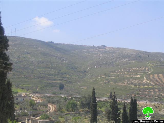
The colonists of Barakha, located on Al Tur Mountain northeast of the village of Burin, began plowing and expansion work of the colony in April 2009. The plowing took place in Khallet Nofal southeast of the colony over an area of 250 dunums. The targeted lands are owned by 8 Palestinian farmers who were not able to reach it since the colony came to existence due to its location overlooking the colony. The 8 farmers are Mr. Mohammad Adnan Al Najjar, Mr. Fuad Salem Atiyya Al Najjar, Mustafa Sidqi Zein, Mr. Salman Adli Qadoos, Mr. Fuad Saleh Najeed Zein in addition to the heirs of Mr. Abdullah Jaber Al Najjar.
It is worth pointing out here that Israeli occupation soldiers do not spare any effort to attack Palestinian farmers and herders of the village of Burin under the pretext of preserving the security of the colony.
In terms of trends, the northern parts of the West Bank are witnessing a noticeable escalation in the expansion of existing colonies in addition to the establishment of new outposts especially in the aftermath of the election of the Israeli right to hold and steer the government in Israel. The colony of Barakha is at the forefront of colonial expansion in the northern parts of the West Bank along with the outpost of Gila’ad Zoher located east of the city of Qalqilia.

Photo 1: Land plowing for the purpose of the expansion of the colony of Barakha.
Also of note is the increased frequency of attacks carried out by colonists against Palestinians living in the vicinity of the colonies. The village of Burin is a prime example of such suffering as attacks carried out by colonists included the burning of trees and Palestinian farms especially in the past 8 months as thousands of citrus and olive trees were set ablaze by Barakha colonist. For additional information please press here.
It is worthy to note that Israeli colonists burnt the lands of the village three consecutive times in 2008; on November 14th, 2008 more than 700 dunums containing more than 9500 olive and other type of trees were set ablaze by Israeli colonists. The fire raged for more than 5 hours. The same scene was repeated earlier on the 31st of May, 2009 and on the 17th of June, 2008, when Israeli colonists set fire to 4,000 olive trees in the village of Burin owned by Mr. Ghaleb Qasem Najjar and Mr. Abdel Jabbar Hasan Najjar.
Mr. Hussein Abdel Lattif Najjar (age: 58) from the village of Burin is considered to be an example of the suffering of Burin villagers especially those owning agricultural lands located in the vicinity of the colonies. Mr. Najjar expressed the following:
The Israeli colonies of Yetzhar (established in 1984) and Barakha (established in 1987) confiscated more than 7,000 dunums of Burin lands. Colonists from these two colonies chose the olive harvest season to burn Palestinian farmer lands. The last fire affected more than 150 farmers with losses exceeding more than 1.5 million dollars
Yet, the attacks and violations committed by the colonists from these two colonies did not stop at burning and destroying Palestinian lands. Rather, it continued to reach Palestinian homes as colonists attacked the house of Mr. Saeed Mahmoud Al Najjar at midnight of one of November 2008 days. All of the content of the house were destroyed and the house itself was set on fire. The financial losses of Mr. Al Najjar were estimated to be 5,000 Jordanian Dinars. Moreover, colonists attacked and damaged the contents of the houses of Mr. Waleed Saeed Eid and Mr. Ayman Ibrahim Qadoos in July 2008. Also, incidents of beating by colonists of Palestinian farmers and their sheep were reported and documented. The latest such attack took place at the early days of April 2009 when Yetzhar colonists attacked Burin farmers and tried to steal their sheep.
The Village of Burin: General Information
The village of Burin is located 8 kilometers southwest of the city of Nablus. It is also located 2 kilometers away from the Ramallah-Nablus Road. Its surface area is about 19,096 dunums of which 163 are considered by Israeli occupation authorities as ‘State Lands.” The built-up area of the village is 367 dunums while 4,500 dunums are planted with grain and olive trees. Around 13,000 dunums of the villages’ lands are used for Israeli occupational purposes including the afore-mentioned colonies, Ofer military camp (located west of the village) in addition to the colonial bypass road which turned the lives of the villagers to an unbearable nightmare.

According to the latest 2008 population census, the population of the village is around 2800, 70% of which are classified by UNRWA as dependent on its humanitarian assistance provided in cooperation with the World Food Program.
Prepared by:
The Land Research Center
LRC


