
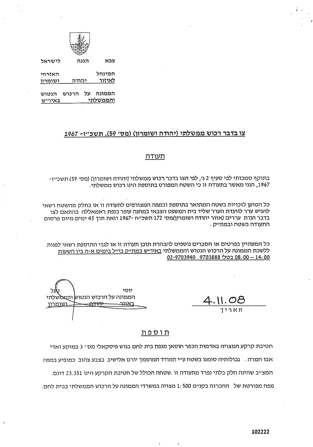
On November 4, 2008, the Israeli Occupation forces handed out Husan village council new Israeli military order issued by the Israeli Custodian of Absentee Land Property of Judea and Samaria in the Israeli Army (Yosi Sigal) to confiscate additional Palestinian lands conducted under the pretext of 'State Property'. The order, given the name 'Order Regarding state property, Judea and Samaria (59), 1967', states the confiscation of 23.351 dunums of Husan village lands, block number 3, in Abu Hamra valley area located alongside the Israeli bypass Road # 375. The order gave Husan Village residents a period of 45 days to file objections to the Israeli Objection Committee at Ofer Israeli Military Court in Ramallah Governorate according to 'Objections Law number 172, Judea and Samaria of 1967' which details the establishment of objections committees to deal with objections related to absentee property (private property) (Military Order 58) and government monies (Military Order 59). See Copy of Military Order
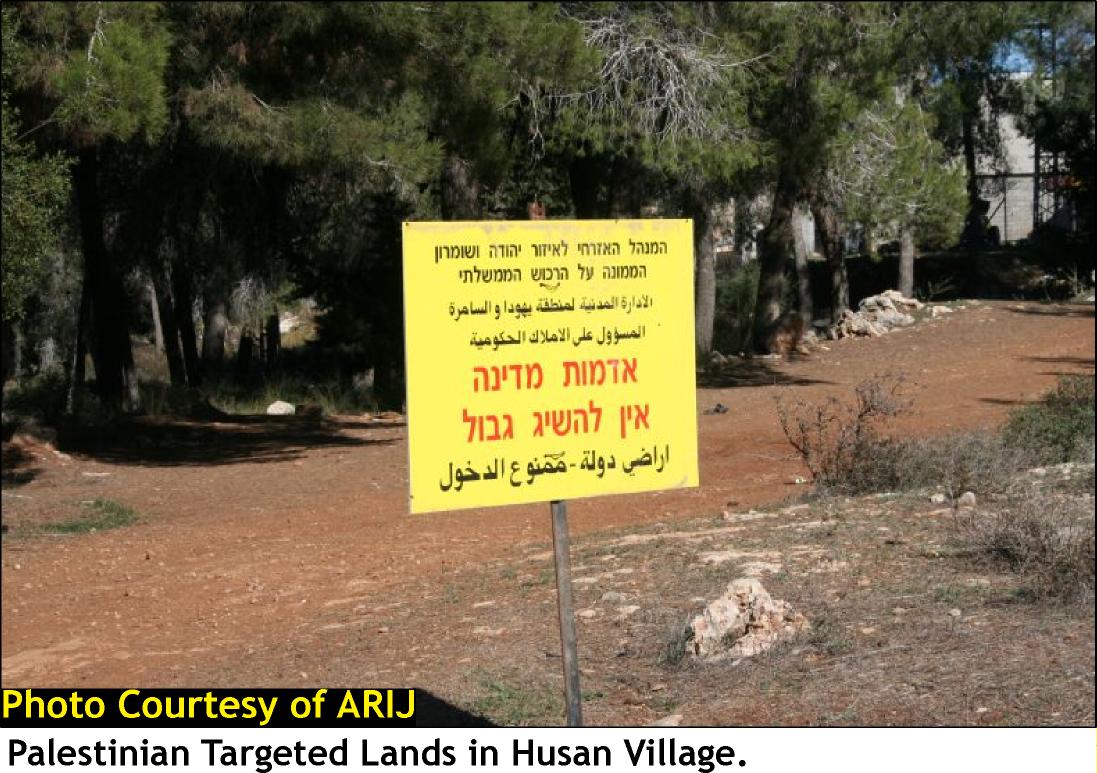
A field trip conducted by ARIJ team to the threatened site showed that a small portion of the threatened site is occupied by an Israeli Gas Station which was illegally established on lands of Husan village in 1992 on a 9 dunums land area at the hands of an Israeli settler living in the nearby Israeli settlement of Betar Ilit. Lands are owned by Hamamreh family and are few kilometers away from the 1949 Armistice Line (Green Line). The remaining portion of land is located to the southwestern side of the Gas Station as shown in the military order map and comes on agricultural lands planted with Olives, Grapes and forest trees in the village. See Map 1


The Israeli occupation forces had paved the way for the confiscation of that portion of land several years ago when they banned Palestinian land owners from accessing their lands located adjacent to the gas station (from its southern site) through the establishment of an Israeli military checkpoint following the outbreak of the second Intifada in September 2000 on the road leading to the lands which in turn has caused a great loss to farmers due to their inability of taking care of their lands and harvesting their crops.
Husan Village: Location and Population
The village of Husan is located some 9 kilometers to the west of Bethlehem city and 2.5 kilometers from the 1949 Armistice Line (Green Line); It is bordered by Battir village from its northeaster side, Al Khader village from the east, the 1949 Armistice Line form the West and Nahhalin village and Betar Illit settlement from the south.
The urban area of the village stands on 292 dunums of land, about 4% of the village's total land area and is a home to 6380 inhabitants (PCBS 2008), most of who tended to work in Agriculture after loosing their jobs as constructional workers inside Israel following the eruption of the second Intifada in September 2000.
The Oslo II Land Classification of Husan Village Lands
In the Oslo II Interim Agreement that was signed in September 1995 between the Palestinians and Israelis, the Palestinian areas in the West Bank were classified into three areas A, B and C which aimed at a phased withdrawal of the Israeli military forces from these areas until the accomplishment of a final status agreement.
Accordingly, the 14794 dunums of Husan Village were classified to areas B and C; 524 Dunums of which were classified as Area B (7.2 % of the total village area) where most of the built up area is concentrated; while the remaining area of the village, a total of 6777 dunums of Husan village lands were classified as Area C (92.8 % of the total village area) and contain all the agricultural lands and the open spaces in the village. See Table 1
|
Table 1: Classification of Lands in Husan village according to Oslo II Agreement of 1995 |
||
|
Classification of Area |
Area in dunums |
% of the Village's total area |
|
Area A |
0 |
0 |
|
Area B |
524 |
7.2 |
|
Area C |
6777 |
92.8 |
|
Total Area |
7295 |
100 |
|
ARIJ GIS Database – 2008 |
||
Series of Israeli Land Confiscation Actions in Husan Village
Husan village has lost a considerable area of its lands for the various Israeli purposes throughout the years of Israeli Occupation. The lands were either used for settlement building and expansion or for the construction of Israeli bypass roads and other related military uses. Below, is a detailed list of all the land seizure actions in Husan Village:
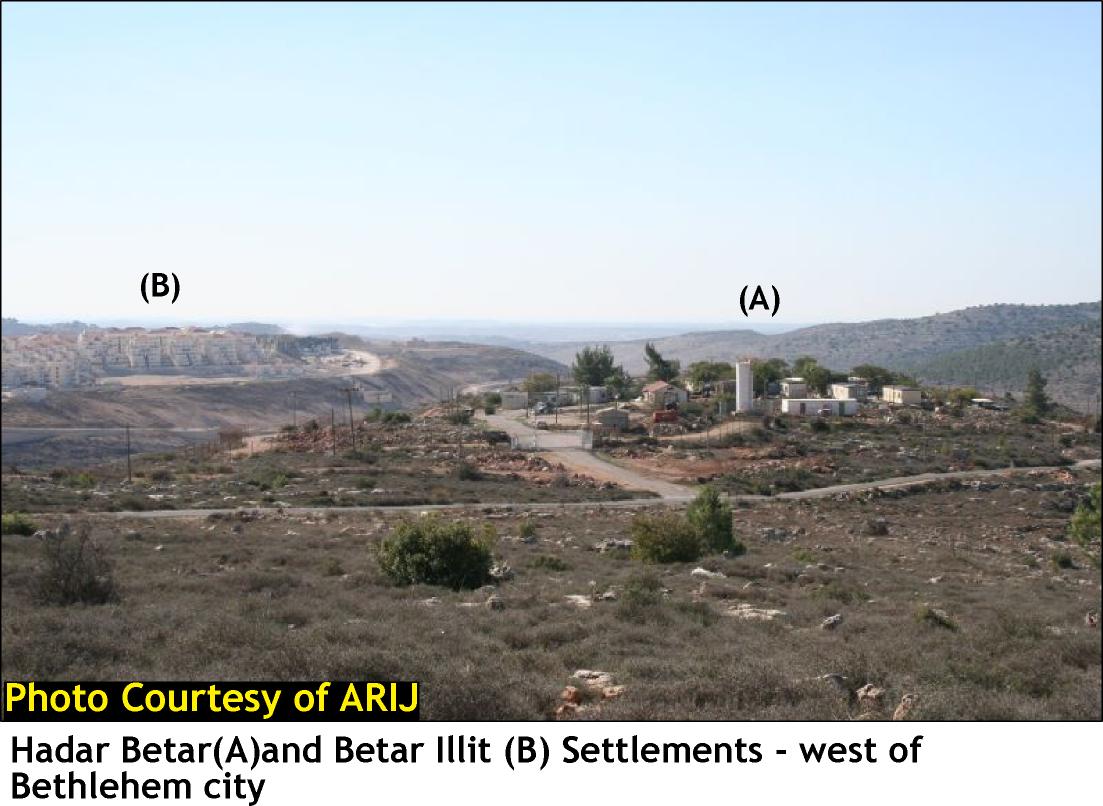
- Following the Israeli Occupation of the Palestinian Territory (The West Bank including East Jerusalem and the Gaza Strip), Husan Village, as many other Palestinian cities and villages in the West Bank, has lost some of its lands for the establishment of Illegal Israeli settlements. A total of 3187 dunums, 47% of Husan's village lands were lost for the construction of two Israeli settlements; Hadar Betar settlement in 1978 and Betar 'Illit settlement in 1985. See Table 2 for more details:-
|
Settlement Name |
Establishment Date |
Area confiscated from Husan Village |
Percent of Total village land area |
|
Hadar Betar |
1978 |
4 |
0.05% |
|
Betar 'Illit |
1985 |
3187 |
47% |
|
Total |
3191 |
|
|
Source: ARIJ GIS & RS Unit – 2008
-
The Israeli Bypass Road number 375 was constructed on lands of Husan village to connect the two aforementioned settlements (Hadar Betar & Betar 'Illit) with the rest of Gush Etzion settlement bloc. and with settlements inside Jerusalem. The bypass road has also split Husan village into two parts (Northern and Southern-see map), and caused the confiscation of more Palestinian lands in the village. The road has also made another portion of Palestinian lands in the village inaccessible as such lands acted as buffer zone to the aforementioned bypass road where any kind of Palestinian utilization is prohibited.
-
The Israeli Segregation Plan will confine the western rural villages of Battir, Husan, Nahalin, Wadi Fukin, Al Jab'a, Khallet 'Afaneh ('Afaneh hamlet), Khallet Beit Sakaria (Beit Sakaria hamlet) and Khallet Al Ballutah (Al Balluta hamlet) in one Big Ghetto; The segregated area includes the aforementioned Palestinian villages in addition to the 11 settlements of the Gush Etzion bloc. Moreover, the Segregation Wall plan imposes a systemic challenge to the local and national health care and educational services. The Wall, upon completion, will make it much more difficult for Palestinians to reach hospitals, medical centers, schools, colleges universities and institutions situated in nearby cities such as Bethlehem. Access will be controlled by Israeli occupying forces and based on the Israeli permit system.
To conclude:-
The confiscation and destruction of Palestinian land is clear violation of the Fourth Geneva Convention, Article 147 which clearly prohibits extensive destruction and appropriation of property, not justified by military necessity and carried out unlawfully and wantonly; and Article 49 of the Fourth Geneva Convention also states that: ' Individual or mass forcible transfers, as well as deportations of protected persons from occupied territory to the territory of the Occupying Power or to that of any other country, occupied or not, are prohibited, regardless of their motive.' Violations of Articles of the Fourth Geneva Convention constitute breaches of the Convention and should be prosecuted as War Crimes.
Also Israel continues to violate its obligations as an occupying power under international law rules. The Israeli practices in the Palestinian territory clearly contradict with:
-
The International Covenant on Economic, Social and Cultural Rights (ICESCR) – Food (ICESCR, art. 11): The States Parties to the present Covenant recognize the right of everyone to an adequate standard of living for himself and his family, including adequate food, clothing and housing, and to the continuous improvement of living conditions. The States Parties will take appropriate steps to ensure the realization of this right, recognizing to this effect the essential importance of international co-operation based on free consent.
-
The International Covenant on Civil and Political Rights (ICCPR) – Property (ICCPR, article 1) provides that: All peoples have the right of self-determination. By virtue of that right they freely determine their political status and freely pursue their economic, social and cultural development.
:::::::::::::___
[1] Military Order #59 (1967?) – establishes the Israeli Military-appointed position of 'Custodian of Government Property' to take over land owned by the Jordanian Government. Also, allows the 'Custodian of Government Property' to appropriate land from individuals or groups by declaring it 'Public Land' or 'State Land', the latter which it defines as land that was owned or managed by, or had a partner who was an enemy body or citizen of an enemy country during the 1967 war (amended by M.O.1091).
[2] Bypass Road # 375 (Existing): stretches almost half a kilometer (0.492 kilometers) from the northeast of Wadi Fukin, passes along Betar Illit and Hadar Betar settlements to finally intersect with bypass road 60 (the main north-south artery of the West Bank). Palestinian travel without a permit is forbidden on this road otherwise they are prohibited to use the road.
Prepared by
The Applied Research Institute – Jerusalem


