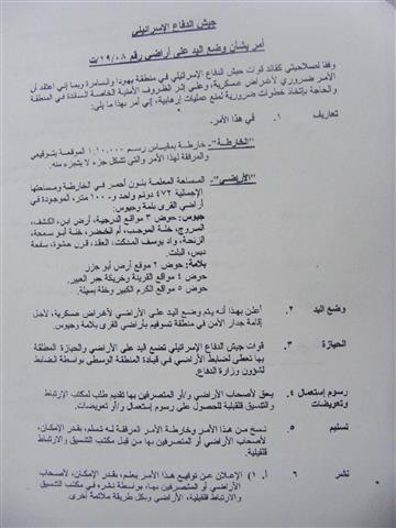
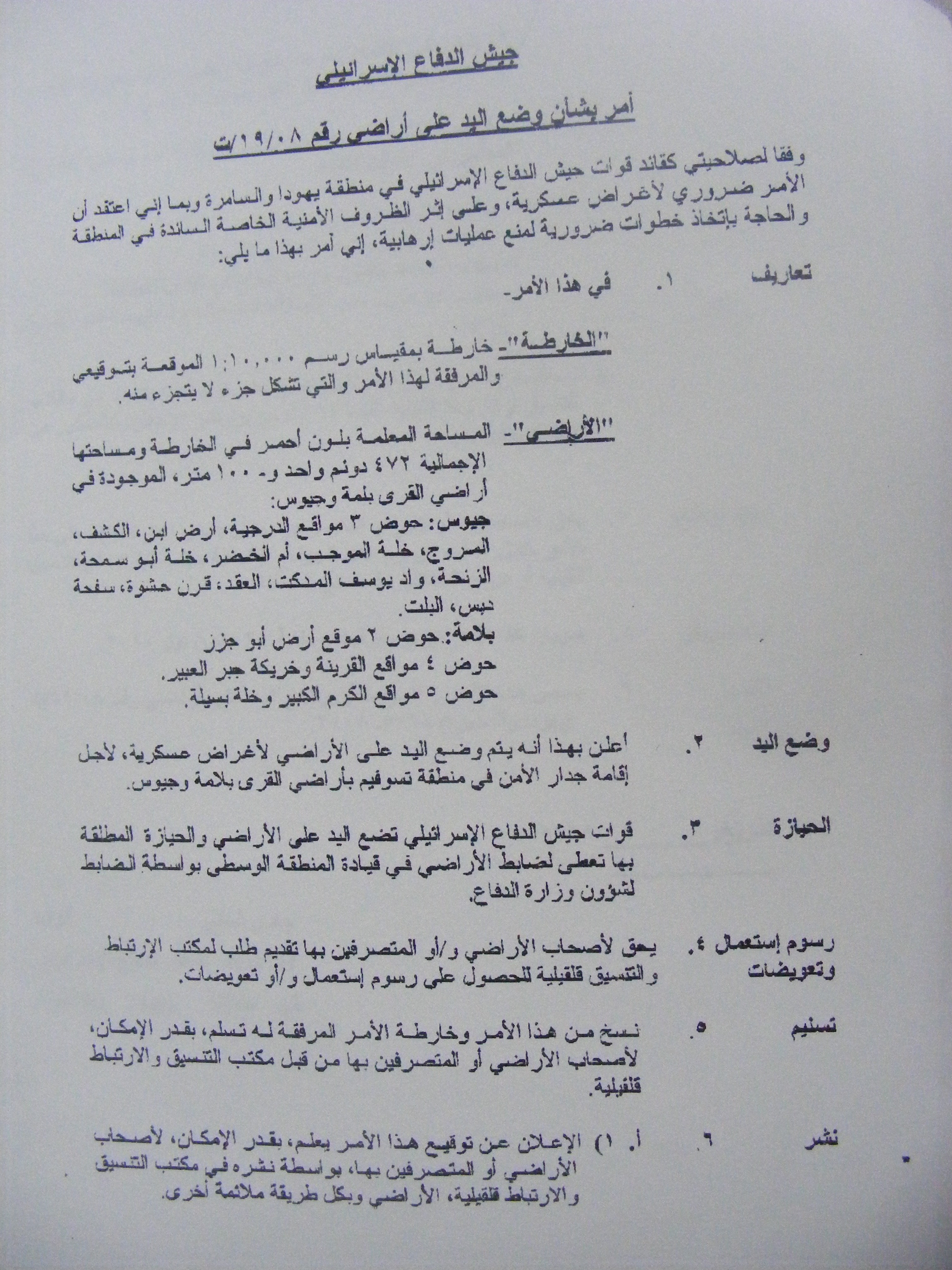
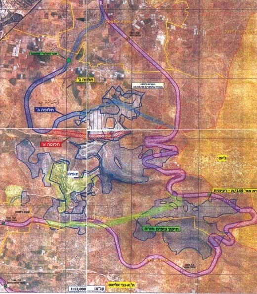
The Jayyous Village Council received on the 2nd of September, 2008 an Israeli military order number T/19/08 signed by the head of the occupation army in the West Bank . The Order called for the confiscation of 427 dunums of the lands of the villages of Jayyous and Flamiya. The confiscated lands (located in Parcels 2, 4 and 5) will be used for the re-routing of the Israeli Wall located west of the two villages.
It is worth pointing out that in May 2008 the Israeli occupation army distributed a suggested military map for changing the route of the Wall. The map took into consideration the recommendations of both the army and the colony council of the nearby colony of Tzufim. The new military order was issued in accordance with the May map. At least 4 different plans and maps have been suggested in the past 5 years to change the route of the Wall in the Governorate of Qalqilia, especially in the area of Jayyous where initial work on the Wall have devastated the agricultural sector on the village. Today an additional 427 dunums will be damaged because of the Wall. It seems that in all events, the Palestinian farmer always ends up paying a dear price.
The fate of the new military order will be decided on the 24th of October, 2008 in an Israeli High Court of Justice session as Jayyous residents have filed a case against the Israeli Army to change the route of the Wall.
The Israeli Isolation Wall in the Village of Jayyous:
As a result of the establishment of the Racist Wall atop 600 dunums of the lands of the village, its area shrunk to a mere 3,300 dunums while an additional 8,600 dunums were isolated behind the Wall. The isolated section of the village has about 120 dunums of Green Houses in addition to more than 50,000 citrus trees as well as 6 artesian wells. Around 4,000 olive trees were also uprooted to make way for the Wall in the village.
The Wall penetrates the village at a depth of 4 kilometers from its northwestern direction and at a depth of 6 kilometers from its southeastern direction. Some houses in the village are located only a few meters away from the Wall especially in the villages’ western and southern directions.
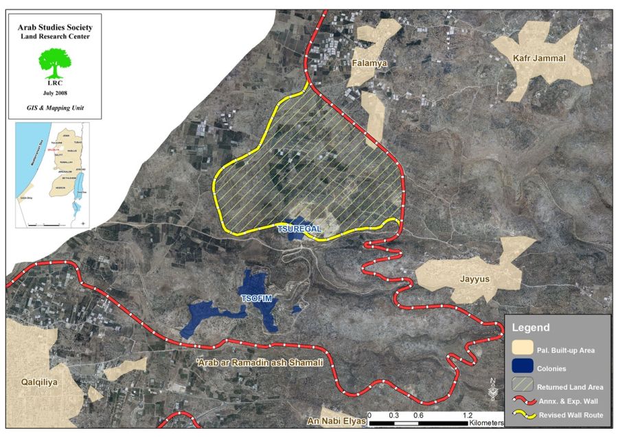
The length of the Wall in the village is 6 kilometers which caused a severe case of lack of access to lands isolated behind the Wall. There are only two gates in the Wall carrying the numbers 943 and 979 from which Palestinians can access their lands. See Photo 1
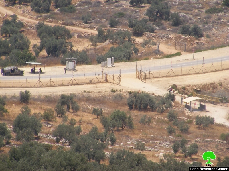
Photo 1: Gate No. 943
For more information and background information regarding the issue of re-routing the Israeli Isolation Wall and the effects of such a change, please refer back to the following two case studies by the Land Research Center:
-
Israeli army intends to amend Israeli Isolation Wall in Jayyous Qalqilya.
-
Israeli Occupation Forces Stop Palestinian Building in the Town ofJayyous – Qalqilia Governorate.
Prepared by:
The Land Research Center
LRC


