The so-called Israeli 'Civil Administration of Judea and Samaria' issued an order number 05/1720 concerning the village of Zeef in the town of Yatta. The Order, which was published in Al Quds newspaper on May 21, 2008, indicated that 'in accordance with Article Number 24 (5)(6) from the Structure, Village and Town Regulation Law number 79 issued on the year 1966, the Civil Administration declares that the Master Plan number 10/1720 for the village of Zeef is officially recognized and is currently taking effect.' The Order indicated that the Master Plan will take effect 15 days after its publication in the official newspaper. It was signed by EngineerShlomo Moskovitz in his capacity as the head of the Committee for Local Planning in the so-call 'Civil Administration'. The proposed Master Plan targeted Parcel 5 from the City of Hebron and Parcel 6 from the town of Yatta which included the village of Zeef and the khirbets of Hreiz, Ad Duwair and Marj Al Douda.
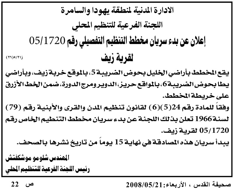
Photo 1: the advertisement/order issued by the 'Civil Administration' and published in Al Quds newspaper.
Al Quds newspaper has published a similar ad regarding the Master Plan of the said localities on November 15th, 2006 which indicated that a decision was made to produce a regulatory map for the village of Zeef. It called upon those concerned about the Plan to head to Bet El to check its details and make the appropriate objections.
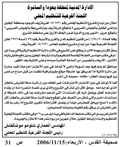
Photo 2: the advertisement issued by the �Civil Administration� in 2006.
In the aftermath of the 2006 advertisement, the residents of the village solicited the services of two lawyers to look upon the details of the decision and make the necessary objections. It turned out that the decision was accompanied by a map that designated a built-up area within a blue rectangle. No building is allowed beyond the designated blue area without a building permit issued by the 'Civil Administration'. Even building within the blue area has to meet specific conditions; a maximum of three floors can be built with a maximum area of 250 m2 and only after obtaining a building permit. All told, the area where building is allowed is only 231 dunums out of the original 3000 dunums area of the village of Zeef.
Mr. Mohammad Shatat, the head of Zeef's village council indicated the following to the Land Research Center's field researcher: ' In March 2007 we went to the headquarters of the 'Civil Administration' in Bet El to object to the proposed Plan. We took with us our official documents and maps showing the exact location and the total area of our village. The officers in charge of our file told us that we had to move 100 meters away on each side of By-Pass Road 60 which cuts through Zeef. We filed a case at the Israeli High Court against the proposed plan. So far, we did not receive an answer from the Court.
It is worth noting here that By-Pass Road 60 crosses the village of Zeef near khirbet Hreiz. The Road was present since the Jordanian era, yet Israeli occupation forces refurbished it in 1997 and used it for the benefit of the Israeli colonists living in the colonies of Karmel, Ma'on and Susiya.
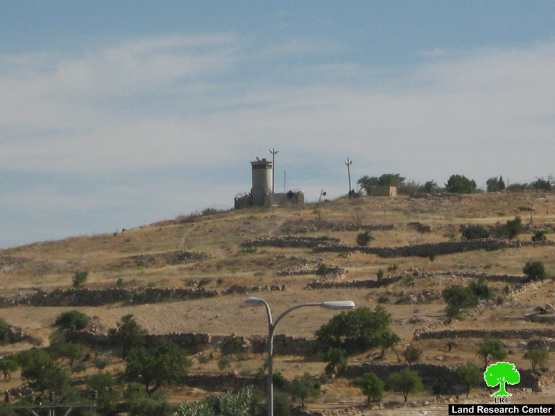
Photo 3: Part of Road 60 which crosses Zeef near khirbet Hreiz
Mr. Shatat continued: ' The proposed plan prevents the residents of the area from expanding due to natural growth on their 2000 dunums land. Occupation forces aim at confiscating the land for the purpose of establishing other colonial by-pass roads in the area.
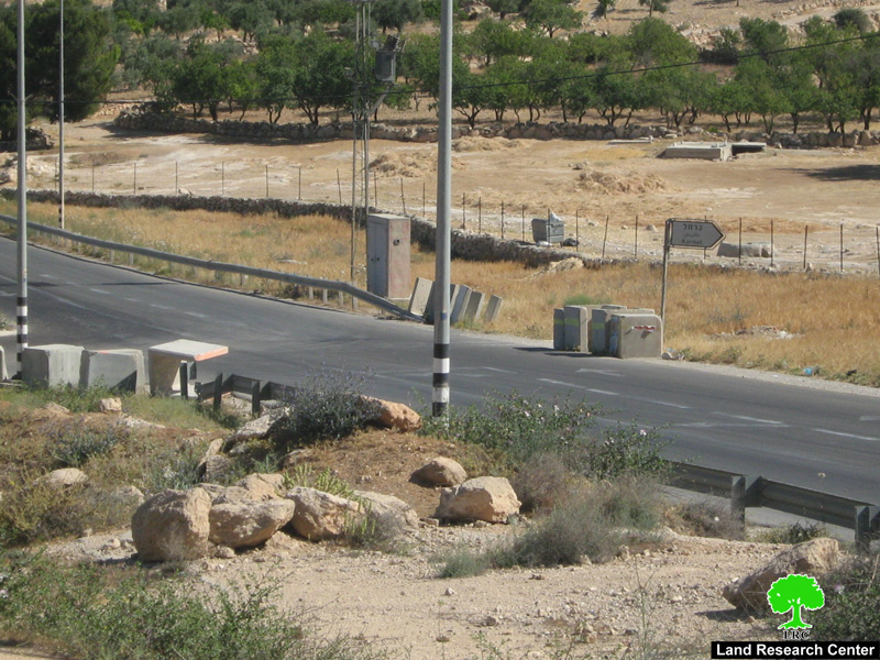
Photo 4 : part of Bypass Road 60 penetrates the lands of Zeef village
Tens of Houses are Under Demolition Threat due to the Plan:
Examining the Blue Area on the map illustrate that a number of houses located outside its limit in the areas of Al Fahja, Hreiz and Ad Duweir are under the threat of being demolished. That is despite the fact that most of these houses were built in the 1970s; i.e. before the by-pass road. Of these threatened houses, 18 are located in Al Fahja, 6 in Hreiz and 4 in Ad Duwair. The number of Palestinians who can become homeless in these areas is about 250 in addition to 500 students enrolled in Zeef Elementary School as it is located outside the Blue Area. The following table lists the heads of households whose houses are under the threat of being demolished due to the proposed Master Plan:
|
Location |
Household Owners |
Number of Houses |
|
Al Fahja |
Ali Yousef Jabarin |
2 |
|
Al Fahja |
Mahmoud Yousef Jabarin |
2 |
|
Al Fahja |
Mohammad Yousef Jabarin |
2 |
|
Al Fahja |
Khalil Mohammad Jabarin |
1 |
|
Al Fahja |
Maher Ibrahim Jabarin |
2 |
|
Al Fahja |
Isma�eel Ibrahim Jabarin |
1 |
|
Al Fahja |
Ibrahim Jabarin |
1 |
|
Al Fahja |
Musa Mohammad Abed Rabbo Jabarin |
1 |
|
Al Fahja |
Ali Khalil Ibrahim Abu Iram and his sons |
3 |
|
Al Fahja |
Zuhair Majed Abu Iram |
3 |
|
Total in Al Fahja |
18 |
|
|
Hreiz |
Khaled Ahmad Abed Rabbo |
1 |
|
Hreiz |
Hilmi Ahmad Abed Rabbo |
1 |
|
Hreiz |
Abdullah Issa Al Jundi |
1 |
|
Hreiz |
Aziz Khalil Shatat |
1 |
|
Hreiz |
Mahmoud Yousef Shatat |
1 |
|
Hreiz |
Ahmad Khalil Shatat |
1 |
|
Total in Hreiz |
6 |
|
|
Ad Duwair |
Ibrahim Abu Sbeih |
1 |
|
Ad Duwair |
Khaled Abdel Samee' Juneid |
1 |
|
Ad Duwair |
Rawhi Abu Hammad |
1 |
|
Ad Duwair |
Ayyoub Rasheed Awad Allah |
1 |
|
Total in Ad Duwair |
4 |
|
|
TOTAL |
28 |
|
The residents of the village demanded the national and international community to stand by them and to pressure the Israeli occupation authorities to change the proposed Master Plan. They have also demanded some clarifications from these authorities regarding the fate of the houses that, according to the Plan, have remained outside of the Blue Area.

Photo 5: the Map as distributed by the Israeli Occupation Forces and shows
the master plan of Zeef Village according to the Israeli Civil Administration.
Zeef in Brief:
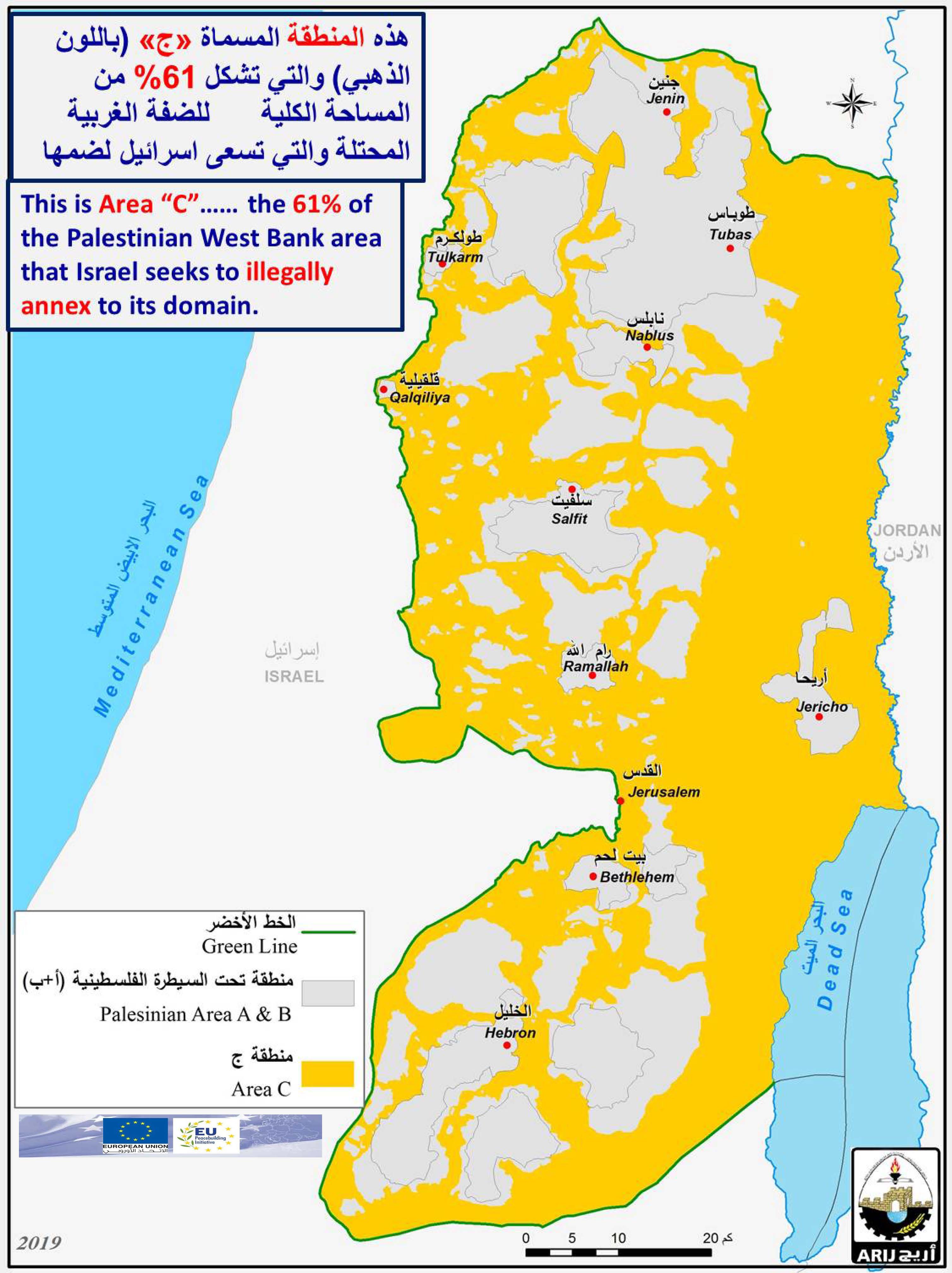
The village of Zeef is located north east of the town of Yatta. Its population is about 2,000 Palestinians whose affairs are run by a village council since 1998. The area of the village is about 3,000 dunums most of which are planted with olive and almond trees in its valleys. Most of its residents work in agriculture and herding. The village has a mosque, a mother-and-child clinic, an elementary school, a water and electricity networks as well as a partial phone network. A number of its houses were demolished by Israeli occupation forces under the pretext of lack of permit. Between 1983 and 2002 around 24 houses were demolished for that reason. See Map 1

Prepared by:
The Land Research Center
LRC