The Israeli Occupation Authorities recently issued a master plan for Khirbet Jubara in Tulkarem Governorate. The new master plan defines only 75 dunums of land as built-up area while the khirbet's houses are currently spread over an area of 135 dunums of land. The Israeli plans also excluded 8 already existing Palestinian houses along with a school and are all now considered as 'illegal constructions' and face the threat of demolition. The Israeli plan shows no consideration to the Palestinian current and future needs; on the contrary, it imposes more restrictions and risks on any future Palestinian construction in that particular area.
Prior to this development, a demolition notification was issued in September 2007 against the same school under the pretext of un-licensing, although it was built by local donations to meet the increasing need for class rooms in the Khirbet.
In the same context, a second demolition order was issued against the house of Mr. Ziyab Abdullah Abu Safiya, 56 years old, for un-licensing and for being close to the path of the Israeli Segregation Wall, although it was built long time before the commencement of wall constructions.

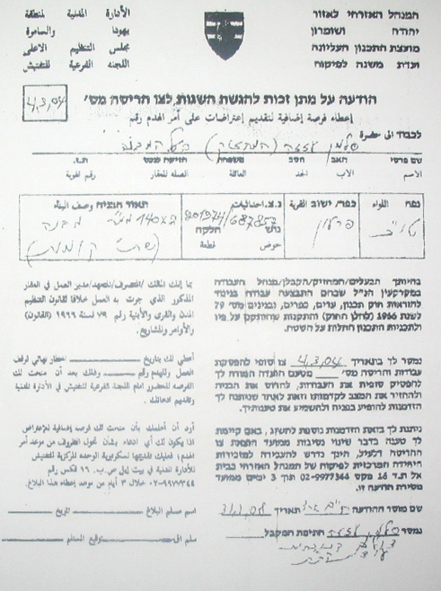
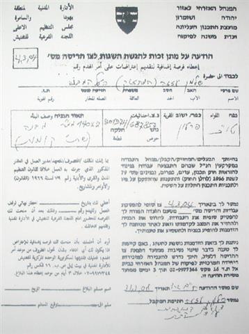
(Photo 1 & Photo 2: copies of demolition orders )
In an interview with LRC field worker, Mr. Abu Safiya said' 'I got my house built in the year 1981, almost 22 years before the construction of the Wall. The house is a modest one with only two rooms in which I, my wife and my two disabled sons live. I was surprised when I received the demolition order last September under the pretext of un-licensing and proximity to the Wall. After that I did my best to get the licensing documents completed; I filed an appeal to Ofra military court to get the demolition order canceled. In effect, the demolition order was adjourned until the master plan has been realized. To my surprise again, I found my house out side the borders of the newly announced master plan and at the beginning of last February I got a second confirmation that my house would be destroyed by mid March, 2008 at the maximum under the pretext of being out of the borders of the Israeli announced built up area. If my house is going to be destroyed I will find my self and my family homeless with no source to live on, especially after loosing our agricultural land under the path of the Wall'.
Kherbit Jubara: Location & population
Khirbet Jubara is located 6 km to the south of Tulkarem city and has the population of 380 who derive from the nearby villages and towns of ar Ras, Faro'un and at Tayiba. The latter is located behind the 1949 Armistiuce Line (Green Line). Jubara's total land area is 394 dunums.
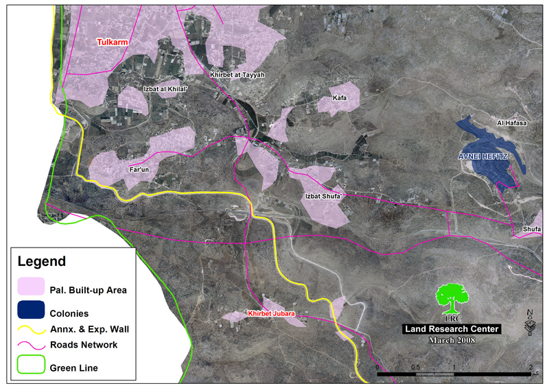
Before the construction of the Israeli Segregation Wall in June 2002, about 95 % of the Khirbet's population depended on agriculture and poultry farming as main income. According to the statistics of the Palestinian Ministry of Agriculture (PMA) for the year 2002, Khirbet Jubara was a major chicken producer in Tulkarem district – 78 farms – with almost one million chicks. In addition, there were more than 100 dunums of irrigated and covered agriculture.
It is worth mentioning that 90% of Khirbet Jubara lands are originally registered at the land registration department as part of ar Ras village, basin number 2, while the remaining area (10%) is registered as part of Farou'n land area. Until August, 2006, Khirbet Jubara had been a non-recognized village by the Israeli Occupation Authorities.
Khirbet Jubara and the Wall
The Israeli Occupation Authorities started constructing the Wall around Khirbet Jubara in July, 2003, in three directions: north, east and south with a total length of 3 km and an average width of 70 meters. As a result, the whole Khirbet was isolated inside the Wall.
The following are some of the effects of the Wall on Khirbet Jubara:
1. The destruction of about 150 dunums of fertile agricultural land under the path of the Wall;
2. The whole village population � 380- were separated behind its path and found themselves in a big canton where no access is allowed to non-residents without prior arrangement and acquisition of proper documents from the Israeli military for whatever purpose. Two Wall gates � number 22 and 753- were built on the Wall but remain closed most of the time.
3. The destruction of the agricultural life in the Khirbet due to the closure of most poultry farms and destruction and/or isolation of cultivated land by the Wall.
4. The total isolation of two houses from the rest of the Khirbet: the two storey house of Mr. Yusif Ali Badran, 43 years old and father of 8; and, the two storey-house of Mr. Azmi ad Damiri, 57 years old and father of 7.

Prepared by:
The Land Research Center
LRC