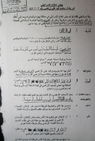
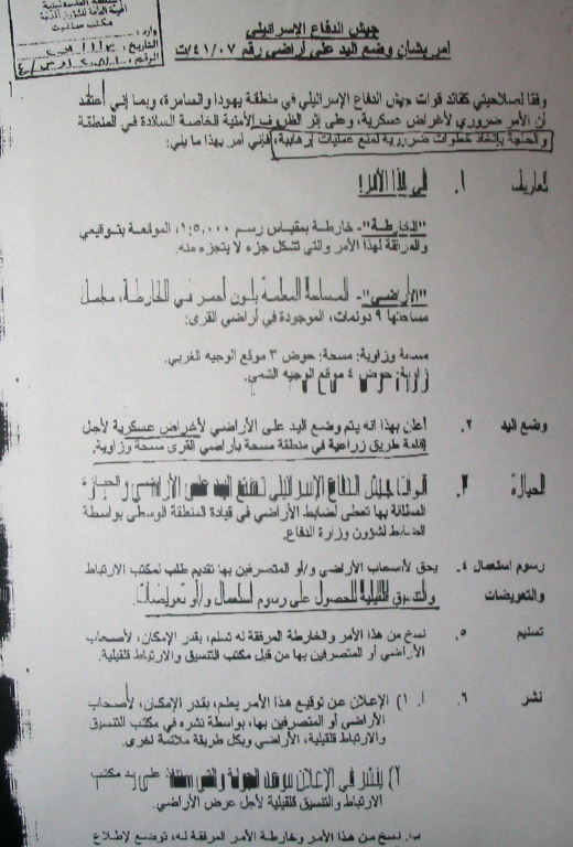
On January 8th, 2008 Israeli occupation authorities declared its intention of confiscating 9 agricultural dunums in Parcel 3 in a location called Al Wajh Al Gharbi of the village of Masha as well as in parcel 4 in a location called Al Wajh Al Shami in the village of Al Zawiya. The confiscation order held the number T/41/07 which stated that the goal of the confiscation is the establishment of a new �agricultural� road.

 c
c
Photo 1 �A+B�: The Israeli Occupation Confiscation Order
A False Claim:
Despite the fact that the residents of the village of Al Zawiya have rejected the plans for the new colonial road suggested to them by the Israeli DCL, Israeli occupation forces began working on the road on January 15th, 2008. The length of the road is 2 kilometers. Its construction will lead to the plowing and destruction of around 20 dunums of Palestinian lands. Throughout the years, Palestinian landowners were prevented from reaching and rehabilitating the targeted lands which belong to Jamal Abdulla Abu Beeh and Ra�afat Hasan Qadoos (both from Al Zawiya) as well as Sadeq Deeb Oudeh and Abdel Khaliq Hasan Amer (both from Masha). Israeli occupation authorities indicated that the goal of the confiscation is the construction of an agricultural road. However, facts on the grounds indicate that the road is designed to serve occupations� goals as it passes near the colonial Road 5 (which confiscated 400 dunums of the lands of Al Zawiya). The real intention behind the newly-constructed road is to connect between the colony of Alkana and Road 5 which means that the road is constructed to serve colonial purposes, and not for the benefit of the Palestinian farmers as claimed by the occupation.
The residents of Al Zawiya village indicate that the real purpose behind establishing the road is the isolation of an additional 60 dunums of Palestinian lands to be used later for further colonial expansion. They have refused to engage or deal with the Order saying that if the people of the village needed an agricultural road, they would establish it themselves.
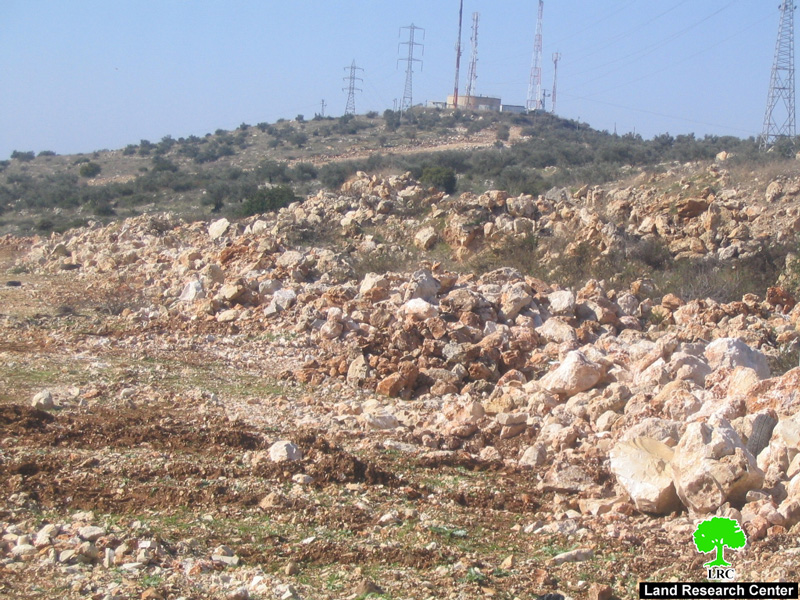
Photo 2: Plowing of Palestinian lands to establish the said road � Al Zawiya Village
The Occupation Distributes a Map Listing its Real Intentions:
On December 20th, 2007 Israeli occupation forces distributed a map it claimed on it that the goal of the confiscation is to establish an agricultural road to �facilitate and improve the ability of farmers to reach their farmland located in Khirbet Sirisya.� The Khirbet is located northwest of the village of Al Zawiya and in the vicinity of the Israeli Racist Isolation Wall which separates the village from the nearby village of Azzoun Al Itma. In reality, the land is inaccessible as the Israeli occupation forces have declared it in the past to be �Closed Military Area� to which Palestinians are not allowed into due to its close proximity to the colony of Burqan and Road 5. Putting all these facts together gives a clear picture that the motive behind constructing the road is for purely Israeli security reasons and not for the benefit of the Palestinian farmers as claimed by the forces of the occupation.
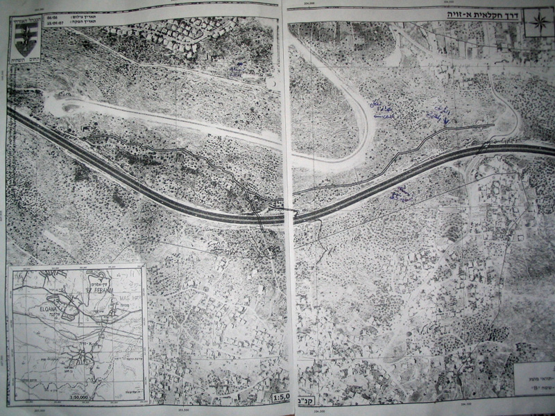
Photo 3: The map distributed by the Israeli occupation authorities showing the
new road on the lands of Al Zawiya village.
One of the farmers sustaining damages due to the construction of the road said the following: 'Israel always declares that it is a civilized state. However, it forgets that through its actions it has become without any morals as it acts as if it is above all laws. It prevents the farmers from reaching their lands to look for olives and thyme. It confiscates lands under ridiculous pretexts as it disrupts the livelihood of the farmers. Israel drowned in aggression and sadism as it has become a tool to institutionalize racism.'
Colonies, the Wall, and By-Pass Colonial Roads: Cancer Chipping Away at Al Zawiya Lands:
The village of Al Zawiya is considered to be one of the Palestinian towns that has witnessed (and continues to witness) an organized campaign by the Israeli occupation forces and authorities to control the villages� agricultural lands and to transfer its population using a multitude of methods. The village has lost around 12,000 dunums of its lands during the 1948 war as these lands became located west of the Green Line. More than 600 dunums were destroyed when the Racist Isolation Wall was built atop it in 2003 for a distance of 6 kilometers with a width reaching up to 100 meters. An additional 4,000 dunums were isolated behind the Wall while 400 dunums were destroyed in the first phase of the establishment of the Wall before its route was amended. Furthermore, Israeli occupation authorities have confiscated in the year 2000 around 400 dunums to be used in the establishment of Trans-Samaria Road 5 with a length of 4 kilometers and a width of 100 meters, leading to a wide-spread destruction in the agricultural lands and the uprooting of hundreds of olive trees.

Photo 4: Trans-Samaria Road 5 isolating Palestinian lands � Al Zawiya Village.
Moreover, Israeli occupation authorities took advantage of the difficulty andor inability of Palestinian landowners to reach their lands and enlarged the area of the quarry located west of the Racist Wall to become about 500 dunums. These authorities also confiscated 300 dunums of the lands of the village for the purpose of the establishment of an army training base.
Background Info about the Village:
The village of Al Zawiya is located on the Green Line at a distance of 15 kilometers west of the City of Salfeet. According to the 2006 statistics, the population of the village was 4900. About 81% of the population depends on agricultures and herding as the main source of income while the remaining 19% depend on working in the public and private sectors.
Currently, the area of the village (after the establishment of the Wall) is about 2,700 dunums. The built-up area is about 900 dunums. Most of the agricultural lands in the village are planted with olive and fig trees.
There are 3 main families in the village; Shaqir, Moqidi and Raddad comprising 95% of the total population of the village. The remaining 5% consists of small refugee families including Al Rabi family.
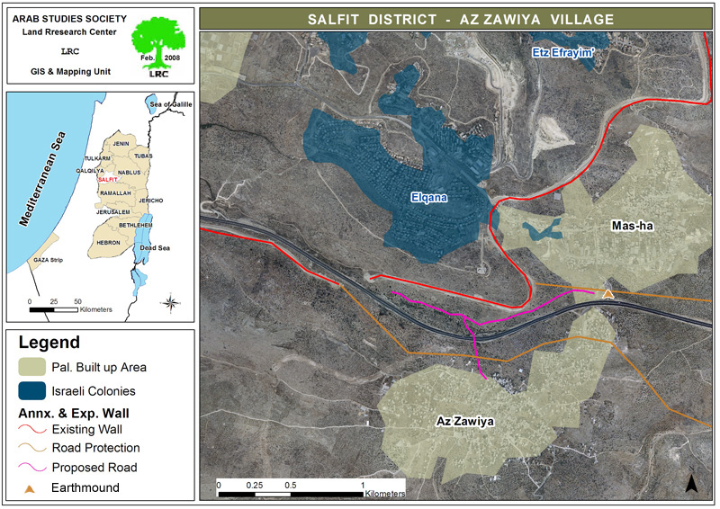
Map 1: A map showing the route of the colonial road on the lands of Al Zawiya village.
Prepared by
The Land Research Center
LRC


